当前位置:
X-MOL 学术
›
Appl. Geogr.
›
论文详情
Our official English website, www.x-mol.net, welcomes your
feedback! (Note: you will need to create a separate account there.)
GIS database of groundwater flow characteristics in carbonate aquifers: Tracer test inventory from Slovenian karst
Applied Geography ( IF 4.0 ) Pub Date : 2020-05-01 , DOI: 10.1016/j.apgeog.2020.102191 Metka Petrič , Nataša Ravbar , Petra Gostinčar , Petra Krsnik , Marina Gacin
Applied Geography ( IF 4.0 ) Pub Date : 2020-05-01 , DOI: 10.1016/j.apgeog.2020.102191 Metka Petrič , Nataša Ravbar , Petra Gostinčar , Petra Krsnik , Marina Gacin
|
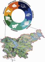
Abstract Karst aquifers that supply manifold ecosystem services, such as freshwater resources, and possess unique underground biodiversity are characterized by peculiar flow processes and are thus particularly susceptible to destruction. Their efficient protection is based on artificial tracing results that are usually scattered among different sources. In the case of Slovenia, the results of 231 available tracer tests, performed between 1905 and 2019, have been assembled, arranged and georeferenced. The inventory of the geospatial database, which is unique on a global scale, contains 36 different pieces of data for each tracing that have been compiled using geographic information system tools. In this study, the basic concepts, the step-by-step workflow and a detailed mapping procedure have been presented. The thorough collection of available data that is freely accessible online includes data on the date, location and details of implementation of the tracer test and on the identified groundwater flow characteristics. Also available are the sources of the published or unpublished reports from which the data were taken. The database includes a comment on the tracer test implementation or results. The inventory is very useful in the process of the integrated management of karst water sources, and especially as an early-warning and monitoring system tool in cases where there is an imminent danger of pollution, which requires a fast and accurate response. The database production is transferable to other karst-rich countries.
中文翻译:

碳酸盐含水层地下水流特征的 GIS 数据库:来自斯洛文尼亚喀斯特的示踪剂测试清单
摘要 喀斯特含水层提供淡水资源等多种生态系统服务,并具有独特的地下生物多样性,具有独特的流动过程,因此特别容易受到破坏。它们的有效保护基于通常分散在不同来源之间的人工追踪结果。以斯洛文尼亚为例,1905 年至 2019 年间进行的 231 次可用示踪剂测试的结果已经汇总、排列和地理参考。地理空间数据库的清单在全球范围内是独一无二的,其中包含使用地理信息系统工具编制的每次追踪的 36 条不同数据。在本研究中,介绍了基本概念、分步工作流程和详细的映射程序。全面收集可在线免费访问的可用数据,包括有关实施示踪剂测试的日期、地点和细节以及已确定的地下水流特征的数据。还可以获得已发布或未发布的数据来源报告。数据库包括对跟踪器测试实施或结果的评论。该清单在岩溶水源综合管理过程中非常有用,特别是在污染危险迫在眉睫的情况下作为预警和监测系统工具,需要快速准确的响应。数据库生产可转移到其他岩溶丰富的国家。示踪剂测试的位置和实施细节以及确定的地下水流特征。还可以获得已发布或未发布的数据来源报告。数据库包括对跟踪器测试实施或结果的评论。该清单在岩溶水源综合管理过程中非常有用,特别是在污染危险迫在眉睫的情况下作为预警和监测系统工具,需要快速准确的响应。数据库生产可转移到其他岩溶丰富的国家。示踪剂测试的位置和实施细节以及确定的地下水流特征。还可以获得已发布或未发布的数据来源报告。数据库包括对跟踪器测试实施或结果的评论。该清单在岩溶水源综合管理过程中非常有用,特别是在污染危险迫在眉睫的情况下作为预警和监测系统工具,需要快速准确的响应。数据库生产可转移到其他岩溶丰富的国家。该清单在岩溶水源综合管理过程中非常有用,特别是在污染危险迫在眉睫的情况下作为预警和监测系统工具,需要快速准确的响应。数据库生产可转移到其他岩溶丰富的国家。该清单在岩溶水源综合管理过程中非常有用,特别是在污染危险迫在眉睫的情况下作为预警和监测系统工具,需要快速准确的响应。数据库生产可转移到其他岩溶丰富的国家。
更新日期:2020-05-01
中文翻译:
碳酸盐含水层地下水流特征的 GIS 数据库:来自斯洛文尼亚喀斯特的示踪剂测试清单
摘要 喀斯特含水层提供淡水资源等多种生态系统服务,并具有独特的地下生物多样性,具有独特的流动过程,因此特别容易受到破坏。它们的有效保护基于通常分散在不同来源之间的人工追踪结果。以斯洛文尼亚为例,1905 年至 2019 年间进行的 231 次可用示踪剂测试的结果已经汇总、排列和地理参考。地理空间数据库的清单在全球范围内是独一无二的,其中包含使用地理信息系统工具编制的每次追踪的 36 条不同数据。在本研究中,介绍了基本概念、分步工作流程和详细的映射程序。全面收集可在线免费访问的可用数据,包括有关实施示踪剂测试的日期、地点和细节以及已确定的地下水流特征的数据。还可以获得已发布或未发布的数据来源报告。数据库包括对跟踪器测试实施或结果的评论。该清单在岩溶水源综合管理过程中非常有用,特别是在污染危险迫在眉睫的情况下作为预警和监测系统工具,需要快速准确的响应。数据库生产可转移到其他岩溶丰富的国家。示踪剂测试的位置和实施细节以及确定的地下水流特征。还可以获得已发布或未发布的数据来源报告。数据库包括对跟踪器测试实施或结果的评论。该清单在岩溶水源综合管理过程中非常有用,特别是在污染危险迫在眉睫的情况下作为预警和监测系统工具,需要快速准确的响应。数据库生产可转移到其他岩溶丰富的国家。示踪剂测试的位置和实施细节以及确定的地下水流特征。还可以获得已发布或未发布的数据来源报告。数据库包括对跟踪器测试实施或结果的评论。该清单在岩溶水源综合管理过程中非常有用,特别是在污染危险迫在眉睫的情况下作为预警和监测系统工具,需要快速准确的响应。数据库生产可转移到其他岩溶丰富的国家。该清单在岩溶水源综合管理过程中非常有用,特别是在污染危险迫在眉睫的情况下作为预警和监测系统工具,需要快速准确的响应。数据库生产可转移到其他岩溶丰富的国家。该清单在岩溶水源综合管理过程中非常有用,特别是在污染危险迫在眉睫的情况下作为预警和监测系统工具,需要快速准确的响应。数据库生产可转移到其他岩溶丰富的国家。


 京公网安备 11010802027423号