当前位置:
X-MOL 学术
›
Geomorphology
›
论文详情
Our official English website, www.x-mol.net, welcomes your
feedback! (Note: you will need to create a separate account there.)
A random forest model of landslide susceptibility mapping based on hyperparameter optimization using Bayes algorithm
Geomorphology ( IF 3.1 ) Pub Date : 2020-08-01 , DOI: 10.1016/j.geomorph.2020.107201 Deliang Sun , Haijia Wen , Danzhou Wang , Jiahui Xu
Geomorphology ( IF 3.1 ) Pub Date : 2020-08-01 , DOI: 10.1016/j.geomorph.2020.107201 Deliang Sun , Haijia Wen , Danzhou Wang , Jiahui Xu
|
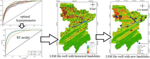
Abstract The choice of model parameters in landslide susceptibility mapping makes a major determinant of model accuracy. The purpose of this study is to optimize the hyperparameters based on a Bayesian optimization algorithm, and to obtain a high accuracy random forest landslide susceptibility evaluation model. The research steps are detailed as follows. Firstly, taking a typical landslide prone mountainous area as an example, 16 conditioning factors, such as elevation, annual average rainfall, distance from roads, distance from buildings and so on, were preliminarily selected as the conditioning factors of landslide susceptibility. Combined with 1520 historical landslide events, a geospatial database was established with 30 m resolution. Secondly, the geospatial data sample set was constructed by random sampling according to ratio of historical landslides and non-landslides of 1:10. Based on the whole sample set, the random forest model adopted the Bayesian optimization algorithm to optimize the hyperparameters. Next, the optimal hyperparameters were selected to be trained to get the evaluation model of landslide susceptibility. In addition, they were carried out the analysis of landslide susceptibility mapping for the whole study area. After that, the recursive feature elimination method was used to screen out the dominant conditioning factors that can explain the degree of landslide susceptibility. The results indicated that the area under curve (AUC) values of receiver operating characteristic (ROC) curve in training data set, verification data set and regional simulation were 0.95, 0.87 and 0.93, respectively. 65% of the historical landslides fell between the high susceptibility and very high susceptibility regions, which made up
中文翻译:

基于贝叶斯算法超参数优化的滑坡敏感性映射随机森林模型
摘要 滑坡敏感性绘图中模型参数的选择是模型精度的主要决定因素。本研究的目的是基于贝叶斯优化算法优化超参数,获得高精度的随机森林滑坡敏感性评价模型。研究步骤详述如下。首先,以典型的滑坡多发山区为例,初步选取海拔、年平均降雨量、距道路距离、距建筑物距离等16个条件因子作为滑坡易发性条件因子。结合1520次历史滑坡事件,建立了30m分辨率的地理空间数据库。第二,地理空间数据样本集是按照历史滑坡与非滑坡1:10的比例随机抽样构建的。随机森林模型基于整个样本集,采用贝叶斯优化算法对超参数进行优化。接下来,选择最优超参数进行训练,得到滑坡敏感性评价模型。此外,他们还对整个研究区进行了滑坡敏感性绘图分析。之后,采用递推特征剔除法筛选出能够解释滑坡敏感性程度的主导条件因素。结果表明,训练数据集、验证数据集和区域模拟中受试者工作特征(ROC)曲线的曲线下面积(AUC)值分别为0.95、0。分别为 87 和 0.93。65% 的历史滑坡发生在高易发区和特高易发区之间,构成了
更新日期:2020-08-01
中文翻译:
基于贝叶斯算法超参数优化的滑坡敏感性映射随机森林模型
摘要 滑坡敏感性绘图中模型参数的选择是模型精度的主要决定因素。本研究的目的是基于贝叶斯优化算法优化超参数,获得高精度的随机森林滑坡敏感性评价模型。研究步骤详述如下。首先,以典型的滑坡多发山区为例,初步选取海拔、年平均降雨量、距道路距离、距建筑物距离等16个条件因子作为滑坡易发性条件因子。结合1520次历史滑坡事件,建立了30m分辨率的地理空间数据库。第二,地理空间数据样本集是按照历史滑坡与非滑坡1:10的比例随机抽样构建的。随机森林模型基于整个样本集,采用贝叶斯优化算法对超参数进行优化。接下来,选择最优超参数进行训练,得到滑坡敏感性评价模型。此外,他们还对整个研究区进行了滑坡敏感性绘图分析。之后,采用递推特征剔除法筛选出能够解释滑坡敏感性程度的主导条件因素。结果表明,训练数据集、验证数据集和区域模拟中受试者工作特征(ROC)曲线的曲线下面积(AUC)值分别为0.95、0。分别为 87 和 0.93。65% 的历史滑坡发生在高易发区和特高易发区之间,构成了


 京公网安备 11010802027423号