当前位置:
X-MOL 学术
›
Hydrol. Process.
›
论文详情
Our official English website, www.x-mol.net, welcomes your
feedback! (Note: you will need to create a separate account there.)
Effect of an Environmental Flow on Vegetation Growth and Health Using Ground and Remote Sensing Metrics
Hydrological Processes ( IF 2.8 ) Pub Date : 2020-02-20 , DOI: 10.1002/hyp.13689 Martha M. Gómez‐Sapiens 1 , Christopher J. Jarchow 2 , Karl W. Flessa 1 , Patrick B. Shafroth 3 , Edward P. Glenn 4 , Pamela L. Nagler 5
Hydrological Processes ( IF 2.8 ) Pub Date : 2020-02-20 , DOI: 10.1002/hyp.13689 Martha M. Gómez‐Sapiens 1 , Christopher J. Jarchow 2 , Karl W. Flessa 1 , Patrick B. Shafroth 3 , Edward P. Glenn 4 , Pamela L. Nagler 5
Affiliation
|
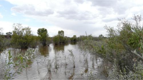
Understanding the effectiveness of environmental flow deliveries along rivers requires monitoring vegetation. Monitoring data are often collected at multiple spatial scales. For riparian vegetation, optical remote sensing methods can estimate growth responses at the riparian corridor scale, and field‐based measures can quantify species composition; however, the extent to which these different measures are duplicative or complementary is important to understand when planning monitoring programmes with limited resources. In this study, we analysed riparian vegetation growth in the delta of the Colorado River in response to an experimental pulse flow. Our goal was to compare ground‐based measurements of vegetation structure and composition with satellite‐based Landsat radiometric variables, such as the normalized difference vegetation index (NDVI). We made this comparison in 21 transects following the delivery of 131.8 million cubic meters (mcm) of water in the stream channel during the spring of 2014 as a pulse flow and 38.4 mcm as base flows. Vegetation cover increased 14% and NDVI increased 0.02 (15%) by October 2015, and both variables returned to pre‐pulse flow values in October 2016. Observed changes in vegetation structure and composition did not persist after the second year. The highest increase in vegetation cover in October 2014 and October 2015 resulted from species that could respond rapidly to additional water such as reeds (Arundo donax and Phragmites australis), cattail (Typha domingensis), and herbaceous plants. Dominant shrubs, saltcedar (Tamarix spp.) and arrowweed (Pluchea sericea), both indicative of nonrestored habitats showed variable increases in cover, and native trees (Salicaceae family) presented low increases (1%). The strong NDVI–vegetation cover relationship indicates that NDVI is appropriate to detect changes at the riparian corridor scale but needs to be complemented with ground data to determine the contributions by different species to the observed trends.
中文翻译:

使用地面和遥感指标的环境流对植被生长和健康的影响
了解沿河流输送环境流量的有效性需要监测植被。监测数据通常在多个空间尺度上收集。对于河岸植被,光学遥感方法可以估计河岸走廊尺度的生长响应,基于实地的措施可以量化物种组成;然而,在规划资源有限的监测方案时,了解这些不同措施的重复或互补程度很重要。在这项研究中,我们分析了科罗拉多河三角洲的河岸植被生长,以响应实验脉冲流。我们的目标是将基于地面的植被结构和成分测量与基于卫星的 Landsat 辐射测量变量进行比较,例如归一化差异植被指数 (NDVI)。我们在 2014 年春季向河道输送 1.318 亿立方米 (mcm) 水作为脉冲流和 38.4 mcm 作为基流水后,在 21 个断面中进行了此比较。到 2015 年 10 月,植被覆盖增加了 14%,NDVI 增加了 0.02(15%),两个变量都在 2016 年 10 月恢复到脉冲前流量值。观察到的植被结构和组成的变化在第二年之后没有持续存在。2014 年 10 月和 2015 年 10 月植被覆盖增加最多的原因是能够对额外的水做出快速反应的物种,如芦苇(芦竹和芦苇)、香蒲(香蒲)和草本植物。优势灌木,盐雪松 (Tamarix spp.) 和箭草 (Pluchea sericea),两者都表明未恢复的栖息地显示出不同的覆盖增加,和本地树木(杨柳科)呈现低增长(1%)。NDVI 与植被覆盖的强关系表明 NDVI 适合检测河岸走廊尺度的变化,但需要补充地面数据以确定不同物种对观测趋势的贡献。
更新日期:2020-02-20
中文翻译:
使用地面和遥感指标的环境流对植被生长和健康的影响
了解沿河流输送环境流量的有效性需要监测植被。监测数据通常在多个空间尺度上收集。对于河岸植被,光学遥感方法可以估计河岸走廊尺度的生长响应,基于实地的措施可以量化物种组成;然而,在规划资源有限的监测方案时,了解这些不同措施的重复或互补程度很重要。在这项研究中,我们分析了科罗拉多河三角洲的河岸植被生长,以响应实验脉冲流。我们的目标是将基于地面的植被结构和成分测量与基于卫星的 Landsat 辐射测量变量进行比较,例如归一化差异植被指数 (NDVI)。我们在 2014 年春季向河道输送 1.318 亿立方米 (mcm) 水作为脉冲流和 38.4 mcm 作为基流水后,在 21 个断面中进行了此比较。到 2015 年 10 月,植被覆盖增加了 14%,NDVI 增加了 0.02(15%),两个变量都在 2016 年 10 月恢复到脉冲前流量值。观察到的植被结构和组成的变化在第二年之后没有持续存在。2014 年 10 月和 2015 年 10 月植被覆盖增加最多的原因是能够对额外的水做出快速反应的物种,如芦苇(芦竹和芦苇)、香蒲(香蒲)和草本植物。优势灌木,盐雪松 (Tamarix spp.) 和箭草 (Pluchea sericea),两者都表明未恢复的栖息地显示出不同的覆盖增加,和本地树木(杨柳科)呈现低增长(1%)。NDVI 与植被覆盖的强关系表明 NDVI 适合检测河岸走廊尺度的变化,但需要补充地面数据以确定不同物种对观测趋势的贡献。


 京公网安备 11010802027423号