当前位置:
X-MOL 学术
›
Comput. Geosci.
›
论文详情
Our official English website, www.x-mol.net, welcomes your
feedback! (Note: you will need to create a separate account there.)
Application of multivariate geostatistics for local-scale lithological mapping – Case study of pelagic surface sediments from the Clarion-Clipperton Fracture Zone, north-eastern equatorial Pacific (interoceanmetal claim area)
Computers & Geosciences ( IF 4.2 ) Pub Date : 2020-06-01 , DOI: 10.1016/j.cageo.2020.104474 Łukasz Maciąg , Jan Harff
Computers & Geosciences ( IF 4.2 ) Pub Date : 2020-06-01 , DOI: 10.1016/j.cageo.2020.104474 Łukasz Maciąg , Jan Harff
|
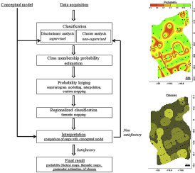
Abstract Multivariate geostatistical methods were employed to describe the local facies of surface pelagic sediments from the Interoceanmetal IOM H11 and H22 perspective areas. Using these methods, we analyze spatial variability in seafloor features, sediment grain size, and mineralogical and geochemical composition. The data were acquired from the seafloor sediments sampled by box corer. Laboratory methods included laser grain size analysis, X-Ray diffractometry and Inducted Coupled Plasma Mass Spectrometry. Universal kriging was applied in order to generate lithofacies maps, following the “classification probability kriging” concept based on a Bayesian theorem. Under this concept, the class membership probabilities are regarded regionalized variables, so that methodical tool of geostatistics can be applied. The final result is a series of thematic maps, showing the spatial distribution of classified sediments facies, expressed by class membership probabilities, which provide information on reliability of mapping. The applied models can be useful for geological exploration of Clarion-Clipperton polymetallic nodules deposit and beyond. The lithofacies maps presented here provide information on formation processes of sediments, induced by several factors, such as diagenetic transformation of sediments and pathways of biogenic, hydrogenous or hydrothermal material.
中文翻译:

多元地质统计学在局部尺度岩性测绘中的应用——赤道东北部克拉里昂-克利珀顿断裂带(大洋金属索赔区)的远洋表层沉积物案例研究
摘要 采用多元地质统计学方法描述了Interoceanmetal IOM H11和H22透视区表层远洋沉积物的局部相。使用这些方法,我们分析了海底特征、沉积物粒度以及矿物和地球化学成分的空间变异性。这些数据是从箱式取芯器采样的海底沉积物中获得的。实验室方法包括激光粒度分析、X 射线衍射法和感应耦合等离子体质谱法。遵循基于贝叶斯定理的“分类概率克里金法”概念,应用通用克里金法来生成岩相图。在这个概念下,类成员概率被视为区域化变量,从而可以应用地统计学的系统工具。最终结果是一系列专题图,显示分类沉积相的空间分布,以类成员概率表示,提供有关绘图可靠性的信息。应用模型可用于克拉里昂-克利珀顿多金属结核矿床及其他地区的地质勘探。这里展示的岩相图提供了沉积物形成过程的信息,这些过程是由多种因素引起的,例如沉积物的成岩转化和生物、氢或热液物质的途径。
更新日期:2020-06-01
中文翻译:
多元地质统计学在局部尺度岩性测绘中的应用——赤道东北部克拉里昂-克利珀顿断裂带(大洋金属索赔区)的远洋表层沉积物案例研究
摘要 采用多元地质统计学方法描述了Interoceanmetal IOM H11和H22透视区表层远洋沉积物的局部相。使用这些方法,我们分析了海底特征、沉积物粒度以及矿物和地球化学成分的空间变异性。这些数据是从箱式取芯器采样的海底沉积物中获得的。实验室方法包括激光粒度分析、X 射线衍射法和感应耦合等离子体质谱法。遵循基于贝叶斯定理的“分类概率克里金法”概念,应用通用克里金法来生成岩相图。在这个概念下,类成员概率被视为区域化变量,从而可以应用地统计学的系统工具。最终结果是一系列专题图,显示分类沉积相的空间分布,以类成员概率表示,提供有关绘图可靠性的信息。应用模型可用于克拉里昂-克利珀顿多金属结核矿床及其他地区的地质勘探。这里展示的岩相图提供了沉积物形成过程的信息,这些过程是由多种因素引起的,例如沉积物的成岩转化和生物、氢或热液物质的途径。


 京公网安备 11010802027423号