当前位置:
X-MOL 学术
›
Sci. Total Environ.
›
论文详情
Our official English website, www.x-mol.net, welcomes your
feedback! (Note: you will need to create a separate account there.)
Examining the effects of forest fire on terrestrial carbon emission and ecosystem production in India using remote sensing approaches.
Science of the Total Environment ( IF 8.2 ) Pub Date : 2020-04-03 , DOI: 10.1016/j.scitotenv.2020.138331 Srikanta Sannigrahi 1 , Francesco Pilla 1 , Bidroha Basu 1 , Arunima Sarkar Basu 1 , Konika Sarkar 2 , Suman Chakraborti 3 , Pawan Kumar Joshi 4 , Qi Zhang 5 , Ying Wang 6 , Sandeep Bhatt 7 , Anand Bhatt 8 , Shouvik Jha 9 , Saskia Keesstra 10 , P S Roy 11
Science of the Total Environment ( IF 8.2 ) Pub Date : 2020-04-03 , DOI: 10.1016/j.scitotenv.2020.138331 Srikanta Sannigrahi 1 , Francesco Pilla 1 , Bidroha Basu 1 , Arunima Sarkar Basu 1 , Konika Sarkar 2 , Suman Chakraborti 3 , Pawan Kumar Joshi 4 , Qi Zhang 5 , Ying Wang 6 , Sandeep Bhatt 7 , Anand Bhatt 8 , Shouvik Jha 9 , Saskia Keesstra 10 , P S Roy 11
Affiliation
|
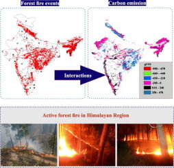
Remote sensing techniques are effectively used for measuring the overall loss of terrestrial ecosystem productivity and biodiversity due to forest fires. The current research focuses on assessing the impacts of forest fires on terrestrial ecosystem productivity in India during 2003-2017. Spatiotemporal changes of satellite remote sensing derived burn indices were estimated for both fire and normal years to analyze the association between forest fires and ecosystem productivity. Two Light Use Efficiency (LUE) models were used to quantify the terrestrial Net Primary Productivity (NPP) of the forest ecosystem using the open-source and freely available remotely sensed data. A novel approach (delta NPP/delta burn indices) is developed to quantify the effects of forest fires on terrestrial carbon emission and ecosystem production. During 2003-2017, the forest fire intensity was found to be very high (>2000) across the eastern Himalayan hilly region, which is mostly covered by dense forest and thereby highly susceptible to wildfires. Scattered patches of intense forest fires were also detected in the lower Himalayan and central Indian states. The spatial correlation between the burn indices and NPP were mainly negative (-0.01 to -0.89) for the fire-prone states as compared to the other neighbouring regions. Additionally, the linear approximation between the burn indices and NPP showed a positive relation (0.01 to 0.63), suggesting a moderate to high impact of the forest fires on the ecosystem production and terrestrial carbon emission. The present approach has the potential to quantify the loss of ecosystem productivity due to forest fires.
中文翻译:

使用遥感方法研究森林火灾对印度陆地碳排放和生态系统生产的影响。
遥感技术有效地用于衡量森林大火造成的陆地生态系统生产力和生物多样性的总体损失。当前的研究重点是评估2003-2017年森林火灾对印度陆地生态系统生产力的影响。估算了火灾和正常年份卫星遥感导出的燃烧指数的时空变化,以分析森林火灾与生态系统生产力之间的关系。利用开放源代码和可免费获得的遥感数据,使用了两种光利用效率(LUE)模型来量化森林生态系统的陆地净初级生产力(NPP)。开发了一种新方法(δNPP /δ燃烧指数)来量化森林火灾对陆地碳排放和生态系统生产的影响。在2003-2017年期间,整个喜马拉雅丘陵地区的森林火灾强度非常高(> 2000),该地区大部分被茂密的森林覆盖,因此很容易受到野火的影响。在喜马拉雅河下游和印度中部各州,也发现了零星的强烈森林大火。与易燃状态相比,燃烧指数与NPP之间的空间相关性主要为负(-0.01至-0.89)。此外,燃烧指数与NPP之间的线性近似关系呈正相关(0.01至0.63),表明森林大火对生态系统生产和陆地碳排放具有中等至较高的影响。本方法具有量化因森林大火造成的生态系统生产力损失的潜力。
更新日期:2020-04-03
中文翻译:
使用遥感方法研究森林火灾对印度陆地碳排放和生态系统生产的影响。
遥感技术有效地用于衡量森林大火造成的陆地生态系统生产力和生物多样性的总体损失。当前的研究重点是评估2003-2017年森林火灾对印度陆地生态系统生产力的影响。估算了火灾和正常年份卫星遥感导出的燃烧指数的时空变化,以分析森林火灾与生态系统生产力之间的关系。利用开放源代码和可免费获得的遥感数据,使用了两种光利用效率(LUE)模型来量化森林生态系统的陆地净初级生产力(NPP)。开发了一种新方法(δNPP /δ燃烧指数)来量化森林火灾对陆地碳排放和生态系统生产的影响。在2003-2017年期间,整个喜马拉雅丘陵地区的森林火灾强度非常高(> 2000),该地区大部分被茂密的森林覆盖,因此很容易受到野火的影响。在喜马拉雅河下游和印度中部各州,也发现了零星的强烈森林大火。与易燃状态相比,燃烧指数与NPP之间的空间相关性主要为负(-0.01至-0.89)。此外,燃烧指数与NPP之间的线性近似关系呈正相关(0.01至0.63),表明森林大火对生态系统生产和陆地碳排放具有中等至较高的影响。本方法具有量化因森林大火造成的生态系统生产力损失的潜力。


 京公网安备 11010802027423号