PLOS ONE ( IF 2.9 ) Pub Date : 2020-03-30 , DOI: 10.1371/journal.pone.0230725 Joel M Caplan 1 , Leslie W Kennedy 1 , Christine H Neudecker 1
|
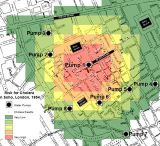
Risk Terrain Modeling (RTM) is a spatial analysis technique used to diagnose environmental conditions that lead to hazardous outcomes. Originally developed for applications to violent crime analysis, RTM is utilized here to analyze Dr. John Snow’s data from the 1854 cholera outbreak in London to demonstrate its potential value to contemporary epidemiological investigations. Dr. Snow saved countless lives when he traced the source of the cholera outbreak to a specific water pump through inductive reasoning, which he communicated through maps and spatial evidence. His methods have since inspired several fields of scientific inquiry. Informed by the extant research on RTM, we speculated that it could have helped test Dr. Snow’s hypothesis about cholera and empirically identified the sole source of contaminated well water. We learned that it could and, although it was not available to Dr. Snow in the 1800s, we discuss RTM’s implications for present-day research and practice as it relates to the analysis, prevention and treatment of cholera and other public health threats around the world.
中文翻译:
1854年伦敦苏活区的霍乱死亡:流行病学调查的风险地形建模。
风险地形建模(RTM)是一种空间分析技术,用于诊断导致危险结果的环境条件。RTM最初是为暴力犯罪分析应用开发的,在这里用于分析John Snow博士从1854年伦敦霍乱爆发中获得的数据,以证明其对当代流行病学调查的潜在价值。Snow博士通过归纳推理追踪霍乱爆发的源头到特定的水泵,挽救了无数生命,他通过地图和空间证据进行了交流。此后,他的方法激发了科学探索的多个领域。根据对RTM的现有研究的了解,我们推测它可以帮助检验Snow博士关于霍乱的假设,并凭经验确定污染的井水的唯一来源。我们了解到它可以并且


 京公网安备 11010802027423号