当前位置:
X-MOL 学术
›
Sci. Total Environ.
›
论文详情
Our official English website, www.x-mol.net, welcomes your
feedback! (Note: you will need to create a separate account there.)
A multi-city air pollution population exposure study: Combined use of chemical-transport and random-Forest models with dynamic population data.
Science of the Total Environment ( IF 8.2 ) Pub Date : 2020-03-26 , DOI: 10.1016/j.scitotenv.2020.138102 Claudio Gariazzo 1 , Giuseppe Carlino 2 , Camillo Silibello 3 , Matteo Renzi 4 , Sandro Finardi 3 , Nicola Pepe 3 , Paola Radice 3 , Francesco Forastiere 5 , Paola Michelozzi 4 , Giovanni Viegi 6 , Massimo Stafoggia 4 ,
Science of the Total Environment ( IF 8.2 ) Pub Date : 2020-03-26 , DOI: 10.1016/j.scitotenv.2020.138102 Claudio Gariazzo 1 , Giuseppe Carlino 2 , Camillo Silibello 3 , Matteo Renzi 4 , Sandro Finardi 3 , Nicola Pepe 3 , Paola Radice 3 , Francesco Forastiere 5 , Paola Michelozzi 4 , Giovanni Viegi 6 , Massimo Stafoggia 4 ,
Affiliation
|
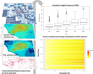
Cities are severely affected by air pollution. Local emissions and urban structures can produce large spatial heterogeneities. We aim to improve the estimation of NO2, O3, PM2.5 and PM10 concentrations in 6 Italian metropolitan areas, using chemical-transport and machine learning models, and to assess the effect on population exposure by using information on urban population mobility. Three years (2013-2015) of simulations were performed by the Chemical-Transport Model (CTM) FARM, at 1 km resolution, fed by boundary conditions provided by national-scale simulations, local emission inventories and meteorological fields. A downscaling of daily air pollutants at higher resolution (200 m) was then carried out by means of a machine learning Random-Forest (RF) model, considering CTM and spatial-temporal predictors, such as population, land-use, surface greenness and vehicular traffic, as input. RF achieved mean cross-validation (CV) R2 of 0.59, 0.72, 0.76 and 0.75 for NO2, PM10, PM2.5 and O3, respectively, improving results from CTM alone. Mean concentration fields exhibited clear geographical gradients caused by climate conditions, local emission sources and photochemical processes. Time series of population weighted exposure (PWE) were estimated for two months of the year 2015 and for five cities, by combining population mobility data (derived from mobile phone traffic volumes data), and concentration levels from the RF model. PWE_RF metric better approximated the observed concentrations compared with the predictions from either CTM alone or CTM and RF combined, especially for pollutants exhibiting strong spatial gradients, such as NO2. 50% of the population was estimated to be exposed to NO2 concentrations between 12 and 38 μg/m3 and PM10 between 20 and 35 μg/m3. This work supports the potential of machine learning methods in predicting air pollutant levels in urban areas at high spatial and temporal resolutions.
中文翻译:

一项多城市空气污染人口暴露研究:结合使用化学运输模型和随机森林模型与动态人口数据。
城市受到空气污染的严重影响。局部排放和城市结构会产生很大的空间异质性。我们旨在使用化学运输和机器学习模型改善意大利6个大都市地区NO2,O3,PM2.5和PM10浓度的估算,并通过使用有关城市人口流动性的信息来评估对人口暴露的影响。由化学运输模型(CTM)FARM以1 km的分辨率进行了三年(2013-2015)的模拟,由国家规模模拟,本地排放清单和气象领域提供的边界条件进行模拟。然后,通过机器学习随机森林(RF)模型,在考虑了CTM和时空预测因素(例如人口,土地利用,作为输入,地面绿度和车辆流量。RF对NO2,PM10,PM2.5和O3的平均交叉验证(CV)R2分别为0.59、0.72、0.76和0.75,改善了仅CTM的结果。平均浓度场表现出由气候条件,局部排放源和光化学过程引起的清晰的地理梯度。通过结合人口流动性数据(来自手机流量数据)和RF模型的集中度,估计了2015年两个月和五个城市的人口加权暴露(PWE)时间序列。与单独的CTM或CTM和RF的预测相比,PWE_RF度量更好地近似了观测到的浓度,尤其是对于表现出强空间梯度的污染物(例如NO2)而言。估计有50%的人口暴露于12至38μg/ m3的NO2浓度和20至35μg/ m3的PM10。这项工作支持了机器学习方法在高时空分辨率下预测城市地区空气污染物水平的潜力。
更新日期:2020-03-27
中文翻译:
一项多城市空气污染人口暴露研究:结合使用化学运输模型和随机森林模型与动态人口数据。
城市受到空气污染的严重影响。局部排放和城市结构会产生很大的空间异质性。我们旨在使用化学运输和机器学习模型改善意大利6个大都市地区NO2,O3,PM2.5和PM10浓度的估算,并通过使用有关城市人口流动性的信息来评估对人口暴露的影响。由化学运输模型(CTM)FARM以1 km的分辨率进行了三年(2013-2015)的模拟,由国家规模模拟,本地排放清单和气象领域提供的边界条件进行模拟。然后,通过机器学习随机森林(RF)模型,在考虑了CTM和时空预测因素(例如人口,土地利用,作为输入,地面绿度和车辆流量。RF对NO2,PM10,PM2.5和O3的平均交叉验证(CV)R2分别为0.59、0.72、0.76和0.75,改善了仅CTM的结果。平均浓度场表现出由气候条件,局部排放源和光化学过程引起的清晰的地理梯度。通过结合人口流动性数据(来自手机流量数据)和RF模型的集中度,估计了2015年两个月和五个城市的人口加权暴露(PWE)时间序列。与单独的CTM或CTM和RF的预测相比,PWE_RF度量更好地近似了观测到的浓度,尤其是对于表现出强空间梯度的污染物(例如NO2)而言。估计有50%的人口暴露于12至38μg/ m3的NO2浓度和20至35μg/ m3的PM10。这项工作支持了机器学习方法在高时空分辨率下预测城市地区空气污染物水平的潜力。


 京公网安备 11010802027423号