当前位置:
X-MOL 学术
›
Remote Sens. Environ.
›
论文详情
Our official English website, www.x-mol.net, welcomes your
feedback! (Note: you will need to create a separate account there.)
Hyperlocal mapping of urban air temperature using remote sensing and crowdsourced weather data
Remote Sensing of Environment ( IF 11.1 ) Pub Date : 2020-06-01 , DOI: 10.1016/j.rse.2020.111791 Zander S. Venter , Oscar Brousse , Igor Esau , Fred Meier
Remote Sensing of Environment ( IF 11.1 ) Pub Date : 2020-06-01 , DOI: 10.1016/j.rse.2020.111791 Zander S. Venter , Oscar Brousse , Igor Esau , Fred Meier
|
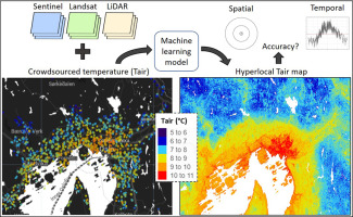
Abstract The impacts of climate change such as extreme heat waves are exacerbated in cities where most of the world's population live. Quantifying urbanization impacts on ambient air temperatures (Tair) has relevance for human health risk, building energy use efficiency, vector-borne disease control and urban biodiversity. Remote sensing of urban climate has been focused on land surface temperature (LST) due to a scarcity of data on Tair which is usually interpolated at 1 km resolution. We assessed the efficacy of mapping hyperlocal Tair (spatial resolutions of 10–30 m) over Oslo, Norway, by integrating Sentinel, Landsat and LiDAR data with crowd-sourced Tair measurements from 1310 private weather stations during 2018. Using Random Forest regression modelling, we found that annual mean, daily maximum and minimum Tair can be mapped with an average RMSE of 0.52 °C (R2 = 0.5), 1.85 °C (R2 = 0.05) and 1.46 °C (R2 = 0.33), respectively. Mapping accuracy decreased sharply with
中文翻译:

使用遥感和众包天气数据绘制城市气温的超局部地图
摘要 极端热浪等气候变化的影响在世界上大多数人口居住的城市中加剧。量化城市化对环境气温 (Tair) 的影响与人类健康风险、建筑能源利用效率、病媒传播疾病控制和城市生物多样性相关。由于缺乏 Tair 数据,通常以 1 公里的分辨率进行插值,因此城市气候的遥感一直集中在地表温度 (LST) 上。我们通过将 Sentinel、Landsat 和 LiDAR 数据与 2018 年期间 1310 个私人气象站的众包 Tair 测量值相结合,评估了在挪威奥斯陆绘制超局部 Tair(空间分辨率为 10-30 m)的效果。我们发现年均值 每日最高和最低 Tair 可以分别以 0.52 °C (R2 = 0.5)、1.85 °C (R2 = 0.05) 和 1.46 °C (R2 = 0.33) 的平均 RMSE 绘制。制图精度急剧下降
更新日期:2020-06-01
中文翻译:
使用遥感和众包天气数据绘制城市气温的超局部地图
摘要 极端热浪等气候变化的影响在世界上大多数人口居住的城市中加剧。量化城市化对环境气温 (Tair) 的影响与人类健康风险、建筑能源利用效率、病媒传播疾病控制和城市生物多样性相关。由于缺乏 Tair 数据,通常以 1 公里的分辨率进行插值,因此城市气候的遥感一直集中在地表温度 (LST) 上。我们通过将 Sentinel、Landsat 和 LiDAR 数据与 2018 年期间 1310 个私人气象站的众包 Tair 测量值相结合,评估了在挪威奥斯陆绘制超局部 Tair(空间分辨率为 10-30 m)的效果。我们发现年均值 每日最高和最低 Tair 可以分别以 0.52 °C (R2 = 0.5)、1.85 °C (R2 = 0.05) 和 1.46 °C (R2 = 0.33) 的平均 RMSE 绘制。制图精度急剧下降


 京公网安备 11010802027423号