当前位置:
X-MOL 学术
›
Sci. Total Environ.
›
论文详情
Our official English website, www.x-mol.net, welcomes your
feedback! (Note: you will need to create a separate account there.)
Understanding the factors associated with long-term reconstructed turbidity in Lake Diefenbaker from Landsat-imagery.
Science of the Total Environment ( IF 8.2 ) Pub Date : 2020-03-25 , DOI: 10.1016/j.scitotenv.2020.138222 Oghenemise Abirhire 1 , John-Mark Davies 2 , Xulin Guo 3 , Jeff Hudson 1
Science of the Total Environment ( IF 8.2 ) Pub Date : 2020-03-25 , DOI: 10.1016/j.scitotenv.2020.138222 Oghenemise Abirhire 1 , John-Mark Davies 2 , Xulin Guo 3 , Jeff Hudson 1
Affiliation
|
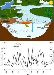
Turbidity affects a variety of aquatic ecosystem processes. Turbidity events are dominated by suspended sediment in many systems. High levels of suspended sediment in lakes can occur during periods of high inflows from turbid tributaries or suspension of sediment from lake beds. This study reconstructed historic turbidity levels using Landsat-imagery on Lake Diefenbaker (LD), a large river-reservoir constructed in the late 1960's on the naturally turbid South Saskatchewan River (SSR). We examined the factors that were associated with it. Reconstructed turbidity levels, from Landsat-images, were similar to actual turbidity. The SSR flow and wind speed explained 64%, 54% and 69% of the variability in estimated turbidity levels at the riverine zone, the transition zone and the entire reservoir, respectively. The decrease in estimated turbidity from June to October and down the length of the reservoir is likely associated with the decline in the SSR flow and the settling of suspended sediments. The relationship between estimated turbidity and wind speed may be associated with the re-suspension of bottom sediment at the upper reach of LD. Wind speed and direction were related to estimated turbidity at the lacustrine zone (r2adj = 0.19, P < 0.05), which may be attributed to the persistence of sediments. We observed high turbidity in 2002 that exceeded other estimates of turbidity. Since 2002 was preceded by a prolonged drought, the high estimate turbidity may be related to an increase in sediment loads from the SSR flow and an increase in shoreline erosion from a rise in LD's water level. Hence, extreme events (drought and flooding) are associated with high turbidity in LD. As the Canadian Prairies continues to undergo climate change, lakes located in this region are predicted to experience more frequent extreme events. These extreme events will cause further deterioration of water quality.
中文翻译:

从Landsat影像了解Diefenbaker湖中长期重建浊度的相关因素。
浊度影响各种水生生态系统过程。在许多系统中,浊度事件以悬浮的沉积物为主。浑浊的支流大量涌入或湖床沉积物悬浮时,湖泊中的悬浮物含量高。这项研究使用了位于迪芬贝克湖(LD)上的Landsat影像重建了历史浊度水平,该湖是1960年代后期在自然浑浊的南萨斯喀彻温河(SSR)上建造的大型河流水库。我们检查了与之相关的因素。从Landsat图像中重建的浊度水平与实际的浊度相似。SSR的流量和风速分别解释了河流带,过渡带和整个水库的浊度估算值的64%,54%和69%。6月至10月估计浊度的减少以及水库长度的减少可能与SSR流量的减少和悬浮沉积物的沉降有关。估计浊度和风速之间的关系可能与LD上游河段底部沉积物的重新悬浮有关。风速和风向与湖区估计的浊度有关(r2adj = 0.19,P <0.05),这可能归因于沉积物的持久性。我们在2002年观察到高浊度,超过了其他浊度估计值。自2002年干旱持续以来,高估计的浊度可能与SSR流量增加的泥沙负荷和LD的水位上升引起的海岸线侵蚀增加有关。因此,极端事件(干旱和洪水)与LD的高浊度有关。随着加拿大大草原继续遭受气候变化的影响,预计该地区的湖泊将经历更频繁的极端事件。这些极端事件将导致水质进一步恶化。
更新日期:2020-03-26
中文翻译:
从Landsat影像了解Diefenbaker湖中长期重建浊度的相关因素。
浊度影响各种水生生态系统过程。在许多系统中,浊度事件以悬浮的沉积物为主。浑浊的支流大量涌入或湖床沉积物悬浮时,湖泊中的悬浮物含量高。这项研究使用了位于迪芬贝克湖(LD)上的Landsat影像重建了历史浊度水平,该湖是1960年代后期在自然浑浊的南萨斯喀彻温河(SSR)上建造的大型河流水库。我们检查了与之相关的因素。从Landsat图像中重建的浊度水平与实际的浊度相似。SSR的流量和风速分别解释了河流带,过渡带和整个水库的浊度估算值的64%,54%和69%。6月至10月估计浊度的减少以及水库长度的减少可能与SSR流量的减少和悬浮沉积物的沉降有关。估计浊度和风速之间的关系可能与LD上游河段底部沉积物的重新悬浮有关。风速和风向与湖区估计的浊度有关(r2adj = 0.19,P <0.05),这可能归因于沉积物的持久性。我们在2002年观察到高浊度,超过了其他浊度估计值。自2002年干旱持续以来,高估计的浊度可能与SSR流量增加的泥沙负荷和LD的水位上升引起的海岸线侵蚀增加有关。因此,极端事件(干旱和洪水)与LD的高浊度有关。随着加拿大大草原继续遭受气候变化的影响,预计该地区的湖泊将经历更频繁的极端事件。这些极端事件将导致水质进一步恶化。


 京公网安备 11010802027423号