当前位置:
X-MOL 学术
›
PLOS Negl. Trop. Dis.
›
论文详情
Our official English website, www.x-mol.net, welcomes your
feedback! (Note: you will need to create a separate account there.)
Quantifying geographic accessibility to improve efficiency of entomological monitoring.
PLOS Neglected Tropical Diseases ( IF 3.4 ) Pub Date : 2020-03-23 , DOI: 10.1371/journal.pntd.0008096 Joshua Longbottom 1, 2 , Ana Krause 1 , Stephen J Torr 1 , Michelle C Stanton 1, 2
PLOS Neglected Tropical Diseases ( IF 3.4 ) Pub Date : 2020-03-23 , DOI: 10.1371/journal.pntd.0008096 Joshua Longbottom 1, 2 , Ana Krause 1 , Stephen J Torr 1 , Michelle C Stanton 1, 2
Affiliation
|
BACKGROUND
Vector-borne diseases are important causes of mortality and morbidity in humans and livestock, particularly for poorer communities and countries in the tropics. Large-scale programs against these diseases, for example malaria, dengue and African trypanosomiasis, include vector control, and assessing the impact of this intervention requires frequent and extensive monitoring of disease vector abundance. Such monitoring can be expensive, especially in the later stages of a successful program where numbers of vectors and cases are low.
METHODOLOGY/PRINCIPAL FINDINGS
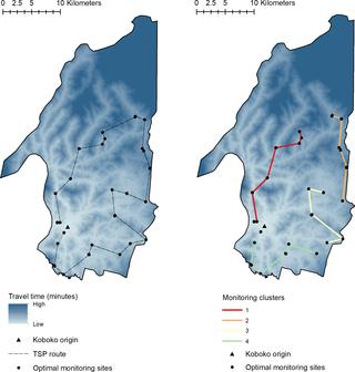
We developed a system that allows the identification of monitoring sites where pre-intervention densities of vectors are predicted to be high, and travel cost to sites is low, highlighting the most efficient locations for longitudinal monitoring. Using remotely sensed imagery and an image classification algorithm, we mapped landscape resistance associated with on- and off-road travel for every gridded location (3m and 0.5m grid cells) within Koboko district, Uganda. We combine the accessibility surface with pre-existing estimates of tsetse abundance and propose a stratified sampling approach to determine the most efficient locations for longitudinal data collection. Our modelled predictions were validated against empirical measurements of travel-time and existing maps of road networks. We applied this approach in northern Uganda where a large-scale vector control program is being implemented to control human African trypanosomiasis, a neglected tropical disease (NTD) caused by trypanosomes transmitted by tsetse flies. Our accessibility surfaces indicate a high performance when compared to empirical data, with remote sensing identifying a further ~70% of roads than existing networks.
CONCLUSIONS/SIGNIFICANCE
By integrating such estimates with predictions of tsetse abundance, we propose a methodology to determine the optimal placement of sentinel monitoring sites for evaluating control programme efficacy, moving from a nuanced, ad-hoc approach incorporating intuition, knowledge of vector ecology and local knowledge of geographic accessibility, to a reproducible, quantifiable one.
中文翻译:

量化地理可达性以提高昆虫学监测的效率。
背景技术媒介传播的疾病是人类和牲畜死亡和发病的重要原因,特别是对于热带地区的贫困社区和国家。针对疟疾、登革热和非洲锥虫病等疾病的大规模规划包括病媒控制,评估这种干预措施的影响需要对病媒丰度进行频繁和广泛的监测。这种监测的成本可能很高,尤其是在成功项目的后期阶段,因为媒介和病例数量较少。方法/主要发现 我们开发了一个系统,可以识别预测干预前媒介密度较高且前往站点的旅行成本较低的监测点,突出显示纵向监测最有效的位置。使用遥感图像和图像分类算法,我们绘制了乌干达科博科区内每个网格位置(3m 和 0.5m 网格单元)与公路和越野旅行相关的景观阻力。我们将可达性表面与采采蝇丰度的预先存在的估计相结合,并提出了一种分层采样方法来确定纵向数据收集的最有效位置。我们的模型预测根据旅行时间和现有道路网络地图的经验测量进行了验证。我们在乌干达北部应用了这种方法,那里正在实施大规模病媒控制计划,以控制人类非洲锥虫病,这是一种由采采蝇传播的锥虫引起的被忽视的热带病 (NTD)。与经验数据相比,我们的可达性表面显示出较高的性能,遥感比现有网络进一步识别了约 70% 的道路。结论/意义 通过将这些估计与采采蝇丰度的预测相结合,我们提出了一种方法来确定哨点监测点的最佳位置,以评估控制计划的有效性,从一种细致入微的、临时的方法,结合直觉、病媒生态学知识和当地的知识。对地理可达性的了解,使其成为可重复的、可量化的知识。
更新日期:2020-03-24
中文翻译:
量化地理可达性以提高昆虫学监测的效率。
背景技术媒介传播的疾病是人类和牲畜死亡和发病的重要原因,特别是对于热带地区的贫困社区和国家。针对疟疾、登革热和非洲锥虫病等疾病的大规模规划包括病媒控制,评估这种干预措施的影响需要对病媒丰度进行频繁和广泛的监测。这种监测的成本可能很高,尤其是在成功项目的后期阶段,因为媒介和病例数量较少。方法/主要发现 我们开发了一个系统,可以识别预测干预前媒介密度较高且前往站点的旅行成本较低的监测点,突出显示纵向监测最有效的位置。使用遥感图像和图像分类算法,我们绘制了乌干达科博科区内每个网格位置(3m 和 0.5m 网格单元)与公路和越野旅行相关的景观阻力。我们将可达性表面与采采蝇丰度的预先存在的估计相结合,并提出了一种分层采样方法来确定纵向数据收集的最有效位置。我们的模型预测根据旅行时间和现有道路网络地图的经验测量进行了验证。我们在乌干达北部应用了这种方法,那里正在实施大规模病媒控制计划,以控制人类非洲锥虫病,这是一种由采采蝇传播的锥虫引起的被忽视的热带病 (NTD)。与经验数据相比,我们的可达性表面显示出较高的性能,遥感比现有网络进一步识别了约 70% 的道路。结论/意义 通过将这些估计与采采蝇丰度的预测相结合,我们提出了一种方法来确定哨点监测点的最佳位置,以评估控制计划的有效性,从一种细致入微的、临时的方法,结合直觉、病媒生态学知识和当地的知识。对地理可达性的了解,使其成为可重复的、可量化的知识。


 京公网安备 11010802027423号