当前位置:
X-MOL 学术
›
Land Use Policy
›
论文详情
Our official English website, www.x-mol.net, welcomes your
feedback! (Note: you will need to create a separate account there.)
Implications of land use transitions and climate change on local flooding in urban areas: An assessment of 42 Indian cities
Land Use Policy ( IF 6.0 ) Pub Date : 2020-06-01 , DOI: 10.1016/j.landusepol.2020.104571 Vidhee Avashia , Amit Garg
Land Use Policy ( IF 6.0 ) Pub Date : 2020-06-01 , DOI: 10.1016/j.landusepol.2020.104571 Vidhee Avashia , Amit Garg
|
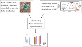
Abstract Urban development induced land transitions affect urban hydrology, resulting in increased flooding risks. Climate change-related precipitation changes are an added complexity to the flood risks of cities. This study examines the role of land use changes in determining the occurrence of urban flooding events across 42 Indian cities under current and future climate change scenarios. Landsat images for 1990, 2000, 2010, and 2017 have been processed using a hybrid classification technique to determine the land use shares for all cities. A typical event-count study using newspaper archives has been conducted to create a flooding event database. A multilevel model employing logistic mixed-effects approach was used. Future projections of the occurrence of flooding events for nine models under three climate change-related Representative Concentration Pathways (RCPs)—2.6, 4.5, and 8.5—and three urban development scenarios have been carried out. The results suggest that cities should preserve the land uses that act as a sponge—the green, open and blue spaces. As these spaces decrease, the projected flooding events increase. Under the RCP 2.6 scenario, the number of flooding events is significantly lower (95 % confidence) than under RCPs 4.5 and 8.5. The expected flooding occurrences between RCP4.5 and RCP8.5 are not significantly different (95 % confidence) for many scenarios, suggesting that Indian cities should aim for a world temperature increase of below 2 °C, or devastating consequences are imminent. This study highlights the need for Indian cities to undertake integrated spatial planning measures for a resilient, sustainable urban future.
中文翻译:

土地利用转变和气候变化对城市地区局部洪水的影响:对 42 个印度城市的评估
摘要 城市发展引起的土地转型影响城市水文,导致洪水风险增加。与气候变化相关的降水变化增加了城市洪水风险的复杂性。本研究考察了土地利用变化在确定当前和未来气候变化情景下 42 个印度城市城市洪水事件发生中的作用。1990 年、2000 年、2010 年和 2017 年的 Landsat 影像已使用混合分类技术进行处理,以确定所有城市的土地利用份额。使用报纸档案进行了典型的事件计数研究,以创建洪水事件数据库。使用了采用逻辑混合效应方法的多级模型。已经对三个与气候变化相关的代表性浓度路径 (RCP)——2.6、4.5 和 8.5——以及三个城市发展情景下的九个模型的洪水事件发生进行了未来预测。结果表明,城市应该保护作为海绵的土地用途——绿色、开放和蓝色空间。随着这些空间的减少,预计的洪水事件会增加。在 RCP 2.6 情景下,洪水事件的数量(95% 置信度)明显低于 RCP 4.5 和 8.5。在许多情况下,RCP4.5 和 RCP8.5 之间的预期洪水发生率没有显着差异(95% 置信度),这表明印度城市应将世界温度升高目标定为 2°C 以下,否则毁灭性后果即将来临。
更新日期:2020-06-01
中文翻译:
土地利用转变和气候变化对城市地区局部洪水的影响:对 42 个印度城市的评估
摘要 城市发展引起的土地转型影响城市水文,导致洪水风险增加。与气候变化相关的降水变化增加了城市洪水风险的复杂性。本研究考察了土地利用变化在确定当前和未来气候变化情景下 42 个印度城市城市洪水事件发生中的作用。1990 年、2000 年、2010 年和 2017 年的 Landsat 影像已使用混合分类技术进行处理,以确定所有城市的土地利用份额。使用报纸档案进行了典型的事件计数研究,以创建洪水事件数据库。使用了采用逻辑混合效应方法的多级模型。已经对三个与气候变化相关的代表性浓度路径 (RCP)——2.6、4.5 和 8.5——以及三个城市发展情景下的九个模型的洪水事件发生进行了未来预测。结果表明,城市应该保护作为海绵的土地用途——绿色、开放和蓝色空间。随着这些空间的减少,预计的洪水事件会增加。在 RCP 2.6 情景下,洪水事件的数量(95% 置信度)明显低于 RCP 4.5 和 8.5。在许多情况下,RCP4.5 和 RCP8.5 之间的预期洪水发生率没有显着差异(95% 置信度),这表明印度城市应将世界温度升高目标定为 2°C 以下,否则毁灭性后果即将来临。


 京公网安备 11010802027423号