当前位置:
X-MOL 学术
›
Landsc. Urban Plan.
›
论文详情
Our official English website, www.x-mol.net, welcomes your
feedback! (Note: you will need to create a separate account there.)
Messy maps: Qualitative GIS representations of resilience
Landscape and Urban Planning ( IF 7.9 ) Pub Date : 2020-06-01 , DOI: 10.1016/j.landurbplan.2020.103771 Faith E. Taylor , James D.A. Millington , Ezekiel Jacob , Bruce D. Malamud , Mark Pelling
Landscape and Urban Planning ( IF 7.9 ) Pub Date : 2020-06-01 , DOI: 10.1016/j.landurbplan.2020.103771 Faith E. Taylor , James D.A. Millington , Ezekiel Jacob , Bruce D. Malamud , Mark Pelling
|
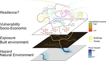
Abstract To include qualitative aspects of flood resilience, such as emotion, social connections and experience, into urban planning, we present a methodology incorporating innovative and experimental map visualisations of informal settlements. The concept of resilience in urban planning is often deployed in technocratic ways using quantitative tools such as geographic information systems (GIS). Yet in the urban Global South, where high proportions of the population live in informal settlements, the knowledge infrastructures used by public authorities leave little room for participation and consideration of local experience. We outline arts-based workshop activities and a qualitative GIS methodology to map resilience as defined by informal settlement residents in two case study cities, Nairobi (Kenya) and Cape Town (South Africa), with applicability across the urban Global South. For each city, four map layers were generated: (i) flood footprints showing resident’s spatial knowledge of floods; (ii) georeferenced, narrated 360° photo spheres capturing different perspectives about a space; (iii) spatial social network maps showing residents connections to formal and informal actors before/during floods; (iv) multimedia pop-ups communicating contextual details missing from traditional GIS maps. We show how these prototype maps can be integrated within planning knowledge infrastructures. For spatially imprecise qualitative aspects of resilience in informal settlements, placing markers on a map makes them visible in ways that planners can begin to engage with. Although challenges remain, we found openness in Nairobi and Cape Town by city-level actors to use qualitative forms of evidence, and that the contextual detail aided their retention and understanding of resilience.
中文翻译:

凌乱的地图:弹性的定性 GIS 表示
摘要 为了将抗洪能力的定性方面(例如情感、社会联系和经验)纳入城市规划,我们提出了一种方法,该方法结合了非正规住区的创新和实验性地图可视化。城市规划中的复原力概念通常使用地理信息系统 (GIS) 等定量工具以技术专家的方式进行部署。然而,在城市全球南方,大量人口居住在非正式住区,公共当局使用的知识基础设施几乎没有留下参与和考虑当地经验的空间。我们概述了基于艺术的研讨会活动和定性 GIS 方法,以绘制由两个案例研究城市内罗毕(肯尼亚)和开普敦(南非)的非正式住区居民定义的弹性,适用于全球南方城市。对于每个城市,生成了四个地图层:(i) 洪水足迹,显示居民对洪水的空间知识;(ii) 地理参考、叙述的 360° Photo Sphere 照片捕捉关于空间的不同视角;(iii) 空间社交网络地图,显示洪水之前/期间居民与正式和非正式参与者的联系;(iv) 多媒体弹出窗口,传达传统 GIS 地图中缺失的上下文细节。我们展示了如何将这些原型地图集成到规划知识基础设施中。对于非正式住区弹性在空间上不精确的定性方面,在地图上放置标记会使它们以规划者可以开始参与的方式可见。尽管挑战依然存在,
更新日期:2020-06-01
中文翻译:
凌乱的地图:弹性的定性 GIS 表示
摘要 为了将抗洪能力的定性方面(例如情感、社会联系和经验)纳入城市规划,我们提出了一种方法,该方法结合了非正规住区的创新和实验性地图可视化。城市规划中的复原力概念通常使用地理信息系统 (GIS) 等定量工具以技术专家的方式进行部署。然而,在城市全球南方,大量人口居住在非正式住区,公共当局使用的知识基础设施几乎没有留下参与和考虑当地经验的空间。我们概述了基于艺术的研讨会活动和定性 GIS 方法,以绘制由两个案例研究城市内罗毕(肯尼亚)和开普敦(南非)的非正式住区居民定义的弹性,适用于全球南方城市。对于每个城市,生成了四个地图层:(i) 洪水足迹,显示居民对洪水的空间知识;(ii) 地理参考、叙述的 360° Photo Sphere 照片捕捉关于空间的不同视角;(iii) 空间社交网络地图,显示洪水之前/期间居民与正式和非正式参与者的联系;(iv) 多媒体弹出窗口,传达传统 GIS 地图中缺失的上下文细节。我们展示了如何将这些原型地图集成到规划知识基础设施中。对于非正式住区弹性在空间上不精确的定性方面,在地图上放置标记会使它们以规划者可以开始参与的方式可见。尽管挑战依然存在,


 京公网安备 11010802027423号