当前位置:
X-MOL 学术
›
Comput. Animat. Virtual Worlds
›
论文详情
Our official English website, www.x-mol.net, welcomes your
feedback! (Note: you will need to create a separate account there.)
From 360° camera toward to virtual map app: Designing low‐cost pilot study
Computer Animation and Virtual Worlds ( IF 0.9 ) Pub Date : 2020-03-16 , DOI: 10.1002/cav.1924 Rostislav Netek 1 , Tomas Burian 1 , Martin Macecek 1
Computer Animation and Virtual Worlds ( IF 0.9 ) Pub Date : 2020-03-16 , DOI: 10.1002/cav.1924 Rostislav Netek 1 , Tomas Burian 1 , Martin Macecek 1
Affiliation
|
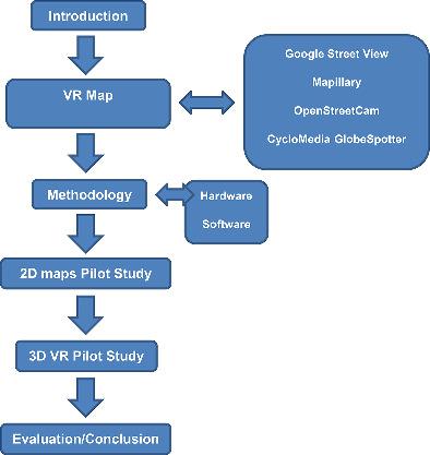
Currently, virtual reality (VR) is a trend both in general and in specific fields such as interactive maps. The article aims to test the possibilities of deployment of low‐cost virtual reality environment for the 3D spatial panoramic application. It discusses and compares modern trends in hardware (panoramic cameras and glasses) and software in the field of virtual reality. Many panoramic map applications (e.g., the well‐known “Google Street View”) allow us to navigate through applications using VR headsets or on an ordinary 2D monitor. The main aim of the article is to design, develop, and deploy VR map application with different levels of user interaction. It presents two pilot studies with different user's interactivity and technical solutions: “simple” 2D‐based map with 360° panoramic photos and “true” 3D application for VR glasses. The article focuses on the possibilities of creating low‐cost map applications. Therefore, the working process “from camera toward to virtual map application” is described as followed‐up case studies.
中文翻译:

从 360° 相机到虚拟地图应用程序:设计低成本试点研究
目前,虚拟现实(VR)无论是在一般领域还是在交互式地图等特定领域都是一种趋势。本文旨在测试为 3D 空间全景应用部署低成本虚拟现实环境的可能性。它讨论和比较了虚拟现实领域硬件(全景相机和眼镜)和软件的现代趋势。许多全景地图应用程序(例如,著名的“谷歌街景”)允许我们使用 VR 耳机或在普通 2D 显示器上浏览应用程序。本文的主要目的是设计、开发和部署具有不同用户交互级别的 VR 地图应用程序。它提出了两个具有不同用户交互性和技术解决方案的试点研究:带有 360° 全景照片的“简单”基于 2D 的地图和 VR 眼镜的“真实”3D 应用程序。本文重点介绍创建低成本地图应用程序的可能性。因此,“从相机到虚拟地图应用”的工作过程被描述为后续案例研究。
更新日期:2020-03-16
中文翻译:
从 360° 相机到虚拟地图应用程序:设计低成本试点研究
目前,虚拟现实(VR)无论是在一般领域还是在交互式地图等特定领域都是一种趋势。本文旨在测试为 3D 空间全景应用部署低成本虚拟现实环境的可能性。它讨论和比较了虚拟现实领域硬件(全景相机和眼镜)和软件的现代趋势。许多全景地图应用程序(例如,著名的“谷歌街景”)允许我们使用 VR 耳机或在普通 2D 显示器上浏览应用程序。本文的主要目的是设计、开发和部署具有不同用户交互级别的 VR 地图应用程序。它提出了两个具有不同用户交互性和技术解决方案的试点研究:带有 360° 全景照片的“简单”基于 2D 的地图和 VR 眼镜的“真实”3D 应用程序。本文重点介绍创建低成本地图应用程序的可能性。因此,“从相机到虚拟地图应用”的工作过程被描述为后续案例研究。


 京公网安备 11010802027423号