Ecological Indicators ( IF 7.0 ) Pub Date : 2020-03-16 , DOI: 10.1016/j.ecolind.2020.106300 Swades Pal , Swapan Talukdar , Ripan Ghosh
|
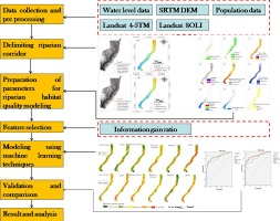
Riparian corridor, a vital ecotonian ecosystem is under stress due to flow reduction and inconsistency of flow in Lower Tangon river basin across the neo tectonically active Barind tract of India and Bangladesh. But it is ill defined and its habitat quality is rarely assessed insipite of its immense socio-ecological importance. The present work intends to delineate the riparian corridor and quality assessment of the riparian habitat in reference to the hydrological alteration (HA) triggered by anthropogenic activities, mainly damming in 1989. The present work applied multi-parametric (altitude, topographic roughness, water body, forest patches) approach for delineating the riparian corridor instead of existing uni-criterion approaches for the same. Quality assessment of the habitat is done using nine surface, ecological, hydrological and anthropogenic parameters in the Arc Gis platform employing advance machine learning algorithms like Fuzzy logic (FL), Artificial Neural Network (ANN), Random Forest (RF), Random subspace, Dagging and Support vector machine (SVM). Total 20.63 km2 and 18.36 km2 areas respectively in pre and post-HA periods alongside the main river are identified as the riparian corridor. HA has reduced the area under the riparian corridor by 12.29% in post-HA state. Simultaneously, the quality of the riparian habitat is also deteriorated in the post-HA period. In pre-HA state, 49.05% area was under good to very good riparian habitat but it is reduced to 11.86% in post-HA state. Regularization of the flood, release of ecological flow to the downstream, renovation of tie channels between flood plain and river, restriction in agricultural invasion towards riparian forest and wetland are some of the essential steps for minimizing qualitative deterioration of riparian habitat and amelioration of the ecosystem concerned.
中文翻译:
筑坝对河岸走廊生境质量的影响
河岸走廊是至关重要的生态系统生态系统,由于印度和孟加拉国新构造活跃的巴林德河下游下坦贡河流域的流量减少和流量不一致而承受压力。但是,由于其巨大的社会生态重要性,它的定义不清,很少评估其栖息地质量。本工作旨在参考人为活动(主要是1989年筑坝)引发的水文变化(HA)来描述河岸走廊和河岸生境的质量评估。本工作应用了多参数(海拔,地形粗糙度,水体) ,森林斑块)来描绘河岸走廊,而不是使用现有的单一标准方法来描绘河岸走廊。使用9个表面,生态学,Arc Gis平台中的水文和人为参数采用先进的机器学习算法,例如模糊逻辑(FL),人工神经网络(ANN),随机森林(RF),随机子空间,拖曳和支持向量机(SVM)。总计20.63 km沿河主干河沿河之前和之后分别有2和18.36 km 2的区域被确定为河岸走廊。在医管局后的州,医管局已将河岸走廊下方的面积减少了12.29%。同时,在HA后期,河岸生境的质量也下降了。在HA前状态下,有49.05%的区域处于良好至非常好的河岸生境,但在HA后状态下则减少到11.86%。洪水的规范化,向下游的生态流量的释放,洪泛平原和河流之间的联系渠道的改造,农业对沿岸森林和湿地的入侵的限制是使沿岸生境的质性恶化和生态系统改善最小化的重要步骤关心。


 京公网安备 11010802027423号