ISPRS Journal of Photogrammetry and Remote Sensing ( IF 12.7 ) Pub Date : 2020-03-03 , DOI: 10.1016/j.isprsjprs.2020.02.019 Collin Homer 1 , Jon Dewitz 1 , Suming Jin 2 , George Xian 1 , Catherine Costello 3 , Patrick Danielson 4 , Leila Gass 5 , Michelle Funk 6 , James Wickham 7 , Stephen Stehman 8 , Roger Auch 1 , Kurt Riitters 9
|
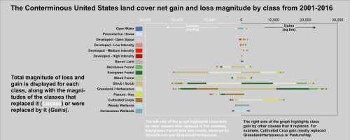
The 2016 National Land Cover Database (NLCD) product suite (available on www.mrlc.gov), includes Landsat-based, 30 m resolution products over the conterminous (CONUS) United States (U.S.) for land cover, urban imperviousness, and tree, shrub, herbaceous and bare ground fractional percentages. The release of NLCD 2016 provides important new information on land change patterns across CONUS from 2001 to 2016. For land cover, seven epochs were concurrently generated for years 2001, 2004, 2006, 2008, 2011, 2013, and 2016. Products reveal that land cover change is significant across most land cover classes and time periods. The land cover product was validated using existing reference data from the legacy NLCD 2011 accuracy assessment, applied to the 2011 epoch of the NLCD 2016 product line. The legacy and new NLCD 2011 overall accuracies were 82% and 83%, respectively, (standard error (SE) was 0.5%), demonstrating a small but significant increase in overall accuracy. Between 2001 and 2016, the CONUS landscape experienced significant change, with almost 8% of the landscape having experienced a land cover change at least once during this period. Nearly 50% of that change involves forest, driven by change agents of harvest, fire, disease and pests that resulted in an overall forest decline, including increasing fragmentation and loss of interior forest. Agricultural change represented 15.9% of the change, with total agricultural spatial extent showing only a slight increase of 4778 km2, however there was a substantial decline (7.94%) in pasture/hay during this time, transitioning mostly to cultivated crop. Water and wetland change comprised 15.2% of change and represent highly dynamic land cover classes from epoch to epoch, heavily influenced by precipitation. Grass and shrub change comprise 14.5% of the total change, with most change resulting from fire. Developed change was the most persistent and permanent land change increase adding almost 29,000 km2 over 15 years (5.6% of total CONUS change), with southern states exhibiting expansion much faster than most of the northern states. Temporal rates of developed change increased in 2001–2006 at twice the rate of 2011–2016, reflecting a slowdown in CONUS economic activity. Future NLCD plans include increasing monitoring frequency, reducing latency time between satellite imaging and product delivery, improving accuracy and expanding the variety of products available in an integrated database.
中文翻译:
来自 2016 年国家土地覆盖数据库的 2001-2016 年美国本土土地覆盖变化模式
2016 年国家土地覆盖数据库 (NLCD) 产品套件(可在 www.mrlc.gov 上获得)包括美国大陆 (CONUS) 上基于 Landsat 的 30 m 分辨率产品,用于土地覆盖、城市不透水性和树木、灌木、草本和裸地分数百分比。NLCD 2016 的发布提供了 2001 年至 2016 年 CONUS 土地变化模式的重要新信息。对于土地覆盖,2001 年、2004 年、2006 年、2008 年、2011 年、2013 年和 2016 年同时生成了七个时期。产品显示土地覆盖在大多数土地覆盖类别和时间段内,覆盖变化是显着的。土地覆盖产品使用来自传统 NLCD 2011 精度评估的现有参考数据进行了验证,适用于 NLCD 2016 产品线的 2011 年。传统和新的 NLCD 2011 总体准确度分别为 82% 和 83%(标准误差 (SE) 为 0.5%),表明总体准确度略有提高。2001 年至 2016 年间,美国本土景观经历了重大变化,近 8% 的景观在此期间至少经历了一次土地覆盖变化。近 50% 的变化涉及森林,由收获、火灾、疾病和害虫等变化因素驱动,导致森林整体衰退,包括日益破碎的内部森林和损失。农业变化占变化的 15.9%,农业总空间范围仅略有增加 4778 km CONUS 景观经历了重大变化,在此期间,近 8% 的景观至少经历了一次土地覆被变化。近 50% 的变化涉及森林,由收获、火灾、疾病和害虫等变化因素驱动,导致森林整体衰退,包括日益破碎的内部森林和损失。农业变化占变化的 15.9%,农业总空间范围仅略有增加 4778 km CONUS 景观经历了重大变化,在此期间,近 8% 的景观至少经历了一次土地覆被变化。近 50% 的变化涉及森林,由收获、火灾、疾病和害虫等变化因素驱动,导致森林整体衰退,包括日益破碎的内部森林和损失。农业变化占变化的 15.9%,农业总空间范围仅略有增加 4778 km2,但在此期间牧场/干草大幅下降(7.94%),主要转向耕作作物。水和湿地变化占变化的 15.2%,代表了从一个时代到另一个时代的高度动态的土地覆盖类别,受降水的影响很大。草和灌木变化占总变化的 14.5%,其中大部分变化是由火灾引起的。发达变化是最持久和永久的土地变化增加,增加了近 29,000 平方公里2超过 15 年(占美国大陆总变化的 5.6%),南部各州的扩张速度远快于大多数北部州。2001-2006 年发达变化的时间增长率是 2011-2016 年的两倍,反映了美国本土经济活动的放缓。未来的 NLCD 计划包括增加监测频率、减少卫星成像和产品交付之间的延迟时间、提高准确性和扩展集成数据库中可用的产品种类。


 京公网安备 11010802027423号