当前位置:
X-MOL 学术
›
Gondwana Res.
›
论文详情
Our official English website, www.x-mol.net, welcomes your
feedback! (Note: you will need to create a separate account there.)
Detrital zircon U Pb geochronology of the Wuyu (Oiyug) Basin, southern Tibetan Plateau, and its geological implications
Gondwana Research ( IF 7.2 ) Pub Date : 2020-07-01 , DOI: 10.1016/j.gr.2020.01.017 Wei Feng , Qingquan Meng , Chunhui Song , Xiaomin Fang , Ruohan Huang , Pengju He , Ying Feng , Shuo Chen , Zhenxing Xing , Daichun Wang
Gondwana Research ( IF 7.2 ) Pub Date : 2020-07-01 , DOI: 10.1016/j.gr.2020.01.017 Wei Feng , Qingquan Meng , Chunhui Song , Xiaomin Fang , Ruohan Huang , Pengju He , Ying Feng , Shuo Chen , Zhenxing Xing , Daichun Wang
|
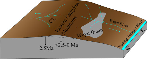
Abstract Cenozoic strata in the Wuyu Basin record the tectonic evolution of the southern Tibetan Plateau. Here, we use detrital zircon isotope data and paleocurrents based on petrographic and sedimentary facies analyses to constrain the provenance of sediments in the Wuyu Basin. On this basis, we recognize multiple phases of tectonic activity in the southern Tibetan Plateau since the Miocene. Tectonic activity at ca. 15 Ma ended the lacustrine sedimentary facies of the Mangxiang Fm. and caused volcanic eruptions; the Wuyu Basin received deposits of the Laiqing Fm. dominated by volcanic and pyroclastic rocks. Tectonic activity at ca. 8 Ma resulted in the volcanic and pyroclastic rocks of the Laiqing Fm. becoming one of the main provenances for the overlying Wuyu Fm. The lacustrine environment in the Wuyu Basin ended again and shifted to braided river sedimentation, the paleocurrent directions changed from northward to southward, and the central Lhasa subterrane became one of the main provenances at ca. 2.5 Ma. By comparing the detrital zircon ages of our samples in the Wuyu Basin and sands from the Lhasa River, we infer that a long river comparable to the modern Lhasa River existed in the Wuyu Basin area at ca. 2.5 Ma. During the Quaternary, due to the consistent convergence between the Indian and Eurasian plates, the eastern Gangdese Mountains uplifted, which resulted in the blocking of this river and the development of the current geomorphic features in the Wuyu Basin area.
中文翻译:

青藏高原南部乌峪盆地碎屑锆石U Pb年代学及其地质意义
摘要 乌榆盆地新生代地层记录了青藏高原南部的构造演化。在这里,我们使用碎屑锆石同位素数据和基于岩相和沉积相分析的古洋流来限制乌鱼盆地沉积物的物源。在此基础上,我们认识到青藏高原南部自中新世以来的多期构造活动。大约的构造活动。15 Ma结束了芒乡组湖相沉积相。并导致火山爆发;乌榆盆地接收莱庆组矿床。以火山岩和火山碎屑岩为主。大约的构造活动。8 Ma 形成了莱青组火山岩和火山碎屑岩。成为上覆乌鱼组的主要物源之一。乌榆盆地湖相环境再次结束,转为辫状河沉积,古水流方向由北向南转变,拉萨中部地下成为主要物源之一。2.5 马。通过比较乌鱼盆地样品和拉萨河砂岩的碎屑锆石年龄,我们推断乌鱼盆地地区存在一条与现代拉萨河相当的长河。2.5 马。第四纪,由于印度板块与欧亚板块的持续汇聚,冈底斯山脉东部隆升,导致该河流被阻塞,乌鱼盆地地区形成现今地貌特征。拉萨中部地下成为约 10 年的主要产地之一。2.5 马。通过比较乌鱼盆地样品和拉萨河砂岩的碎屑锆石年龄,我们推断乌鱼盆地地区存在一条与现代拉萨河相当的长河。2.5 马。第四纪,由于印度板块与欧亚板块的不断汇聚,导致冈底斯山脉东部隆升,导致该河流被阻塞,乌鱼盆地地区形成现今地貌特征。拉萨中部地下成为约 10 年的主要产地之一。2.5 马。通过比较乌鱼盆地样品和拉萨河砂岩的碎屑锆石年龄,我们推断乌鱼盆地地区存在一条与现代拉萨河相当的长河。2.5 马。第四纪,由于印度板块与欧亚板块的持续汇聚,冈底斯山脉东部隆升,导致该河流被阻塞,乌鱼盆地地区形成现今地貌特征。
更新日期:2020-07-01
中文翻译:
青藏高原南部乌峪盆地碎屑锆石U Pb年代学及其地质意义
摘要 乌榆盆地新生代地层记录了青藏高原南部的构造演化。在这里,我们使用碎屑锆石同位素数据和基于岩相和沉积相分析的古洋流来限制乌鱼盆地沉积物的物源。在此基础上,我们认识到青藏高原南部自中新世以来的多期构造活动。大约的构造活动。15 Ma结束了芒乡组湖相沉积相。并导致火山爆发;乌榆盆地接收莱庆组矿床。以火山岩和火山碎屑岩为主。大约的构造活动。8 Ma 形成了莱青组火山岩和火山碎屑岩。成为上覆乌鱼组的主要物源之一。乌榆盆地湖相环境再次结束,转为辫状河沉积,古水流方向由北向南转变,拉萨中部地下成为主要物源之一。2.5 马。通过比较乌鱼盆地样品和拉萨河砂岩的碎屑锆石年龄,我们推断乌鱼盆地地区存在一条与现代拉萨河相当的长河。2.5 马。第四纪,由于印度板块与欧亚板块的持续汇聚,冈底斯山脉东部隆升,导致该河流被阻塞,乌鱼盆地地区形成现今地貌特征。拉萨中部地下成为约 10 年的主要产地之一。2.5 马。通过比较乌鱼盆地样品和拉萨河砂岩的碎屑锆石年龄,我们推断乌鱼盆地地区存在一条与现代拉萨河相当的长河。2.5 马。第四纪,由于印度板块与欧亚板块的不断汇聚,导致冈底斯山脉东部隆升,导致该河流被阻塞,乌鱼盆地地区形成现今地貌特征。拉萨中部地下成为约 10 年的主要产地之一。2.5 马。通过比较乌鱼盆地样品和拉萨河砂岩的碎屑锆石年龄,我们推断乌鱼盆地地区存在一条与现代拉萨河相当的长河。2.5 马。第四纪,由于印度板块与欧亚板块的持续汇聚,冈底斯山脉东部隆升,导致该河流被阻塞,乌鱼盆地地区形成现今地貌特征。


 京公网安备 11010802027423号