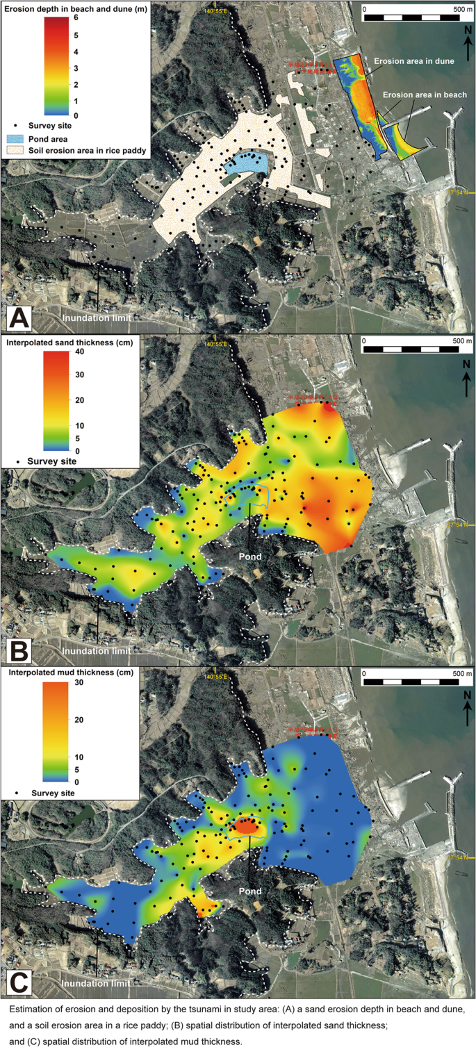
Sedimentary processes and spatial distributions of tsunami deposits in valleys have poorly been understood despite many paleo-tsunami deposits have recently been discovered from sedimentary sequences in valleys. We conducted an exhaustive investigation of 2011 Tohoku-oki tsunami deposits in a narrow valley at the south end of Sendai Plain, northeastern Japan, to collect sedimentological data of the tsunami deposits in the valley and to correlate them with tsunami inundation and associated sedimentary processes. The tsunami deposits were investigated at 174 sites to cover the entire inundation area of the narrow valley. We analyzed thickness, sedimentary structures, and grain size of the tsunami deposits to correlate their spatial variation with tsunami flow hydrodynamics and topographic features. The tsunami deposits, composed of sand and mud layers, were found to be 0–40 cm thick. Sand thickness generally decreased inland with local fluctuation. The sand layer was mostly composed of single unit on the upper main valley and sub-valleys, although it was mainly composed of 2–6 sub-units on the lower main valley and in the pond. Mud thickness is strongly controlled by local sources, namely, the rice paddy and the pond. The depositional area of the mud layer coincides with the distribution of the rice paddies and the pond location. The mud layer also considerably thicker in and around the pond. These results indicate that sediment thickness and sedimentary structures are highly varied on a local scale, but they are generally controlled by local topography. Sediment budget in the valley was estimated, and it may provide implications to general sedimentary process. Total depositional volume of the tsunami sand deposited on land is half of the volume of sediments disappeared from the sandy beach and sand dune, suggesting the rest must have been discharged into the sea by the backwash. Spatial distribution of sediment thickness and sedimentary structures as well as sedimentary processes inferred from 2011 Tohoku-oki tsunami deposits will benefit searching and identification of paleo-tsunami deposits in valleys of other coastal environments.


 京公网安备 11010802027423号