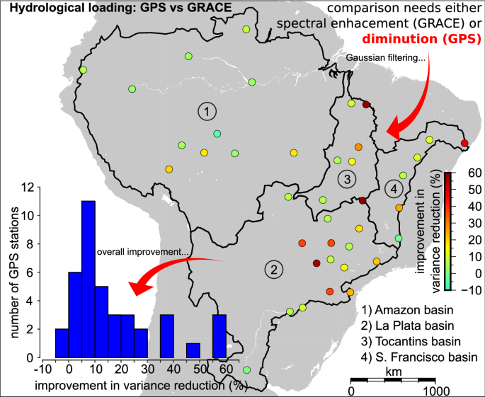
The Global Positioning System (GPS) permanent stations at the equatorial and southern sub-tropical hydrobelts of South America undergo the highest seasonality on the Earth due to hydrological loadings. Fortunately, there are products that account for such variations, although some of them have not been properly evaluated. For instance, global solutions of Gravity Recovery and Climate Experiment (GRACE) are band-limited to lower frequencies; therefore, comparisons with GPS data must account for such spectral inconsistencies. It is proposed to spatially average 39 GPS sites by applying Gaussian smoothing, which allows comparisons with long-wavelength part of GRACE solutions by Center for Space Research (CSR), GeoForschungszentrum, and Jet Propulsion Laboratory. Comparisons are also carried out with loadings from Noah-driven Global Land Data Assimilation System (GLDAS) and GRACE mass concentration (mascon) solution by Goddard Space Flight Center. Results show that CSR best reduces the variances of the radial displacements considering both spatially filtered (70%) and unfiltered (53%) GPS data covering the period from Jan 2010 to Dec 2015. However, GLDAS-Noah underestimates the amplitudes of vertical loadings, which might be due to unmodeled inland water and groundwater storages. While acknowledging that a denser distribution of GPS stations is needed, the findings still shed light on the quality of the global hydrological loading products based on GRACE and GLDAS datasets, which might be of interest to the respective science teams.


 京公网安备 11010802027423号