Our official English website, www.x-mol.net, welcomes your
feedback! (Note: you will need to create a separate account there.)
Estimating Traffic Disruption Patterns with Volunteered Geographic Information.
Scientific Reports ( IF 3.8 ) Pub Date : 2020-01-27 , DOI: 10.1038/s41598-020-57882-2 Chico Q Camargo 1 , Jonathan Bright 1 , Graham McNeill 1 , Sridhar Raman 2 , Scott A Hale 1, 3
Scientific Reports ( IF 3.8 ) Pub Date : 2020-01-27 , DOI: 10.1038/s41598-020-57882-2 Chico Q Camargo 1 , Jonathan Bright 1 , Graham McNeill 1 , Sridhar Raman 2 , Scott A Hale 1, 3
Affiliation
|
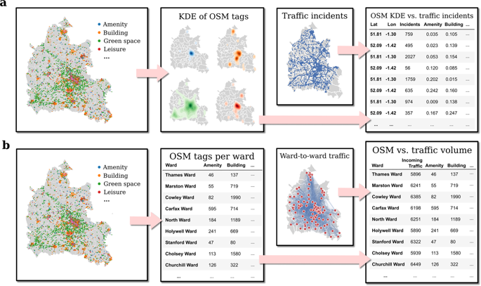
Accurate understanding and forecasting of traffic is a key contemporary problem for policymakers. Road networks are increasingly congested, yet traffic data is often expensive to obtain, making informed policy-making harder. This paper explores the extent to which traffic disruption can be estimated using features from the volunteered geographic information site OpenStreetMap (OSM). We use OSM features as predictors for linear regressions of counts of traffic disruptions and traffic volume at 6,500 points in the road network within 112 regions of Oxfordshire, UK. We show that more than half the variation in traffic volume and disruptions can be explained with OSM features alone, and use cross-validation and recursive feature elimination to evaluate the predictive power and importance of different land use categories. Finally, we show that using OSM's granular point of interest data allows for better predictions than the broader categories typically used in studies of transportation and land use.
中文翻译:

利用自愿的地理信息估计交通中断模式。
对流量的准确理解和预测是决策者当前面临的主要问题。道路网络越来越拥挤,但是交通数据通常很昂贵,这使得制定明智的政策变得更加困难。本文探讨了使用自愿性地理信息网站OpenStreetMap(OSM)的功能可以估算出交通中断的程度。我们使用OSM功能作为英国牛津郡112个地区道路网络中6,500点处交通中断和交通量计数的线性回归的预测变量。我们显示,仅使用OSM功能就可以解释一半以上的交通量变化和交通中断,并使用交叉验证和递归功能消除来评估不同土地利用类别的预测能力和重要性。最后,
更新日期:2020-01-27
中文翻译:
利用自愿的地理信息估计交通中断模式。
对流量的准确理解和预测是决策者当前面临的主要问题。道路网络越来越拥挤,但是交通数据通常很昂贵,这使得制定明智的政策变得更加困难。本文探讨了使用自愿性地理信息网站OpenStreetMap(OSM)的功能可以估算出交通中断的程度。我们使用OSM功能作为英国牛津郡112个地区道路网络中6,500点处交通中断和交通量计数的线性回归的预测变量。我们显示,仅使用OSM功能就可以解释一半以上的交通量变化和交通中断,并使用交叉验证和递归功能消除来评估不同土地利用类别的预测能力和重要性。最后,


 京公网安备 11010802027423号