Catena ( IF 5.4 ) Pub Date : 2020-01-24 , DOI: 10.1016/j.catena.2020.104466 Maria Rosário Fernandes , Francisca C. Aguiar , Maria João Martins , Rui Rivaes , Maria Teresa Ferreira
|
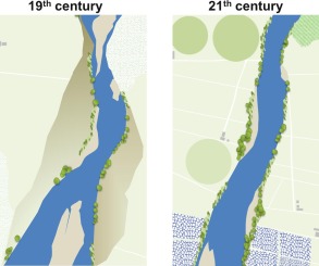
Large rivers on the Iberian Peninsula reflect a long-history of human interventions and natural disturbances in the fluvial corridors and on the surrounding valleys. In this study we aim to characterize the river morphology in pre-regulation times and understand the morphological changes of the large river Tagus (Central Portugal), across space and time. For this, we used comparable military thematic maps from three dates (1855, 1940 and 2000) and evaluated the river landforms, including sinuosity, aquatic, geomorphic and riparian aspects, in three geomorphological zones (Upland, Middle, and Lowland) using a Geographic Information System (GIS). We related the landform variations to the hydrological alterations and to Land-use Land-Cover (hereinafter LULC) changes at valley level. Hydrological data were achieved by simulating river flow regime using the Soil and Water Assessment Tool (SWAT) model. LULC data was obtained by on-screen digitizing of the military thematic maps complemented with ancillary bibliographic information. Metrics for channel form, aquatic and riparian features were quantified in 51 sampling units of 2500 m-long river sections for each period to describe the river morphology. Shannon-Wiener Index (H’) was applied as a descriptor of the morphological diversity.
Data analysis revealed a narrowing of the main channel, an overall reduction of the sinuosity, a smaller number of instream geomorphic units and abandoned lateral channels on the most recent period. Morphological alterations were driven primarily by the reduction of floods and sediment inputs, caused by streamflow regulation, while the agricultural intensification, the augment of forest plantations and the reduction of the Mediterranean scrublands induced changes in sediment dynamics and altered the riparian connectivity. The Upland zone showed the highest morphological alterations switching from a historical high-energy section to a low-dynamic zone. We also observed a high morphological variability in the Middle course exhibiting multifaceted gradients of change, while the Lowland zone reflected continuous but less pronounced modifications. River management planning should express the insights of how past and present human alterations affect morphological processes in river-floodplain systems, particularly taking into account river zones’ specificities and how they may react or constrain potential restoration processes.
中文翻译:
塔霍河的人为长期变化:不同河流区域水文调控和土地利用变化的影响
伊比利亚半岛上的大河反映了人类对河流走廊和周围山谷的人为干预和自然干扰的悠久历史。在这项研究中,我们旨在表征预先调节时期的河流形态,并了解大河Tagus(葡萄牙中部)跨时空分布的形态变化。为此,我们使用了三个日期(1855年,1940年和2000年)的可比军事专题图,并使用地理学评估了三个地貌区(高地,中部和低地)的河流地貌,包括弯曲度,水生,地貌和河岸面。信息系统(GIS)。我们将地形变化与水文变化和谷地土地利用土地覆被(以下简称LULC)的变化联系起来。水文数据是通过使用土壤和水评估工具(SWAT)模型模拟河流流态来获得的。LULC数据是通过对军事主题地图进行数字化并辅以辅助书目信息而获得的。在每个时期的2500 m长河段的51个采样单元中,对河道形式,水生和河岸特征的度量进行了量化,以描述河流的形态。香农-维纳指数(H')被用作形态多样性的描述子。在每个时期以2500 m长的河段的51个采样单位对水生和河岸特征进行量化,以描述河流的形态。香农-维纳指数(H')被用作形态多样性的描述子。在每个时期的2500 m长河段的51个采样单元中,对水生和河岸特征进行了量化,以描述河流的形态。香农-维纳指数(H')被用作形态多样性的描述子。
数据分析显示,在最近时期,主河道变窄,总体弯曲度降低,河内地貌单元数量减少和废弃的侧向河道。形态变化主要是由水流调节引起的洪水和沉积物输入减少所致,而农业集约化,森林种植面积增加和地中海灌丛减少则引起了沉积物动力学变化并改变了河岸联系。高地带表现出最高的形态变化,从历史上的高能区转换为低动力区。我们还观察到,在中游过程中,形态变化很大,呈现出多方面的变化梯度,而低地带则反映出连续但不明显的变化。


 京公网安备 11010802027423号