Catena ( IF 5.4 ) Pub Date : 2020-01-20 , DOI: 10.1016/j.catena.2020.104458 Viet-Ha Nhu , Nhat-Duc Hoang , Hieu Nguyen , Phuong Thao Thi Ngo , Tinh Thanh Bui , Pham Viet Hoa , Pijush Samui , Dieu Tien Bui
|
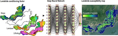
This research aims at investigating the capability of Keras’s deep learning models with three robust optimization algorithms (stochastic gradient descent, root mean square propagation, and adaptive moment optimization) and two-loss functions for spatial modeling of landslide hazard at a regional scale. Shallow landslides at the Ha Long area (Vietnam) were selected as a case study. For this regard, set of ten influencing factors (slope, aspect, curvature, topographic wetness index, landuse, distance to road, distance to river, soil type, distance to fault, and lithology) and 193 landslide polygons were prepared to construct a Geographic Information System (GIS) database for the study area. Using the collected database, the DNN with its potential of realizing complex functional mapping hidden in the data is used to generalize a decision boundary that separates the learning space into two distinct categories: landslide (a positive class) and non-landslide (a negative class). Experimental results point out that the utilized the Keras’s deep learning model with the Adam optimization and the mean squared error lost function is the best with the prediction performance of 84.0%. The performance is better than those of the employed benchmark approaches of random forest, J48 decision tree, classification tree, and logistic model tree. We conclude that the Keras’s deep learning model is a new tool for shallow susceptibility mapping at landslide-prone areas.
中文翻译:
基于Keras深度学习的不同鲁棒优化算法评估热带地区浅层滑坡敏感性的有效性。
这项研究旨在利用三种鲁棒的优化算法(随机梯度下降,均方根传播和自适应矩优化)和两次损失函数来研究Keras深度学习模型在区域规模上进行滑坡灾害空间建模的能力。案例研究选择了下龙地区(越南)的浅层滑坡。为此,准备了十个影响因素(坡度,纵横比,曲率,地形湿度指数,土地利用,到公路的距离,到河的距离,土壤类型,到断层的距离和岩性)和193个滑坡多边形以构成一个地理区域。研究区域的信息系统(GIS)数据库。使用收集的数据库,DNN具有实现隐藏在数据中的复杂功能映射的潜力,用于概括将学习空间分为两个不同类别的决策边界:滑坡(正类)和非滑坡(负类)。实验结果表明,将Keras深度学习模型与Adam优化配合使用,均方误差损失函数是最好的,其预测性能为84.0%。该性能优于随机森林,J48决策树,分类树和逻辑模型树所采用的基准测试方法。我们得出的结论是,Keras的深度学习模型是在滑坡易发地区进行浅层磁化率测绘的新工具。滑坡(正类)和非滑坡(负类)。实验结果表明,将Keras深度学习模型与Adam优化配合使用,均方误差损失函数是最好的,其预测性能为84.0%。该性能优于随机森林,J48决策树,分类树和逻辑模型树所采用的基准测试方法。我们得出的结论是,Keras的深度学习模型是在滑坡易发地区进行浅层磁化率测绘的新工具。滑坡(正类)和非滑坡(负类)。实验结果表明,将Keras深度学习模型与Adam优化配合使用,均方误差损失函数是最好的,其预测性能为84.0%。该性能优于随机森林,J48决策树,分类树和逻辑模型树所采用的基准测试方法。我们得出的结论是,Keras的深度学习模型是在滑坡易发地区进行浅层磁化率测绘的新工具。J48决策树,分类树和逻辑模型树。我们得出的结论是,Keras的深度学习模型是在滑坡易发地区进行浅层磁化率测绘的新工具。J48决策树,分类树和逻辑模型树。我们得出的结论是,Keras的深度学习模型是在滑坡易发地区进行浅层磁化率测绘的新工具。


 京公网安备 11010802027423号