当前位置:
X-MOL 学术
›
J. Hydrol.
›
论文详情
Our official English website, www.x-mol.net, welcomes your
feedback! (Note: you will need to create a separate account there.)
Interbasin Groundwater Flow: Characterization, Role of karst areas, Impact on annual water balance and flood processes
Journal of Hydrology ( IF 5.9 ) Pub Date : 2020-06-01 , DOI: 10.1016/j.jhydrol.2020.124583 Martin Le Mesnil , Jean-Baptiste Charlier , Roger Moussa , Yvan Caballero , Nathalie Dörfliger
Journal of Hydrology ( IF 5.9 ) Pub Date : 2020-06-01 , DOI: 10.1016/j.jhydrol.2020.124583 Martin Le Mesnil , Jean-Baptiste Charlier , Roger Moussa , Yvan Caballero , Nathalie Dörfliger
|
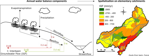
Abstract For a better understanding of the spatial variability of the hydrological response of catchments to flood events, the hydrological indicators obtained from annual water balances can be regionalized. However, many natural catchments are non-conservative, essentially due to interbasin groundwater flow (IGF) that hinders the application of water balances with traditional terms only, such as precipitation, streamflow and evapotranspiration. We thus carried out annual water balances including IGF on both conservative and non-conservative catchments of medium size (100–500 km2), subject to karst processes. To this end, we adapted the L’vovich annual water balance to account for IGF, including hydrograph separation and coupled it to a geomorphological analysis. Water balances were done at the elementary catchment scale, here either a headwater catchment, or an intermediate catchment delimited by two gauging stations. We applied this approach to 120 elementary catchments for which daily rainfall and runoff data were available. These catchments belong to 12 French drainage basins, located in partially or totally karstified regions (Cevennes, Jura, Normandy) subject to variable IGF depending on the extent of karst units. First, our results show that IGF can represent a significant part of the annual water balance, and that accounting for this component substantially improves the understanding of catchment processes. Second, several study sites showed correlations between hydrological and geomorphological parameters, providing interesting perspectives in terms of regionalization, in particular regarding ungauged basins. Our results provide a better understanding of the gains and losses affecting stormflow and baseflow components in catchments prone to important IGF.
中文翻译:

流域间地下水流:特征、岩溶区的作用、对年度水量平衡和洪水过程的影响
摘要 为了更好地了解流域对洪水事件的水文响应的空间变异性,可以对从年度水量平衡中获得的水文指标进行区域化。然而,许多自然集水区是非保守的,主要是由于流域间地下水流 (IGF) 阻碍了仅使用传统术语(例如降水、河流流量和蒸发蒸腾)来应用水平衡。因此,我们在受岩溶过程影响的中等规模(100-500 平方公里)的保守和非保守流域进行了年度水平衡,包括 IGF。为此,我们调整了 L'vovich 年度水平衡以解释 IGF,包括水位图分离并将其与地貌分析相结合。水平衡是在基本流域尺度上完成的,这里要么是源头集水区,要么是由两个测量站划定的中间集水区。我们将此方法应用于 120 个基本集水区,这些集水区的日降雨量和径流数据是可用的。这些流域属于 12 个法国流域,位于部分或完全岩溶地区(塞文山脉、侏罗山、诺曼底),根据岩溶单元的范围,IGF 会发生变化。首先,我们的结果表明 IGF 可以代表年度水平衡的重要组成部分,并且对这一组成部分的考虑大大提高了对流域过程的理解。其次,几个研究地点显示了水文和地貌参数之间的相关性,在区域化方面提供了有趣的观点,特别是关于未测量的盆地。
更新日期:2020-06-01
中文翻译:
流域间地下水流:特征、岩溶区的作用、对年度水量平衡和洪水过程的影响
摘要 为了更好地了解流域对洪水事件的水文响应的空间变异性,可以对从年度水量平衡中获得的水文指标进行区域化。然而,许多自然集水区是非保守的,主要是由于流域间地下水流 (IGF) 阻碍了仅使用传统术语(例如降水、河流流量和蒸发蒸腾)来应用水平衡。因此,我们在受岩溶过程影响的中等规模(100-500 平方公里)的保守和非保守流域进行了年度水平衡,包括 IGF。为此,我们调整了 L'vovich 年度水平衡以解释 IGF,包括水位图分离并将其与地貌分析相结合。水平衡是在基本流域尺度上完成的,这里要么是源头集水区,要么是由两个测量站划定的中间集水区。我们将此方法应用于 120 个基本集水区,这些集水区的日降雨量和径流数据是可用的。这些流域属于 12 个法国流域,位于部分或完全岩溶地区(塞文山脉、侏罗山、诺曼底),根据岩溶单元的范围,IGF 会发生变化。首先,我们的结果表明 IGF 可以代表年度水平衡的重要组成部分,并且对这一组成部分的考虑大大提高了对流域过程的理解。其次,几个研究地点显示了水文和地貌参数之间的相关性,在区域化方面提供了有趣的观点,特别是关于未测量的盆地。


 京公网安备 11010802027423号