当前位置:
X-MOL 学术
›
J. Hydrol.
›
论文详情
Our official English website, www.x-mol.net, welcomes your
feedback! (Note: you will need to create a separate account there.)
Evaluating watershed-based optimized decision support framework for conservation practice placement in Plum Creek Minnesota
Journal of Hydrology ( IF 5.9 ) Pub Date : 2020-04-01 , DOI: 10.1016/j.jhydrol.2020.124573 R. Srinivas , Matt Drewitz , Joe Magner
Journal of Hydrology ( IF 5.9 ) Pub Date : 2020-04-01 , DOI: 10.1016/j.jhydrol.2020.124573 R. Srinivas , Matt Drewitz , Joe Magner
|
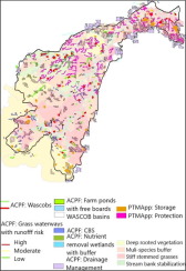
Abstract Targeting field-scale implementation of conservation practices (CPs) in agricultural watersheds is critical to meeting sustainable resource management goals. This not only needs accurate and extensive field-scale assessment, but also incorporation of willingness of the farmers to adopt the suite of practices. Many useful watershed models have not only lacked in accurate siting of field-scale practices based on rigorous physiographic/terrain criteria and hydro-conditioned digital elevation models (DEMs), but also limited in mathematically incorporating farmer’s uncertain, diverse and conflicting viewpoints into the model, which is pivotal to TMDL scenario assessment. This study develops an integrated decision support framework (DSF) to site CP opportunities at the field-scale using high-resolution Light Detection and Ranging (LiDAR)-hydro-conditioned DEM and other secondary data. Using python coding, DSF integrates three robust models namely Prioritize, Target and Measure Application (PTMApp), Agricultural Conservation Planning Framework (ACPF) and Hydrological Simulation Program FORTRAN-Scenario Application Manager (HSPF-SAM). The novel nature of this framework is its ability to facilitate precision planning at field-scale by siting the optimized conservation practices to achieve TMDL’s based on (i) rigorous terrain derivatives and siting criteria; (ii) simulation of accurate stream flow network (extensive hydro-conditioning and D infinity approach for flow accumulation); and (iii) incorporating diverse, conflicting and uncertain preferences of farmers using fuzzy logic. The framework offers a simplified interface to the locals to simultaneously address agronomical (siting practices to improve soil health and crop productivity), hydrological (improving water quality, TMDL’s), ecological (delineation of sites for riparian buffers) and socio-economic (farmer preferences and cost-analysis) objectives with moderate technical expertise. Besides field-scale practice siting, one of the superior features of the model is its flexibility to filter out even technically feasible cost-effective practices if they are not preferred by farmers, and thus giving a realistic assessment of TMDL’s. The model is applicable to any Hydrologic Unit Code (HUC-12) sub-watershed and has been demonstrated for Plum Creek watershed in Minnesota. Results showed 537 cost-effective practices including bioreactors, grassed waterways, nutrient removal wetlands, water and sediment control basins and riparian buffers yielded an 8.5% reduction in total nitrogen constrained with a budget of $250,000. Field-scale maps generated through this DSF empowers practitioners and farmers to work together to make implementation decisions based on sound agronomic, water quality, and economic considerations.
中文翻译:

评估基于流域的优化决策支持框架,用于明尼苏达州 Plum Creek 的保护实践安置
摘要 在农业流域中以田间规模实施保护措施 (CP) 是实现可持续资源管理目标的关键。这不仅需要准确和广泛的田间规模评估,还需要结合农民采用这套做法的意愿。许多有用的流域模型不仅缺乏基于严格地貌/地形标准和水力调节数字高程模型 (DEM) 的田间尺度实践的准确选址,而且在数学上将农民不确定、多样和相互矛盾的观点纳入模型方面也受到限制,这是 TMDL 情景评估的关键。本研究开发了一个综合决策支持框架 (DSF),使用高分辨率光探测和测距 (LiDAR) 水力调节 DEM 和其他辅助数据在现场范围内定位 CP 机会。使用 python 编码,DSF 集成了三个强大的模型,即优先、目标和测量应用程序 (PTMApp)、农业保护规划框架 (ACPF) 和水文模拟程序 FORTRAN-场景应用程序管理器 (HSPF-SAM)。该框架的新颖之处在于,它能够根据 (i) 严格的地形导数和选址标准,通过选址优化的保护实践来实现 TMDL,从而促进田间规模的精确规划;(ii) 模拟精确的河流流动网络(广泛的水力调节和流量累积的 D 无穷大方法);(iii) 结合多样化,使用模糊逻辑的农民的冲突和不确定的偏好。该框架为当地人提供了一个简化的界面,以同时解决农艺(改善土壤健康和作物生产力的选址实践)、水文(改善水质,TMDL)、生态(划定河岸缓冲区的地点)和社会经济(农民偏好)和成本分析)具有中等技术专长的目标。除了田间规模的实践选址,该模型的优势之一是它可以灵活地过滤掉农民不喜欢的技术上可行的成本效益实践,从而对 TMDL 进行现实评估。该模型适用于任何水文单位代码 (HUC-12) 子流域,并已在明尼苏达州的 Plum Creek 流域中得到验证。结果显示,包括生物反应器、草地水道、养分去除湿地、水和沉积物控制盆地和河岸缓冲区在内的 537 项具有成本效益的做法在预算为 250,000 美元的情况下使总氮减少了 8.5%。通过此 DSF 生成的田间比例地图使从业者和农民能够共同努力,根据合理的农艺、水质和经济考虑做出实施决策。
更新日期:2020-04-01
中文翻译:
评估基于流域的优化决策支持框架,用于明尼苏达州 Plum Creek 的保护实践安置
摘要 在农业流域中以田间规模实施保护措施 (CP) 是实现可持续资源管理目标的关键。这不仅需要准确和广泛的田间规模评估,还需要结合农民采用这套做法的意愿。许多有用的流域模型不仅缺乏基于严格地貌/地形标准和水力调节数字高程模型 (DEM) 的田间尺度实践的准确选址,而且在数学上将农民不确定、多样和相互矛盾的观点纳入模型方面也受到限制,这是 TMDL 情景评估的关键。本研究开发了一个综合决策支持框架 (DSF),使用高分辨率光探测和测距 (LiDAR) 水力调节 DEM 和其他辅助数据在现场范围内定位 CP 机会。使用 python 编码,DSF 集成了三个强大的模型,即优先、目标和测量应用程序 (PTMApp)、农业保护规划框架 (ACPF) 和水文模拟程序 FORTRAN-场景应用程序管理器 (HSPF-SAM)。该框架的新颖之处在于,它能够根据 (i) 严格的地形导数和选址标准,通过选址优化的保护实践来实现 TMDL,从而促进田间规模的精确规划;(ii) 模拟精确的河流流动网络(广泛的水力调节和流量累积的 D 无穷大方法);(iii) 结合多样化,使用模糊逻辑的农民的冲突和不确定的偏好。该框架为当地人提供了一个简化的界面,以同时解决农艺(改善土壤健康和作物生产力的选址实践)、水文(改善水质,TMDL)、生态(划定河岸缓冲区的地点)和社会经济(农民偏好)和成本分析)具有中等技术专长的目标。除了田间规模的实践选址,该模型的优势之一是它可以灵活地过滤掉农民不喜欢的技术上可行的成本效益实践,从而对 TMDL 进行现实评估。该模型适用于任何水文单位代码 (HUC-12) 子流域,并已在明尼苏达州的 Plum Creek 流域中得到验证。结果显示,包括生物反应器、草地水道、养分去除湿地、水和沉积物控制盆地和河岸缓冲区在内的 537 项具有成本效益的做法在预算为 250,000 美元的情况下使总氮减少了 8.5%。通过此 DSF 生成的田间比例地图使从业者和农民能够共同努力,根据合理的农艺、水质和经济考虑做出实施决策。


 京公网安备 11010802027423号