ISPRS Journal of Photogrammetry and Remote Sensing ( IF 10.6 ) Pub Date : 2020-01-08 , DOI: 10.1016/j.isprsjprs.2019.12.014 Miguel M. Pinto , Renata Libonati , Ricardo M. Trigo , Isabel F. Trigo , Carlos C. DaCamara
|
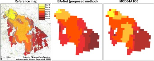
Over the past decades, methods for burned areas mapping and dating from remote sensing imagery have been the object of extensive research. The limitations of current methods, together with the heavy pre-processing of input data they require, make them difficult to improve or apply to different satellite sensors. Here, we explore a deep learning approach based on daily sequences of multi-spectral images, as a promising and flexible technique that can be applicable to observations with various spatial and spectral resolutions. We test the proposed model for five regions around the globe using input data from VIIRS 750 m bands resampled to a 0.01° spatial resolution grid. The derived burned areas are validated against higher resolution reference maps and compared with the MCD64A1 Collection 6 and FireCCI51 global burned area datasets. We show that the proposed methodology achieves competitive results in the task of burned areas mapping, despite using lower spatial resolution observations than the two global datasets. Furthermore, we improve the task of burned areas dating for the considered regions of study when compared with state-of-the-art products. We also show that our model can be used to map burned areas for low burned fraction levels and that it can operate in near-real-time, converging to the final solution in only a few days. The obtained results are a strong indication of the advantage of deep learning approaches for the problem of mapping and dating of burned areas and provide several routes for future research.
中文翻译:
使用卫星图像的时间序列对燃烧区域进行映射和约会的深度学习方法
在过去的几十年中,用于烧伤区域的地图绘制和遥感影像绘制的方法一直是广泛研究的对象。当前方法的局限性以及所需的输入数据的大量预处理使其难以改进或难以应用于不同的卫星传感器。在这里,我们探索基于每日多光谱图像序列的深度学习方法,这是一种有前途且灵活的技术,可应用于具有各种空间和光谱分辨率的观测。我们使用从VIIRS 750 m波段重新采样到0.01°空间分辨率网格的输入数据测试了全球五个区域的建议模型。派生的燃烧区域已针对更高分辨率的参考地图进行了验证,并与MCD64A1 Collection 6和FireCCI51全局燃烧区域数据集进行了比较。我们表明,尽管使用的空间分辨率观测值比两个全局数据集要低,但所提出的方法在燃烧区域映射的任务中取得了竞争性结果。此外,与最先进的产品相比,我们改善了研究区域内可燃区域的任务。我们还表明,我们的模型可用于绘制低燃烧分数水平的燃烧区域,并且它可以近实时运行,仅需几天即可收敛到最终解决方案。获得的结果有力地表明了深度学习方法在燃烧区域的制图和测年问题上的优势,并为未来的研究提供了几种途径。尽管使用的空间分辨率观测值低于两个全局数据集。此外,与最先进的产品相比,我们改善了研究区域内可燃区域的任务。我们还表明,我们的模型可用于绘制低燃烧分数水平的燃烧区域,并且它可以近实时运行,仅需几天即可收敛到最终解决方案。获得的结果有力地表明了深度学习方法在燃烧区域的制图和测年问题上的优势,并为未来的研究提供了几种途径。尽管使用的空间分辨率观测值低于两个全局数据集。此外,与最先进的产品相比,我们改善了研究区域内可燃区域的任务。我们还表明,我们的模型可用于绘制低燃烧分数水平的燃烧区域,并且它可以近实时运行,仅需几天即可收敛到最终解决方案。获得的结果有力地表明了深度学习方法在燃烧区域的制图和测年问题上的优势,并为未来的研究提供了几种途径。我们还表明,我们的模型可用于绘制低燃烧分数水平的燃烧区域,并且它可以近实时运行,仅需几天即可收敛到最终解决方案。获得的结果有力地表明了深度学习方法在燃烧区域的制图和测年问题上的优势,并为未来的研究提供了几种途径。我们还表明,我们的模型可用于绘制低燃烧分数水平的燃烧区域,并且它可以近实时运行,仅需几天即可收敛到最终解决方案。获得的结果有力地表明了深度学习方法在燃烧区域的制图和测年问题上的优势,并为未来的研究提供了几种途径。


 京公网安备 11010802027423号