Ecological Indicators ( IF 7.0 ) Pub Date : 2020-01-08 , DOI: 10.1016/j.ecolind.2019.106051 Marissa N. Karpack , Ryan R. Morrison , Ryan A. McManamay
|
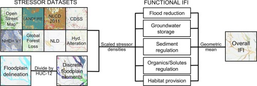
Floodplain integrity can be defined as the ability of a floodplain to support essential geomorphic, hydrologic, and ecological functions that maintain biodiversity and ecosystem services. Humans alter floodplain functionality by changing the physical landscape of the floodplain or by altering river flow regimes and subsequent floodplain inundation dynamics. This research evaluates floodplain integrity by assessing the prevalence of anthropogenic modifications to hydrology and landscape. Specifically, the objectives of this research are to: 1) develop a methodology to assess floodplain integrity using geospatial datasets available for large spatial scales; and 2) use the methodology to evaluate spatial patterns of floodplain integrity in the state of Colorado. To accomplish these objectives, we evaluated the critical floodplain functions of attenuating floods, storing groundwater, regulating sediment, providing habitat, and regulating organics and solutes. At present, this work is the first to quantify the integrity of specific floodplain functions instead of measuring floodplain health solely by ecological integrity. We applied the index of floodplain integrity methodology in the state of Colorado to analyze the integrity of each of the five floodplain functions and the aggregated overall integrity. In Colorado, overall floodplain integrity decreased as stream order increased above third order streams. Floodplain integrity was also lower in floodplains that intersected urban areas than those that did not, which indicates the index of floodplain integrity captured the adverse relationship between development and floodplain health established in literature. By quantifying anthropogenic reductions to floodplain functionality at broad spatial scales, the index of floodplain integrity can help target restoration efforts towards the most affected functions and areas.
中文翻译:
使用完整性指标对洪泛区功能进行定量评估
洪泛区完整性可以定义为洪泛区支持维持生物多样性和生态系统服务的基本地貌,水文和生态功能的能力。人类通过改变洪泛区的自然景观或通过改变河流流量状况和随后的洪泛区淹没动态来改变洪泛区功能。这项研究通过评估人为因素对水文和景观改造的普遍程度来评估洪泛区的完整性。具体而言,本研究的目的是:1)利用可用于大空间尺度的地理空间数据集,开发一种评估洪泛区完整性的方法;2)使用该方法评估科罗拉多州洪泛区完整性的空间格局。为了实现这些目标,我们评估了洪泛区在减洪,存储地下水,调节沉积物,提供栖息地以及调节有机物和溶质方面的关键功能。目前,这项工作是第一个量化特定洪泛区功能完整性的方法,而不是仅通过生态完整性来衡量洪泛区健康的方法。我们应用了科罗拉多州的洪泛区完整性方法学指数来分析五个洪泛区功能中每个功能的完整性和汇总的整体完整性。在科罗拉多州,总体洪泛平原的完整性随着河流水位增加到三流以上而下降。在与城市地区相交的洪泛区中,洪泛区的完整性也较低,这表明洪泛区完整性指数反映了文献中建立的洪泛区发展与洪泛区健康之间的不利关系。通过在宽泛的空间范围内量化洪泛区功能的人为减少量,洪泛区完整性指标可以帮助将恢复工作的目标对准受影响最大的功能和区域。


 京公网安备 11010802027423号