Ecological Indicators ( IF 7.0 ) Pub Date : 2020-01-08 , DOI: 10.1016/j.ecolind.2019.106029 Thilo Wellmann , Angela Lausch , Sebastian Scheuer , Dagmar Haase
|
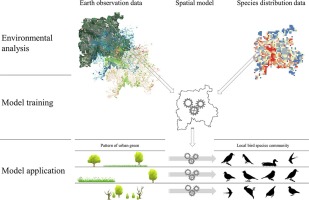
Birds respond strongly to vegetation structure and composition, yet typical species distribution models (SDMs) that incorporate Earth observation (EO) data use discrete land-use/cover data to model habitat suitability. Since this neglects factors of internal spatial composition and heterogeneity of EO data, we suggest a novel scheme deriving continuous indicators of vegetation heterogeneity from high-resolution EO data.
The deployed concepts encompass vegetation fractions for determining vegetation density and spectral traits for the quantification of vegetation heterogeneity. Both indicators are derived from RapidEye data, thus featuring a continuous spatial resolution of 6.5 m. Using these indicators as predictors, we model breeding bird habitats using a random forest (RF) classifier for the city of Leipzig, Germany using a single EO image.
SDMs are trained for the breeding sites of 44 urban bird species, featuring medium to very high accuracies (59–90%). Analysing similarities between the models regarding variable importance of single predictors allows species groups to be determined based on their preferences and dependencies regarding the amount of vegetation and its spatial and structural heterogeneity. When combining the SDMs, models of urban bird species richness can be derived.
The combination of high-resolution EO data paired with the RF machine learning technique creates very detailed insights into the ecology of the urban avifauna, opening up opportunities of optimising greenspace management schemes or urban development in densifying cities concerning overall bird species richness or single species under threat of local extinction.
中文翻译:
在城市环境中使用光谱特征概念和机器学习的基于地球观测的鸟类物种分布模型指示
鸟类对植被的结构和成分反应强烈,但是结合了地球观测(EO)数据的典型物种分布模型(SDM)使用离散的土地利用/覆盖数据来模拟栖息地的适宜性。由于这忽略了EO数据的内部空间组成和异质性的因素,因此,我们提出了一种从高分辨率EO数据中导出植被异质性连续指标的新方案。
所部署的概念包括用于确定植被密度的植被分数和用于量化植被异质性的光谱特征。这两个指标均来自RapidEye数据,因此具有6.5 m的连续空间分辨率。使用这些指标作为预测指标,我们使用单个EO图像,使用随机森林(RF)分类器对德国莱比锡市的鸟类繁殖栖息地进行建模。
对SDM进行了44种城市鸟类繁殖地点的培训,其特征为中度到极高的准确度(59–90%)。通过分析模型之间关于单个预测变量重要性的相似性,可以根据物种的偏好和对植被数量及其空间和结构异质性的依赖性来确定物种组。当结合SDM时,可以得出城市鸟类物种丰富度的模型。
高分辨率EO数据与RF机器学习技术的结合,为城市鸟类生态学提供了非常详细的见解,为优化绿色空间管理方案或城市发展提供了机会,使致密化城市的总体鸟类物种丰富度或单个物种在局部灭绝的威胁。


 京公网安备 11010802027423号