Ecological Indicators ( IF 7.0 ) Pub Date : 2020-01-09 , DOI: 10.1016/j.ecolind.2020.106066 Yu Peng , Qinghui Wang , Lan Bai
|
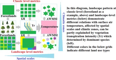
Land use changes are widely known as one of the drivers of land surface temperature variation. However, the influence of composition of various land use types and their configuration, i.e. landscape pattern, on regional temperature is still unknown. We test the hypotheses: (1) surface air temperature would vary according to landscape pattern, and (2) these effects would vary, demonstrating scale- and site-dependence effects through different vegetation transpiration rates. The relationships of 360 landscape metrics, indicating multiple dimensions of landscape pattern, and regional temperature at five climatic zones at five spatial scales in southern hilly China were examined through Pearson correlation analysis, stepwise regression and redundancy analysis. The area and number of grassland, building, and dry cropland patches are positively correlated with temperature; the area and density of forestland, shrubland, wet cropland, and water patches have cooling effects. The optimal scale and landscape metrics are also different between different climate zones. Landscape-level vegetation transpiration, determined by the dominant species, may partially explain why landscape pattern affects regional temperature. These findings provide new insights for understanding land use–temperature interactions and designing climate adaptation and mitigation strategies. Suitable landscape pattern, optimal scale, and dominant species should be considered in landscape planning and land use management to mitigate the impacts of the projected climatic warming.


 京公网安备 11010802027423号