当前位置:
X-MOL 学术
›
J. South Am. Earth Sci.
›
论文详情
Our official English website, www.x-mol.net, welcomes your feedback! (Note: you will need to create a separate account there.)
Strike-slip related folding within the Malvinas/Falkland Trough (south-western Atlantic ocean)
Journal of South American Earth Sciences ( IF 1.8 ) Pub Date : 2020-03-01 , DOI: 10.1016/j.jsames.2019.102452 Federico D. Esteban , Juan Pablo Ormazabal , Fermín Palma , Lubin Eric Cayo , Emanuele Lodolo , Alejandro Tassone
Journal of South American Earth Sciences ( IF 1.8 ) Pub Date : 2020-03-01 , DOI: 10.1016/j.jsames.2019.102452 Federico D. Esteban , Juan Pablo Ormazabal , Fermín Palma , Lubin Eric Cayo , Emanuele Lodolo , Alejandro Tassone
|
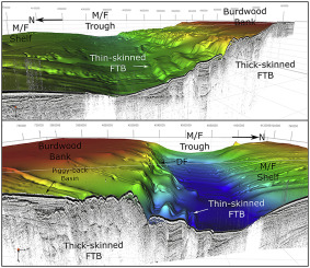
Abstract The Malvinas/Falkland Trough (M/FT) is an E-W trending bathymetric depression along which runs the present-day South American-Scotia plate boundary. To the north of the M/FT lies the southern sector of the South Malvinas/Falkland Basin, and to the south lies the Burdwood Bank, an elongated morphological high constituting part of the South Scotia Ridge. Analysis of bathymetric and slope maps, integrated with seismic reflection profiles, have allowed describing in detail the M/FT in the sector comprised between 60° and 57° W. Data show the presence of an array of folds forming a thin-skinned fold-and-thrust Belt (FTB), previously interpreted as an active compressional field. The thin-skinned FTB is developed in a triangular-shaped area, which extends ca. 100 km in the E-W direction and 16 km in the N-S direction. Four parallel, asymmetric folds that develop to progressively greater water depths (between 1600 and 2600 m depth) towards the north, with orientations ESE-WNW and lengths that vary between 22 and 98 km, have been recognized. These folds are constituted by Late Cenozoic sediments that are undeformed in the Malvinas/Falkland Trough. The development of folds, which began in the late Miocene (ca. 7 Ma), was associated with the left-lateral strike-slip tectonic regime of the Magallanes-Fagnano-Malvinas lineament, the western segment of the South American-Scotia plate boundary.
中文翻译:

马尔维纳斯/福克兰海槽(大西洋西南部)内的走滑相关褶皱
摘要 马尔维纳斯/福克兰海槽 (M/FT) 是一个 EW 趋势的测深洼地,沿着今天的南美-斯科舍板块边界延伸。M/FT 的北面是南马尔维纳斯/福克兰盆地的南段,南面是 Burdwood Bank,这是一个细长的形态高地,构成了南斯科舍海脊的一部分。对测深图和坡度图的分析,结合地震反射剖面,可以详细描述包含在 60° 和 57° W 之间的扇区中的 M/FT。数据显示存在一系列褶皱,形成薄皮褶皱。逆冲带 (FTB),以前被解释为一个活跃的压缩场。薄皮 FTB 在三角形区域中发育,延伸约 EW 方向 100 公里,NS 方向 16 公里。四个平行,已经认识到不对称褶皱向北逐渐增加水深(深度在 1600 至 2600 米之间),方向为 ESE-WNW,长度在 22 至 98 公里之间变化。这些褶皱由在马尔维纳斯/福克兰海槽中未变形的晚新生代沉积物构成。褶皱的发展始于中新世晚期(约 7 Ma),与南美-斯科舍板块边界西段 Magallanes-Fagnano-Malvinas 线性构造的左侧走滑构造体制有关. 这些褶皱由在马尔维纳斯/福克兰海槽中未变形的晚新生代沉积物构成。褶皱的发展始于中新世晚期(约 7 Ma),与南美-斯科舍板块边界西段 Magallanes-Fagnano-Malvinas 线性构造的左侧走滑构造体制有关. 这些褶皱由在马尔维纳斯/福克兰海槽中未变形的晚新生代沉积物构成。褶皱的发展始于中新世晚期(约 7 Ma),与南美-斯科舍板块边界西段 Magallanes-Fagnano-Malvinas 线性构造的左侧走滑构造体制有关.
更新日期:2020-03-01
中文翻译:
马尔维纳斯/福克兰海槽(大西洋西南部)内的走滑相关褶皱
摘要 马尔维纳斯/福克兰海槽 (M/FT) 是一个 EW 趋势的测深洼地,沿着今天的南美-斯科舍板块边界延伸。M/FT 的北面是南马尔维纳斯/福克兰盆地的南段,南面是 Burdwood Bank,这是一个细长的形态高地,构成了南斯科舍海脊的一部分。对测深图和坡度图的分析,结合地震反射剖面,可以详细描述包含在 60° 和 57° W 之间的扇区中的 M/FT。数据显示存在一系列褶皱,形成薄皮褶皱。逆冲带 (FTB),以前被解释为一个活跃的压缩场。薄皮 FTB 在三角形区域中发育,延伸约 EW 方向 100 公里,NS 方向 16 公里。四个平行,已经认识到不对称褶皱向北逐渐增加水深(深度在 1600 至 2600 米之间),方向为 ESE-WNW,长度在 22 至 98 公里之间变化。这些褶皱由在马尔维纳斯/福克兰海槽中未变形的晚新生代沉积物构成。褶皱的发展始于中新世晚期(约 7 Ma),与南美-斯科舍板块边界西段 Magallanes-Fagnano-Malvinas 线性构造的左侧走滑构造体制有关. 这些褶皱由在马尔维纳斯/福克兰海槽中未变形的晚新生代沉积物构成。褶皱的发展始于中新世晚期(约 7 Ma),与南美-斯科舍板块边界西段 Magallanes-Fagnano-Malvinas 线性构造的左侧走滑构造体制有关. 这些褶皱由在马尔维纳斯/福克兰海槽中未变形的晚新生代沉积物构成。褶皱的发展始于中新世晚期(约 7 Ma),与南美-斯科舍板块边界西段 Magallanes-Fagnano-Malvinas 线性构造的左侧走滑构造体制有关.


 京公网安备 11010802027423号