当前位置:
X-MOL 学术
›
Tectonophysics
›
论文详情
Our official English website, www.x-mol.net, welcomes your
feedback! (Note: you will need to create a separate account there.)
Deep structure of the western coast of the Makran subduction zone, SE Iran
Tectonophysics ( IF 2.7 ) Pub Date : 2020-02-01 , DOI: 10.1016/j.tecto.2019.228314 K. Motaghi , E. Shabanian , T. Nozad-Khalil
Tectonophysics ( IF 2.7 ) Pub Date : 2020-02-01 , DOI: 10.1016/j.tecto.2019.228314 K. Motaghi , E. Shabanian , T. Nozad-Khalil
|
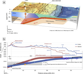
Abstract The Makran subduction zone is one of the world's least well documented active subduction zones. We investigate the geometry of subsurface velocity interfaces across the western coastal Makran by means of teleseismic data for the first time. The data were gathered by two permanent and four temporary seismic stations. We calculated P receiver functions and jointly inverted them with surface wave dispersion data to generate a 2-D shear wave velocity model. Employing this model, we migrated receiver functions to depth and show two gently northward dipping interfaces at depths of 9–15 km as the base of the accretionary wedge and 27–31 km as the Moho boundary. 360-degree periodic amplitude variation of the Ps pulse at 0.4 s and 1.4 s are modeled as an anisotropic layer between 2 and 9 km near the Makran shoreline. We interpret this layer as a signature for the accretionary prism of the subduction zone beneath the coastal Makran. One interesting observation is that all multiples of the Moho pulse have a twin. By H-κ stacking of receiver functions, we showed that the twin multiples of the Moho boundary could be a signature of a thin (~ 4.5–7 km) high velocity oceanic crust located at a depth range of 24.5 km to 31.5 km. Our new model for western Makran shows that the coastal Makran is still on the oceanic lithosphere and the filled trench is located almost 200 km north of the active accretion front. This different geometry for the subduction has implications for the location and rupture parameters of future potential megathrust events which, in the western Makran, could have significant influences on seismic hazard, tsunami propagation and thermal structure modeling of the subduction zone.
中文翻译:

伊朗东南部马克兰俯冲带西海岸深部结构
摘要 Makran 俯冲带是世界上记录最少的活动俯冲带之一。我们首次通过远震数据研究了横跨西部沿海 Makran 的地下速度界面的几何形状。数据由两个永久地震台和四个临时地震台收集。我们计算了 P 接收器函数并将它们与表面波色散数据联合反演以生成二维横波速度模型。使用这个模型,我们将接收函数迁移到深度,并在 9-15 公里的深度作为增生楔的底部和 27-31 公里的莫霍面边界显示了两个向北倾斜的界面。Ps 脉冲在 0.4 s 和 1.4 s 时的 360 度周期性振幅变化被建模为 Makran 海岸线附近 2 至 9 公里处的各向异性层。我们将此层解释为沿海马克兰下方俯冲带增生棱柱的特征。一个有趣的观察结果是,莫霍面脉冲的所有倍数都有一个孪生。通过接收器函数的 H-κ 叠加,我们表明莫霍面边界的孪生多次波可能是位于 24.5 公里至 31.5 公里深度范围内的薄(约 4.5-7 公里)高速海洋地壳的特征。我们对西马克兰的新模型表明,沿海马克兰仍位于海洋岩石圈上,填充的海沟位于活动吸积前沿以北近 200 公里处。这种不同的俯冲几何形状对未来潜在的巨型逆冲事件的位置和破裂参数有影响,在马克兰西部,这些事件可能对地震危险产生重大影响,
更新日期:2020-02-01
中文翻译:
伊朗东南部马克兰俯冲带西海岸深部结构
摘要 Makran 俯冲带是世界上记录最少的活动俯冲带之一。我们首次通过远震数据研究了横跨西部沿海 Makran 的地下速度界面的几何形状。数据由两个永久地震台和四个临时地震台收集。我们计算了 P 接收器函数并将它们与表面波色散数据联合反演以生成二维横波速度模型。使用这个模型,我们将接收函数迁移到深度,并在 9-15 公里的深度作为增生楔的底部和 27-31 公里的莫霍面边界显示了两个向北倾斜的界面。Ps 脉冲在 0.4 s 和 1.4 s 时的 360 度周期性振幅变化被建模为 Makran 海岸线附近 2 至 9 公里处的各向异性层。我们将此层解释为沿海马克兰下方俯冲带增生棱柱的特征。一个有趣的观察结果是,莫霍面脉冲的所有倍数都有一个孪生。通过接收器函数的 H-κ 叠加,我们表明莫霍面边界的孪生多次波可能是位于 24.5 公里至 31.5 公里深度范围内的薄(约 4.5-7 公里)高速海洋地壳的特征。我们对西马克兰的新模型表明,沿海马克兰仍位于海洋岩石圈上,填充的海沟位于活动吸积前沿以北近 200 公里处。这种不同的俯冲几何形状对未来潜在的巨型逆冲事件的位置和破裂参数有影响,在马克兰西部,这些事件可能对地震危险产生重大影响,


 京公网安备 11010802027423号