Environmental Modelling & Software ( IF 4.8 ) Pub Date : 2018-10-13 , DOI: 10.1016/j.envsoft.2018.10.003 Lorne Leonard , Brian Miles , Bardia Heidari , Laurence Lin , Anthony M. Castronova , Barbara Minsker , Jong Lee , Charles Scaife , Lawrence E. Band
|
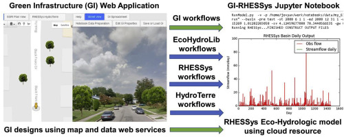
Land use planners, landscape architects, and water resource managers are using Green Infrastructure (GI) designs in urban environments to promote ecosystem services including mitigation of storm water flooding and water quality degradation. An expanded set of urban sustainability goals also includes increasing carbon sequestration, songbird habitat, reducing urban heat island effects, and improvement of landscape aesthetics. GI is conceptualized to improve water and ecosystem quality by reducing storm water runoff at the source, but when properly designed, may also benefit these expanded goals. With the increasing use of GI in urban contexts, there is an emerging need to facilitate participatory design and scenario evaluation to enable better communication between GI designers and groups impacted by these designs. Major barriers to this type of public participation is the complexity of both parameterizing, operating, visualizing and interpreting results of complex ecohydrological models at various watershed scales that are sufficient to address diverse ecosystem service goals. This paper demonstrates a set of workflows to facilitate rapid and repeatable creation of GI landscape designs which are incorporated into complex models using web applications and services. For this project, we use the RHESSys (Regional Hydro-Ecologic Simulation System) ecohydrologic model to evaluate participatory GI landscape designs generated by stakeholders and decision makers, but note that the workflow could be adapted to a set of other watershed models.
中文翻译:
在云支持的jupyter笔记本计算环境中开发参与式绿色基础设施设计,可视化和评估系统
土地使用规划人员,景观设计师和水资源管理人员正在城市环境中使用绿色基础设施(GI)设计,以促进生态系统服务,包括减轻雨水泛滥和水质退化。一组扩展的城市可持续发展目标还包括增加碳固存,鸣禽栖息地,减少城市热岛效应以及改善景观美感。地理标志的概念是通过减少源头的雨水径流来改善水和生态系统的质量,但如果设计适当,它也可能有益于这些扩展的目标。随着城市环境中地理标志的使用越来越多,迫切需要促进参与式设计和情景评估,以使地理标志设计者与受这些设计影响的群体之间实现更好的沟通。这类公众参与的主要障碍是参数化,操作,可视化和解释各种分水岭规模的复杂生态水文模型结果的复杂性,足以解决各种生态系统服务目标。本文演示了一组工作流,这些工作流有助于快速,可重复地创建GI景观设计,这些景观设计已使用Web应用程序和服务并入了复杂的模型。对于此项目,我们使用RHESSys(区域水生态模拟系统)生态水文模型来评估利益相关者和决策者生成的参与式GI景观设计,但请注意,工作流可以适应其他一组分水岭模型。在各种流域尺度上可视化和解释复杂生态水文模型的结果,足以解决各种生态系统服务目标。本文演示了一组工作流,这些工作流有助于快速,重复地创建GI景观设计,这些景观设计已使用Web应用程序和服务并入了复杂的模型。对于本项目,我们使用RHESSys(区域水文生态模拟系统)生态水文模型来评估利益相关者和决策者生成的参与性GI景观设计,但请注意,工作流程可以适应其他分水岭模型。在各种流域尺度上可视化和解释复杂生态水文模型的结果,足以解决各种生态系统服务目标。本文演示了一组工作流,这些工作流有助于快速,可重复地创建GI景观设计,这些景观设计已使用Web应用程序和服务并入了复杂的模型。对于此项目,我们使用RHESSys(区域水生态模拟系统)生态水文模型来评估利益相关者和决策者生成的参与式GI景观设计,但请注意,工作流可以适应其他一组分水岭模型。本文演示了一组工作流,这些工作流有助于快速,可重复地创建GI景观设计,这些景观设计已使用Web应用程序和服务并入了复杂的模型。对于此项目,我们使用RHESSys(区域水生态模拟系统)生态水文模型来评估利益相关者和决策者生成的参与式GI景观设计,但请注意,工作流可以适应其他一组分水岭模型。本文演示了一组工作流,这些工作流有助于快速,可重复地创建GI景观设计,这些景观设计已使用Web应用程序和服务并入了复杂的模型。对于本项目,我们使用RHESSys(区域水文生态模拟系统)生态水文模型来评估利益相关者和决策者生成的参与性GI景观设计,但请注意,工作流程可以适应其他分水岭模型。


 京公网安备 11010802027423号