当前位置:
X-MOL 学术
›
Remote Sens. Environ.
›
论文详情
Our official English website, www.x-mol.net, welcomes your
feedback! (Note: you will need to create a separate account there.)
A tree-based approach to biomass estimation from remote sensing data in a tropical agricultural landscape
Remote Sensing of Environment ( IF 11.1 ) Pub Date : 2018-12-01 , DOI: 10.1016/j.rse.2018.09.009 Sarah J. Graves , T. Trevor Caughlin , Gregory P. Asner , Stephanie A. Bohlman
Remote Sensing of Environment ( IF 11.1 ) Pub Date : 2018-12-01 , DOI: 10.1016/j.rse.2018.09.009 Sarah J. Graves , T. Trevor Caughlin , Gregory P. Asner , Stephanie A. Bohlman
|
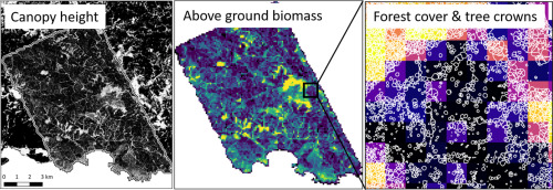
Abstract Agricultural land now exceeds forests as the dominant global biome. Because of their global dominance, and potential expansion or loss, methods to estimate biomass and carbon in agricultural areas are necessary for monitoring global terrestrial carbon stocks and predicting carbon dynamics. Agricultural areas in the tropics have substantial tree cover and associated above ground biomass (AGB) and carbon. Active remote sensing data, such as airborne LiDAR (light detection and ranging), can provide accurate estimates of biomass stocks, but common plot-based methods may not be suitable for agricultural areas with dispersed and heterogeneous tree cover. The objectives of this research are to quantify AGB of a tropical agricultural landscape using a tree-based method that directly incorporates the size of individual trees, and to understand how landscape estimates of AGB from a tree-based method compare to estimates from a plot-based method. We use high-resolution (1.12 m) airborne LiDAR data collected on a 9280-ha region of the Azuero Peninsula of Panama. We model individual tree AGB with canopy dimensions from the LiDAR data. We apply the model to individual tree crown polygons and aggregate AGB estimates to compare with previously developed plot-based estimates. We find that agricultural trees are a distinct and dominant part of our study site. The tree-based approach estimates greater AGB in pixels with low forest cover than the plot-based approach, resulting a 2-fold difference in landscape AGB estimates between the methods for non-forested areas. Additionally, one third of the total landscape AGB exists in areas having
中文翻译:

基于树的热带农业景观遥感数据生物量估算方法
摘要 农业用地现在已超过森林,成为全球主要的生物群落。由于它们在全球的主导地位以及潜在的扩张或损失,估算农业地区生物量和碳的方法对于监测全球陆地碳储量和预测碳动态是必要的。热带地区的农业区有大量的树木覆盖和相关的地上生物量 (AGB) 和碳。主动遥感数据,如机载 LiDAR(光探测和测距),可以提供生物量储量的准确估计,但常见的基于地块的方法可能不适用于树木覆盖分散和异质的农业地区。本研究的目标是使用直接结合个体树木大小的基于树的方法量化热带农业景观的 AGB,并了解基于树的方法对 AGB 的景观估计与基于图的方法的估计相比如何。我们使用在巴拿马阿苏埃罗半岛 9280 公顷地区收集的高分辨率(1.12 m)机载 LiDAR 数据。我们使用 LiDAR 数据中的树冠尺寸对单个树 AGB 进行建模。我们将该模型应用于单个树冠多边形并汇总 AGB 估计值,以与先前开发的基于图的估计值进行比较。我们发现农用树木是我们研究地点的一个独特且占主导地位的部分。基于树的方法在森林覆盖率低的像素中估计比基于地块的方法更大的 AGB,导致非森林区域的方法之间景观 AGB 估计值的 2 倍差异。此外,总景观 AGB 的三分之一存在于具有 12 m) 在巴拿马阿苏埃罗半岛 9280 公顷的地区收集的机载 LiDAR 数据。我们使用 LiDAR 数据中的树冠尺寸对单个树 AGB 进行建模。我们将该模型应用于单个树冠多边形并汇总 AGB 估计值,以与先前开发的基于图的估计值进行比较。我们发现农用树木是我们研究地点的独特和主要部分。基于树的方法在森林覆盖率低的像素中估计比基于地块的方法更大的 AGB,导致非森林区域的方法之间景观 AGB 估计值的 2 倍差异。此外,总景观 AGB 的三分之一存在于具有 12 m) 在巴拿马阿苏埃罗半岛 9280 公顷的地区收集的机载 LiDAR 数据。我们使用 LiDAR 数据中的树冠尺寸对单个树 AGB 进行建模。我们将该模型应用于单个树冠多边形并汇总 AGB 估计值,以与先前开发的基于图的估计值进行比较。我们发现农用树木是我们研究地点的独特和主要部分。基于树的方法在森林覆盖率低的像素中估计比基于地块的方法更大的 AGB,导致非森林区域的方法之间景观 AGB 估计值的 2 倍差异。此外,总景观 AGB 的三分之一存在于具有 我们将该模型应用于单个树冠多边形并汇总 AGB 估计值,以与先前开发的基于图的估计值进行比较。我们发现农用树木是我们研究地点的独特和主要部分。基于树的方法在森林覆盖率低的像素中估计比基于地块的方法更大的 AGB,导致非森林区域的方法之间景观 AGB 估计值的 2 倍差异。此外,总景观 AGB 的三分之一存在于具有 我们将该模型应用于单个树冠多边形并汇总 AGB 估计值,以与先前开发的基于图的估计值进行比较。我们发现农用树木是我们研究地点的独特和主要部分。基于树的方法在森林覆盖率低的像素中估计比基于地块的方法更大的 AGB,导致非森林区域的方法之间景观 AGB 估计值的 2 倍差异。此外,总景观 AGB 的三分之一存在于具有 导致非林区方法之间景观 AGB 估计值的 2 倍差异。此外,总景观 AGB 的三分之一存在于具有 导致非林区方法之间景观 AGB 估计值的 2 倍差异。此外,总景观 AGB 的三分之一存在于具有
更新日期:2018-12-01
中文翻译:
基于树的热带农业景观遥感数据生物量估算方法
摘要 农业用地现在已超过森林,成为全球主要的生物群落。由于它们在全球的主导地位以及潜在的扩张或损失,估算农业地区生物量和碳的方法对于监测全球陆地碳储量和预测碳动态是必要的。热带地区的农业区有大量的树木覆盖和相关的地上生物量 (AGB) 和碳。主动遥感数据,如机载 LiDAR(光探测和测距),可以提供生物量储量的准确估计,但常见的基于地块的方法可能不适用于树木覆盖分散和异质的农业地区。本研究的目标是使用直接结合个体树木大小的基于树的方法量化热带农业景观的 AGB,并了解基于树的方法对 AGB 的景观估计与基于图的方法的估计相比如何。我们使用在巴拿马阿苏埃罗半岛 9280 公顷地区收集的高分辨率(1.12 m)机载 LiDAR 数据。我们使用 LiDAR 数据中的树冠尺寸对单个树 AGB 进行建模。我们将该模型应用于单个树冠多边形并汇总 AGB 估计值,以与先前开发的基于图的估计值进行比较。我们发现农用树木是我们研究地点的一个独特且占主导地位的部分。基于树的方法在森林覆盖率低的像素中估计比基于地块的方法更大的 AGB,导致非森林区域的方法之间景观 AGB 估计值的 2 倍差异。此外,总景观 AGB 的三分之一存在于具有 12 m) 在巴拿马阿苏埃罗半岛 9280 公顷的地区收集的机载 LiDAR 数据。我们使用 LiDAR 数据中的树冠尺寸对单个树 AGB 进行建模。我们将该模型应用于单个树冠多边形并汇总 AGB 估计值,以与先前开发的基于图的估计值进行比较。我们发现农用树木是我们研究地点的独特和主要部分。基于树的方法在森林覆盖率低的像素中估计比基于地块的方法更大的 AGB,导致非森林区域的方法之间景观 AGB 估计值的 2 倍差异。此外,总景观 AGB 的三分之一存在于具有 12 m) 在巴拿马阿苏埃罗半岛 9280 公顷的地区收集的机载 LiDAR 数据。我们使用 LiDAR 数据中的树冠尺寸对单个树 AGB 进行建模。我们将该模型应用于单个树冠多边形并汇总 AGB 估计值,以与先前开发的基于图的估计值进行比较。我们发现农用树木是我们研究地点的独特和主要部分。基于树的方法在森林覆盖率低的像素中估计比基于地块的方法更大的 AGB,导致非森林区域的方法之间景观 AGB 估计值的 2 倍差异。此外,总景观 AGB 的三分之一存在于具有 我们将该模型应用于单个树冠多边形并汇总 AGB 估计值,以与先前开发的基于图的估计值进行比较。我们发现农用树木是我们研究地点的独特和主要部分。基于树的方法在森林覆盖率低的像素中估计比基于地块的方法更大的 AGB,导致非森林区域的方法之间景观 AGB 估计值的 2 倍差异。此外,总景观 AGB 的三分之一存在于具有 我们将该模型应用于单个树冠多边形并汇总 AGB 估计值,以与先前开发的基于图的估计值进行比较。我们发现农用树木是我们研究地点的独特和主要部分。基于树的方法在森林覆盖率低的像素中估计比基于地块的方法更大的 AGB,导致非森林区域的方法之间景观 AGB 估计值的 2 倍差异。此外,总景观 AGB 的三分之一存在于具有 导致非林区方法之间景观 AGB 估计值的 2 倍差异。此外,总景观 AGB 的三分之一存在于具有 导致非林区方法之间景观 AGB 估计值的 2 倍差异。此外,总景观 AGB 的三分之一存在于具有


 京公网安备 11010802027423号