当前位置:
X-MOL 学术
›
Remote Sens. Environ.
›
论文详情
Our official English website, www.x-mol.net, welcomes your
feedback! (Note: you will need to create a separate account there.)
Optimising NDWI supraglacial pond classification on Himalayan debris-covered glaciers
Remote Sensing of Environment ( IF 11.1 ) Pub Date : 2018-11-01 , DOI: 10.1016/j.rse.2018.08.020 C. Scott Watson , Owen King , Evan S. Miles , Duncan J. Quincey
Remote Sensing of Environment ( IF 11.1 ) Pub Date : 2018-11-01 , DOI: 10.1016/j.rse.2018.08.020 C. Scott Watson , Owen King , Evan S. Miles , Duncan J. Quincey

|
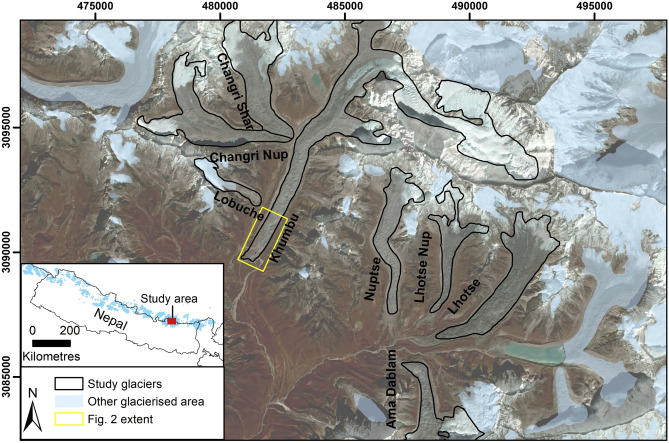
Abstract The ability of medium-resolution (10–30 m) satellite imagery to delineate the size and persistence of ponds on debris-covered glaciers is a topic of recent interest as it has become apparent through the use of fine-resolution products that smaller ponds have often been neglected. In this study, we performed a quantitative analysis of pond detection using a normalised difference water index (NDWI) applied to several widely used satellite sensors, which offer multispectral information at high radiometric precision. These data include: RapidEye (5 m spatial resolution), Sentinel-2 Multispectral Instrument (MSI) (10–20 m), and Landsat 8 Operational Land Imager (OLI) multispectral imagery (30 m). We demonstrate a method to derive an optimum NDWI value for pond classification using a subset reference dataset of 285 ponds classified using fine-resolution (0.5 m) imagery. We then applied the optimised NDWI (NDWI-O) to the remaining images to assess pond classification accuracy against a broader reference dataset of 898 ponds. NDWI values calculated using Sentinel-2 imagery showed the best spectral contrast between water and surrounding debris cover, and the strongest relationship with pixel water content (R2 = 0.56), followed by the RapidEye NDWI (R2 = 0.45). We conclude that RapidEye and Sentinel-2 imagery is best suited for accurate pond classification using a multispectral classification approach, which is important for quantifying their role in glacier ablation, meltwater regulation, and lake development. By comparison, the impact of using coarse-resolution Landsat 8 imagery to characterise surface water dynamics is minimised when applied to large glacier lakes, where the area-to-perimeter ratio is greater.
中文翻译:

优化喜马拉雅碎屑覆盖冰川的 NDWI 冰上池塘分类
摘要 中等分辨率(10-30 m)卫星图像描绘被碎片覆盖的冰川上池塘的大小和持久性的能力是最近感兴趣的一个话题,因为它通过使用较小池塘的高分辨率产品变得明显。经常被忽视。在这项研究中,我们使用归一化差值水指数 (NDWI) 对池塘检测进行了定量分析,该指数应用于几个广泛使用的卫星传感器,以高辐射精度提供多光谱信息。这些数据包括:RapidEye(5 m 空间分辨率)、Sentinel-2 多光谱仪器 (MSI) (10–20 m) 和 Landsat 8 Operational Land Imager (OLI) 多光谱图像(30 m)。我们展示了一种使用高分辨率 (0.5 m) 图像分类的 285 个池塘的子集参考数据集来推导池塘分类的最佳 NDWI 值的方法。然后,我们将优化的 NDWI (NDWI-O) 应用于剩余的图像,以根据更广泛的 898 个池塘参考数据集评估池塘分类的准确性。使用 Sentinel-2 图像计算的 NDWI 值显示水和周围碎片覆盖之间的最佳光谱对比度,以及与像素含水量的最强关系 (R2 = 0.56),其次是 RapidEye NDWI (R2 = 0.45)。我们得出结论,RapidEye 和 Sentinel-2 图像最适合使用多光谱分类方法对池塘进行准确分类,这对于量化它们在冰川消融、融水调节和湖泊发展中的作用很重要。通过对比,
更新日期:2018-11-01
中文翻译:

优化喜马拉雅碎屑覆盖冰川的 NDWI 冰上池塘分类
摘要 中等分辨率(10-30 m)卫星图像描绘被碎片覆盖的冰川上池塘的大小和持久性的能力是最近感兴趣的一个话题,因为它通过使用较小池塘的高分辨率产品变得明显。经常被忽视。在这项研究中,我们使用归一化差值水指数 (NDWI) 对池塘检测进行了定量分析,该指数应用于几个广泛使用的卫星传感器,以高辐射精度提供多光谱信息。这些数据包括:RapidEye(5 m 空间分辨率)、Sentinel-2 多光谱仪器 (MSI) (10–20 m) 和 Landsat 8 Operational Land Imager (OLI) 多光谱图像(30 m)。我们展示了一种使用高分辨率 (0.5 m) 图像分类的 285 个池塘的子集参考数据集来推导池塘分类的最佳 NDWI 值的方法。然后,我们将优化的 NDWI (NDWI-O) 应用于剩余的图像,以根据更广泛的 898 个池塘参考数据集评估池塘分类的准确性。使用 Sentinel-2 图像计算的 NDWI 值显示水和周围碎片覆盖之间的最佳光谱对比度,以及与像素含水量的最强关系 (R2 = 0.56),其次是 RapidEye NDWI (R2 = 0.45)。我们得出结论,RapidEye 和 Sentinel-2 图像最适合使用多光谱分类方法对池塘进行准确分类,这对于量化它们在冰川消融、融水调节和湖泊发展中的作用很重要。通过对比,


 京公网安备 11010802027423号