当前位置:
X-MOL 学术
›
Remote Sens. Environ.
›
论文详情
Our official English website, www.x-mol.net, welcomes your
feedback! (Note: you will need to create a separate account there.)
Parametrizing tidal creek morphology in mature saltmarshes using semi-automated extraction from lidar
Remote Sensing of Environment ( IF 11.1 ) Pub Date : 2018-05-01 , DOI: 10.1016/j.rse.2017.11.012 C. Chirol , I.D. Haigh , N. Pontee , C.E. Thompson , S.L. Gallop
Remote Sensing of Environment ( IF 11.1 ) Pub Date : 2018-05-01 , DOI: 10.1016/j.rse.2017.11.012 C. Chirol , I.D. Haigh , N. Pontee , C.E. Thompson , S.L. Gallop
|
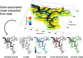
Coastal saltmarshes provide a range of ecosystem services, such as flood protection and carbon sequestration, but face rapid global losses. Managed realignment (MR) is an increasingly popular method to artificially recreate these habitats by reinstating tidal regimes to reclaimed land. However, to improve MR design, better knowledge of the processes that control morphological evolution in natural saltmarshes is needed. In this paper, we develop tools to assist in the monitoring of creek network evolution towards dynamic morphological equilibrium, a state of landform stability under current physical forcings. Using lidar (Light Detection and Ranging) datasets, we combined a semi-automated creek extraction algorithm, based on elevation and slope thresholds, with a novel algorithm for morphometric creek analysis. A comprehensive suite of morphological creek characteristics was extracted for 13 natural British saltmarshes, including: amplitude, length, sinuosity ratio, junction angle, width, depth, cross-sectional area, creek order, bifurcation ratio, drainage density, and drainage efficiency. Results closely matched with field-validated manual digitization results, and were significantly faster and less subjective to produce. Morphological equilibrium relationships from the literature were found to be applicable to the new dataset, despite yielding high prediction errors due to the inherent variety of creek network shapes in saltmarshes. New equilibrium relationships were also defined relating the creek network drainage efficiency to the mouth cross-sectional area and the marsh elevation. To improve future scheme designs, these tools will be used in further studies to monitor rates of evolution towards equilibrium in MR sites depending on their initial conditions.
中文翻译:

使用激光雷达的半自动提取技术参数化成熟盐沼中的潮汐小溪形态
沿海盐沼提供了一系列生态系统服务,例如防洪和固碳,但面临迅速的全球损失。管理调整 (MR) 是一种越来越流行的方法,通过在开垦土地上恢复潮汐制度来人为地重建这些栖息地。然而,为了改进 MR 设计,需要更好地了解控制天然盐沼中形态演化的过程。在本文中,我们开发了一些工具来协助监测小溪网络向动态形态平衡的演变,这是一种在当前物理强迫下的地貌稳定性状态。使用激光雷达(光检测和测距)数据集,我们将基于高程和坡度阈值的半自动小溪提取算法与用于形态测量小溪分析的新算法相结合。为 13 个天然英国盐沼提取了一套综合的河流形态特征,包括:幅度、长度、曲率比、交汇角、宽度、深度、横截面积、河流顺序、分叉比、排水密度和排水效率。结果与现场验证的手动数字化结果密切匹配,并且生产速度明显更快且主观性更低。发现文献中的形态平衡关系适用于新数据集,尽管由于盐沼中小溪网络形状的固有多样性而产生很高的预测误差。还定义了新的平衡关系,将小溪网络排水效率与河口横截面积和沼泽高程联系起来。为了改进未来的方案设计,
更新日期:2018-05-01
中文翻译:
使用激光雷达的半自动提取技术参数化成熟盐沼中的潮汐小溪形态
沿海盐沼提供了一系列生态系统服务,例如防洪和固碳,但面临迅速的全球损失。管理调整 (MR) 是一种越来越流行的方法,通过在开垦土地上恢复潮汐制度来人为地重建这些栖息地。然而,为了改进 MR 设计,需要更好地了解控制天然盐沼中形态演化的过程。在本文中,我们开发了一些工具来协助监测小溪网络向动态形态平衡的演变,这是一种在当前物理强迫下的地貌稳定性状态。使用激光雷达(光检测和测距)数据集,我们将基于高程和坡度阈值的半自动小溪提取算法与用于形态测量小溪分析的新算法相结合。为 13 个天然英国盐沼提取了一套综合的河流形态特征,包括:幅度、长度、曲率比、交汇角、宽度、深度、横截面积、河流顺序、分叉比、排水密度和排水效率。结果与现场验证的手动数字化结果密切匹配,并且生产速度明显更快且主观性更低。发现文献中的形态平衡关系适用于新数据集,尽管由于盐沼中小溪网络形状的固有多样性而产生很高的预测误差。还定义了新的平衡关系,将小溪网络排水效率与河口横截面积和沼泽高程联系起来。为了改进未来的方案设计,


 京公网安备 11010802027423号