Our official English website, www.x-mol.net, welcomes your
feedback! (Note: you will need to create a separate account there.)
Timing of oceans on Mars from shoreline deformation
Nature ( IF 50.5 ) Pub Date : 2018-03-01 , DOI: 10.1038/nature26144 Robert I. Citron , Michael Manga , Douglas J. Hemingway
Nature ( IF 50.5 ) Pub Date : 2018-03-01 , DOI: 10.1038/nature26144 Robert I. Citron , Michael Manga , Douglas J. Hemingway
|
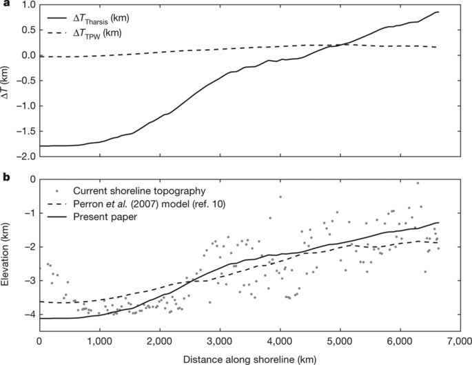
Widespread evidence points to the existence of an ancient Martian ocean. Most compelling are the putative ancient shorelines in the northern plains. However, these shorelines fail to follow an equipotential surface, and this has been used to challenge the notion that they formed via an early ocean and hence to question the existence of such an ocean. The shorelines’ deviation from a constant elevation can be explained by true polar wander occurring after the formation of Tharsis, a volcanic province that dominates the gravity and topography of Mars. However, surface loading from the oceans can drive polar wander only if Tharsis formed far from the equator, and most evidence indicates that Tharsis formed near the equator, meaning that there is no current explanation for the shorelines’ deviation from an equipotential that is consistent with our geophysical understanding of Mars. Here we show that variations in shoreline topography can be explained by deformation caused by the emplacement of Tharsis. We find that the shorelines must have formed before and during the emplacement of Tharsis, instead of afterwards, as previously assumed. Our results imply that oceans on Mars formed early, concurrent with the valley networks, and point to a close relationship between the evolution of oceans on Mars and the initiation and decline of Tharsis volcanism, with broad implications for the geology, hydrological cycle and climate of early Mars.
中文翻译:

火星上海洋从海岸线变形的时间
广泛的证据表明存在古老的火星海洋。最引人注目的是北部平原假定的古老海岸线。然而,这些海岸线没有遵循等势面,这被用来挑战它们是通过早期海洋形成的概念,从而质疑这样一个海洋的存在。海岸线与恒定高度的偏差可以通过在塔尔西斯形成后发生的真正极地漂移来解释,塔尔西斯是一个主导火星重力和地形的火山区。然而,只有在远离赤道的塔尔西斯形成时,来自海洋的表面载荷才能驱动极地漂移,而且大多数证据表明塔尔西斯形成于赤道附近,这意味着对于海岸线偏离与我们对火星的地球物理理解一致的等势线,目前没有任何解释。在这里,我们表明海岸线地形的变化可以用塔尔西斯就位引起的变形来解释。我们发现海岸线一定是在 Tharsis 就位之前和期间形成的,而不是之前假设的那样。我们的研究结果表明,火星上的海洋形成较早,与山谷网络同时发生,并指出火星上海洋的演化与塔尔西斯火山活动的开始和衰退之间存在密切关系,对火星的地质、水文循环和气候具有广泛的影响。早期的火星。在这里,我们表明,海岸线地形的变化可以用塔尔西斯就位引起的变形来解释。我们发现海岸线一定是在 Tharsis 就位之前和期间形成的,而不是之前假设的那样。我们的研究结果表明,火星上的海洋形成较早,与山谷网络同时发生,并指出火星上海洋的演化与塔尔西斯火山活动的开始和衰退之间存在密切关系,对火星的地质、水文循环和气候具有广泛的影响。早期的火星。在这里,我们表明,海岸线地形的变化可以用塔尔西斯就位引起的变形来解释。我们发现海岸线一定是在 Tharsis 就位之前和期间形成的,而不是之前假设的那样。我们的研究结果表明,火星上的海洋形成较早,与山谷网络同时发生,并指出火星上海洋的演化与塔尔西斯火山活动的开始和衰退之间存在密切关系,对火星的地质、水文循环和气候具有广泛的影响。早期的火星。
更新日期:2018-03-01
中文翻译:
火星上海洋从海岸线变形的时间
广泛的证据表明存在古老的火星海洋。最引人注目的是北部平原假定的古老海岸线。然而,这些海岸线没有遵循等势面,这被用来挑战它们是通过早期海洋形成的概念,从而质疑这样一个海洋的存在。海岸线与恒定高度的偏差可以通过在塔尔西斯形成后发生的真正极地漂移来解释,塔尔西斯是一个主导火星重力和地形的火山区。然而,只有在远离赤道的塔尔西斯形成时,来自海洋的表面载荷才能驱动极地漂移,而且大多数证据表明塔尔西斯形成于赤道附近,这意味着对于海岸线偏离与我们对火星的地球物理理解一致的等势线,目前没有任何解释。在这里,我们表明海岸线地形的变化可以用塔尔西斯就位引起的变形来解释。我们发现海岸线一定是在 Tharsis 就位之前和期间形成的,而不是之前假设的那样。我们的研究结果表明,火星上的海洋形成较早,与山谷网络同时发生,并指出火星上海洋的演化与塔尔西斯火山活动的开始和衰退之间存在密切关系,对火星的地质、水文循环和气候具有广泛的影响。早期的火星。在这里,我们表明,海岸线地形的变化可以用塔尔西斯就位引起的变形来解释。我们发现海岸线一定是在 Tharsis 就位之前和期间形成的,而不是之前假设的那样。我们的研究结果表明,火星上的海洋形成较早,与山谷网络同时发生,并指出火星上海洋的演化与塔尔西斯火山活动的开始和衰退之间存在密切关系,对火星的地质、水文循环和气候具有广泛的影响。早期的火星。在这里,我们表明,海岸线地形的变化可以用塔尔西斯就位引起的变形来解释。我们发现海岸线一定是在 Tharsis 就位之前和期间形成的,而不是之前假设的那样。我们的研究结果表明,火星上的海洋形成较早,与山谷网络同时发生,并指出火星上海洋的演化与塔尔西斯火山活动的开始和衰退之间存在密切关系,对火星的地质、水文循环和气候具有广泛的影响。早期的火星。


 京公网安备 11010802027423号