Environmental Modelling & Software ( IF 4.8 ) Pub Date : 2018-01-10 , DOI: 10.1016/j.envsoft.2017.11.036 Lorne Leonard
|
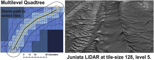
Generating quality meshes for hydrological modeling is challenging. This article demonstrates using mesh workflows to incorporate national stream networks into very large dynamic meshes for distributed High Performance Computing (HPC). A multilevel quadtree is used to partition watersheds and merge stream networks ranging from hill-slope to four level-4 Hydrological Unit Code (HUC) scales, generating mesh sizes from hundreds to tens of millions of triangles. By using a mesh workflow, it is demonstrated how users control mesh quality, including triangle sizes, and the removal of small triangles and slivers. Four watersheds are studied, ranging in scale from Shale Hills (hill-slope) to the Chesapeake Bay (177,968 sq. km.) and are used to compare mesh characteristics with user parameters and different elevation sources to generate a spectrum of multilevel quadtree meshes. By using triangles to represent land surface and stream networks, stream curvature is lost and the mesh workflow is used to demonstrate what parameters are important to maintain stream characteristics. To meet HPC constraints, the multilevel quadtree is demonstrated by picking quadtree tiles along a storm path to show how users can combine quadtree tiles at multiple levels to concentrate HPC resources for hydrological science research.
中文翻译:
面向CONUS尺度分水岭的多级网格工作流程:三角形应小到多少以捕获水文模型的水流曲率?
生成用于水文建模的高质量网格具有挑战性。本文演示了如何使用网格工作流将国家流网络合并到超大型动态网格中,以进行分布式高性能计算(HPC)。多级四叉树用于划分流域,并合并从山坡到四个四级水文单位代码(HUC)比例尺的河流网络,生成的网格尺寸范围从数百个到数千万个三角形。通过使用网格工作流程,向用户演示了用户如何控制网格质量,包括三角形大小以及去除小三角形和细条。研究了四个分水岭,规模从页岩山(山坡)到切萨皮克湾(177,968平方公里)不等。),用于将网格特征与用户参数和不同的高程源进行比较,以生成多级四叉树网格的频谱。通过使用三角形来表示陆地表面和河流网络,河流曲率会丢失,并且网格工作流可用于演示哪些参数对于维持河流特征非常重要。为了满足HPC约束,通过沿风暴路径拾取四叉树图块来演示多级四叉树,以展示用户如何在多个级别上组合四叉树图块以集中HPC资源用于水文科学研究。


 京公网安备 11010802027423号