当前位置:
X-MOL 学术
›
Remote Sens. Environ.
›
论文详情
Our official English website, www.x-mol.net, welcomes your
feedback! (Note: you will need to create a separate account there.)
Multi-temporal high-resolution imaging spectroscopy with hyperspectral 2D imagers – From theory to application
Remote Sensing of Environment ( IF 11.1 ) Pub Date : 2018-02-01 , DOI: 10.1016/j.rse.2017.10.043 Helge Aasen , Andreas Bolten
Remote Sensing of Environment ( IF 11.1 ) Pub Date : 2018-02-01 , DOI: 10.1016/j.rse.2017.10.043 Helge Aasen , Andreas Bolten
|
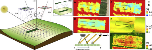
Abstract With the increasing availability of spectral sensors and consumer-grade data processing software, a democratization of imaging spectroscopy is taking place. In particular, novel lightweight 2D spectral imagers in combination with UAVs are increasingly being adapted for imaging spectroscopy. In contrast to traditional line-scanners, these sensors capture spectral information as a 2D image within every exposure. With computer vision algorithms embedded in consumer grade software packages, these data can be processed to hyperspectral digital surface models that hold spectral and 3D spatial information in very high resolution. To understand the spectral signal, however, one must comprehend the complexity of the capturing and data processing process in imaging spectroscopy with 2D imagers. This study establishes the theoretical background to comprehend the properties of spectral data acquired with 2D imagers and investigates how different data processing schemes influence the data. To improve the interpretability of a spectral signal derived for an area of interest (AOI), the specific field of view is introduced as a concept to understand the composition of pixels and their angular properties used to characterize a specific AOI within a remote sensing scene. These considerations are applied to a multi-temporal field study carried out under different illumination conditions in a barley field phenotyping experiment. It is shown that data processing significantly affects the angular properties of the spectral data and influences the apparent spectral signature. The largest differences are found in the red domain, where the signal differs by approximately 10% relative to a single nadir image. Even larger differences of approximately 14% are found in comparison with ground-based non-imaging field spectrometer measurements. The differences are explained by investigating the interaction between the angular properties of the data and canopy anisotropy, which are wavelength and growth stage dependent. Additionally, it is shown that common vegetation indices cannot normalize the differences and that the retrieval of chlorophyll is affected. In conclusion, this study helps to understand the process of imaging spectroscopy with 2D imagers and provides recommendations for future missions.
中文翻译:

使用高光谱二维成像器的多时相高分辨率成像光谱——从理论到应用
摘要 随着光谱传感器和消费级数据处理软件的日益普及,成像光谱的大众化正在发生。特别是,与无人机相结合的新型轻型 2D 光谱成像仪越来越多地适用于成像光谱。与传统的线扫描仪相比,这些传感器在每次曝光时捕获光谱信息作为 2D 图像。借助嵌入在消费级软件包中的计算机视觉算法,可以将这些数据处理为高光谱数字表面模型,以非常高分辨率保存光谱和 3D 空间信息。然而,要了解光谱信号,必须了解使用 2D 成像器成像光谱中捕获和数据处理过程的复杂性。本研究为理解二维成像仪采集的光谱数据的特性奠定了理论背景,并研究了不同的数据处理方案如何影响数据。为了提高为感兴趣区域 (AOI) 导出的光谱信号的可解释性,引入了特定视场作为一个概念,以了解用于表征遥感场景中特定 AOI 的像素组成及其角度特性。这些考虑适用于在大麦田表型实验中在不同光照条件下进行的多时相田野研究。结果表明,数据处理显着影响光谱数据的角度特性并影响表观光谱特征。在红色域中发现了最大的差异,其中信号相对于单个最低点图像相差约 10%。与基于地面的非成像场光谱仪测量结果相比,甚至发现了大约 14% 的更大差异。通过研究数据的角度特性和冠层各向异性之间的相互作用来解释这些差异,这些特性取决于波长和生长阶段。此外,结果表明,常见的植被指数无法使差异标准化,并且叶绿素的恢复受到影响。总之,这项研究有助于了解使用 2D 成像仪进行光谱成像的过程,并为未来的任务提供建议。与基于地面的非成像场光谱仪测量结果相比,甚至发现了大约 14% 的更大差异。通过研究数据的角度特性和冠层各向异性之间的相互作用来解释这些差异,这些特性取决于波长和生长阶段。此外,结果表明,常见的植被指数无法使差异标准化,并且叶绿素的恢复受到影响。总之,这项研究有助于了解使用 2D 成像仪进行光谱成像的过程,并为未来的任务提供建议。与基于地面的非成像场光谱仪测量结果相比,甚至发现了大约 14% 的更大差异。通过研究数据的角度特性和冠层各向异性之间的相互作用来解释这些差异,这些特性取决于波长和生长阶段。此外,结果表明,常见的植被指数无法使差异标准化,并且叶绿素的恢复受到影响。总之,这项研究有助于了解使用 2D 成像仪进行光谱成像的过程,并为未来的任务提供建议。结果表明,常见的植被指数不能使差异正常化,叶绿素的恢复受到影响。总之,这项研究有助于了解使用 2D 成像仪进行光谱成像的过程,并为未来的任务提供建议。结果表明,常见的植被指数不能使差异正常化,叶绿素的恢复受到影响。总之,这项研究有助于了解使用 2D 成像仪进行光谱成像的过程,并为未来的任务提供建议。
更新日期:2018-02-01
中文翻译:
使用高光谱二维成像器的多时相高分辨率成像光谱——从理论到应用
摘要 随着光谱传感器和消费级数据处理软件的日益普及,成像光谱的大众化正在发生。特别是,与无人机相结合的新型轻型 2D 光谱成像仪越来越多地适用于成像光谱。与传统的线扫描仪相比,这些传感器在每次曝光时捕获光谱信息作为 2D 图像。借助嵌入在消费级软件包中的计算机视觉算法,可以将这些数据处理为高光谱数字表面模型,以非常高分辨率保存光谱和 3D 空间信息。然而,要了解光谱信号,必须了解使用 2D 成像器成像光谱中捕获和数据处理过程的复杂性。本研究为理解二维成像仪采集的光谱数据的特性奠定了理论背景,并研究了不同的数据处理方案如何影响数据。为了提高为感兴趣区域 (AOI) 导出的光谱信号的可解释性,引入了特定视场作为一个概念,以了解用于表征遥感场景中特定 AOI 的像素组成及其角度特性。这些考虑适用于在大麦田表型实验中在不同光照条件下进行的多时相田野研究。结果表明,数据处理显着影响光谱数据的角度特性并影响表观光谱特征。在红色域中发现了最大的差异,其中信号相对于单个最低点图像相差约 10%。与基于地面的非成像场光谱仪测量结果相比,甚至发现了大约 14% 的更大差异。通过研究数据的角度特性和冠层各向异性之间的相互作用来解释这些差异,这些特性取决于波长和生长阶段。此外,结果表明,常见的植被指数无法使差异标准化,并且叶绿素的恢复受到影响。总之,这项研究有助于了解使用 2D 成像仪进行光谱成像的过程,并为未来的任务提供建议。与基于地面的非成像场光谱仪测量结果相比,甚至发现了大约 14% 的更大差异。通过研究数据的角度特性和冠层各向异性之间的相互作用来解释这些差异,这些特性取决于波长和生长阶段。此外,结果表明,常见的植被指数无法使差异标准化,并且叶绿素的恢复受到影响。总之,这项研究有助于了解使用 2D 成像仪进行光谱成像的过程,并为未来的任务提供建议。与基于地面的非成像场光谱仪测量结果相比,甚至发现了大约 14% 的更大差异。通过研究数据的角度特性和冠层各向异性之间的相互作用来解释这些差异,这些特性取决于波长和生长阶段。此外,结果表明,常见的植被指数无法使差异标准化,并且叶绿素的恢复受到影响。总之,这项研究有助于了解使用 2D 成像仪进行光谱成像的过程,并为未来的任务提供建议。结果表明,常见的植被指数不能使差异正常化,叶绿素的恢复受到影响。总之,这项研究有助于了解使用 2D 成像仪进行光谱成像的过程,并为未来的任务提供建议。结果表明,常见的植被指数不能使差异正常化,叶绿素的恢复受到影响。总之,这项研究有助于了解使用 2D 成像仪进行光谱成像的过程,并为未来的任务提供建议。


 京公网安备 11010802027423号