当前位置:
X-MOL 学术
›
Environ. Impact Assess. Rev.
›
论文详情
Our official English website, www.x-mol.net, welcomes your feedback! (Note: you will need to create a separate account there.)
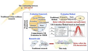
Dynamic evolution of urban resilience and its coupling mechanism with EF3D-driven natural capital utilization: Case study in three typical urban agglomerations of China
Environmental Impact Assessment Review ( IF 6.122 ) Pub Date : 2024-04-24 , DOI: 10.1016/j.eiar.2024.107518 Jing Li , He Peng , Yizhong Chen , Sisi Zhang , Pengming He , Lingzhi Yang , Minhui Si , Yiyang Yang
Environmental Impact Assessment Review ( IF 6.122 ) Pub Date : 2024-04-24 , DOI: 10.1016/j.eiar.2024.107518 Jing Li , He Peng , Yizhong Chen , Sisi Zhang , Pengming He , Lingzhi Yang , Minhui Si , Yiyang Yang
|
Improving urban resilience (UR) and natural capital utilization are critical for supporting regional sustainable development. However, most of the previous studies have separately assessed them, and their coupling mechanism is still unclear. This study develops a cloud model-based urban resilience (UR) assessment framework to explore the dynamic evolution of UR in the three typical urban agglomerations of the Yangtze River Economic Belt (YREB). Natural capital utilization is analyzed by an improved ecological footprint (EF) model. Coupling Coordination Degree (CCD) and Environmental Kuznets Theory (EKC) are integrated for revealing the relationship between UR and natural capital utilization. Results show that UR in the YREB shows an increasing trend with an average annual rate of 1.33%, and there is a significant difference in the sub-dimensions of UR. Water system resilience generally has a positive impact on UR in the early periods, but its impact later becomes negative, with over 45% of all cities' UR being negatively affected by water system resilience. The spatial distribution of EF shows a decentralized trend in the YREB. The consumption of resource stocks represented by ecological footprint depth increases during the period from 2000 to 2015, with increase rates of 1.09%, 4.73%, and 3.42% for the upstream, midstream, and downstream urban agglomerations, respectively. The CCD between UR and natural capital utilization increases from an intermediate coordination stage to a well-coordinated stage. The EKC analysis discloses that UR and natural capital utilization present inverted U-shaped curves in three urban agglomerations with spatial differences. The inflection point of UR in the upstream is earlier (in 2008) than that in the midstream (in 2014) and downstream (in 2015) urban agglomerations. Findings can help quantify the development space for each city to enter into coordinated development in the future.
更新日期:2024-04-24


 京公网安备 11010802027423号