Scientific Data ( IF 9.8 ) Pub Date : 2024-04-10 , DOI: 10.1038/s41597-024-03199-y Łukasz Janowski , Dimitrios Skarlatos , Panagiotis Agrafiotis , Paweł Tysiąc , Andrzej Pydyn , Mateusz Popek , Anna M. Kotarba-Morley , Gottfried Mandlburger , Łukasz Gajewski , Mateusz Kołakowski , Alexandra Papadaki , Juliusz Gajewski
|
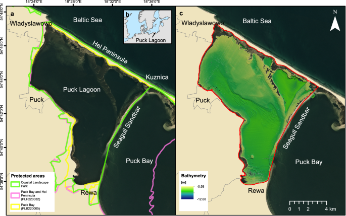
The very shallow marine basin of Puck Lagoon in the southern Baltic Sea, on the Northern coast of Poland, hosts valuable benthic habitats and cultural heritage sites. These include, among others, protected Zostera marina meadows, one of the Baltic’s major medieval harbours, a ship graveyard, and likely other submerged features that are yet to be discovered. Prior to this project, no comprehensive high-resolution remote sensing data were available for this area. This article describes the first Digital Elevation Models (DEMs) derived from a combination of airborne bathymetric LiDAR, multibeam echosounder, airborne photogrammetry and satellite imagery. These datasets also include multibeam echosounder backscatter and LiDAR intensity, allowing determination of the character and properties of the seafloor. Combined, these datasets are a vital resource for assessing and understanding seafloor morphology, benthic habitats, cultural heritage, and submerged landscapes. Given the significance of Puck Lagoon’s hydrographical, ecological, geological, and archaeological environs, the high-resolution bathymetry, acquired by our project, can provide the foundation for sustainable management and informed decision-making for this area of interest.
中文翻译:
Puck Lagoon 高分辨率光学和声学遥感数据集
波罗的海南部、波兰北部海岸的帕克泻湖非常浅的海洋盆地,拥有宝贵的底栖栖息地和文化遗产。其中包括受保护的大叶藻码头草甸、波罗的海主要的中世纪港口之一、船舶墓地以及其他可能尚未发现的水下特征。在该项目之前,该地区没有全面的高分辨率遥感数据。本文介绍了第一个数字高程模型 (DEM),该模型源自机载测深激光雷达、多波束回声测深仪、机载摄影测量和卫星图像。这些数据集还包括多波束回声测深仪反向散射和激光雷达强度,可以确定海底的特征和特性。总之,这些数据集是评估和了解海底形态、海底栖息地、文化遗产和水下景观的重要资源。鉴于帕克泻湖的水文、生态、地质和考古环境的重要性,我们的项目获得的高分辨率测深数据可以为该感兴趣区域的可持续管理和明智决策提供基础。


 京公网安备 11010802027423号