Scientific Data ( IF 9.8 ) Pub Date : 2024-04-08 , DOI: 10.1038/s41597-024-03141-2 Andrina Gincheva , Juli G. Pausas , Andrew Edwards , Antonello Provenzale , Artemi Cerdà , Chelene Hanes , Dominic Royé , Emilio Chuvieco , Florent Mouillot , Gabriele Vissio , Jesús Rodrigo , Joaquin Bedía , John T. Abatzoglou , José María Senciales González , Karen C. Short , Mara Baudena , Maria Carmen Llasat , Marta Magnani , Matthias M. Boer , Mauro E. González , Miguel Ángel Torres-Vázquez , Paolo Fiorucci , Peter Jacklyn , Renata Libonati , Ricardo M. Trigo , Sixto Herrera , Sonia Jerez , Xianli Wang , Marco Turco
|
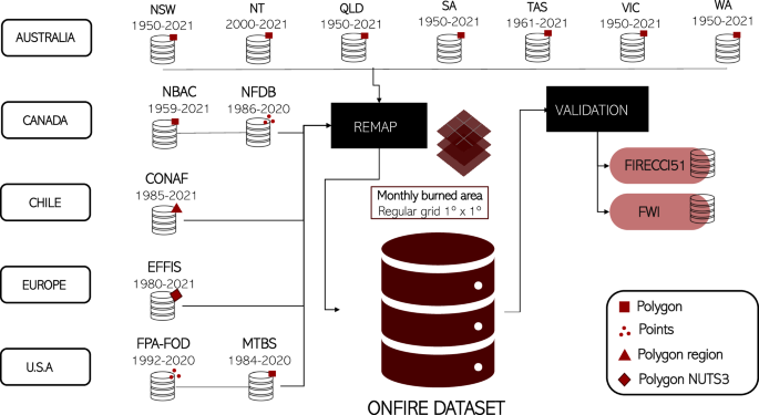
We assembled the first gridded burned area (BA) database of national wildfire data (ONFIRE), a comprehensive and integrated resource for researchers, non-government organisations, and government agencies analysing wildfires in various regions of the Earth. We extracted and harmonised records from different regions and sources using open and reproducible methods, providing data in a common framework for the whole period available (starting from 1950 in Australia, 1959 in Canada, 1985 in Chile, 1980 in Europe, and 1984 in the United States) up to 2021 on a common 1° × 1° grid. The data originate from national agencies (often, ground mapping), thus representing the best local expert knowledge. Key opportunities and limits in using this dataset are discussed as well as possible future expansions of this open-source approach that should be explored. This dataset complements existing gridded BA data based on remote sensing and offers a valuable opportunity to better understand and assess fire regime changes, and their drivers, in these regions. The ONFIRE database can be freely accessed at https://zenodo.org/record/8289245.
中文翻译:
全国荒地火灾数据月度网格化过火面积数据库
我们组建了第一个国家野火数据网格化燃烧区域 (BA) 数据库 (ONFIRE),这是一个供研究人员、非政府组织和政府机构分析地球各个地区野火的综合性综合资源。我们使用开放和可重复的方法提取和协调来自不同地区和来源的记录,在一个通用框架中提供整个可用时期的数据(从澳大利亚 1950 年开始,加拿大 1959 年开始,智利 1985 年开始,欧洲 1980 年开始,欧洲 1984 年开始)。美国)到 2021 年,采用通用 1° × 1° 网格。这些数据来自国家机构(通常是地面测绘),因此代表了当地最好的专家知识。讨论了使用该数据集的主要机会和限制,以及应该探索的这种开源方法未来可能的扩展。该数据集补充了基于遥感的现有网格 BA 数据,并为更好地了解和评估这些地区的火情变化及其驱动因素提供了宝贵的机会。 ONFIRE 数据库可以通过 https://zenodo.org/record/8289245 免费访问。


 京公网安备 11010802027423号