Our official English website, www.x-mol.net, welcomes your
feedback! (Note: you will need to create a separate account there.)
Geospatial modeling and mapping of soil erosion in India
Catena ( IF 5.4 ) Pub Date : 2024-03-25 , DOI: 10.1016/j.catena.2024.107996 Ravi Raj , Manabendra Saharia , Sumedha Chakma
Catena ( IF 5.4 ) Pub Date : 2024-03-25 , DOI: 10.1016/j.catena.2024.107996 Ravi Raj , Manabendra Saharia , Sumedha Chakma
|
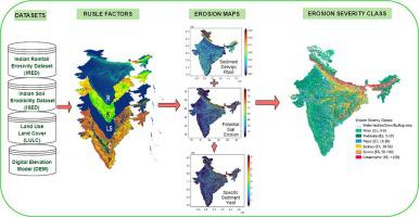
Soil erosion generally removes the topmost fertile layer of soil, affecting agricultural productivity on a larger scale. As a significant portion of the Indian economy depends on agricultural productivity, granular assessment of the impact of soil erosion becomes critical. However, a national-scale assessment of soil erosion and an impact classification system currently doesn’t exist over India. Given the resource-intensive and time-consuming nature of field experiments required for the measurement of soil loss across a vast country, the Revised Universal Soil Loss Equation (RUSLE) was extensively utilized for soil erosion calculations due to its simplicity, streamlined data requirements, and accuracy. This study estimates the yearly potential soil loss throughout India at a spatial resolution of 250 m and quantifies its variability considering districts, soil texture, soil type, land use and land cover, and basins. The relative importance of individual and combined impact of multiple parameters on quantified soil loss has been assessed using a random forest model. Rainfall erosivity (R-factor) emerges as the most crucial feature in estimating soil erosion in Indian conditions while rainfall intensity, combined with the topographic factor, demonstrated the highest influence on soil erosion in Indian conditions when the combined impact was assessed. Further, we mapped the Sediment Delivery Ratio (SDR) and Specific Sediment Yield (SSY) to assess the actual soil loss reaching downstream of basins across the national boundary. The national mean values for Sediment Delivery Ratio (SDR) and Sediment Yield (SSY) stand at 0.11 and 2.61 tons per hectare per year, respectively. The yearly potential soil loss for India is calculated at 21 tons per hectare per year, and nine out of the twenty districts with the highest susceptibility to soil erosion are in the state of Assam. Finally, a novel impact-based erosion-severity classification system has been introduced which finds that 29.46% of the landmass is prone to minor erosion while 3.17% experiences catastrophic erosion. This is the first comprehensive national-scale assessment of both soil erosion and sediment yield mapping over India, and the consequent classification system will enable the planning and implementation of soil conservation strategies locally as well as nationally.
中文翻译:

印度土壤侵蚀的地理空间建模和绘图
土壤侵蚀通常会去除最表层的肥沃土壤层,从而在更大范围内影响农业生产力。由于印度经济的很大一部分依赖于农业生产力,因此对土壤侵蚀影响的精细评估变得至关重要。然而,印度目前尚不存在全国范围的土壤侵蚀评估和影响分类系统。鉴于测量幅员辽阔的国家的土壤流失所需的现场实验资源密集且耗时,修订后的通用土壤流失方程(RUSLE)因其简单、精简的数据要求而被广泛用于土壤侵蚀计算,和准确性。本研究以 250 m 的空间分辨率估计了印度每年的潜在土壤流失,并考虑了地区、土壤质地、土壤类型、土地利用和土地覆盖以及盆地,量化了其变异性。使用随机森林模型评估了多个参数对量化土壤流失的单独影响和综合影响的相对重要性。降雨侵蚀力(R 因子)是估算印度土壤侵蚀的最关键特征,而在评估综合影响时,降雨强度与地形因素相结合,对印度土壤侵蚀的影响最大。此外,我们还绘制了泥沙输送率(SDR)和特定泥沙产量(SSY),以评估跨越国界到达流域下游的实际土壤流失情况。全国泥沙输送率 (SDR) 和泥沙产量 (SSY) 的平均值分别为每年每公顷 0.11 吨和 2.61 吨。据计算,印度每年潜在的土壤流失量为每公顷 21 吨,而最容易遭受水土流失的 20 个地区中有 9 个位于阿萨姆邦。最后,引入了一种新颖的基于影响的侵蚀严重程度分类系统,该系统发现 29.46% 的陆地容易遭受轻微侵蚀,而 3.17% 的陆地则遭受灾难性侵蚀。这是印度首次对土壤侵蚀和产沙量进行全面的全国性评估,由此产生的分类系统将有助于规划和实施当地和全国的土壤保持战略。
更新日期:2024-03-25
中文翻译:
印度土壤侵蚀的地理空间建模和绘图
土壤侵蚀通常会去除最表层的肥沃土壤层,从而在更大范围内影响农业生产力。由于印度经济的很大一部分依赖于农业生产力,因此对土壤侵蚀影响的精细评估变得至关重要。然而,印度目前尚不存在全国范围的土壤侵蚀评估和影响分类系统。鉴于测量幅员辽阔的国家的土壤流失所需的现场实验资源密集且耗时,修订后的通用土壤流失方程(RUSLE)因其简单、精简的数据要求而被广泛用于土壤侵蚀计算,和准确性。本研究以 250 m 的空间分辨率估计了印度每年的潜在土壤流失,并考虑了地区、土壤质地、土壤类型、土地利用和土地覆盖以及盆地,量化了其变异性。使用随机森林模型评估了多个参数对量化土壤流失的单独影响和综合影响的相对重要性。降雨侵蚀力(R 因子)是估算印度土壤侵蚀的最关键特征,而在评估综合影响时,降雨强度与地形因素相结合,对印度土壤侵蚀的影响最大。此外,我们还绘制了泥沙输送率(SDR)和特定泥沙产量(SSY),以评估跨越国界到达流域下游的实际土壤流失情况。全国泥沙输送率 (SDR) 和泥沙产量 (SSY) 的平均值分别为每年每公顷 0.11 吨和 2.61 吨。据计算,印度每年潜在的土壤流失量为每公顷 21 吨,而最容易遭受水土流失的 20 个地区中有 9 个位于阿萨姆邦。最后,引入了一种新颖的基于影响的侵蚀严重程度分类系统,该系统发现 29.46% 的陆地容易遭受轻微侵蚀,而 3.17% 的陆地则遭受灾难性侵蚀。这是印度首次对土壤侵蚀和产沙量进行全面的全国性评估,由此产生的分类系统将有助于规划和实施当地和全国的土壤保持战略。


 京公网安备 11010802027423号