Agricultural and Forest Meteorology ( IF 5.6 ) Pub Date : 2023-06-08 , DOI: 10.1016/j.agrformet.2023.109546 Decheng Zhou , Liangxia Zhang , Lu Hao , Ge Sun , Jingfeng Xiao , Xing Li
|
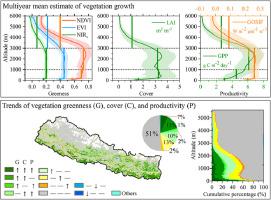
Mountain ecosystems provide multiple ecosystem services and are “natural laboratories” to understand ecosystem responses to global change. Because of the inaccessibility and the high cost of field surveys, remote sensing indices are the major and sometimes the only measures to monitor the vegetation growth dynamics in mountains. However, there are large discrepancies in those indices that should be quantified in mountainous regions. This case study in Nepal, a highly mountainous region, explores the consistency and inconsistency of six widely used remote sensing indices in monitoring vegetation growth from 2000 to 2020. The study considers three greenness indices of normalized difference vegetation indices (NDVI), enhanced vegetation index (EVI), and near-infrared reflectance of vegetation (NIRv), one cover index of leaf area index (LAI), and two productivity indices of gross primary productivity (GPP) and solar-induced chlorophyll fluorescence (SIF). We find high spatial consistency in the multiyear means (r = 0.79∼1, N = 4300, p < 0.01), especially in the highlands and between EVI and NIRv, and a logarithmic relationship between greenness indices or GOSIF and LAI or GPP. In contrast, the long-term trends differ substantially by index and space. Only 7% of the lands show synchronized significant increase though all the indices show a widespread increasing tendency (77∼87% of the lands). The prevalent non-significant changes of all the indices primarily contribute to the trend uncertainties, especially in the highlands. The inconsistencies between greenness and productivity indices and in them further exaggerate the uncertainties. Our results emphasize the large discrepancies of remote sensing indices in quantifying mountain vegetation growth dynamics. Larger inconsistency is expected if we consider disparities among the quality-control schemes, study seasons, remote sensing models, satellite platforms, and sensors. Reinforced remote sensing data, model improvements and/or new indices are needed for an accurate quantification of the vegetation growth dynamics in mountain regions.
中文翻译:
表征尼泊尔植被生长动态的遥感指数之间的巨大差异
山地生态系统提供多种生态系统服务,是了解生态系统对全球变化响应的“天然实验室”。由于野外调查的不便性和高成本,遥感指数是监测山区植被生长动态的主要措施,有时甚至是唯一的措施。然而,山区应量化的指标存在较大差异。本案例研究在尼泊尔这一高山地区进行,探讨了 2000 年至 2020 年监测植被生长的六个广泛使用的遥感指数的一致性和不一致性。该研究考虑了归一化差分植被指数 (NDVI)、增强型植被指数这三个绿色指数(EVI),以及植被的近红外反射率 (NIR v),叶面积指数 (LAI) 的一个覆盖指数,以及总初级生产力 (GPP) 和太阳诱导的叶绿素荧光 (SIF) 两个生产力指数。我们发现多年平均值具有高空间一致性(r = 0.79∼1,N = 4300,p < 0.01),尤其是在高地以及 EVI 和 NIR v之间,以及绿色指数或 GOSIF 与 LAI 或 GPP 之间的对数关系。相比之下,长期趋势因指数和空间而异。尽管所有指标都显示出广泛的增长趋势(77∼87% 的土地),但只有 7% 的土地显示出同步显着增长。所有指数普遍的非显着变化主要导致趋势的不确定性,尤其是在高地。绿色度和生产力指数之间的不一致进一步加剧了不确定性。我们的结果强调了遥感指数在量化山地植被生长动态方面的巨大差异。如果我们考虑质量控制方案、研究季节、遥感模型、卫星平台和传感器之间的差异,预计会出现更大的不一致。


 京公网安备 11010802027423号