Journal of Hydrology ( IF 5.9 ) Pub Date : 2023-05-29 , DOI: 10.1016/j.jhydrol.2023.129737 Pengfei Gu , Aimin Liao , Hongwei Liu , Wei Wu , Yongxiang Wu , Guodong Liu , Jianan Cao , Gaoxu Wang , Xi Jiang , Pengcheng Hu
|
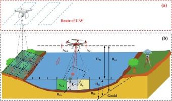
Accurate river cross-section (RCS) data is critical for hydrological research and applications; however, in most rivers, hydrographic stations are extremely limited and RCS data are scarce. A new method for mobile measurements of RCS is herein proposed based on an unreviewed aerial vehicle (UAV) platform, i.e., using UAV aerial survey to obtain above-water cross-sections and a self-made UAV bathymetric instrument to attain underwater cross-sections. Underwater cross-sectional measurement is the focus of this paper, namely UAV bathymetry (UAVB). The effectiveness of this method has been verified in rivers with different widths, water depths, turbidity, and flow velocities. The results show that the UAVB cross-section is consistent with the underwater cross-section measured in the field via conventional surveying. The surface velocity is the main factor affecting the accuracy of UAVB, and the corresponding measurement accuracy is ~4%, ~8%, and ~18% of the actual water depth when the surface velocity is less than 1 m/s, 1–2 m/s, and greater than 2 m/s, respectively. From the combination of hydraulic parameters obtained by UAV aerial survey and the calculated discharge results of three types of RCSs (measured cross-section, UAVB cross-section, and generalized cross-section), our results indicate that discharge calculated from the measured cross-section has the highest accuracy with a mean relative error (MRE) of ~5%, followed by the UAVB cross-section with MRE of ~15%, and the generalized cross-section has the worst accuracy with MRE ~35%.
中文翻译:
使用未经审查的飞行器和改进的测深仪器进行河流横断面测量
准确的河流断面(RCS)数据对于水文研究和应用至关重要;然而,在大多数河流中,水文测站极其有限,RCS 数据也很少。提出一种基于无人机平台的RCS移动测量新方法,即利用无人机航测获取水面剖面,利用自制无人机测深仪获取水下剖面。 。水下断面测量是本文的重点,即无人机测深(UAVB)。在不同宽度、水深、浊度、流速的河流中验证了该方法的有效性。结果表明,UAVB剖面与现场常规测量水下剖面一致。表面速度是影响UAVB精度的主要因素,当表面速度小于1 m/s时,对应的测量精度为实际水深的~4%、~8%、~18%,1–分别为 2 m/s 和大于 2 m/s。结合无人机航测获得的水力参数和三种类型RCS(实测断面、UAVB断面和广义断面)的计算流量结果,我们的结果表明,根据实测断面计算的流量断面精度最高,平均相对误差(MRE)为~5%,其次是UAVB断面,MRE为~15%,广义断面精度最差,MRE为~35%。当表面速度小于1 m/s、1~2 m/s和大于2 m/s时,分别为实际水深的~18%。结合无人机航测获得的水力参数和三种类型RCS(实测断面、UAVB断面和广义断面)的计算流量结果,我们的结果表明,根据实测断面计算的流量断面精度最高,平均相对误差(MRE)为~5%,其次是UAVB断面,MRE为~15%,广义断面精度最差,MRE为~35%。当表面速度小于1 m/s、1~2 m/s和大于2 m/s时,分别为实际水深的~18%。结合无人机航测获得的水力参数和三种类型RCS(实测断面、UAVB断面和广义断面)的计算流量结果,我们的结果表明,根据实测断面计算的流量断面精度最高,平均相对误差(MRE)为~5%,其次是UAVB断面,MRE为~15%,广义断面精度最差,MRE为~35%。


 京公网安备 11010802027423号