Land Use Policy ( IF 6.0 ) Pub Date : 2023-05-15 , DOI: 10.1016/j.landusepol.2023.106729 Yanjun Guan , Juan Wang , Wei Zhou , Zhongke Bai , Yingui Cao
|
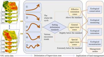
The rational delimitation of supervision zones is an important means of regional management that can effectively solve the problem of unbalanced development among reclaimed coal mine areas. In this study, 32 years of vegetation fractional coverage (VFC) series data from 1989 to 2020 were obtained for the area around the Pingshuo opencast coal mine. Then, the S-logistic function was applied to fit the VFC series data for each reclamation dump unit. Combined with the recognition results of coal mining and land reclamation years and by setting three delimitation criteria, the supervision zones of land reclamation that need to be better managed in the reclaimed dump sites were delimited. Finally, optimization revisions of the land reclamation management mode were proposed. The results showed that the effective reclamation zones of land reclamation occupied most of the study area, especially in the early reclaimed west dump, south dump and inner dump I areas of the Antaibao coal mine. The level one supervision zones, which were delineated as the general management zones, were mainly concentrated in the Anjialing inner dump, Nansigou dump, east dump, and west dump. The level two supervision zones, which were delineated as special management zones, were mainly concentrated in the Anjialing Nansigou dump site. Moreover, the Pingshuo coal mine dump sites were divided into four mode areas, namely, ecological conservation, ecological monitoring, ecological restoration, and ecological reconstruction, for the revision of land reclamation management. The proportion of area corresponding to each management mode was 49 %, 23 %, 24 % and 4 %, respectively. The management modes applicable to different reclaimed dump sites differed, and the specific management measures to be adopted depend on the succession pattern of the whole processes of rehabilitated vegetation. This study provides a new approach for delimitating the supervision zones of land reclamation and proposes revision management modes for the precise implementation of land reclamation development plans in coal mining areas.
中文翻译:
划定监管区为煤矿区土地复垦管理模式修订提供依据:基于恢复植被演替特征的视角
合理划定监管区是区域管理的重要手段,可以有效解决复垦煤矿区之间发展不平衡的问题。本研究获取了平朔露天煤矿周边地区1989-2020年32年的植被覆盖度(VFC)系列数据。然后,应用 S-logistic 函数对每个填海转储单元的 VFC 系列数据进行拟合。结合煤炭开采和土地复垦年份认定结果,通过设定三项划定标准,对填埋场划定了需要加强管理的土地复垦监管区。最后提出了土地复垦管理模式的优化修正。结果表明,土地复垦的有效复垦区占据了研究区的大部分,尤其是安太堡煤矿早期复垦的西排场、南排场和内排场I区。划定为综合管理区的一级监管区主要集中在安家岭内垃圾场、南四沟垃圾场、东垃圾场和西垃圾场。划定为特别管理区的二级监管区主要集中在安家岭南寺沟垃圾场。此外,将平朔煤矿排土场划分为生态保护、生态监测、生态修复和生态重建四个模式区,进行土地复垦管理修订。每种经营模式对应的面积比例分别为49%、23%、分别为 24% 和 4%。不同的填埋场适用的管理模式不同,具体采取的管理措施取决于植被修复全过程的演替模式。该研究为土地复垦监管区的划定提供了新思路,为煤矿区土地复垦开发规划的精准实施提出了修订管理模式。


 京公网安备 11010802027423号