当前位置:
X-MOL 学术
›
Sci. Total Environ.
›
论文详情
Our official English website, www.x-mol.net, welcomes your
feedback! (Note: you will need to create a separate account there.)
Forecasting wheat and barley crop production in arid and semi-arid regions using remotely sensed primary productivity and crop phenology: A case study in Iraq
Science of the Total Environment ( IF 8.2 ) Pub Date : 2017-09-12 , DOI: 10.1016/j.scitotenv.2017.09.057 Sarchil Hama Qader , Jadunandan Dash , Peter M. Atkinson
Science of the Total Environment ( IF 8.2 ) Pub Date : 2017-09-12 , DOI: 10.1016/j.scitotenv.2017.09.057 Sarchil Hama Qader , Jadunandan Dash , Peter M. Atkinson
|
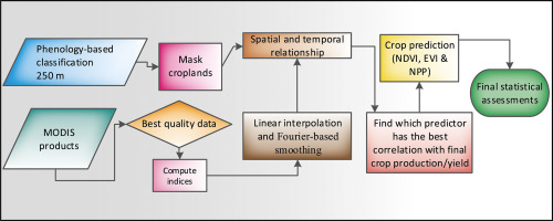
Crop production and yield estimation using remotely sensed data have been studied widely, but such information is generally scarce in arid and semi-arid regions. In these regions, inter-annual variation in climatic factors (such as rainfall) combined with anthropogenic factors (such as civil war) pose major risks to food security. Thus, an operational crop production estimation and forecasting system is required to help decision-makers to make early estimates of potential food availability. Data from NASA's MODIS with official crop statistics were combined to develop an empirical regression-based model to forecast winter wheat and barley production in Iraq. The study explores remotely sensed indices representing crop productivity over the crop growing season to find the optimal correlation with crop production. The potential of three different remotely sensed indices, and information related to the phenology of crops, for forecasting crop production at the governorate level was tested and their results were validated using the leave-one-year-out approach. Despite testing several methodological approaches, and extensive spatio-temporal analysis, this paper depicts the difficulty in estimating crop yield on an annual base using current satellite low-resolution data. However, more precise estimates of crop production were possible. The result of the current research implies that the date of the maximum vegetation index (VI) offered the most accurate forecast of crop production with an average R2 = 0.70 compared to the date of MODIS EVI (Avg R2 = 0.68) and a NPP (Avg R2 = 0.66). When winter wheat and barley production were forecasted using NDVI, EVI and NPP and compared to official statistics, the relative error ranged from − 20 to 20%, − 45 to 28% and − 48 to 22%, respectively. The research indicated that remotely sensed indices could characterize and forecast crop production more accurately than simple cropping area, which was treated as a null model against which to evaluate the proposed approach.
中文翻译:

利用遥感初级生产力和作物物候预测干旱和半干旱地区的小麦和大麦作物产量:以伊拉克为例
使用遥感数据进行的农作物产量和单产估算已得到广泛研究,但是在干旱和半干旱地区这种信息通常很少。在这些地区,气候因素(如降雨)的年际变化与人为因素(如内战)相结合,对粮食安全构成重大风险。因此,需要一个可操作的农作物产量估算和预报系统,以帮助决策者对潜在的粮食供应进行早期估算。来自NASA的MODIS数据与官方作物统计数据相结合,以开发基于经验回归的模型来预测伊拉克的冬小麦和大麦产量。该研究探索了代表作物生长期的作物生产力的遥感指数,以找到与作物产量的最佳相关性。测试了三种不同的遥感指数以及与作物物候相关的信息对省级农作物产量进行预测的潜力,并使用了“一年留一法”对它们的结果进行了验证。尽管测试了几种方法论方法并进行了广泛的时空分析,但本文还是描述了使用当前的卫星低分辨率数据估算年产量的困难。但是,可以对农作物的产量进行更精确的估算。当前研究的结果表明,最大植被指数(VI)的日期提供了最准确的农作物产量预测,平均 对用于预测省级作物产量的方法进行了测试,并使用了“一年留一假”方法验证了其结果。尽管测试了几种方法论方法并进行了广泛的时空分析,但本文还是描述了使用当前的卫星低分辨率数据估算年产量的困难。但是,可以对农作物的产量进行更精确的估算。当前研究的结果表明,最大植被指数(VI)的日期提供了最准确的农作物产量预测,平均 对用于预测省级作物产量的方法进行了测试,并使用了“一年留一假”方法验证了其结果。尽管测试了几种方法论方法并进行了广泛的时空分析,但本文还是描述了使用当前的卫星低分辨率数据估算年产量的困难。但是,可以对农作物的产量进行更精确的估算。当前研究的结果表明,最大植被指数(VI)的日期提供了最准确的农作物产量预测,平均 可以对作物产量进行更精确的估算。当前研究的结果表明,最大植被指数(VI)的日期提供了最准确的农作物产量预测,平均 可以对作物产量进行更精确的估算。当前研究的结果表明,最大植被指数(VI)的日期提供了最准确的农作物产量预测,平均 与MODIS EVI(平均R 2 = 0.68)和NPP(平均R 2 = 0.66)的日期相比,R 2 = 0.70 。当使用NDVI,EVI和NPP预测冬小麦和大麦产量并与官方统计数据进行比较时,相对误差分别为− 20%至20%,− 45%至28%和−48%至22%。研究表明,与简单种植面积相比,遥感指数可以更准确地表征和预测作物产量,后者被视为评估该方法的无效模型。
更新日期:2017-09-13
中文翻译:
利用遥感初级生产力和作物物候预测干旱和半干旱地区的小麦和大麦作物产量:以伊拉克为例
使用遥感数据进行的农作物产量和单产估算已得到广泛研究,但是在干旱和半干旱地区这种信息通常很少。在这些地区,气候因素(如降雨)的年际变化与人为因素(如内战)相结合,对粮食安全构成重大风险。因此,需要一个可操作的农作物产量估算和预报系统,以帮助决策者对潜在的粮食供应进行早期估算。来自NASA的MODIS数据与官方作物统计数据相结合,以开发基于经验回归的模型来预测伊拉克的冬小麦和大麦产量。该研究探索了代表作物生长期的作物生产力的遥感指数,以找到与作物产量的最佳相关性。测试了三种不同的遥感指数以及与作物物候相关的信息对省级农作物产量进行预测的潜力,并使用了“一年留一法”对它们的结果进行了验证。尽管测试了几种方法论方法并进行了广泛的时空分析,但本文还是描述了使用当前的卫星低分辨率数据估算年产量的困难。但是,可以对农作物的产量进行更精确的估算。当前研究的结果表明,最大植被指数(VI)的日期提供了最准确的农作物产量预测,平均 对用于预测省级作物产量的方法进行了测试,并使用了“一年留一假”方法验证了其结果。尽管测试了几种方法论方法并进行了广泛的时空分析,但本文还是描述了使用当前的卫星低分辨率数据估算年产量的困难。但是,可以对农作物的产量进行更精确的估算。当前研究的结果表明,最大植被指数(VI)的日期提供了最准确的农作物产量预测,平均 对用于预测省级作物产量的方法进行了测试,并使用了“一年留一假”方法验证了其结果。尽管测试了几种方法论方法并进行了广泛的时空分析,但本文还是描述了使用当前的卫星低分辨率数据估算年产量的困难。但是,可以对农作物的产量进行更精确的估算。当前研究的结果表明,最大植被指数(VI)的日期提供了最准确的农作物产量预测,平均 可以对作物产量进行更精确的估算。当前研究的结果表明,最大植被指数(VI)的日期提供了最准确的农作物产量预测,平均 可以对作物产量进行更精确的估算。当前研究的结果表明,最大植被指数(VI)的日期提供了最准确的农作物产量预测,平均 与MODIS EVI(平均R 2 = 0.68)和NPP(平均R 2 = 0.66)的日期相比,R 2 = 0.70 。当使用NDVI,EVI和NPP预测冬小麦和大麦产量并与官方统计数据进行比较时,相对误差分别为− 20%至20%,− 45%至28%和−48%至22%。研究表明,与简单种植面积相比,遥感指数可以更准确地表征和预测作物产量,后者被视为评估该方法的无效模型。


 京公网安备 11010802027423号