
Bridging Geospatial and Semantic Worlds: Enhancing Analysis of Place-Based Concepts in GIS


1
Department of Geospatial Information Systems, K. N. Toosi University of Technology, Tehran 19967-15433, Iran
2
Department of Pathology, Microbiology, and Immunology, School of Veterinary Medicine, University of California, Davis, CA 90616, USA
3
Department of Civil, Environmental Engineering, and Architecture (DICAAR), University of Cagliari, 09124 Cagliari, Italy
*
Authors to whom correspondence should be addressed.
Land 2024, 13(3), 377; https://doi.org/10.3390/land13030377
Submission received: 11 February 2024
/
Revised: 9 March 2024
/
Accepted: 12 March 2024
/
Published: 16 March 2024
(This article belongs to the Section Land Planning and Landscape Architecture)
Abstract
:People’s actions and behaviours contribute to the diversity and personality of a space, transforming it into a vibrant and thriving living environment. The main goal of this research is to present a GIS-based framework for assessing places. The framework is constructed based on the idea of conceptual spaces, integrating spatial and semantic concepts inside a geometric structure. The explanation of place-related concepts is achieved via the use of linear programming and convex polytopes. By projecting these concepts into the spatial domain, a strong connection between geographical and semantic space is established. This connection allows a wide range of analytical calculations using geographic information systems to be carried out. The study focuses on the sense of city centre in Tehran, Iran, by employing questionnaires administrated on-site to evaluate the correlation between identified city centres and the participants’ responses. The findings demonstrate a good correlation, as shown by a Pearson correlation value of 0.74 and a rank correlation coefficient of 0.8. Interestingly, the city centres that were selected did not always align with the geographic centre. However, participants still perceived them as city centres. This framework serves as a valuable tool for planners and policymakers, providing a comprehensive understanding of the built environment. By considering both semantic and geographical aspects, the framework emphasises the importance of emotions, memories, and meanings in creating an inclusive environment.
1. Introduction
In the field of Geographic Information Science (GIScience), space refers to the physical location, size, shape, and distances between objects on the Earth [1,2,3]. It provides the physical setting where human activities happen [4]. Spatial analyses focus on numeric qualities that can be measured, such as proximity, dispersion, and density analysis. However, place encompasses the subjective emotions, memories, and meanings that people associate with a location [5]. Place evolves through human experiences, relationships, and memories [6]. In other words, place is how people make space meaningful through their activities. A childhood home, for example, may have sentimental value and generate happy memories, but a trauma site may stimulate negative feelings. The meaning of a place can also fluctuate throughout time as individuals’ and societies’ values and priorities shift. The idea of place is more than just identifying a spot on a map. Instead, it considers how people actively shape and give meaning to locations through real experiences and interactions. The semantics of a place is shaped by the social and cultural practices of those who live in it rather than being inherent in its physical qualities [7].
In recent years, the concept of place has gained significant attention in GIScience. An important factor is the increase in user-generated geographic data, which captures perspectives on everyday experiences of place. However, there is still no agreement within GIScience on the best approach for modelling and analysing places [8]. Although the significance of place is increasingly acknowledged, there is still a need for effective computational methods for modelling it [7]. There is a need for new models that can combine the human-centred qualities of place with the mathematical methods used in GIScience. A substantial percentage of the current research on incorporating place into GIS has mostly focused on exploration, without established frameworks or methodologies. This demonstrates that there is still not much consensus among GIS experts about how to characterise the idea of place in a manner that is compatible with spatial data tools. The ongoing exploration of place-related research underscores the unresolved nature of modelling place using GIS.
Due to the concepts pertaining to space, place, and related topics are prevalent in numerous academic disciplines; therefore, it is helpful to fully explain the specific way in which the authors use these notion in this study. Table 1 provides definitions of the key spatial terms utilised throughout the manuscript, in order to establish the terminology employed by the authors.
Places are extensively investigated in other related subjects such as human geography [10,12,13,14], urban science [15,16,17], and philosophy [18]; however, they offer computational challenges in GIScience due to their complex nature [19]. Recently, GIScience has become more connected to people due to the development of volunteered geospatial information (VGI), the popularity of social networks, and the ease of sharing location [20,21]. Merschdorf and Blaschke [22] divided GIScience research into eight categories: critical GIS, qualitative GIS, participatory GIS (PGIS), volunteered geospatial data, crowdsourcing, ontology, semantics, and place names and modelling. Blaschke, et al. [7] emphasised the necessity of place modelling, building new computational data models, and adapting spatial operations to place-based ones, due to the inefficiency of GIS in dealing with ambiguous data.
In recent years, there have been some efforts made to address the aforementioned lack [23]. Papadakis, et al. [24] proposed a model that bridges space and place. Their suggested framework modelled a place from four perspectives: where it is, what it offers, what is in it, and how big it is. Their method sought to combine how a place is understand in both its physical characteristics and our experiences of it, all within a structured framework. Cho and Yuan [25] established a formal connection between events that are made possible by a place and how a place is formed. The values of places derive from the events associated with them, and when certain event clusters happen repeatedly, unique connections are forged between places and activities. Their approach provides a way to express the experiential characteristics that distinguish spaces and give them significance as places. Davies [26] introduced a place model that involves overlaying a mental semantic space onto geographic space. Within the proposed framework, places are characterised by the combination of a specific location and its corresponding sensory-motor attributes. This model uses the technique of superimposing mental images onto real locations to create a computational representation of qualitative elements that differentiate ordinary spaces from meaningful ones. Their approach encompasses the multidimensional identity of places by bridging geographic information with intangible dimensions of meaning and experience.
Place-based analysis is associated with the authors’ understanding of the built environment as well as their sense of belonging to that place. Brown, et al. [27] used minimum convex polygons to map people’s perceptions in South Australia through collected field survey data. Participants were asked to mark where they live and choose at least three points outlining an area that best represents their daily life, work preferences and their feelings and memories. Maguire and Klinkenberg [28] developed the place analysis system (PAS), a tool designed to collect, store, visualise, and analyse people’s collected memories and perceptions associated with the park in Canada. Diener and Hagen [29] proposed a model that combined physical features and memories. To obtain a holistic understanding of place-based analysis, they utilised ideas from experts from different branches of geography.
This paper introduces a computational framework for representing and analysing place-based concepts in GIS. The framework incorporates the elements of the theory of conceptual spaces, such as quality dimensions, convex regions, prototypes, and instances, as the core of its structure. The theory is formalised with the help of convex polytopes. As a case study, the authors depict the city-centre-like neighbourhoods of the city of Tehran. The study aims to investigate how the place-based analysis approach integrates individual memories and perceptions with spatial data in GIS to comprehend human-related aspects in geographical contexts. This was achieved by utilising convex polytopes to transfer memories and perceptions directly into the GIS, as demonstrated in a case study conducted in Tehran. This research tackles the inquiry of integrating perceptions into current GIS systems and offers a straightforward solution to connect the realms of meaning and physical space.
The contribution of the present study is the development of a holistic approach that integrates spatial features with people’s real-world perceptions gathered from the field, for a comprehensive understanding. In contrast to the traditional perspective of GIS, which mainly focuses on displaying physical features, this research demonstrates how perceptions and memories can be seamlessly integrated with these physical features, emphasising the importance of a more inclusive and human-centric approach in geographic information systems that the authors of this study call place-based analysis.
The present research has significant real-world implications by enhancing GIS capabilities for representing and analysing place-based concepts, while also making important theoretical contributions to bridge the gap between GIScience and the humanistic study of place. The integration of computational and humanistic perspectives could highly benefit fields grappling with the complexities of place.
2. Materials and Methods
2.1. Study Area
Tehran is among the largest and fastest-growing cities in the Middle East. According to the official estimation conducted by the Management and Planning Organisation (MPO) of Iran, the population of the city in 2023 is over 9 million people [30]. Tehran has the highest level of urban population in Iran [31]. With an area of over 700 km2, it is situated in the southern parts of the Alborz Mountain range. From a socio-economic perspective, Tehran is divided into a north–south partition [32]. It is a vibrant metropolis that is home to a wide range of ethnicities and traditions. As a bustling capital city, Tehran has a diversity of neighbourhoods and urban spaces with distinct identities and social significance. Since the 1950s, Tehran has experienced rapid population growth and urban expansion, resulting in considerable changes to its urban landscape [33]. However, Tehran’s geography, culture, and policies have moderated some of the impacts of urbanisation. Preservation initiatives, like those at the Grand Bazaar, have successfully maintained cultural and traditional identity in spite of modernisation pressures [34]. However, removing height restrictions on new buildings has significantly changed Tehran’s skyline, introducing more high-rise structures [35]. Overall, while urbanisation has been substantial, various geographic, cultural, and regulatory factors have mediated the changes to Tehran’s urban form and spatial identity. Numerous museums, palaces, and historical sites showcase the city’s rich history and culture. The city’s meaning has also been formed through its inhabitants’ social and cultural habits [36]. The city is experiencing fast urbanisation and spatial transformation, which highlights the need to conceptualise some important place-based concepts. As the city grows, the meanings and identities associated with its spaces evolve. Furthermore, by collecting information from resident surveys and interviews, and analysing the geospatial data, the authors can confirm that their theories about place-based spaces, such as the city centre, are supported by the authentic perceptions of the inhabitants. In other words, by talking to people who live in the study area through surveys and interviews, and using maps and location data, authors can verify the alignment between their ideas about different places and the perspectives of the local population.
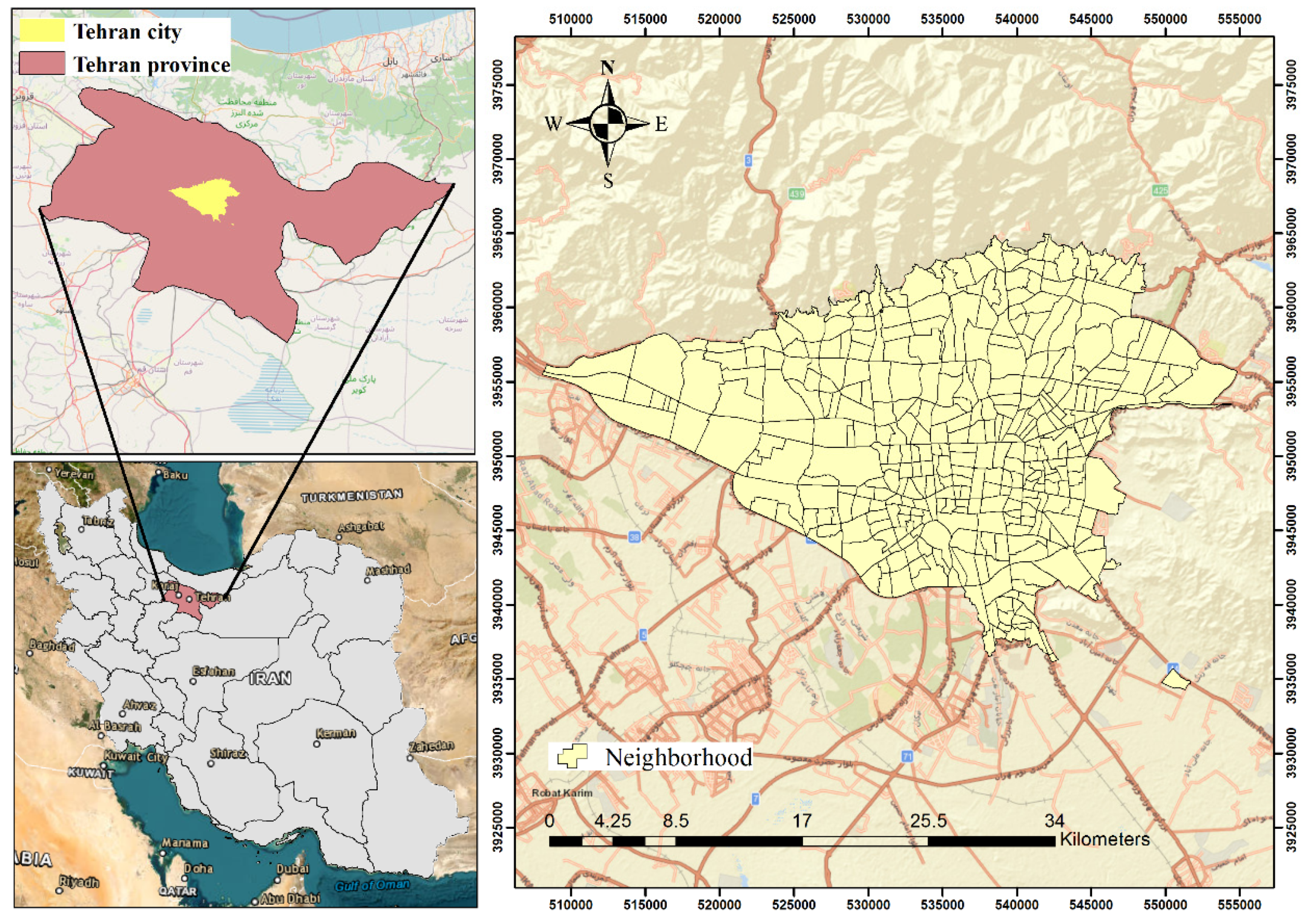
Figure 1 illustrates the location of Tehran province in Iran, and the location of Tehran city in the province, along with the neighbourhoods that comprise it.
2.2. Data Collection
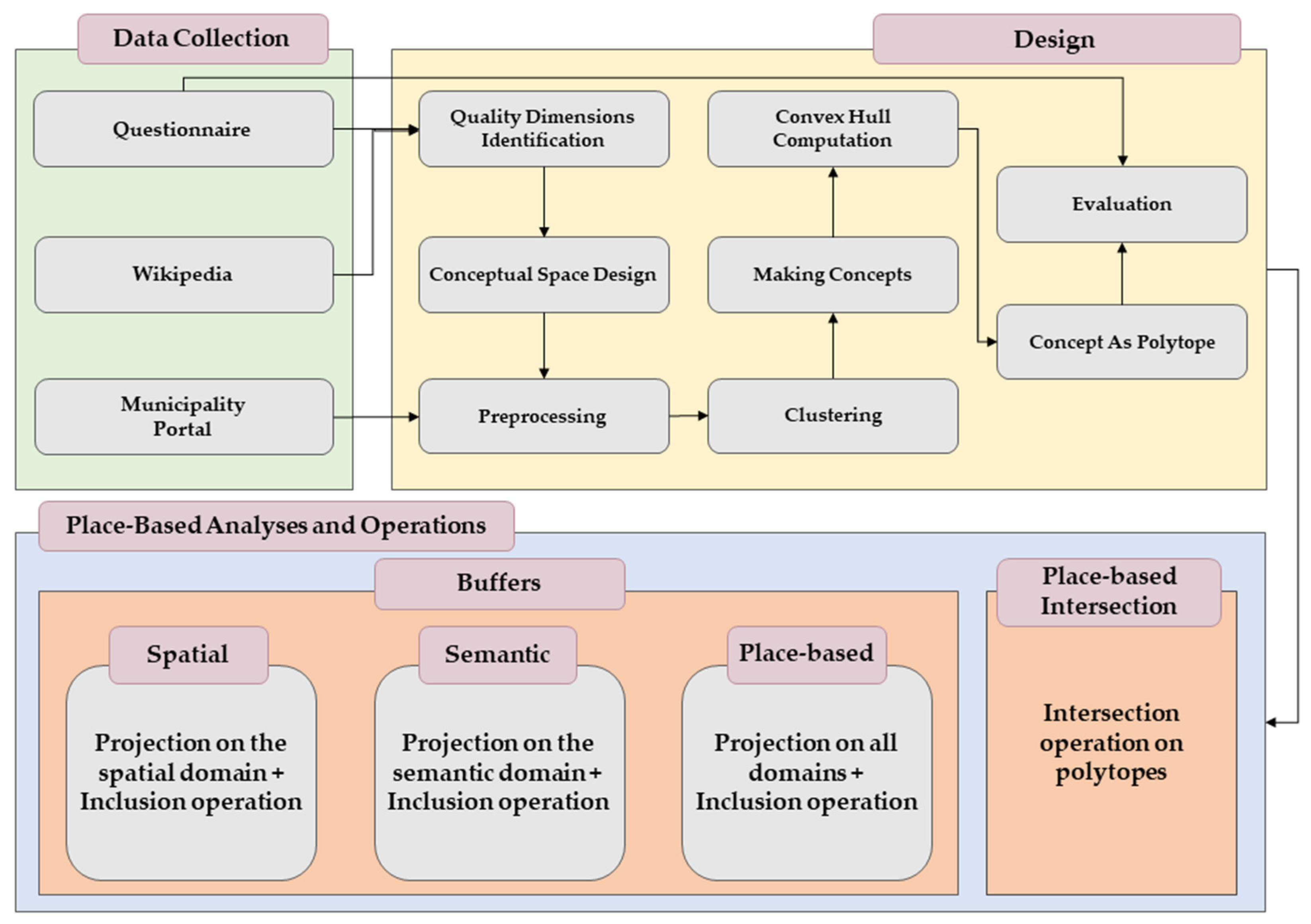
Figure 2 presents the overall workflow and research design of the study. The workflow steps are delineated below, and a detailed review of each step is provided in Section 2.2 and Section 2.3.
- Wikipedia definition—The first stage involved a definition of “city centre” from the Persian Wikipedia page, in order to obtain a preliminary understanding of the concept’s meaning in the local Iranian context.
- Questionnaire—A questionnaire was developed based on the definition of Wikipedia. The purpose of this survey was to collect opinions from inhabitants of Tehran about their perceptions of the city centre. The objective is to validate and enrich the understanding provided by the Wikipedia definition.
- Quality dimensions—From the survey results, key quality dimensions (i.e., the features) associated with the city centre concept were identified. It is the first, key step in designing a conceptual space.
- Formalisation—The quality dimensions were translated, along with spatial dimensions, into a conceptual space using convex polytopes.
- Instance collection—Instances of Tehran neighbourhoods are displayed as points within the conceptual space based on their measured qualities.
- Clustering—A k-means clustering algorithm was applied to group similar neighbourhood instances into concepts explaining city centres.
- Evaluation—Finally, the neighbourhood classifications were evaluated by correlating them with the original survey results to validate the approach.
First, a simple definition of city centres on the Wikipedia platform was conducted. Due to the culture variations in the definitions of places, the Persian article (titled شهر مرکز, city center in English) was used to obtain a local definition of the study area. According to the article’s definition, “In Iran, the city centre term is used in traffic signs on the streets and roads, but the city centre usually does not have a definite boundary”. The Bazaar and its surrounding districts have traditionally been considered the centre of Iranian cities. The city core of Tehran has special traffic legislation, such as traffic plan regulations [37]. The definition provides essential information on the qualities of a city centre in Iran. The boundaries are not distinguishable; it includes a bazaar that is almost always bustling and forms the city’s old core, displaying historical elements of a city centre. Aside from consulting Wikipedia, the authors reviewed some academic papers related to the study of city centres in Iran. Table 2 provides an overview of the reviewed papers and the characteristics of the city centres in Iran according to them.
The majority of information about places can be obtained through social media or from direct enquiries to people [43]. A questionnaire was developed to validate the definition retrieved from the Wikipedia page. Tehran residents were required to explain their mental image of the city core. The survey participants consisted of individuals spanning various age groups, encompassing teenagers through senior citizens. To ensure a balanced distribution of genders in the survey results, both males and females were included. The criterion for selecting participants was that they were either citizens of Tehran or had resided there for a minimum of ten years. Additionally, efforts were made to include individuals residing in different areas of the city to ensure an equal distribution among respondents. Instead of relying on a convenience sampling method, the approach of this research was to achieve a spatially balanced, random sample that included all 22 municipal districts of Tehran. The authors ensured representation by conducting surveys with at least 10 respondents from each district. The objective was to gather perspectives from residents across the entire city, avoiding a focus on easily accessible or overrepresented areas. The survey focused on soliciting participants’ identification of elements present in a prototypical city centre. Additionally, official urban datasets were used from Tehran’s Municipality to quantify the features of the city centre. The dataset contains historical structures, traffic and transportation, and land use data. The dataset is hosted on the Tehran Municipality’s official geoportal [44].
2.3. Design
2.3.1. Quality Dimensions Identification
In a conceptual space, a quality dimension refers to an object or concept’s distinct attribute or characteristic, providing a structured framework for explaining meaning, memories and emotions. In a formal sense, a quality dimension is defined as follows:
Definition 1.
A quality dimension is defined as where indicates the scale of the dimension, denotes the range of the dimension, and is a Boolean indicating whether the dimension is circular.
The questionnaire is an effective tool for identifying the quality dimensions associated with city centres. A unanimous consensus was reached among all respondents (100%) that city centres possess historical significance. Additionally, a significant percentage of participants (92%) acknowledged being crowded, while 75% recognised the importance of easy accessibility. Furthermore, 71% of respondents emphasised the presence of numerous shopping opportunities within city centres. Based on these findings, three distinct quality dimensions were identified: historical, commercial, and accessibility dimensions. To compensate for the limited availability of data on the city’s specific demographics, accessibility was used also as a proxy variable to approximate the distribution of individuals in the area. These dimensions form the semantic domain within the conceptual space, providing a comprehensive framework for understanding the characteristics of city centres. The quality dimensions identified through the questionnaires are then combined with two additional dimensions explaining the spatial domain (latitude and longitude) to create a Cartesian conceptual space that enables the integration of, and transformation between, the spatial domain and the semantics. The objective of using the spatial dimensions as quality dimensions of a place are twofold. Firstly, from a cognitive perspective, a place connotes its underlying space [45]. Secondly and equally important, the spatial dimension enables the bridging of semantics with space, which is crucial in integrating place-based functionalities with the existing GIS operations.
2.3.2. Conceptual Space Design
A conceptual space is a similarity space spanned by a set of quality dimensions. Formally, a conceptual space is composed of a set of domains.
Definition 2.
A domain is defined as a set of quality dimensions. Domains can be considered as categories in which quality dimensions are grouped. The set of all domains in a conceptual space is denoted by Δ. In this study, the semantic domain is comprised of three quality dimensions, namely historical, commercial, and accessibility dimensions. The spatial domain is comprised of two geographical coordinates. The set of all quality dimensions is considered in this study as place-based domain.
Definition 3.
A concept is defined as , where denotes a set of convex regions in the space. indicates a prototype of the concept in the space. The prototype instance of the concept is assumed to be a point in the space, theoretically located in the centre of the convex region explaining the concept.
2.3.3. Preprocessing
Data preparation is frequently required before building a conceptual space. Depending on the nature of the data and the desired explanation, the specific preparation processes may differ. They may entail filtering, removing duplicates, correcting missing values, and addressing data inconsistencies to remove noise, outliers, or unnecessary data points that may distort the meanings. Furthermore, normalising the data ensures consistent values across many quality dimensions. Normalisation approaches commonly used include z-score normalisation, min–max scaling, and feature scaling [46]. Appropriate encoding techniques, such as one-hot encoding [47], label encoding [48], or other approaches [49], are necessary to translate them into numerical values that may be employed in creating the conceptual space.
2.3.4. Instances of Places
In conceptual spaces, instances relate to individual objects that are explained within the conceptual space. An instance is produced when a value is found for all quality dimensions in the space. Within a conceptual space of places, instances may encompass city neighbourhoods, monuments, parks, cinemas, or any other entity associated with a specific place.
Definition 4.
A property is defined as a concept in one domain, namely, when . Properties can be understood as seeing a concept from only one aspect.
Definition 5.
An instance is basically a point in a conceptual space, symbolising an object in the real world.
2.3.5. Concept as Polytope
Expressing concepts as convex polytopes simplifies certain actions in conceptual spaces, making them equivalent to familiar operations performed on convex polytopes. In other words, the proposed framework employs convex polytopes to define boundaries produced by connecting the points (instances) collected from people’s perceptions.
A polytope is expressed in multiple ways. A polytope defined by its vertices (i.e., its convex hull) is called a V-polytope. Alternatively, a polytope can be described by its facets, and in this case, it is called an H-polytope. Some operations are more conveniently performed with H-polytopes, while some others are more intuitive with V-polytopes. For example, it is simpler to find where two or more polytopes intersect when working with their facets. However, it becomes a computationally challenging problem (NP-hard) when dealing with the convex hull [50]. Conversely, linear transformations in H-polytopes may become exponential in the dimension of the polytope, but they are trivial in V-polytopes.
An H-polytope in can be written as the set of solutions to the minimal system of linear inequalities (Equation (1))
2.3.6. Evaluation
Assessing a designed conceptual space can be approached from various perspectives, depending on the specific objectives and applications of the space. One method involves collecting human judgments or assessments related to the conceptual space. This may include experiments or surveys where participants engage in tasks associated with the conceptual space, such as making similarity judgments, performing categorisation tasks, or generating concepts. The effectiveness and validity of the conceptual space are then evaluated by comparing participant responses to the expected or desired outcomes.
2.4. Place-Based Analyses and Operations
Similar to spatial analyses conducted within a GIS, a comprehensive system designed for handling places should possess the capability to analyse place-based concepts. In line with the core concept of the proposed approach, which emphasises the integration of space with its associated meaning, the authors consider place-based analyses as operations that are simultaneously applied to both the geographical space and its semantic characteristics. Place-based analyses offer a more comprehensive and nuanced understanding of the analysed concepts by considering both the geographical and semantic dimensions. By embracing this integrated perspective, the proposed approach enables a richer exploration and interpretation of places.
2.4.1. Projection
Projecting concepts onto domains or quality dimensions provides a systematic framework for understanding relationships, similarities, and differences between concepts within a specific domain. In the proposed conceptual space design, the projection of the concepts onto, for example, the spatial domain is defined as:
where and are the coordinates of points in the spatial domain, and is the normalised value of the quality dimension. The result of the above projection is the normalised spatial depiction of the concept. Then, the linear transformation from the normalised spatial domain to the geographic space is a simple reverse normalization. Equation (3), along with the linear transformation, work as a generic approach to bridge the place and space in a conceptual space. The same technique is used to depict the concepts in other, semantic, domains.
2.4.2. Inclusion
Given an H-polytope and a point , this operation checks whether is located inside the polytope. The solution to this is straightforward, as is inside the polytope if and only if it satisfies all the inequalities in the system.
2.4.3. Cross-Polytopes
As the conceptual spaces are formalised by polytopes, utilising the Euclidean metric results in non-linear geometries which are incompatible with linear inequalities generated by the formalisation. In addition, researchers have shown that in a high dimensional space, the use of ℓ1-norm distances is preferable [53]. Furthermore, psychological evidence suggests that similarities are perceptually better grasped by city-block metrics [54]. A cross-polytope, as an appropriate approximation of n-spheres, helps measure distances in conceptual spaces. A cross-polytope is the closed unit ball in the ℓ1-norm and is defined as
where denotes the ℓ1-norm of .
2.4.4. Intersection
The intersection of two (or more) convex polytopes can be written as the concatenation of their corresponding linear inequality systems [55]. This might lead to redundant inequalities in the system, which have to be removed. Suppose is an H-polytope composed of inequalities. If implies , then defines a redundant half-space and can be removed from the system using linear programming.
2.4.5. Voronoi Diagram
A Voronoi diagram decomposes a space containing a finite set of points into different nearest neighbourhoods [56]. Let X be a metric space and be a set of k points in the space. The Voronoi cell or Voronoi region associated with the set is the set of all points in X whose distance to is not greater than their distance to the other points where . In other words
where d is the distance function defined on the space. Voronoi diagrams are used in the definition of a place-based buffer in this paper.
2.4.6. Buffers
Spatial buffers, also known as buffer zones, play a critical role in spatial analysis and GIS. A spatial buffer can be defined as an area surrounding a specific geographic feature or point of interest, typically measured in distance units [57]. The application of spatial buffers provides a valuable analytical framework for understanding spatial relationships and supporting evidence-based decision-making in a wide range of disciplines.
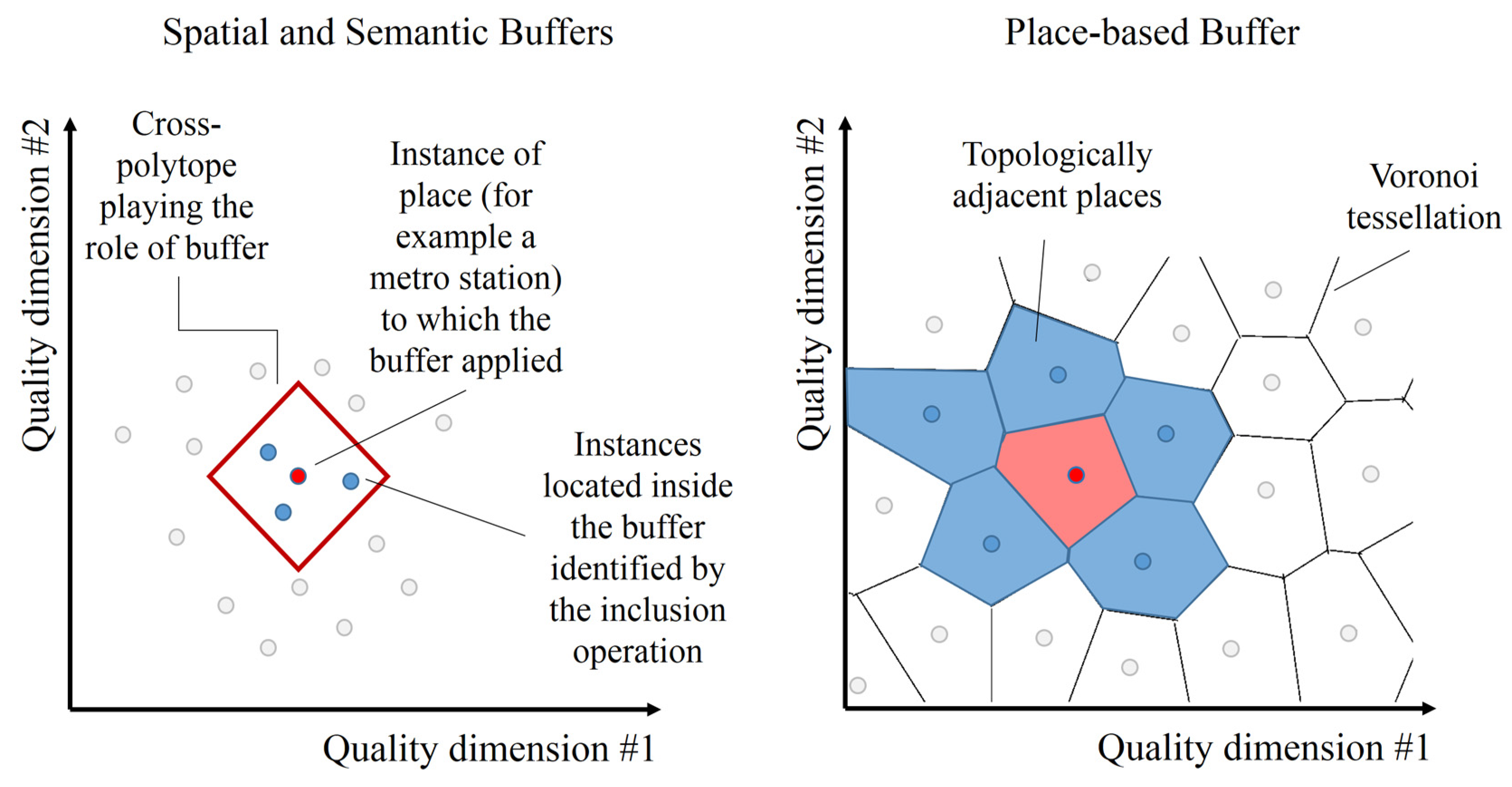
In this study, the authors propose three types of buffers enabled by our proposed framework, including spatial, semantic, and place-based buffers. The buffers are defined as follows:
- Spatial buffer: Identifies places located at a particular distance from a target place. This analysis includes computing a cross-polytope in the spatial domain, and an inclusion operation. Alternatively, the cross-polytope can be computed in the whole space. In this case, the result can be depicted by a projection operation onto the spatial domain.
- Semantic buffer: Identifies places similar to a place, in a domain other than the spatial domain, by a particular percentage value. This analysis includes computing a cross-polytope in the non-spatial domain, and an inclusion operation.
- Place-based buffer: Identifies places semantically similar and physically close to a place. In other words, it identifies places topologically adjacent to a place within the whole conceptual space. This analysis includes computing the Voronoi diagram of the conceptual space.
Figure 3 shows a schematic depiction of the proposed buffers in conceptual spaces. In the left plot, a cross-polytope buffer for the red dot is shown. The red dot can be any instance in the conceptual space (for example, a metro station). The purpose of the buffer is to determine the other instances that are at a specific distance from the red instance. An inclusion operation on the cross-polytope and the dots can determine the instances within the buffer. The mechanism of drawing buffers is the same for both spatial and semantic domains. In this plot, it is assumed that the domain in which the buffer is applied is two-dimensional. In the right plot, a place-based buffer for the red dot is shown. The plot depicts the Voronoi diagram of all instances in the conceptual space. In this plot, it is assumed that the whole conceptual space is composed of two dimensions. As stated above, the proposed place-based buffer determines the semantically similar and geographically close instances based on the adjacency of their corresponding Voronoi cells.
2.4.7. Spatial and Semantic Intersections
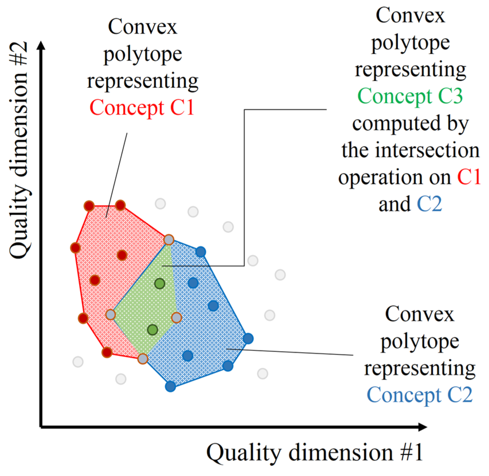
Spatial intersections constitute a core concept in GIS and spatial analysis, involving the identification and analysis of coinciding or overlapping areas among multiple spatial features or layers. These intersections are pivotal for unveiling intricate relationships and patterns within geographic data, providing researchers and planners with valuable insights into spatial phenomena. This study introduces place-based intersections, achieved through the intersection of polytopes in the conceptual space. Serving as general forms of spatial intersections, they are computed across the entire conceptual space, and the proposed representation method facilitates their convenient computation. Figure 4 illustrates the mechanism of making new concepts from intersections. In the plot, two concepts (i.e., the red and blue regions) are represented by the convex hulls of their corresponding instances. By applying an intersection operation on the two concepts, a new concept (i.e., the green region) is made. This operation can be applied to all domains and to the whole conceptual space.
3. Results
3.1. Identifying the Quality Dimensions
As previously stated, five quality dimensions were identified to represent a neighbourhood and determine its status as a city centre. These quality dimensions include the spatial coordinates (x, y) to establish the geographical location, the density of historical and cultural buildings and sites (HBD), the density of shopping centres (SCD), and the density of public transportation stops (PTD). These dimensions were selected based on their significance in capturing the essential characteristics of a neighbourhood and it potential to be classified as a city centre. Equation (6) shows the whole domain of the conceptual space, which in turn is composed of four sub-domains.
3.2. Representing Place-Based Concepts in the Conceptual Space
According to the notion of place identified in this paper, a city centre is more than just a spatial or physical/geographical term. As a result, the questions “Where is the city centre of Tehran?” and “Where are the city-centre-like neighbourhoods in Tehran?” are different, with the first being spatial and the second being place-based. The first question addresses the spatial aspect of the city centre. To address the second query, it is crucial to identify neighbourhoods that are perceived as city centres. Although individuals commonly use neighbourhood names, they are rarely employed as independent entities. More crucially, a city centre typically only corresponds to a fraction of the area. As a result, the city core is likely made up of one or more neighbourhoods. The authors intend to convey the city-centre concept in conceptual space by employing neighbourhood instances.
To represent neighbourhoods and city centres in the conceptual space, the authors asked participants to score the neighbourhoods of Tehran, ranging from 1 to 10, as if they sense them as city centres. The thresholds were optimised such that the binary classification into two classes of city and non-city centres yielded the highest F-score based on the participants’ answers. Then, a k-means algorithm was employed to encapsulate the points in clusters. The convex hull of each cluster was computed. The software, Bensolve Tools Version 1.3 [58], was used to compute the convex hull of points and construct convex polytopes. The resulting convex hulls represent the city centre concept as convex regions in the conceptual space. The H- and V-representations of the obtained polytopes are shown in Table 3.
3.3. Place-Based Analyses
As a similarity space, the notions of distance and similarity become congruent in a conceptual space. To preserve consistency with polytopes, the authors employed city block metrics in the conceptual spaces. Then, cross-polytopes are suitable options for measuring distances. Table 4 summarises the specifications of some elements defined in the constructed conceptual space.
A place-based answer to the query “Where are the city-centre-like neighbourhoods in Tehran?” is the list of neighbourhoods (instances) located within the city-centre polytope (the inclusion operation on polytopes). Table 5 shows the list of 10 neighbourhoods identified as city-centre-like. The distance between the neighbourhood instances and the prototype of the concept shows the degree of being like a city centre. In the third column, the average similarity of the neighbourhoods to the city centre as evaluated by the participants is shown.
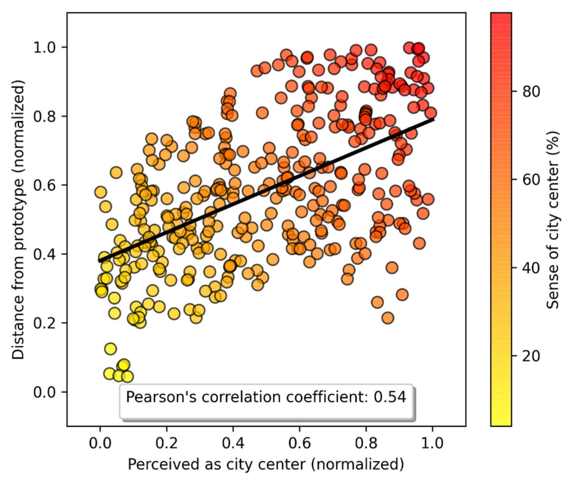
To assess the validity of the results, the participants were requested to confirm whether they perceived the designated neighbourhoods as city centres. The correlation coefficient was then computed to measure the relationship between the calculated values and the participants’ perceptions. Pearson’s correlation coefficient (0.74) and Spearman’s rank correlation coefficient (0.8) showed a strong correlation between the suggested formalization and the expectations of the participants. Therefore, the representation aligns with the participants’ perceptions, validating the proposed approach. In addition, a correlation analysis was applied to all neighbourhood instances to capture the consistency of perceptions and the computed representations. Figure 5 depicts a scatterplot showcasing participants’ average ratings for neighbourhoods plotted against the inverse distances from the prototypical city centres (i.e., the centres of identified polytopes). In this case, the correlation coefficient stands at approximately 0.54.
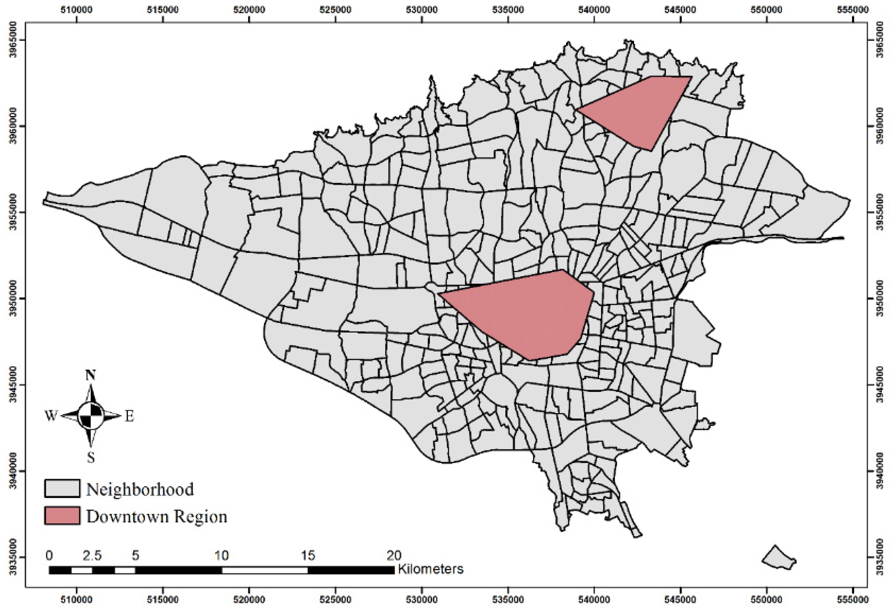
Figure 6 depicts the identified polytope projected onto geographical space. The identified polytope, as shown in the map, is made up of two separate zones. The noteworthy outcome is that one of the indicated regions is not geographically located in the city centre, but the participants perceive it as such.
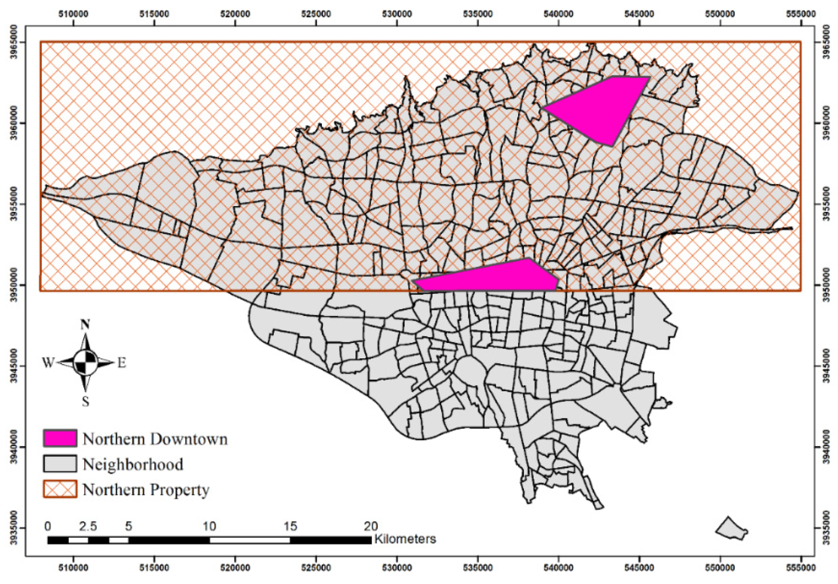
To check for a city centre in northern Tehran, it was necessary to intersect the northern property with the city-centre concept in Tehran. If the intersection produces a distinct polytope, a new concept called the northern city centre is established; otherwise, the outcome is empty. The northern property is considered as areas with latitudes higher than the average latitude of Tehran. The authors performed the intersection operation within the conceptual space and then projected the outcomes onto the spatial domain. Table 6 shows the H- and V-representation of the northern property.
In order to perform the intersection operation, it is necessary to use linear programming to concatenate inequalities from both the city-centre concept and the northern property. The problem is expressed in matrix form as:
Figure 7 shows the results of the intersection operation. Bensolve Tools [58] in Matlab (version R2015) was used to compute the linear programming needed to concatenate the inequalities.
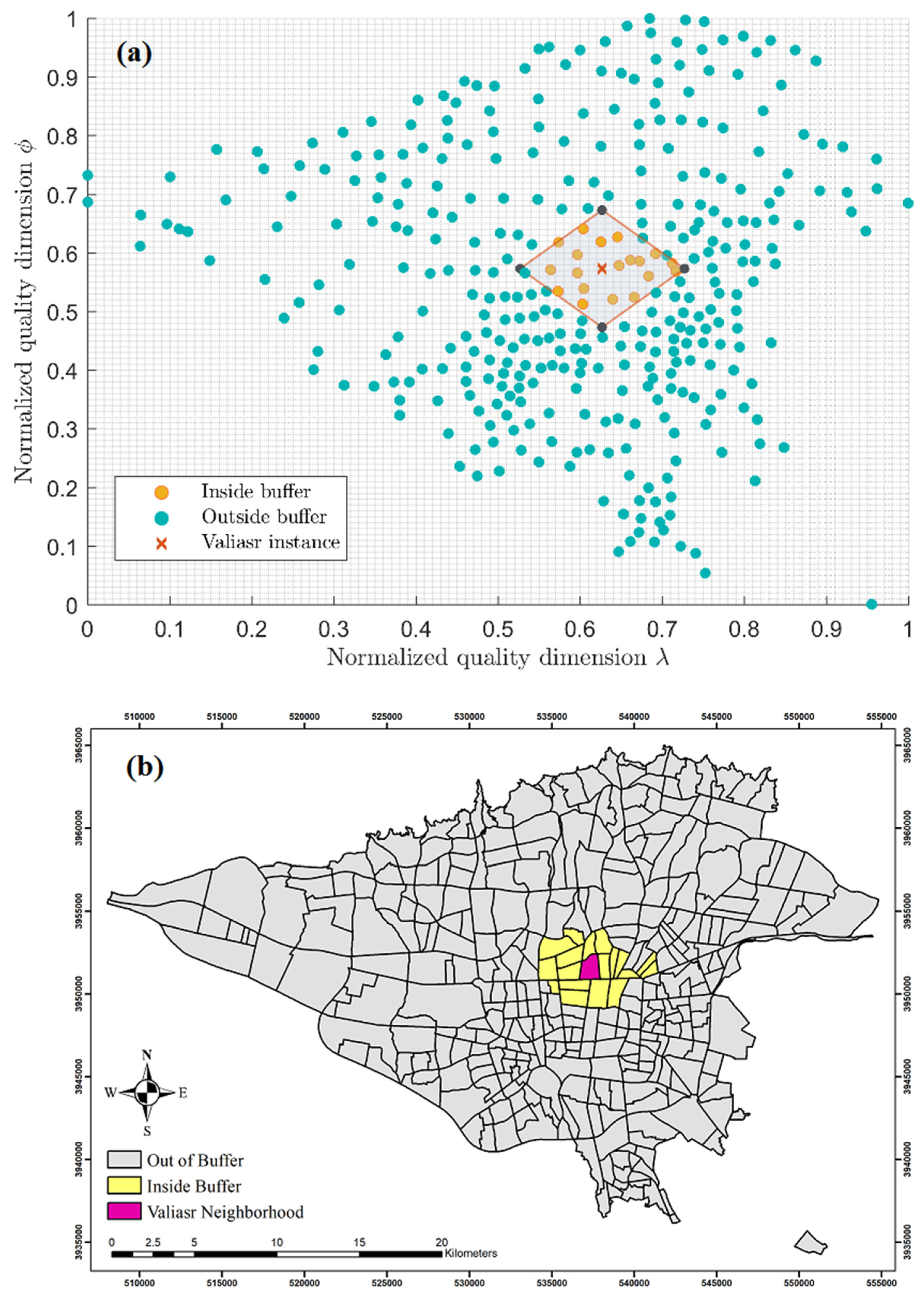
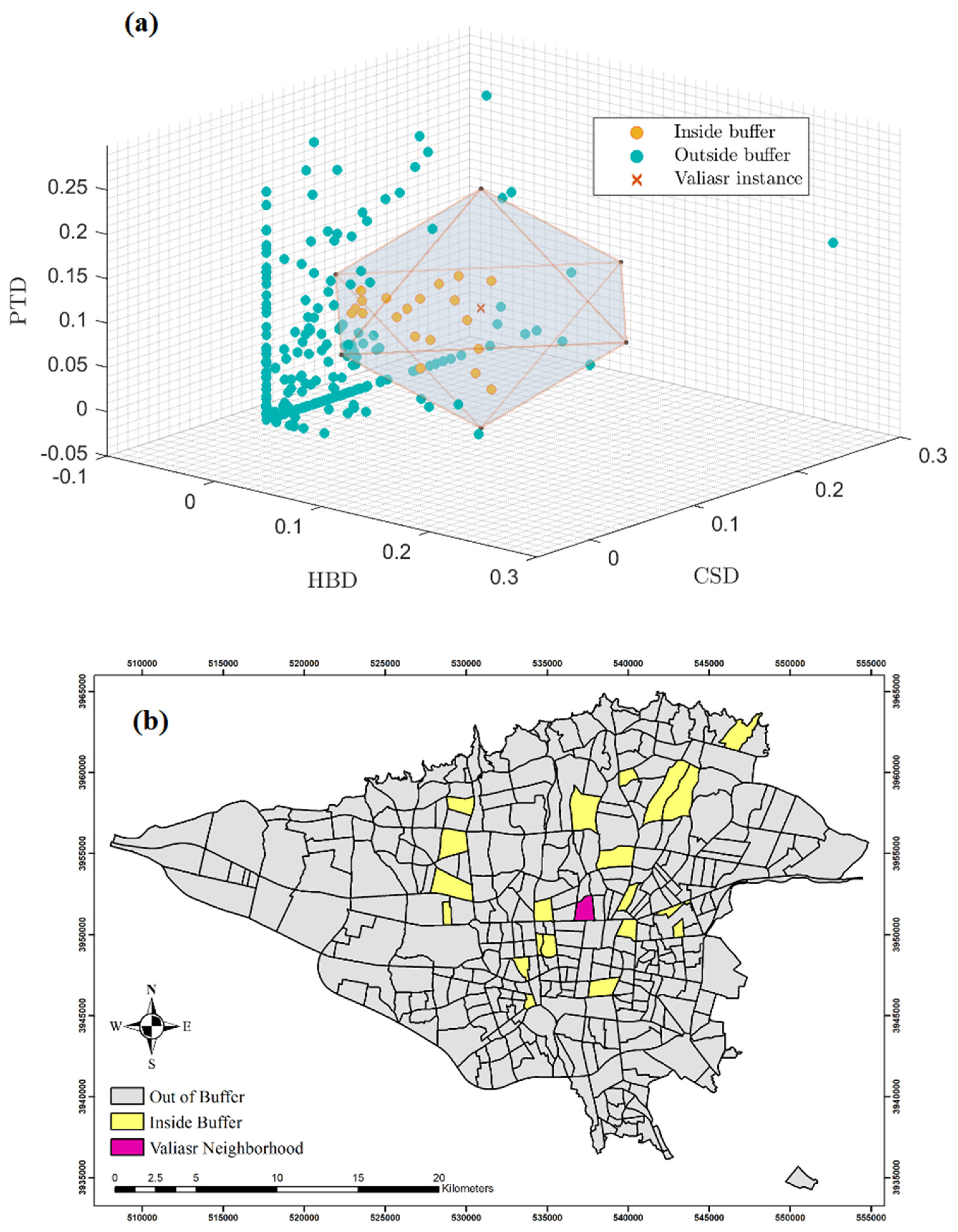
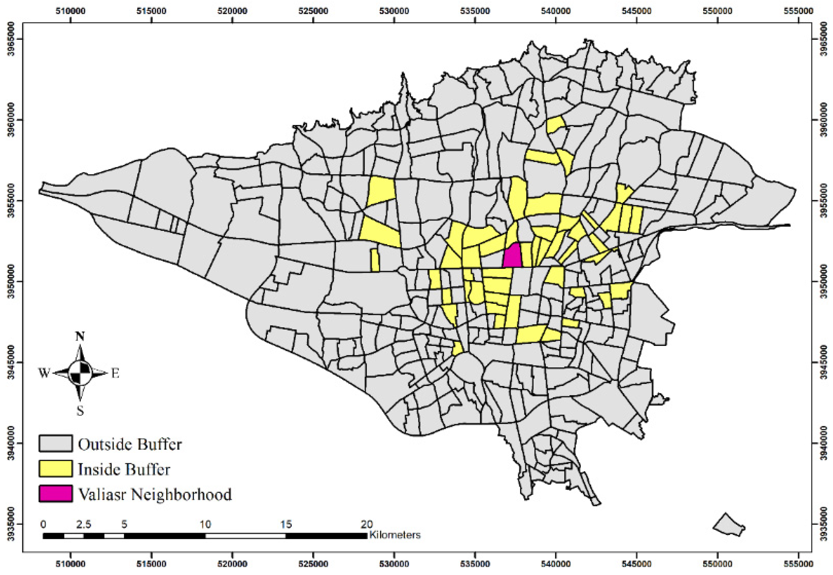
In Figure 8, Figure 9 and Figure 10, three different buffer zones corresponding to the proposed buffers in Section 2.4.6 (e.g., spatial, semantic, and place-based buffers) are shown. In these examples, buffer analyses were applied to Valiasr, a central neighbourhood of Tehran.
Figure 8a shows the proposed spatial buffer in the spatial domain. This buffer is akin to the buffers employed in GIS, which designate areas spatially near the specified entity. However, there are two differences between them. The first difference is their shape, resulting from employing two different metrics. While the commonly used spatial buffer in GIS gauges proximity by encircling the feature with a circle, city-block metric buffers, on the other hand, assume the shape of a sum-norm ball within the buffer zone [59]. Moreover, the distances within the entire conceptual space are not physical but semantic in nature. It is important to note that the conceptual space in question is normalised. Consequently, expressing proximity criteria in percentages would be a more fitting approach. The spatial proximity is equivalent to the spatial buffer. It is considered a range of [0%, 100%], where 0% proximity corresponds to places that are at least 0% (since it is a buffer, it must encompass values greater than zero) similar to a specified place. This encompasses the entire space and includes all existing places. Conversely, when spatial proximity reaches 100%, the result corresponds to the original place under examination, as it is the sole entity that demonstrates complete similarity with itself. Figure 8a represents the outcome of identifying neighbourhoods that are spatially (physically) close to the marked neighbourhood by at least 90%. Figure 8b illustrates the projection of these results onto the geographical space.
In Figure 9a, the placement of the buffer polytope is illustrated within the semantic domain, encompassing historical, commercial, and accessibility dimensions. The buffer zone functions as a query, aiming to identify neighbourhoods with a minimum of 92% similarity to the marked neighbourhood in terms of historical, commercial, and accessibility characteristics. This buffer zone serves as a means to calculate semantic similarity, capturing neighbourhoods that share substantial semantic similarities with the desired one. Figure 9b displays the projected outcomes of the semantic buffer on the map, computed using Equation (3). The yellow neighbourhoods on the map represent points situated within the buffer polytope.
Figure 10 displays the simultaneous consideration of all dimensions, including the two geographical coordinates and the three semantic qualities. This integrated approach, here called a place-based buffer, combines the spatial domain with semantic information derived from other domains. The primary goal is to identify neighbourhoods spatially close to the Valiasr neighbourhood that exhibit similar semantic characteristics. By merging the spatial and semantic domains, this approach offers a comprehensive framework for identifying and analysing neighbourhoods based on their spatial and semantic attributes. To achieve this, the generation of the Voronoi diagram is used based on the instances within the conceptual space. The result of this operation consists of instances whose Voronoi cells are topologically connected to the Valiasr neighbourhood. By utilizing this approach, the place-based buffer is calculated by seamlessly integrating the semantic characteristics of instances with their spatial coordinates. Notably, this integration was accomplished without explicitly relying on physical distance measurements, providing a more comprehensive understanding of the spatial and semantic relationships between instances and the Valiasr neighbourhood.
4. Discussion
This study investigates the potential of conceptual spaces to analyse places in a GIS. A formalisation of conceptual spaces using convex polytopes was used, and this method was applied to the concept of the city centre in Tehran, Iran. The findings demonstrate that the proposed framework can explain place-based understanding in GIS. The proposed approach is an extension of the spatial perspective, encompassing place-based analytical capabilities and incorporating spatial analyses. The proposed formalisation employed in the study utilised convex polytopes, leading to linear geometrical structures within the conceptual spaces. As a consequence, certain peculiarities arose that need further examination. For instance, the buffers generated by the proposed method resulted in areas with straight edges, in contrast to the curved buffers commonly employed in GIS. In some cases, straight edges may be suitable, especially when the goal is to create a simplified representation for quick analysis or visualisation. However, this trade-off results in a loss of detailed accuracy. Curved buffers are commonly favoured in applications that need a precise representation of spatial relationships, such as ecological studies, urban planning, or infrastructure design. This preference originates from the curved buffers’ superior capability to capture the landscape’s context.
Several studies have investigated places using conceptual spaces, but they differ in their approach by constructing the conceptual space based on data-driven methods. For instance, Abbasi and Alesheikh [60] used natural language processing (NLP) methods to construct a conceptual embedding space of place-based textual resources. Their method was put into practice in a recommender system, resulting in an offering of analytical capabilities for places, in terms of similarity computations. Instead of using convex regions to represent concepts, their method used vector computations. Derrac and Schockaert [61] induced a conceptual space from text documents and identified salient directions in the space which corresponded to interpretable relative properties. They showed how commonsense reasoning can exploit these relations, which can outperform standard approaches and provide intuitive explanations of classification decisions. They applied their method to a dataset of places and looked for relationships between place types. The aforementioned research both infer a conceptual space to explain places; the approach of the authors of this paper diverges substantially from theirs in some key ways. The authors follow a knowledge-driven strategy for constructing the conceptual space. This method facilitates the identification and measurement of specific qualitative dimensions related to place-based concepts. By explicitly defining these dimensions, illustrating concepts became clearer as they were represented as convex regions within the conceptual space. This approach reveals interconnections between concepts and enables various analytical calculations within geographic information systems.
A notable advantage of the proposed method in this paper is the clear distinction between the spatial domain and other domains. This distinction allows for separate analyses of the spatial and semantic domains. For instance, in this study, the authors conducted buffer analyses independently on both the spatial and semantic domains. It stands in contrast to other techniques discussed, where the data-driven space becomes entangled with multiple domains, making it more challenging to differentiate and analyse each domain separately.
This study has a few limitations. Firstly, the proposed method relies on the availability of prior knowledge about place-based concepts, which is used to construct the conceptual space. Extracting such knowledge necessitates a rigorous method, either from users or other sources. Secondly, the datasets used as proxies for quality dimensions must be sufficiently representative to precisely quantify the variables. As previously stated, the geometric structure in this method is derived from solving linear inequalities. Exploring alternative formalisations of conceptual spaces could enhance the robustness of this approach. Moreover, depending solely on questionnaires to capture the citizens’ mental image of city centres has some limitations. For instance, questionnaires rely on self-reported data, which may be influenced by individual perspectives and might lack in-depth details. Additionally, given that questionnaires provide only a snapshot, mental images are complex cognitive representations developed over time through experience. Therefore, integrating additional qualitative tools could offer more comprehensive insights. Lastly, the proposed method partially addresses the symbol grounding problem, a recognised advantage of employing conceptual spaces. Through the process of decomposing concepts into their constituent quality dimensions and gathering input from participants regarding these dimensions, it endeavours to determine what these dimensions really mean in the real world. This endeavour contributes to the development of a collective comprehension. However, the issue still exists for the proxies used in quality dimensions. For instance, the density of subway stations, as a proxy for accessibility in the representation of this research does not provide a clear guarantee of its suitability.
5. Conclusions
This paper presents a conceptual framework that uses the theory of conceptual spaces. The adopted framework employs linear programming and convex polytopes for operations and to depict place-based concepts. It can be easily integrated with GIS, establishing a convenient connection between geographical and conceptual spaces. The findings indicate that place-based concepts can be portrayed as convex regions within the conceptual space. The capabilities of the framework through the application of spatial, semantic, and place-based buffers are demonstrated. In summary, the adopted framework provides a thorough approach to formalizing and analysing information related to places.
From a practical standpoint, our framework aids planners, geographers, and policymakers to analyse places with consideration for their cultural and social significance, going beyond mere geographical locations. It has the potential to enhance GIS applications in areas like land planning, cultural heritage preservation, and tourism. The innovative approach proposed introduces new tools for the computerised analysis of places. This research forges a connection between practical mapping and the study of places in a novel manner, intertwining the physical representation of places with their conceptual understanding. This study is the first to leverage conceptual spaces for illustrating and comprehending places, demonstrating the utility of conceptual spaces in understanding and analysing spatial environments. In a broader context, this work unveils new possibilities for developing computer models that capture the meaning of places to individuals. This work uniquely integrates GIS, conceptual modelling, and place theory into a novel computational framework for the representation and analysis of place-based concepts. The fusion of concepts from GIS, cognition, and urban theory represents a distinctive contribution with significant potential to advance future research on place. This approach enables new capabilities to bridge geospatial analysis with humanistic perspectives on place within a computational environment.
The depiction of place concepts as convex regions within a joint spatial-semantic space introduces an original method to both GIScience and spatial cognition fields. For example, the implementation of place-based buffers expands GIS analytical capabilities to consider conceptual similarities beyond spatial proximity. As a suggestion for future work, the proposed framework can be extended to explain he temporal dimension, enabling the analysis of spatiotemporal events and predictive tasks related to place transformations over time.
Future research in this field may explore the configuration of conceptual space in a data-driven manner, automating the identification of quality dimensions rather than relying on manual selection. Investigating the place-based counterparts of established spatial concepts, such as place-based correlation, would be an intriguing avenue to pursue. Additionally, given the growing interest in events within conceptual spaces, the application of these methods to place-based research and the consideration of places as functional spaces present intriguing opportunities for further investigation.
Author Contributions
O.R.A. performed the computations and analysis; he drafted the manuscript and designed the figures. A.A.A. and A.L. made contributions to interpreting results and revising the final manuscripts. A.L. confirmed the validation of the study. C.G. contributed to original draft reviewing and editing. All authors have read and agreed to the published version of the manuscript.
Funding
This research received no external funding.
Institutional Review Board Statement
The Human Ethics approval for this research was obtained from Tehran University Ethics Committee (Reference number IR.UT.PSYEDU.0050).
Data Availability Statement
The original contributions presented in the study are included in the article, further inquiries can be directed to the corresponding author.
Conflicts of Interest
The authors declare no conflicts of interest.
References
- Bergmann, L.; O’Sullivan, D. Reimagining GIScience for relational spaces. Can. Geogr./Le Géographe Can. 2018, 62, 7–14. [Google Scholar] [CrossRef] [PubMed]
- Shapiro, L.G.; Haralick, R.M. A general spatial data structure. In Proceedings of the IEEE Conference Pattern Recognition and Image Processing; IEEE: Piscataway, NJ, USA, 1976; pp. 238–249. Available online: http://www.haralick.org/DV/conferences/general_spatial_data_structure1.pdf (accessed on 10 February 2024).
- Shapiro, L.G.; Haralick, R.M. A spatial data structure. 1979. Available online: https://vtechworks.lib.vt.edu/server/api/core/bitstreams/1d0c0b30-fe89-4ec2-b733-09e8eaa6eb8b/content (accessed on 10 February 2024).
- Papadakis, E.; Blaschke, T. Place-based GIS: Functional Space. In Proceedings of the AGILE 2016, Helsinki, Finland, 14–17 June 2016. [Google Scholar]
- Cresswell, T. Place. In International Encyclopedia of Human Geography; Sage: Newcastle upon Tyne, UK, 2009; Volume 8, pp. 169–177. [Google Scholar]
- Saar, M.; Palang, H. The dimensions of place meanings. Living Rev. Landsc. Res. 2009, 3, 5–24. [Google Scholar] [CrossRef]
- Blaschke, T.; Merschdorf, H.; Cabrera-Barona, P.; Gao, S.; Papadakis, E.; Kovacs-Györi, A. Place versus space: From points, lines and polygons in GIS to place-based representations reflecting language and culture. ISPRS Int. J. Geo-Inf. 2018, 7, 452. [Google Scholar] [CrossRef]
- Wagner, D.; Zipf, A.; Westerholt, R. Place in the GIScience community—An indicative and preliminary systematic literature review. In Proceedings of the 2nd International Symposium on Platial Information Science (PLATIAL’19), Coventry, UK, 5–6 September 2019; pp. 13–22. [Google Scholar]
- Egenhofer, M.J.; Herring, J.R. High-level spatial data structures for GIS. Geogr. Inf. Syst. 1991, 1, 227–237. [Google Scholar]
- Tuan, Y.-F. Space and place: Humanistic perspective. In Philosophy in Geography; Springer: Berlin/Heidelberg, Germany, 1979; pp. 387–427. [Google Scholar]
- Goodchild, M.; Longley, P. The future of GIS and spatial analysis. Geogr. Inf. Syst. 1999, 1, 567–580. [Google Scholar]
- Campbell, C.J. Space, place and scale: Human geography and spatial history in past and present. Past Present 2018, 239, 23–45. [Google Scholar] [CrossRef]
- Fouberg, E.H.; Murphy, A.B. Human Geography: People, Place, and Culture; John Wiley & Sons: Hoboken, NJ, USA, 2020. [Google Scholar]
- Johnston, R.J. A question of place: Exploring the practice of human geography. In A Question of Place: Exploring the Practice of Human Geography; Blackwell: Hoboken, NJ, USA, 1991. [Google Scholar]
- Cabrera-Barona, P.F.; Merschdorf, H. A conceptual urban quality space-place framework: Linking geo-information and quality of life. Urban Sci. 2018, 2, 73. [Google Scholar] [CrossRef]
- Garau, C.; Annunziata, A.; Coni, M. A methodological framework for assessing practicability of the urban space: The survey on conditions of practicable environments (SCOPE) procedure applied in the case study of Cagliari (Italy). Sustainability 2018, 10, 4189. [Google Scholar] [CrossRef]
- Annunziata, A.; Garau, C. Understanding kid-friendly urban space for a more inclusive smart city: The case study of Cagliari (Italy). In Computational Science and Its Applications–ICCSA 2018: Proceedings of the 18th International Conference, Melbourne, Australia, 2–5 July 2018; Proceedings, Part III 18; Springer: Berlin/Heidelberg, Germany, 2018; pp. 589–605. [Google Scholar]
- Cresswell, T. Place: Encountering geography as philosophy. Geography 2008, 93, 132–139. [Google Scholar] [CrossRef]
- Westerholt, R.; Mocnik, F.B.; Comber, A. A place for place: Modelling and analysing platial representations. Trans. GIS 2020, 24, 811–818. [Google Scholar] [CrossRef]
- Goodchild, M.F. Citizens as sensors: The world of volunteered geography. GeoJournal 2007, 69, 211–221. [Google Scholar] [CrossRef]
- Tang, V.; Painho, M. Operationalizing places in GIScience: A review. Trans. GIS 2021, 25, 1127–1152. [Google Scholar] [CrossRef]
- Merschdorf, H.; Blaschke, T. Revisiting the role of place in Geographic Information Science. ISPRS Int. J. Geo-Inf. 2018, 7, 364. [Google Scholar] [CrossRef]
- Abbasi, O.R.; Alesheikh, A.A.; Razavi-Termeh, S.V. Get Spatial from Non-Spatial Information: Inferring Spatial Information from Textual Descriptions by Conceptual Spaces. Mathematics 2023, 11, 4917. [Google Scholar] [CrossRef]
- Papadakis, E.; Resch, B.; Blaschke, T. Composition of place: Towards a compositional view of functional space. Cartogr. Geogr. Inf. Sci. 2020, 47, 28–45. [Google Scholar] [CrossRef]
- Cho, S.; Yuan, M. Placial analysis of events: A case study on criminological places. Cartogr. Geogr. Inf. Sci. 2019, 46, 547–566. [Google Scholar] [CrossRef]
- Davies, C. Place-based knowledge systems: Human and machine. In Proceedings of the 2nd International Symposium on Platial Information Science (PLATIAL’19), Coventry, UK, 5–6 September 2019; pp. 33–41. [Google Scholar]
- Brown, G.; Raymond, C.M.; Corcoran, J. Mapping and measuring place attachment. Appl. Geogr. 2015, 57, 42–53. [Google Scholar] [CrossRef]
- Maguire, B.; Klinkenberg, B. Visualization of place attachment. Appl. Geogr. 2018, 99, 77–88. [Google Scholar] [CrossRef]
- Diener, A.C.; Hagen, J. Geographies of place attachment: A place-based model of materiality, performance, and narration. Geogr. Rev. 2022, 112, 171–186. [Google Scholar] [CrossRef]
- Management and Planning Organization (PMO). Population Statistics. 2023. Available online: https://amar.thmporg.ir/main-topic/99264-population-and-labor/population (accessed on 11 March 2024).
- Pilehvar, A.A. Spatial-geographical analysis of urbanization in Iran. Humanit. Soc. Sci. Commun. 2021, 8, 63. [Google Scholar] [CrossRef]
- Rabiei-Dastjerdi, H.; Kazemi, M. Tehran: Old and emerging spatial divides. In Urban Change in Iran: Stories of Rooted Histories and Ever-Accelerating Developments; Springer: Berlin/Heidelberg, Germany, 2016; pp. 171–186. [Google Scholar]
- Taravat, A.; Rajaei, M.; Emadodin, I. Urbanization dynamics of Tehran city (1975–2015) using artificial neural networks. J. Maps 2017, 13, 24–30. [Google Scholar] [CrossRef]
- Asadi Peyman, Z.; Tavakolinia, J.; Razavian, M.T.; Ghurchi, M. Assessing the Quality of Tourism destinations in the Center of Tehran Case study: Grand Bazaar (District 12 of Tehran). Urban Tour. 2020, 7, 35–50. [Google Scholar]
- Habibi, R.; De Meulder, B. “Iranian Modernist Middle-Class Housing” The “Narmak-Tehran-1952” and “Kuy-4-Aban-(1000 Dastgah) Tehran-1969”. In Proceedings of the Middle-Class Housing in Perspective. From Post-War Construction to Post-Millennial Urban Landscape, Milan, Italy, 22–23 November 2012. [Google Scholar]
- Shaker Ardekani, R. Tracing musical tastes in Tehran: How urbanism selects its sound. Cogent Soc. Sci. 2016, 2, 1132093. [Google Scholar] [CrossRef]
- Kang, C.; Ma, X.; Tong, D.; Liu, Y. Intra-urban human mobility patterns: An urban morphology perspective. Phys. A Stat. Mech. Its Appl. 2012, 391, 1702–1717. [Google Scholar] [CrossRef]
- Rafiee, N.; Mahesh, T.; Tali, J.A.; Emtehani, M.R. The appropriate approach to renewal the historical center of Shiraz City, Iran. N. Y. Sci. J. 2012, 5, 80–85. [Google Scholar]
- Pourjafar, M.; Amini, M.; Varzaneh, E.H.; Mahdavinejad, M. Role of bazaars as a unifying factor in traditional cities of Iran: The Isfahan bazaar. Front. Archit. Res. 2014, 3, 10–19. [Google Scholar] [CrossRef]
- Farkisch, H.; Ahmadi, V.; Che-Ani, A.I. Evaluation of neighborhood center attributes on resident’s territoriality and sense of belonging a case study in Boshrooyeh, Iran. Habitat Int. 2015, 49, 56–64. [Google Scholar] [CrossRef]
- Kermani, A.A.; Luiten, E. Preservation and transformation of historic urban cores in Iran, the case of Kerman. J. WSEAS Trans. Environ. Dev. 2010, 6, 53–62. [Google Scholar]
- Mirzakhani, A.; Turró, M.; Behzadfar, M. Factors affecting social sustainability in the historical city centres of Iran. J. Urban. Int. Res. Placemaking Urban Sustain. 2023, 16, 498–527. [Google Scholar] [CrossRef]
- Lee, H.; Chung, N.; Nam, Y. Do online information sources really make tourists visit more diverse places?: Based on the social networking analysis. Inf. Process. Manag. 2019, 56, 1376–1390. [Google Scholar] [CrossRef]
- Municipality, T.S. Tehran’s Munipality Geoportal. 2023. Available online: https://map.tehran.ir (accessed on 11 March 2024).
- Logan, J.R. Making a place for space: Spatial thinking in social science. Annu. Rev. Sociol. 2012, 38, 507–524. [Google Scholar] [CrossRef]
- Singh, D.; Singh, B. Investigating the impact of data normalization on classification performance. Appl. Soft Comput. 2020, 97, 105524. [Google Scholar] [CrossRef]
- Crone, S.F.; Lessmann, S.; Stahlbock, R. The impact of preprocessing on data mining: An evaluation of classifier sensitivity in direct marketing. Eur. J. Oper. Res. 2006, 173, 781–800. [Google Scholar] [CrossRef]
- Jia, B.-B.; Zhang, M.-L. Multi-dimensional classification via decomposed label encoding. IEEE Trans. Knowl. Data Eng. 2021, 35, 1844–1856. [Google Scholar] [CrossRef]
- Kunanbayev, K.; Temirbek, I.; Zollanvari, A. Complex encoding. In Proceedings of the 2021 International Joint Conference on Neural Networks (IJCNN), Shenzhen, China, 18–22 July 2021; IEEE: Piscataway, NJ, USA, 2021; pp. 1–6. [Google Scholar]
- Tiwary, H.R. On the hardness of computing intersection, union and minkowski sum of polytopes. Discret. Comput. Geom. 2008, 40, 469–479. [Google Scholar] [CrossRef]
- Bárány, I. A generalization of Carathéodory’s theorem. Discret. Math. 1982, 40, 141–152. [Google Scholar] [CrossRef]
- Grünbaum, B. Convex Polytopes; Springer Science & Business Media: Berlin/Heidelberg, Germany, 2013. [Google Scholar]
- Aggarwal, C.C.; Hinneburg, A.; Keim, D.A. On the Surprising Behavior of Distance Metrics in High Dimensional Space; Springer: Berlin/Heidelberg, Germany, 2001; pp. 420–434. [Google Scholar]
- Johannesson, M. The Problem of Combining Integral and Separable Dimensions; Lund University: Lund, Sweden, 2001. [Google Scholar]
- Ziegler, G.M. Lectures on Polytopes; Springer Science & Business Media: Berlin/Heidelberg, Germany, 2012. [Google Scholar]
- Aurenhammer, F. Voronoi diagrams—A survey of a fundamental geometric data structure. ACM Comput. Surv. (CSUR) 1991, 23, 345–405. [Google Scholar] [CrossRef]
- Browning, M.; Lee, K. Within what distance does “greenness” best predict physical health? A systematic review of articles with GIS buffer analyses across the lifespan. Int. J. Environ. Res. Public Health 2017, 14, 675. [Google Scholar] [CrossRef] [PubMed]
- Löhne, A.; Weißing, B. The vector linear program solver Bensolve–notes on theoretical background. Eur. J. Oper. Res. 2017, 260, 807–813. [Google Scholar] [CrossRef]
- Grötschel, M.; Lovász, L.; Schrijver, A. Geometric Algorithms and Combinatorial Optimization; Springer Science & Business Media: Berlin/Heidelberg, Germany, 2012. [Google Scholar]
- Abbasi, O.R.; Alesheikh, A.A. A Place Recommendation Approach Using Word Embeddings in Conceptual Spaces. IEEE Access 2023, 11, 11871–11879. [Google Scholar] [CrossRef]
- Derrac, J.; Schockaert, S. Inducing semantic relations from conceptual spaces: A data-driven approach to plausible reasoning. Artif. Intell. 2015, 228, 66–94. [Google Scholar] [CrossRef]
Figure 1.
The location of Tehran Province in Iran, and the location of Tehran city in the province.

Figure 2.
The workflow of the study.

Figure 3.
A schematic view of the proposed buffers in conceptual spaces.

Figure 4.
A schematic view of the intersection of two concepts in conceptual spaces.

Figure 5.
The average ratings of perception as city centre against the inverse distance from prototypical city centre.
Figure 5.
The average ratings of perception as city centre against the inverse distance from prototypical city centre.

Figure 6.
The projection of the city-centre polytopes on the geographical space.

Figure 7.
The intersection of the city-centre concept and the northern property, projected on the geographical space.
Figure 7.
The intersection of the city-centre concept and the northern property, projected on the geographical space.

Figure 8.
(a) The polytope representation of the spatial buffer on Valiasr neighbourhood in the spatial domain; (b) the projection of the spatial buffer results on the geographical space.
Figure 8.
(a) The polytope representation of the spatial buffer on Valiasr neighbourhood in the spatial domain; (b) the projection of the spatial buffer results on the geographical space.

Figure 9.
(a) The polytope representation of the semantic buffer on Valiasr neighbourhood; (b) the projection of the semantic buffer results on the geographical space.
Figure 9.
(a) The polytope representation of the semantic buffer on Valiasr neighbourhood; (b) the projection of the semantic buffer results on the geographical space.

Figure 10.
The representation of place-based buffer on Valiasr neighbourhood in the geographical space.
Figure 10.
The representation of place-based buffer on Valiasr neighbourhood in the geographical space.


Table 1.
The term and definitions used throughout this paper.
| Term | Definition |
|---|---|
| Space | The medium formed by a well-defined geographical coordinate system in which GIS software and methods represent features [9] |
| Place | The intertwining of a physical location with the meanings, feelings, emotions, and other human experiences connected to that location [10] |
| Spatial analysis | The set of methods applied to the geographical coordinates of features in the space [11] |
| Place-based analysis | The set of methods applied to both the geographical coordinates and other dimensions that make place (e.g., meaning, cognition, emotion, etc.) |
| Neighbourhood | An example of place—parts of space that gain meaning and value through residents’ place attachment and daily activities. |
| City centre | An example of place—neighbourhoods that have unique characteristics and make citizens perceive them as the heart of the city. The characteristics differ depending on the culture, environment, etc. |
Table 2.
The reviewed papers and the characteristics of city centre in Iranian cities.
| Article | Year | Identified Characteristics of Iranian City Centres |
|---|---|---|
| Rafiee, et al. [38] | 2012 | Stresses the historical aspects of city centres |
| Pourjafar, et al. [39] | 2014 | Focuses on bazaars (historical shopping centres) as a prominent component of city centres |
| Farkisch, et al. [40] | 2015 | Architectural style; arrangement of houses; accessibility; heritage buildings; place functionality |
| Kermani and Luiten [41] | 2010 | Population density; location; historical monuments |
| Mirzakhani, et al. [42] | 2023 | Stresses the historical aspects of city centres |
Table 3.
The H-representation and V-representation of the city centre polytope.
| Polytope | H-Representation | V-Representation |
|---|---|---|
Table 4.
The details of some elements defined in the conceptual space and their corresponding definitions.
Table 4.
The details of some elements defined in the conceptual space and their corresponding definitions.
| Element | Type | Representation | |
|---|---|---|---|
| City centre | Concept | ||
| Northern | Property | ||
| Valiasr neighbourhood | Instance |
Table 5.
The result of applying query “where are the city-centre-like neighbourhoods in Tehran?” in terms of place names and their associated ratings based on the proposed representation and citizens’ ratings (only 10 neighbourhoods listed).
Table 5.
The result of applying query “where are the city-centre-like neighbourhoods in Tehran?” in terms of place names and their associated ratings based on the proposed representation and citizens’ ratings (only 10 neighbourhoods listed).
| Place Names | Degree of Being a City Centre (Based on Normalised Distance) | Citizens’ Opinions |
|---|---|---|
| City centre Prototype () | 1 | - |
| Bazaar | 0.94 | 0.90 |
| Enqelab | 0.90 | 0.92 |
| Monirieh | 0.89 | 0.73 |
| Jomhuri | 0.82 | 0.85 |
| Rah Ahan | 0.81 | 0.65 |
| Emam Khomeini | 0.77 | 0.82 |
| Pamenar | 0.76 | 0.79 |
| Tajrish | 0.71 | 0.67 |
| Qeitarieh | 0.67 | 0.31 |
| Ostad Moein | 0.60 | 0.55 |
| Pearson Correlation Coefficient | 0.7471 | |
| Spearman’s Rank Correlation Coefficient | 0.8061 | |
Table 6.
The H-representation and V-representation of the northern polytope.
| Polytope | H-Representation | V-Representation |
|---|---|---|
Disclaimer/Publisher’s Note: The statements, opinions and data contained in all publications are solely those of the individual author(s) and contributor(s) and not of MDPI and/or the editor(s). MDPI and/or the editor(s) disclaim responsibility for any injury to people or property resulting from any ideas, methods, instructions or products referred to in the content. |
© 2024 by the authors. Licensee MDPI, Basel, Switzerland. This article is an open access article distributed under the terms and conditions of the Creative Commons Attribution (CC BY) license (https://creativecommons.org/licenses/by/4.0/).
Share and Cite
MDPI and ACS Style
Abbasi, O.R.; Alesheikh, A.A.; Lotfata, A.; Garau, C. Bridging Geospatial and Semantic Worlds: Enhancing Analysis of Place-Based Concepts in GIS. Land 2024, 13, 377. https://doi.org/10.3390/land13030377
AMA Style
Abbasi OR, Alesheikh AA, Lotfata A, Garau C. Bridging Geospatial and Semantic Worlds: Enhancing Analysis of Place-Based Concepts in GIS. Land. 2024; 13(3):377. https://doi.org/10.3390/land13030377
Chicago/Turabian StyleAbbasi, Omid Reza, Ali Asghar Alesheikh, Aynaz Lotfata, and Chiara Garau. 2024. "Bridging Geospatial and Semantic Worlds: Enhancing Analysis of Place-Based Concepts in GIS" Land 13, no. 3: 377. https://doi.org/10.3390/land13030377
Note that from the first issue of 2016, this journal uses article numbers instead of page numbers. See further details here.