


Introduction
The study of traditional villages in West Africa presents an unexplored area within ethnoarchaeological and ethnobotanical research. Our project, which launched in 2018, examines the effects of settlement abandonment within the Niokolo-Koba National Park in south-eastern Senegal. The park was founded in 1954 as a means to conserve the area's high biodiversity. It was later expanded in 1969, and now encompasses 9130km2. The establishment of the park led to the abandonment of 18 villages (Figure 1), which were relocated outside of the conservation area (Charest Reference Charest1969; Ministere de l'Environnement 2000). The population of these villages either established entirely new settlements around the park or were integrated into pre-existing, traditional villages. These displaced peoples and their settlements in both the original and new locations present valuable opportunities to study the organisation of such villages and traits associated with the ethnic group, as well as social hierarchy, religious-ritual practices and subsistence strategies. The main aims of the project are to address the transformation of agricultural villages through the documentation of the current condition of both the abandoned and populated settlements around the park and to interpret this information using testimony from residents, alongside the analysis of cultural and environmental features.

Figure 1. Map of Niokolo-Koba National Park in Senegal, showing the location of the surveyed villages (credit: J. Bumerl).
Abandoned and populated villages in their landscape context
To understand the socio-cultural and environmental effects of abandonment, we combined remote sensing, ethnographic observations, and soil and vegetation analyses in order to compare abandoned and populated villages, along with unaltered areas near to these settlements. We then used the results of these analyses to evaluate the effects of past and present human activity. We also conducted interviews to document traditions, agricultural practices, and the establishment and organisation of the villages under study.
Using remote sensing and field surveys, we identified two main types of spatial organisation within populated settlements: a) newly established villages with a linear arrangement, mostly along the main regional road (e.g. Niéméniké; Figure 2A); and b) traditional villages that have been occupied over extended periods, which have a centralised arrangement. Linear villages, established during the twentieth century, are dependent on recent road networks, while traditional villages are often autarkic, being further from roads and established via several waves of migration dating back to as early as the thirteenth century AD (Camara Reference Camara2015). Traditional villages typically have a central public space dominated by one or more large, old trees; for example, at Badon (Figure 2B), where an African baobab (Adansonia digitata) and a kapok tree (Ceiba pentandra) stand out. These long-lived woody species serve as reference points and play an important role in preserving the location of Sub-Saharan settlements (Blench Reference Blench and Cappers2007).

Figure 2. Satellite images and digitised plans (insets) showing the different layout of villages: A) newly established village of Niéméniké, with linear arrangement; B) traditional, long-time inhabited village of Badon, with centralised arrangement (credit: J. Bumerl).
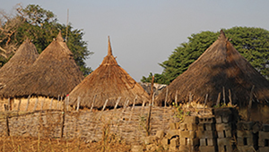
The limited availability of local building materials results in little architectural variation within these agricultural settlements (Figure 3A). Most homesteads are kraals, consisting of fenced plots that contain round huts built from local trees, grasses and clay (McIntosh Reference McIntosh1974; Pelmoine & Mayor Reference Pelmoine and Mayor2020) (Figure 3B). Inside the kraals, small farm animals are bred and protected from predators, and villages are surrounded by fields and orchards where cattle can graze. Many settlements also have sacred spaces to practice animistic rituals.

Figure 3. A) Typical round huts inside the kraal; B) hut wall showing the wattle-and-daub structure (credit: T. Majerovičová).
Since 2018, several abandoned villages—already overgrown by vegetation—have been surveyed and the remains of homesteads, structures and objects related to past human activity have been documented, including walls, wooden posts, benches, pottery, and other features of daily life. A frequent feature was an arrangement of three closely grouped stones, used as fireplaces, on which cooking-pots and bowls could be placed (Figure 4A–C). Several vessels were found ‘half-buried’ upside-down—a form of ritual practice, according to the locals (Figure 4D).

Figure 4. Evidence of material culture in the abandoned villages: A) remains of wooden posts; B) remains of benches commonly used for drying fruit or sitting; C) arrangement of three stones commonly used as a cooking space; D) a vessel ritually ‘half-buried’ upside-down (credit: T. Majerovičová).
Comparisons with nearby unsettled areas demonstrate that areas transformed by past human activity differ markedly in terms of soil and vegetation composition. The main types of soils in the region are poorly developed tropical red soils, which can generate hard, ferrolateritic crusts in areas with high iron content. Soil samples collected along transects running across the villages and their surroundings, as well as those from excavated test pits, however, demonstrate compositional differences due to human activity. A trench excavated inside a ruined structure at Niéméniké, for example, contained a 300mm-thick grey-brown cultural layer (Figure 5A–B). Our results thus contribute to the study of African Dark Earths (anthroposols), which have become a focus for recent geoarchaeological research (Frausin et al. Reference Frausin2014).

Figure 5. A) Remnants of human activity in the abandoned village Niéméniké, including a post made from the tree species Prosopis africana (African mesquite) and a vessel ritually ‘half-buried’ upside-down; B) excavated trench and a soil profile with a grey-brown, 300mm-thick cultural layer. An orange-coloured lateritic soil, rich in iron, lies beneath (credit: T. Majerovičová).
Vegetation sampling was conducted in the abandoned villages to identify the main species present, which tend towards shrub- or woodland savannah. This is characterised by the predominance of kosso (Pterocarpus erinaceus), bushwillow (Combretum glutinosum), monkey bread (Piliostigma thonningii), kwandari (Terminalia macroptera), red kapok tree (Bombax costatum), raisinier (Lannea acida) and monkey orange (Strychnos spinosa). The herbaceous layer includes grasses (Poaceae), which are highly flammable when dry; fire is therefore an important anthropogenic factor in shaping the vegetation structure. Abandoned villages are also characterised by the presence of trees planted in the past, such as African baobab, kapok, palmyra palm (Borassus akeassii) or teak (Tectona grandis). The cultural significance of these and other species was assessed through ethnobotanical survey, using questionnaires that determined how the inhabitants of these villages used such plants and depended on the National Park for their livelihoods.
Preliminary dendrochronological analyses have shown that certain species (e.g. teak or African mahogany (Khaya senegalensis)) can be dated precisely in order to provide context to various elements of a settlement's structure (Figure 6). The dendrochronological survey may further contribute to an estimation of the age of trees that have grown inside abandoned structures, thus offering a proxy date for the minimum time of their abandonment (Schweingruber Reference Schweingruber1989).

Figure 6. Dendrological sampling of trees in Niéméniké. The bark of this cored baobab (Adansonia digitata) shows signs of earlier human use (e.g. for the manufacture of ropes). The researcher Idrissa Manka features in the photograph (credit: J. Beneš).
Conclusions
The area under study is currently at risk of a decline in both cultural and biological diversity. A rapid move towards modernised lifeways is being recorded in contemporary village organisation and the subsistence strategies of the local population. Understanding the transformation of traditional knowledge and values in an age of rapid modernisation and globalisation is key to preserving this unique cultural heritage, making the study of such societal change a pressing issue. Our ongoing research provides an extraordinary opportunity to study both societal and environmental transformations of rural areas in Africa, and document rapidly vanishing traditional knowledge that represents a significant component of the cultural identity and natural resources of south-eastern Senegal.
Acknowledgements
We are deeply grateful to the inhabitants and authorities of Niokolo-Koba National Park for their valuable help.
Funding statement
The project is supported by the Faculty of Science and the Grant Agency of the University of South Bohemia (GA JU 131/2019/H) and the Erasmus Plus mobility programme.


