


Introduction
The Doroshivtsi III site is one of a group of Gravettian sites that formed an important settlement centre during the Last Glacial Maximum (LGM), c. 26–19 ka BP. These sites occur in the canyon-type valley of the Middle Dniester River, located between the Podillia and Khotyn Uplands, in the Carpathian foreland (Figure 1). During the LGM, the Palaeolithic people who inhabited the upland areas moved from the interior, which was covered by permafrost and affected by intense periglacial processes, to a narrow, deep (70–110m) canyon (Figures 1 & 2). This valley would have been warmer and sheltered, offering a more favourable environment for human and animal existence than its severe surroundings (Łanczont & Madeyska Reference Łanczont and Madeyska2015; Haesaerts et al. Reference Haesaerts2020).
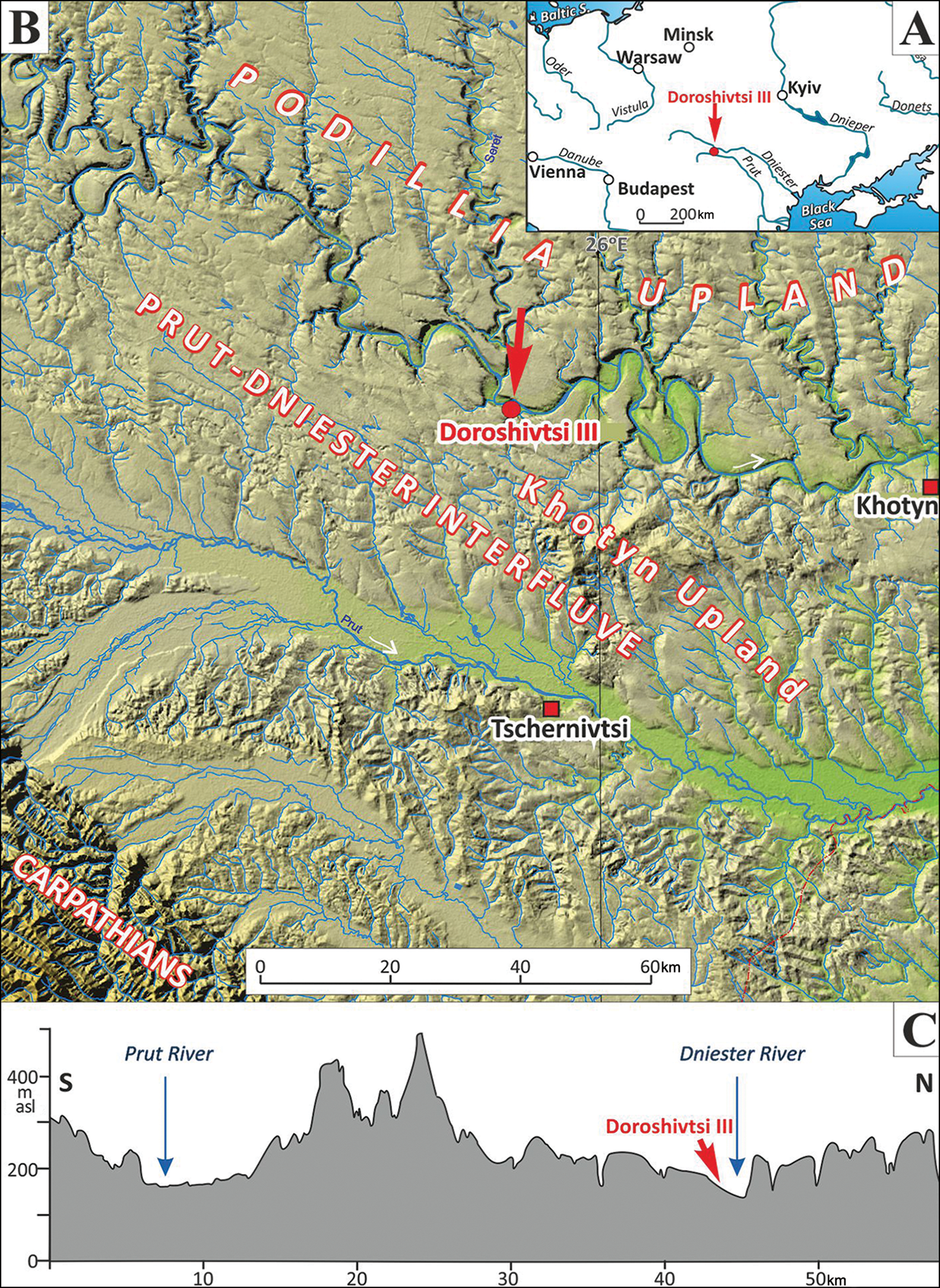
Figure 1. Location of the Doroshivtsi III site in relation to: A) the central part of Europe; B) a digital elevation model (DEM) of the Middle Dniester and Prut Rivers interfluve; and C) the cross-section of the area between the Dniester and Prut River valleys (figure by M. Łanczont and P. Mroczek; relief model by Ł. Chabudziński and B. Hołub).
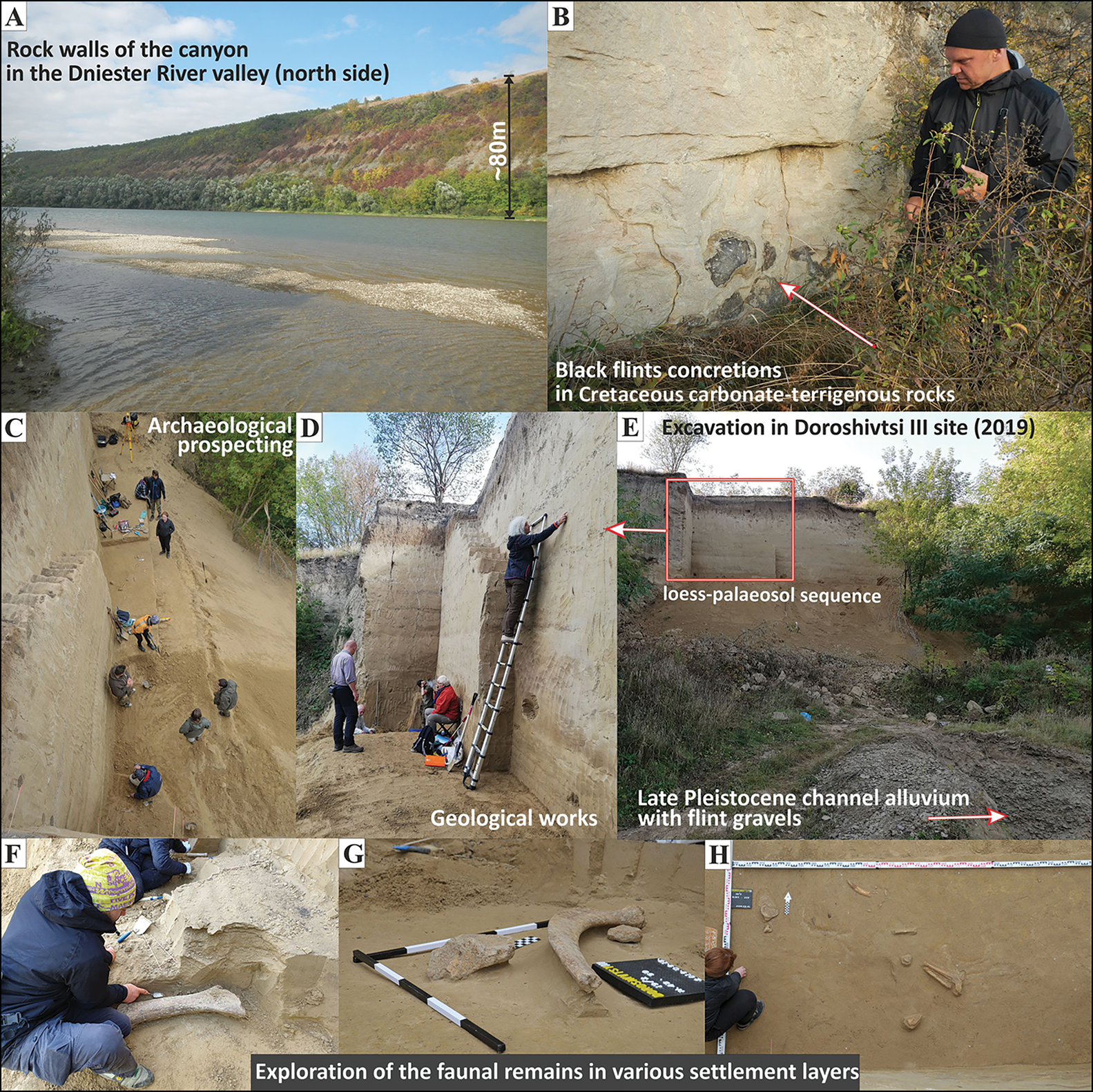
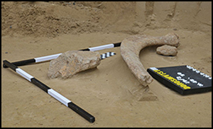
Figure 2. Photographic documentation of the 2019 excavation: A) rock walls of the canyon in the Dniester River valley (north side); B) black flint concretions in Cretaceous carbonate-terrigenous rocks; C) archaeological prospecting; D) geological works; E) excavation at the Doroshivtsi III site; F–H) exploration of the faunal remains in various settlement layers (photographs by D. Bobak, M. Połtowicz-Bobak and M. Łanczont).
Location and geology
The Dniester River Valley is formed of Devonian and Cretaceous rocks covered by Miocene limestone, gypsum and anhydrite (Vashchenko et al. Reference Vashchenko2010). The described section of the valley narrows at both ends. In the middle course of the river, on its south side, is a large Palaeolithic settlement associated with the Late Pleistocene loess terrace. The flint concretions found in situ within the Cretaceous rocks and flint gravel transported by the Dniester River were probably the main source of raw material for the Palaeolithic tool industry (Figure 2A–B).
History of previous study and scope of new research
The site was first excavated between 2006 and 2010 by two teams of scientists. Based on their findings, which comprised the litho- and pedological variability of sediments, pollen analysis, and radiocarbon and OSL dating, it was possible to determine the timing and environment of the depositional and post-depositional processes. Seven archaeological layers were found within deposits indicative of a cold, humid climate. The archaeological finds included an assemblage of lithic artefacts, together with animal bones (including mammoth, horse and reindeer). Moreover, bone artefacts (including decorated examples) and structures were also preserved (Kulakovska et al. Reference Kulakovska2015; Haesaerts et al. Reference Haesaerts2020).
Our investigations in 2019 were carried out in another part of the site, bordering the former trench to the south-west and covering an area of 22.4m2. This first season of fieldwork and multi-tool laboratory analysis (i.e. geological, chronostratigraphic, archaeological and palaeontological) has opened a new stage in exploration of the site.
Geological studies and optically stimulated luminescence (OSL) dating
The geological fieldwork included a detailed description, sampling for physico-chemical analysis and OSL dating of the upper segment of the Doroshivtsi III section, down to approximately 8.3m (Figure 3). The calcareous sequence (5–55 per cent CaCO3) is composed of layered aeolian slope or solifluction deposits, which mostly consist of silt with variable sand and clay fractions, enriched in an admixture of fine debris of local carbonate rocks. A total of seven (I–VII) litho-pedological stratigraphic units (SU) were distinguished (subdivided into smaller sub-units). They are discontinuous and of variable thickness, and mutually shear and overlap each other, although their boundaries are usually sharp. Small solifluction lobes, enriched in debris, play an important role as lithostratigraphic markers. Numerous thin soil horizons from the initial pedosediment are present, ranging from those that are probably not stratigraphically important (i.e. locally significant) to well-developed tundra-gley forms. The variability in the spatial sediment makes it quite difficult to draw comparisons between the sequences explored at Doroshivtsi in 2006–2010 and those studied in 2019.

Figure 3. The Doroshivtsi III section in the Dniester River canyon (A) and litho-pedostratigraphy of the section (B) (figure by M. Łanczont and P. Mroczek).
Fifteen OSL dates were obtained and are in the range of 20–34 ka, providing grounds to assume that most of the sequence may be correlated with MIS 2.
Palaeontology
A total of 283 faunal elements were found, corresponding to at least 30 individuals (minimum number of individuals (MNI)). These include the remains of reindeer, horse, mammoth, wolf and vulpine, and crow. Some evidence for fracturing through impact was identified on the long bones of horses and reindeer, which we have linked to marrow removal. These species are the same as those excavated in 2006–2010, with the addition of wolf and crow. The density of the remains is lower than that observed in the previously excavated sector (Kulakovska et al. Reference Kulakovska2015), possibly because it was in a different sector of the camp. In addition, mammoth remains are more heavily represented than expected, with in situ individuals present whose status needs to be better understood.
Small mammals
Rare remains of small mammals were found in stratigraphic units V–VII, mainly European narrow-headed vole (Lasiopodomys anglicus) and steppe pika (Ochotona pusilla), supplemented by tundra vole (Alexandromys oeconomus), Arctic lemming (Dicrostonyx torquatus) and birch mouse (Sicista sp.) in unit VII. The whole assemblage reflects a steppe-tundra community typical of the LGM (Nadachowski Reference Nadachowski1989). This animal community lived in a largely treeless and/or bushy environment with a mosaic of grassy vegetation, in relatively cool and wet climate conditions.
Archaeology
The excavations in 2019 allowed the identification of 10 layers, with artefacts at depths of 6–10m (in SU V-4 and below), from which 67 lithics were recovered, including 62 flint and five stone artefacts (Figure 4). The first nine layers are associated with the Gravettian; the cultural attribution of the tenth layer is currently impossible to determine (Figures 3B and 5). The 2019 layers were distinguished based on vertical distribution of the artefacts (Figure 5) and an attempt to correlate with the 2006–2010 levels. Even considering the small scale of excavated space, they were very sparse in terms of artefacts: only 25 were observed in the richest layer (Layer 2), with between two and 15 discovered in the others. In contrast, over 23 000 artefacts were found in the most abundant layer (Layer 6) in the 2006–2010 study (Kulakovska et al. Reference Kulakovska2015). Surprisingly, all the layers excavated in 2019 also demonstrate an almost complete lack of retouched tools and chips. Most of the inventory is composed of debitage and finished blades. The lithic industry uses local raw material and most of the finds were fragmented. This fact, combined with their position in the sediment (oblique and vertical), may suggest redeposition, which is supported by stratigraphic data.

Figure 4. Lithics from Doroshivtsi III: 1) pre-core; 2) burin; 3) end-scraper; 4) blade; 5) scraper; 6) bladelet; 7) core (scale in cm) (illustrations by O. Kononenko).

Figure 5. Planigraphy of the Doroshivtsi III site (figure by D. Bobak).
An important discovery of the 2019 excavations was the identification of the lowest settlement horizon, so far evidenced by only a single core. This artefact was found some 2m beneath the lowest Gravettian horizon, in a silty sand layer. Its age was estimated to be 29.3 ka via OSL dating, and pre-dates the Gravettian.
Settlement chronology
Most of the radiocarbon dates (Reimer et al. Reference Reimer2020) obtained from the charcoal indicate that the entire period of human settlement at Doroshivtsi occurred during the maximum phase of the LGM. The results of Bayesian modelling (Bronk Ramsey Reference Bronk Ramsey2009) suggest a relatively short period of occupancy at the site (Figure 6). Basically, all layers with artefacts should be associated with the Greenland Stadial 3 (GS-3, c. 27.5–24.3 ka BP), which corresponds to Heinrich Event 2 (HE-2, c. 26.5–24.3 ka BP). Only the lowest (unnumbered) layer with its single artefact, discovered at 10.1m (i.e. approximately 1.5m below unit VII), seems to be older than modelled.

Figure 6. Chronology of the site. Chart prepared with OxCal 4.4.4 (Bronk Ramsey Reference Bronk Ramsey2009, Reference Bronk Ramsey2021), using atmospheric data from Reimer et al. (Reference Reimer2020) (figure by D. Bobak and M. Łanczont).
Discussion and final remarks
The results indicate significant differences between the areas studied previously in 2006–2010 and those excavated in 2019. This applies to both the natural and archaeological data. Geological and stratigraphic observations do not fully map onto the earlier published data, thus precluding the precise correlation of layers. It is also difficult to compare and align settlement layers documented in the two studies. It can, however, be noted that the settlement layers are associated with a series of soil/vegetation sub-horizons within stratigraphic units V–VII. The differences in the structure and frequency of both flint artefacts and animal bones observed between the 2006–2010 and 2019 excavations may hint at the functional diversity of the camp, but this variation could also stem from post-depositional processes and the relocation of materials. Nevertheless, these findings indicate that the site is much more complex—both archaeologically and geologically—than previously (Kulakovska Reference Kulakovska2015; Haesaerts Reference Haesaerts2020) suggested. Further research should aim to verify the number and distribution of settlement layers and their date and characteristics, and also to determine whether these layers are in situ. The palaeogeographical research will focus on the reconstruction of the natural environment in the immediate vicinity of the site—an area whose morphology fostered particularly favourable conditions for settlement.
Funding statement
This research was funded by the National Science Centre Poland (project 2018/31/B/HS3/03125, Environment and Culture of the Gravettian and Epigravettian Gatherers and Hunters in the Middle Dniester Valley).


