
A Performance Evaluation of Potential Intensity over the Tropical Cyclone Passage to South Korea Simulated by CMIP5 and CMIP6 Models

 , , ,
, , ,  , ,
, ,
Abstract
:1. Introduction
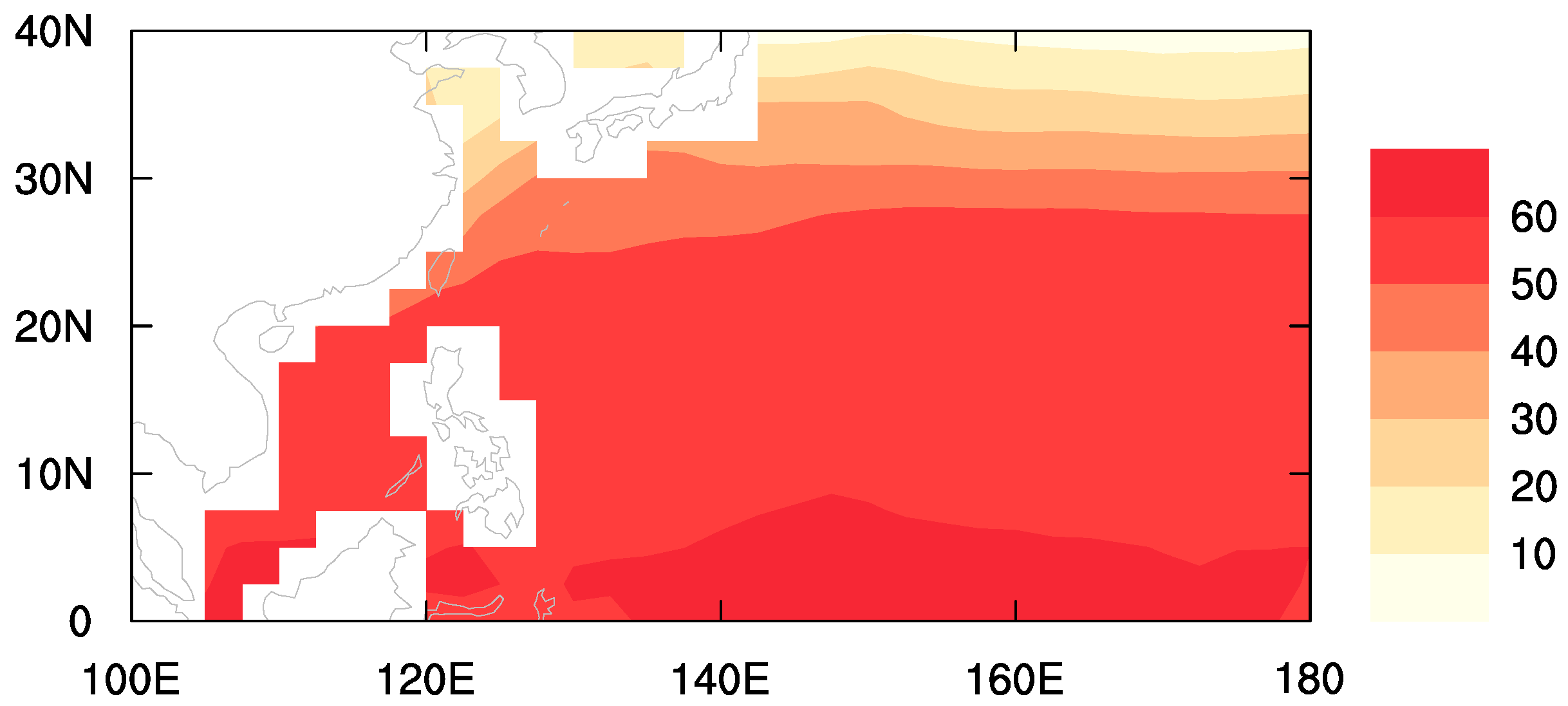
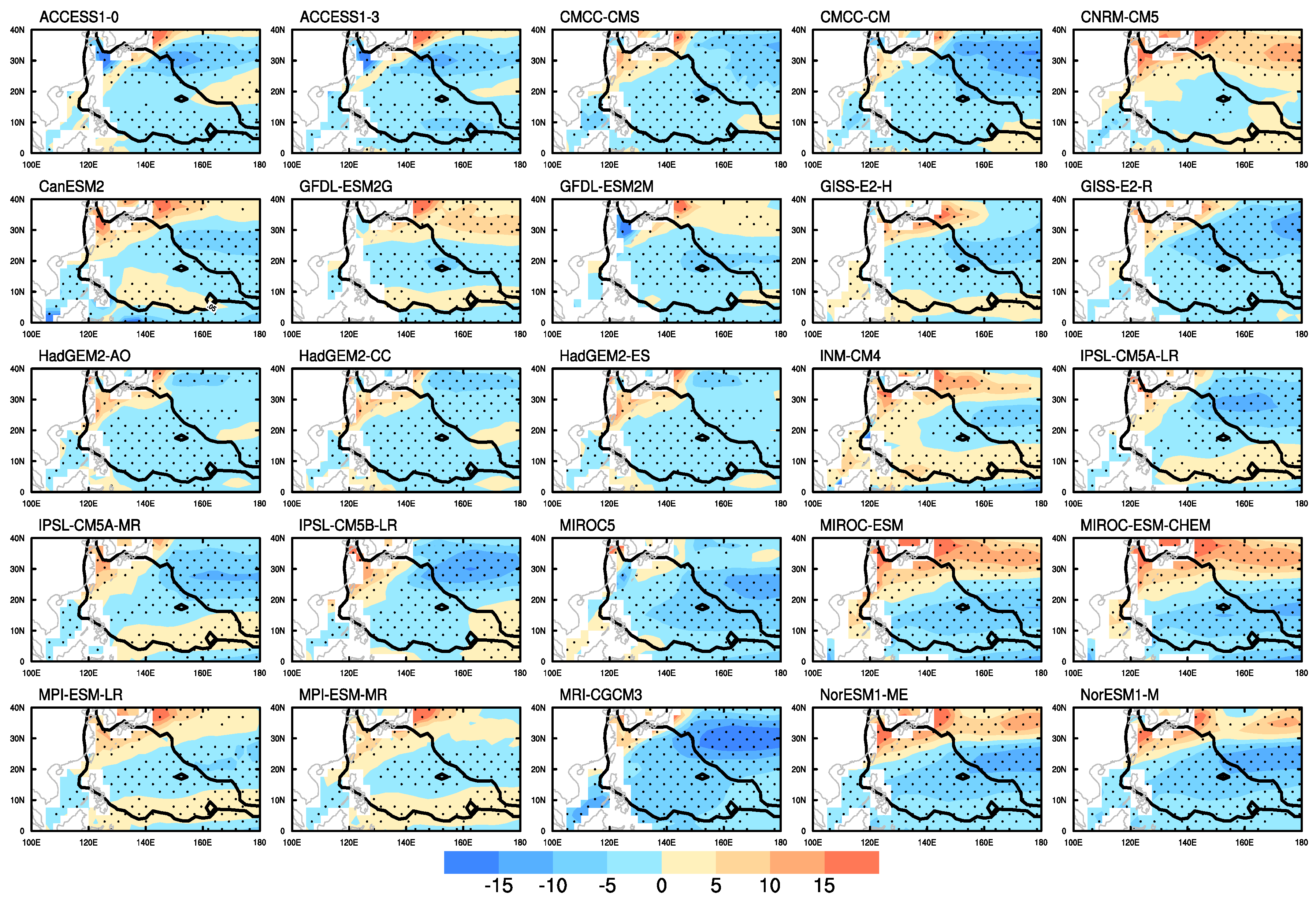
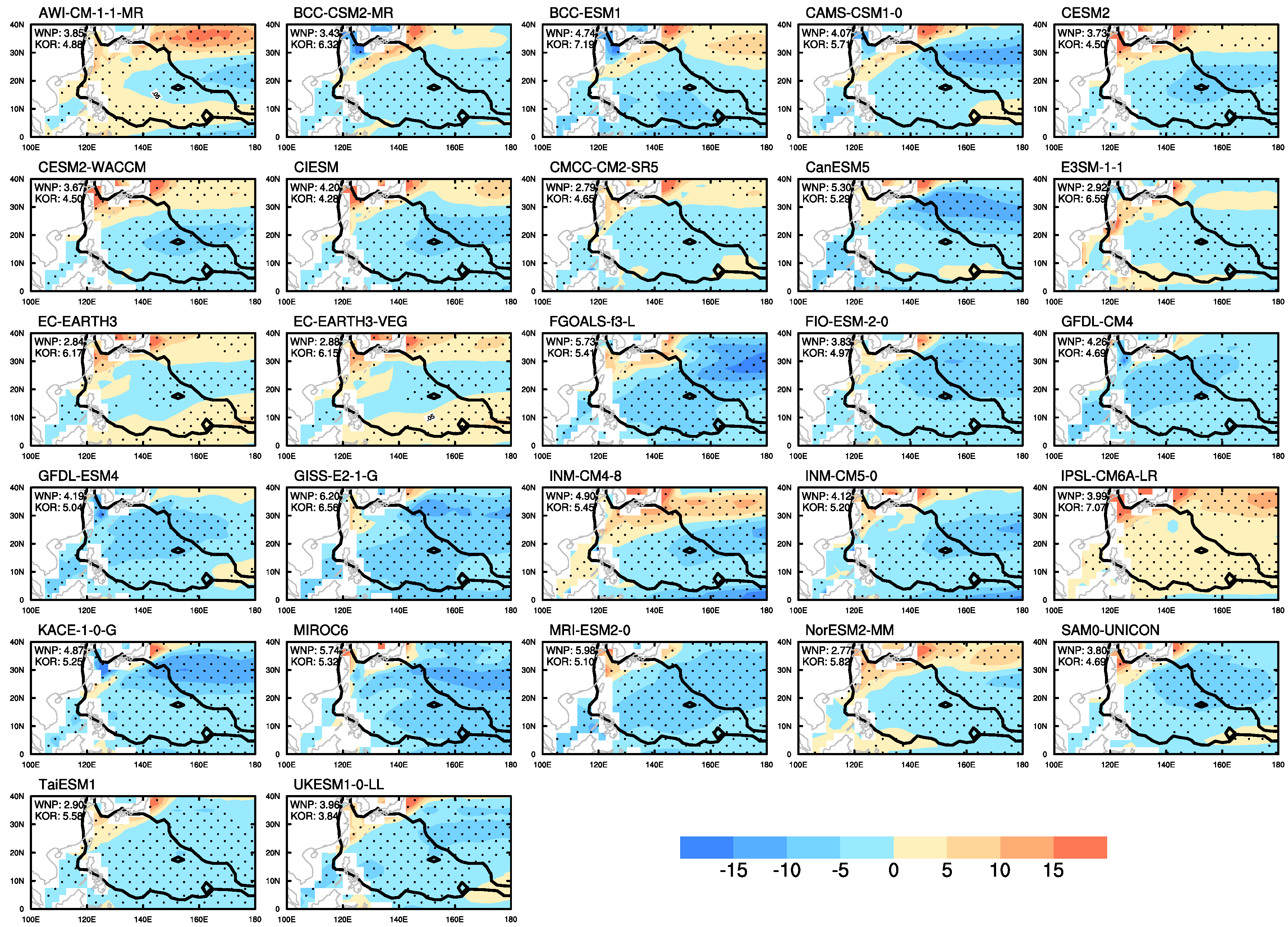
2. Data and Methods
3. Results
4. Conclusions
Author Contributions
Funding
Institutional Review Board Statement
Informed Consent Statement
Data Availability Statement
Acknowledgments
Conflicts of Interest
Abbreviations
| TC | Tropical Cyclone |
| CMIP | Coupled Model Intercomparison Project |
| PI | Potential Intensity |
| KOR PI | PI over TC passage to South Korea |
| WNP | western North Pacific |
| WNP PI | PI over the entire western North Pacific |
| SST | sea surface temperatur |
| ERA | ECMWF reanalysis |
| OBS | observation |
| COR | correlation |
| NSTD | normalized standard deviation |
References
- Walsh, K.J.E.; Camargo, S.J.; Vecchi, G.A.; Daloz, A.S.; Elsner, J.; Emanuel, K.; Horn, M.; Lim, Y.K.; Roberts, M.; Patricola, C.; et al. Hurricanes and Climate: The U.S. CLIVAR Working Group on Hurricanes. Bull. Am. Meteorol. Soc. 2015, 96, 997–1017. [Google Scholar] [CrossRef]
- Taylor, K.E.; Stouffer, R.J.; Meehl, G.A. An overview of CMIP5 and the experiment design. Bull. Am. Meteorol. Soc. 2012, 93, 485–498. [Google Scholar] [CrossRef] [Green Version]
- Eyring, V.; Bony, S.; Meehl, G.A.; Senior, C.A.; Stevens, B.; Stouffer, R.J.; Taylor, K.E. Overview of the Coupled Model Intercomparison Project Phase 6 (CMIP6) experimental design and organization. Geosci. Model Dev. 2016, 9, 1937–1958. [Google Scholar] [CrossRef] [Green Version]
- Camargo, S.J. Global and regional aspects of tropical cyclone activity in the CMIP5 models. J. Clim. 2013, 26, 9880–9902. [Google Scholar] [CrossRef] [Green Version]
- Bister, M.; Emanuel, K.A. Low frequency variability of tropical cyclone potential intensity 1. Interannual to interdecadal variability. J. Geophys. Res. Atmos. 2002, 107, ACL 26-1–ACL 26-15. [Google Scholar] [CrossRef]
- Knutson, T.R.; Sirutis, J.J.; Vecchi, G.A.; Garner, S.; Zhao, M.; Kim, H.S.; Bender, M.; Tuleya, R.E.; Held, I.M.; Villarini, G. Dynamical downscaling projections of twenty-first-century atlantic hurricane activity: CMIP3 and CMIP5 model-based scenarios. J. Clim. 2013, 26, 6591–6617. [Google Scholar] [CrossRef]
- Ting, M.; Camargo, S.J.; Li, C.; Kushnir, Y. Natural and Forced North Atlantic Hurricane Potential Intensity Change in CMIP5 Models. J. Clim. 2015, 28, 3926–3942. [Google Scholar] [CrossRef]
- Song, Y.; Wang, L.; Lei, X.; Wang, X. Tropical cyclone genesis potential index over the western North Pacific simulated by CMIP5 models. Adv. Atmos. Sci. 2015, 32, 1539–1550. [Google Scholar] [CrossRef]
- Sobel, A.H.; Camargo, S.J.; Hall, T.M.; Lee, C.Y.; Tippett, M.K.; Wing, A.A. Human influence on tropical cyclone intensity. Science 2016, 353, 242–246. [Google Scholar] [CrossRef] [PubMed] [Green Version]
- Held, I.M.; Zhao, M. The response of tropical cyclone statistics to an increase in CO2 with fixed sea surface temperatures. J. Clim. 2011, 24, 5353–5364. [Google Scholar] [CrossRef]
- Manganello, J.V.; Hodges, K.I.; Dirmeyer, B.; Kinter, J.L.; Cash, B.A.; Marx, L.; Jung, T.; Achuthavarier, D.; Adams, J.M.; Altshuler, E.L.; et al. Future changes in the western North Pacific tropical cyclone activity projected by a multidecadal simulation with a 16-km global atmospheric GCM. J. Clim. 2014, 27, 7622–7646. [Google Scholar] [CrossRef]
- Park, D.S.R.; Ho, C.H.; Nam, C.C.; Kim, H.S. Evidence of reduced vulnerability to tropical cyclones in the Republic of Korea. Environ. Res. Lett. 2015, 10, 054003. [Google Scholar] [CrossRef] [Green Version]
- Dee, D.P.; Uppala, S.M.; Simmons, A.J.; Berrisford, P.; Poli, P.; Kobayashi, S.; Andrae, U.; Balmaseda, M.A.; Balsamo, G.; Bauer, P.; et al. The ERA-Interim reanalysis: Configuration and performance of the data assimilation system. Q. J. R. Meteorol. Soc. 2011, 137, 553–597. [Google Scholar] [CrossRef]
- IPCC. Climate Change 2014: Synthesis Report. Contribution of Working Groups I, II and III to the Fifth Assessment Report of the Intergovernmental Panel on Climate Change; IPCC: Geneva, Switzerland, 2014; p. 151. [Google Scholar]
- Park, D.S.R.; Ho, C.H.; Kim, J.; Kang, K.R.; Nam, C.C. Highlighting socioeconomic damages caused by weakened tropical cyclones in the Republic of Korea. Nat. Hazards 2016, 82, 1301–1315. [Google Scholar] [CrossRef]
- Nam, C.C.; Park, D.S.R.; Ho, C.H.; Chen, D. Dependency of tropical cyclone risk on track in South Korea. Nat. Hazards Earth Syst. Sci. 2018, 18, 3225–3234. [Google Scholar] [CrossRef] [Green Version]
- Moon, I.J.; Kim, S.H.; Chan, J.C. Climate change and tropical cyclone trend. Nature 2019, 570, E3–E5. [Google Scholar] [CrossRef] [PubMed]
- Park, D.S.R.; Ho, C.H.; Kim, J.H.; Kim, H.S. Strong landfall typhoons in Korea and Japan in a recent decade. J. Geophys. Res. Atmos. 2011, 116, 7105. [Google Scholar] [CrossRef] [Green Version]
- Available online: https://emanuel.mit.edu/products (accessed on 20 December 2020).
- Emanuel, K.A. The dependence of hurricane intensity on climate. Nature 1987, 326, 483–485. [Google Scholar] [CrossRef]
- Taylor, K.E. Summarizing multiple aspects of model performance in a single diagram. J. Geophys. Res. Atmos. 2001, 106, 7183–7192. [Google Scholar] [CrossRef]
- Wilcoxon, F. Individual Comparisons by Ranking Methods. In Breakthroughs in Statistics; Kotz, S., Johnson, N.L., Eds.; Springer: New York, NY, USA, 1992; pp. 196–202. [Google Scholar] [CrossRef]
- Kim, Y.H.; Min, S.K.; Zhang, X.; Sillmann, J.; Sandstad, M. Evaluation of the CMIP6 multi-model ensemble for climate extreme indices. Weather Clim. Extrem. 2020, 29, 100269. [Google Scholar] [CrossRef]
- Kim, M.K.; Yu, D.G.; Oh, J.S.; Byun, Y.H.; Boo, K.O.; Chung, I.U.; Park, J.S.; Park, D.S.R.; Min, S.K.; Sung, H.M. Performance Evaluation of CMIP5 and CMIP6 Models on Heatwaves in Korea and Associated Teleconnection Patterns. J. Geophys. Res. Atmos. 2020, 125, e2020JD032583. [Google Scholar] [CrossRef]


| CMIP5 | Resolutions (Latitude × Longitude) | CMIP6 | Resolutions (Latitude × Longitude) |
|---|---|---|---|
| ACCESS1-0 | 1.25 × 1.875 | AWI-CM-1-1-MR | 0.9375 × 0.9375 |
| ACCESS1-3 | 1.25 × 1.875 | BCC-CSM2-MR | 1.125 × 1.125 |
| CMCC-CMS | 3.7111 × 3.75 | BCC-ESM1 | 2.8125 × 2.8125 |
| CNRM-CM5 | 1.4008 × 1.40625 | CAMS-CSM1-0 | 1.125 × 1.125 |
| CanESM2 | 2.7906 × 2.8125 | CESM2 | 0.9375 × 1.25 |
| GFDL-ESM2G | 2.0225 × 2 | CESM2-WACCM | 0.9375 × 1.25 |
| GFDL-ESM2M | 2.0225 × 2 | CIESM | 0.9375 × 1.25 |
| GISS-E2-H | 2 × 2.5 | CMCC-CM2-SR5 | 0.9375 × 1.25 |
| GISS-E2-R | 2 × 2.5 | CanESM5 | 2.8125 × 2.8125 |
| HadGEM2-AO | 1.25 × 1.875 | E3SM-1-1 | 1 × 1 |
| HadGEM2-CC | 1.25 × 1.875 | EC-EARTH3 | 0.703125 × 0.703125 |
| HadGEM2-ES | 1.25 × 1.875 | EC-EARTH3-VEG | 0.703125 × 0.703125 |
| INM-CM4 | 1.5 × 2 | FGOALS-f3-L | 1 × 1.25 |
| IPSL-CM5A-LR | 1.8947 × 3.75 | FIO-ESM-2-0 | 0.9375 × 1.25 |
| IPSL-CM5A-MR | 1.2676 × 2.5 | GFDL-CM4 | 1 × 1.25 |
| IPSL-CM5B-LR | 1.8947 × 3.75 | GFDL-ESM4 | 1 × 1.25 |
| MIROC5 | 1.4008 × 1.40625 | GISS-E2-1-G | 2 × 2.5 |
| MIROC-ESM | 2.7906 × 2.8125 | INM-CM4-8 | 1.5 × 2 |
| MIROC-ESM-CHEM | 2.7906 × 2.8125 | INM-CM5-0 | 1.5 × 2 |
| MPI-ESM-LR | 1.8653 × 1.875 | IPSL-CM6A-LR | 1.25 × 2.5 |
| MPI-ESM-MR | 1.8653 × 1.875 | KACE-1-0-G | 1.25 × 1.875 |
| MRI-CGCM3 | 1.12148 × 1.125 | MIROC6 | 1.40625 × 1.40625 |
| NorESM1-ME | 1.8947 × 2.5 | MRI-ESM2-0 | 1.125 × 1.125 |
| NorESM1-M | 1.8947 × 2.5 | NorESM2-MM | 0.9375 × 1.25 |
| SAM0-UNICON | 0.9375 × 1.25 | ||
| TaiESM1 | 0.9375 × 1.25 | ||
| UKESM1-0-LL | 1.25 × 1.875 |
| WNP PI | KOR PI | ||||||
|---|---|---|---|---|---|---|---|
| |NSTD-1| | COR | RMSE (Bias-Removed) | |NSTD-1| | COR | RMSE (Bias-Removed) | ||
| CMIP5 | 0.10 | 0.93 | 5.40 | 0.29 | 0.81 | 4.24 | |
| CMIP6 | 0.10 | 0.95 | 4.73 | 0.24 | 0.90 | 3.58 | |
| Difference (CMIP6 minus CMIP5) | 0.00 | 0.02 | −0.67 | −0.05 | 0.09 | −0.66 | |
| p-value (t-test) | 0.899 | 0.053 * | 0.058 * | 0.245 | 0.011 ** | 0.019 ** | |
| p-value (rank sum test) | 0.756 | 0.111 | 0.227 | 0.305 | 0.018 ** | 0.050 * | |
Publisher’s Note: MDPI stays neutral with regard to jurisdictional claims in published maps and institutional affiliations. |
© 2021 by the authors. Licensee MDPI, Basel, Switzerland. This article is an open access article distributed under the terms and conditions of the Creative Commons Attribution (CC BY) license (https://creativecommons.org/licenses/by/4.0/).
Share and Cite
Park, D.-S.R.; Kim, H.-S.; Kwon, M.; Byun, Y.-H.; Kim, M.-K.; Chung, I.-U.; Park, J.-S.; Min, S.-K. A Performance Evaluation of Potential Intensity over the Tropical Cyclone Passage to South Korea Simulated by CMIP5 and CMIP6 Models. Atmosphere 2021, 12, 1214. https://doi.org/10.3390/atmos12091214
Park D-SR, Kim H-S, Kwon M, Byun Y-H, Kim M-K, Chung I-U, Park J-S, Min S-K. A Performance Evaluation of Potential Intensity over the Tropical Cyclone Passage to South Korea Simulated by CMIP5 and CMIP6 Models. Atmosphere. 2021; 12(9):1214. https://doi.org/10.3390/atmos12091214
Chicago/Turabian StylePark, Doo-Sun R., Hyeong-Seog Kim, Minho Kwon, Young-Hwa Byun, Maeng-Ki Kim, Il-Ung Chung, Jeong-Soo Park, and Seung-Ki Min. 2021. "A Performance Evaluation of Potential Intensity over the Tropical Cyclone Passage to South Korea Simulated by CMIP5 and CMIP6 Models" Atmosphere 12, no. 9: 1214. https://doi.org/10.3390/atmos12091214