
The Role of Aquatic Refuge Habitats for Fish, and Threats in the Context of Climate Change and Human Impact, during Seasonal Hydrological Drought in the Saxon Villages Area (Transylvania, Romania)

 ,
,  , ,
, ,  and
and
Abstract
:1. Introduction and Background
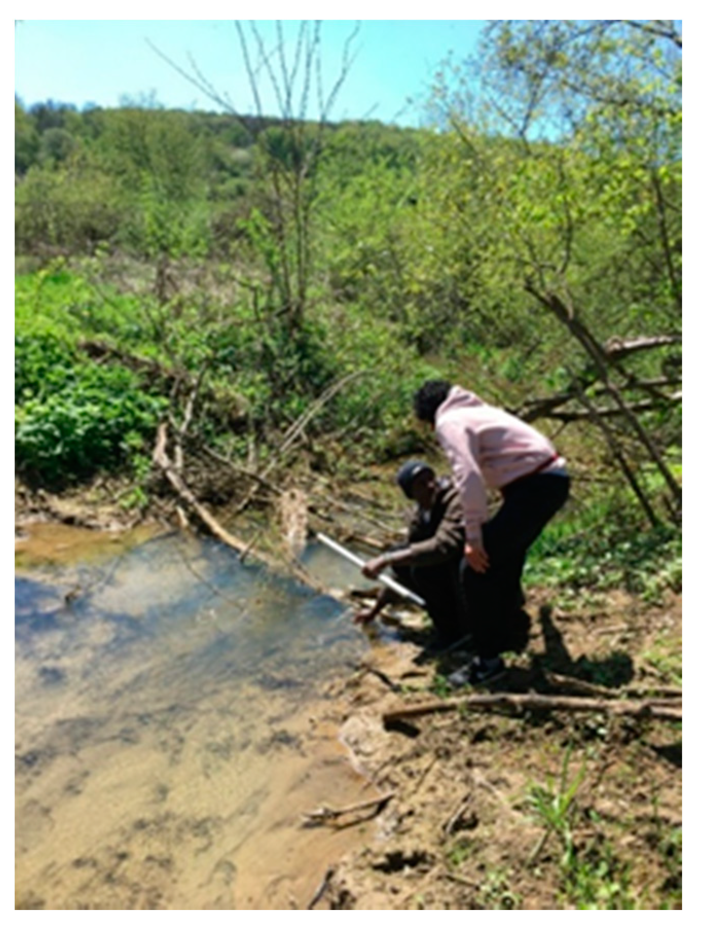
2. Materials and Methods
3. Results
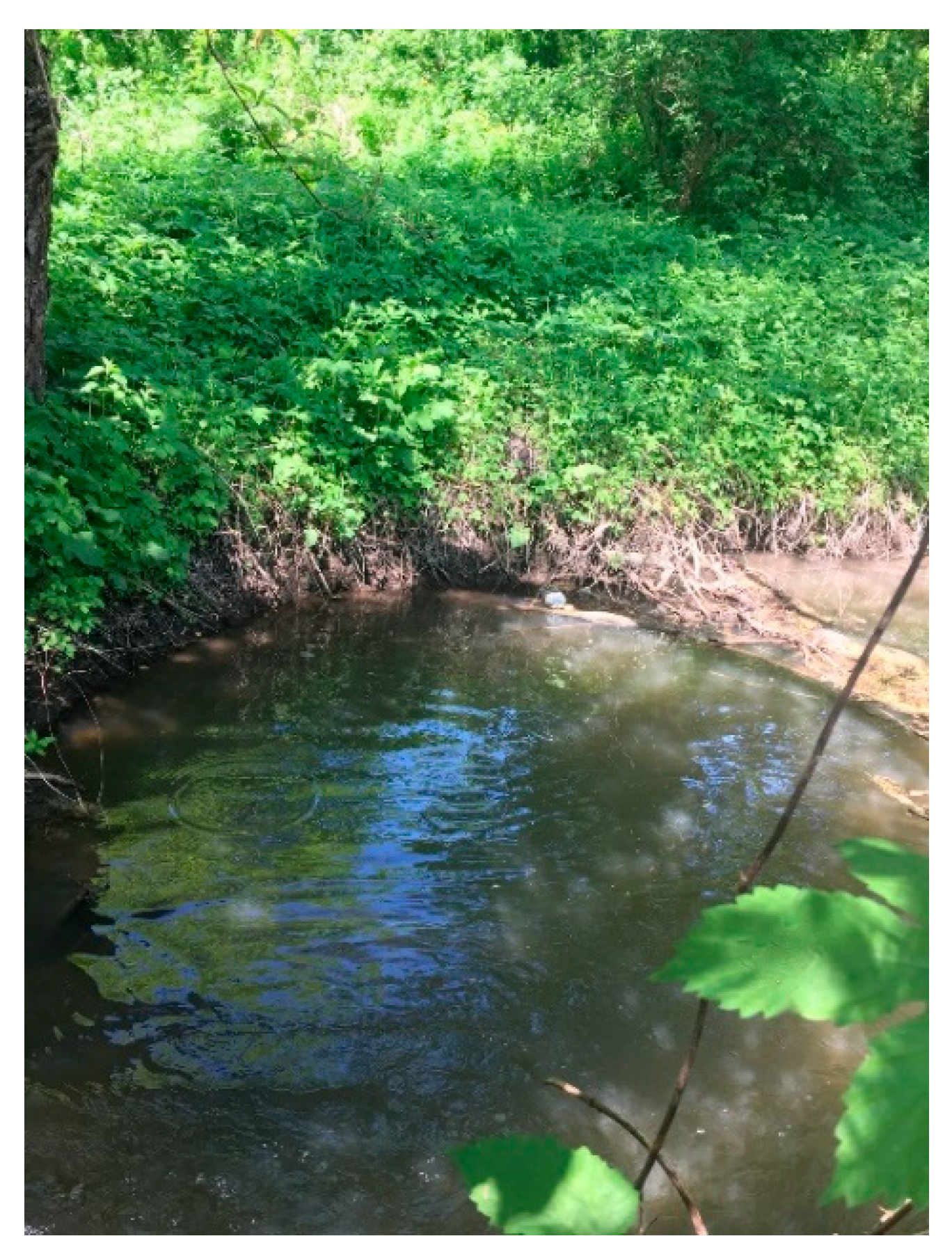
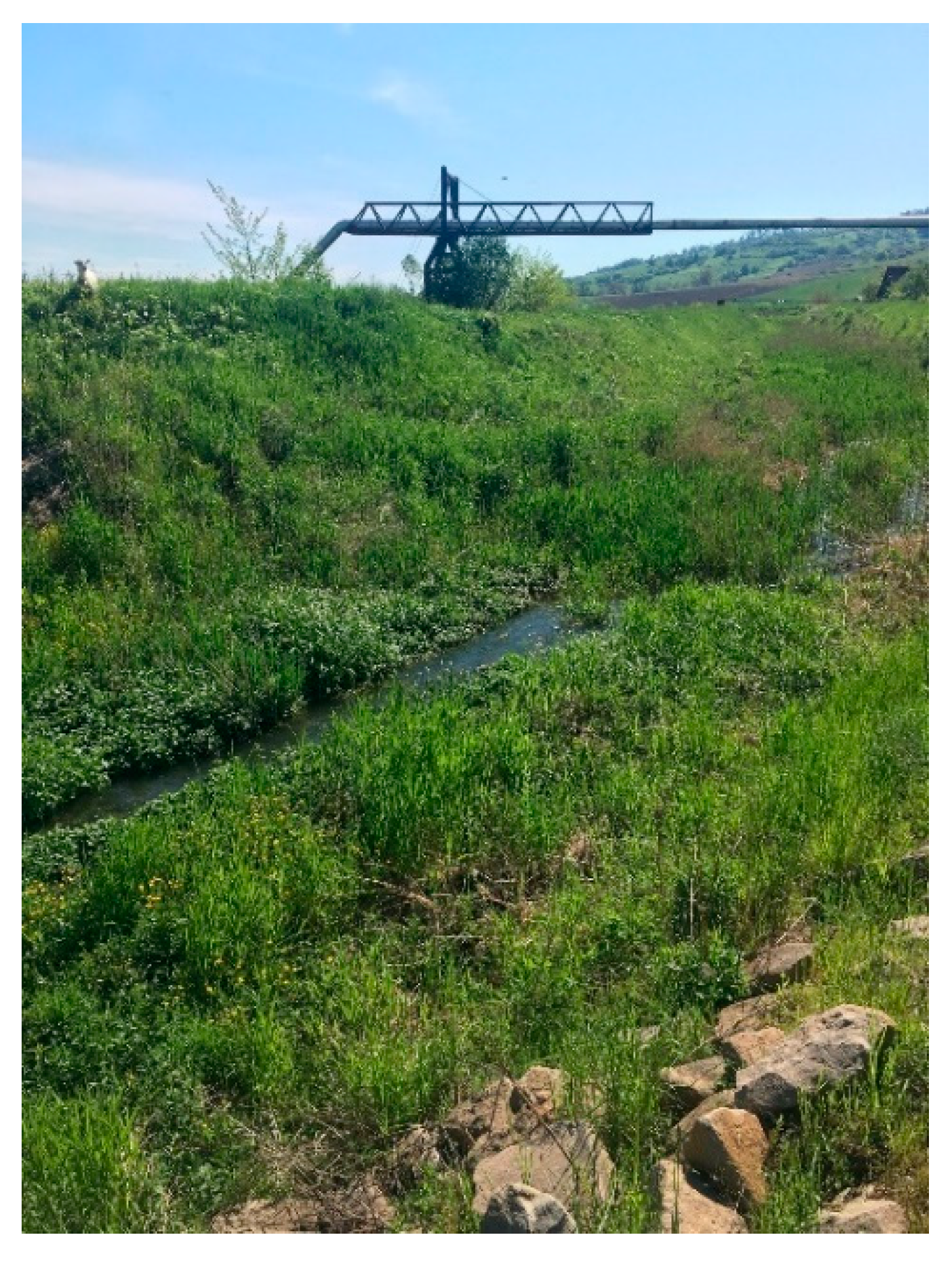
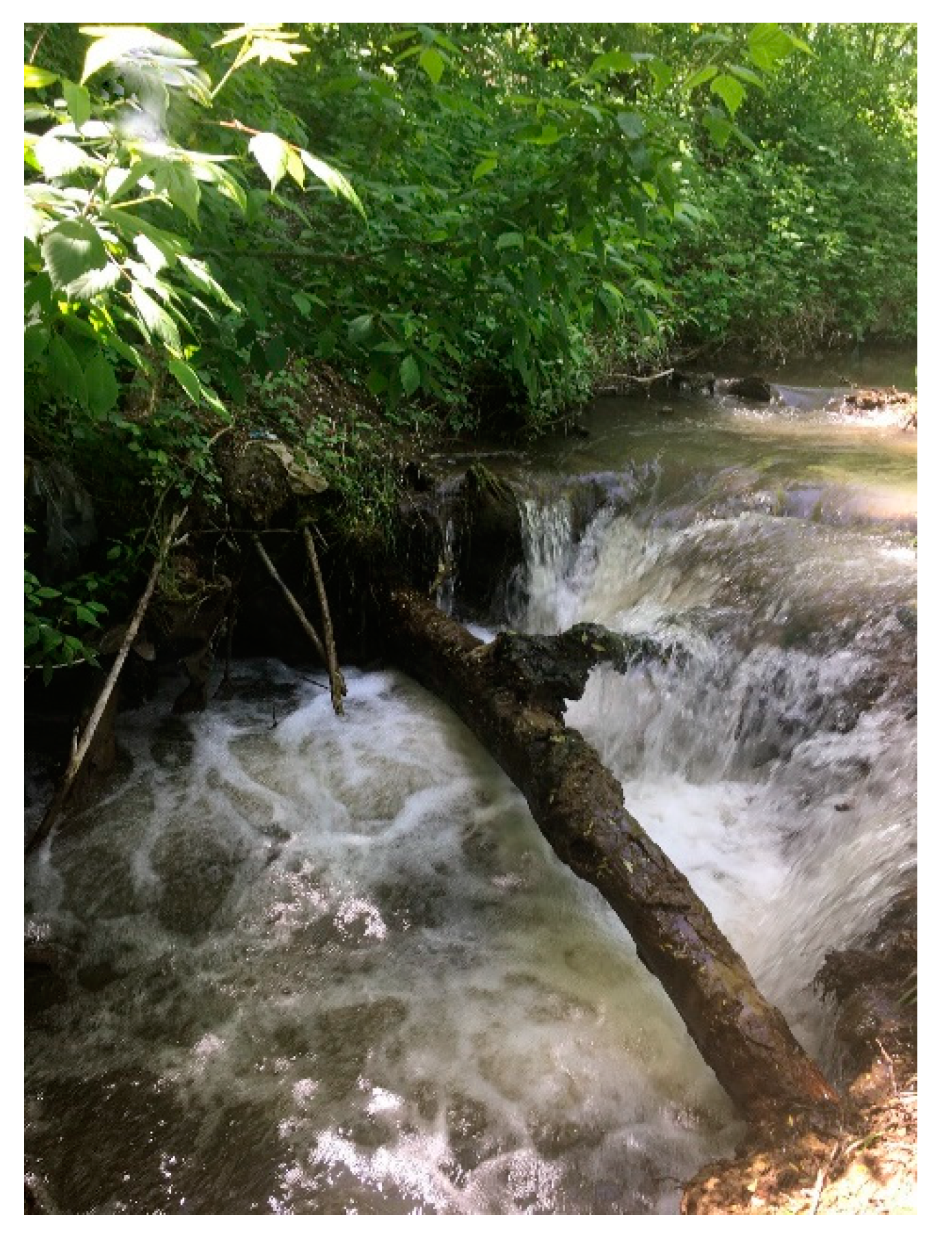
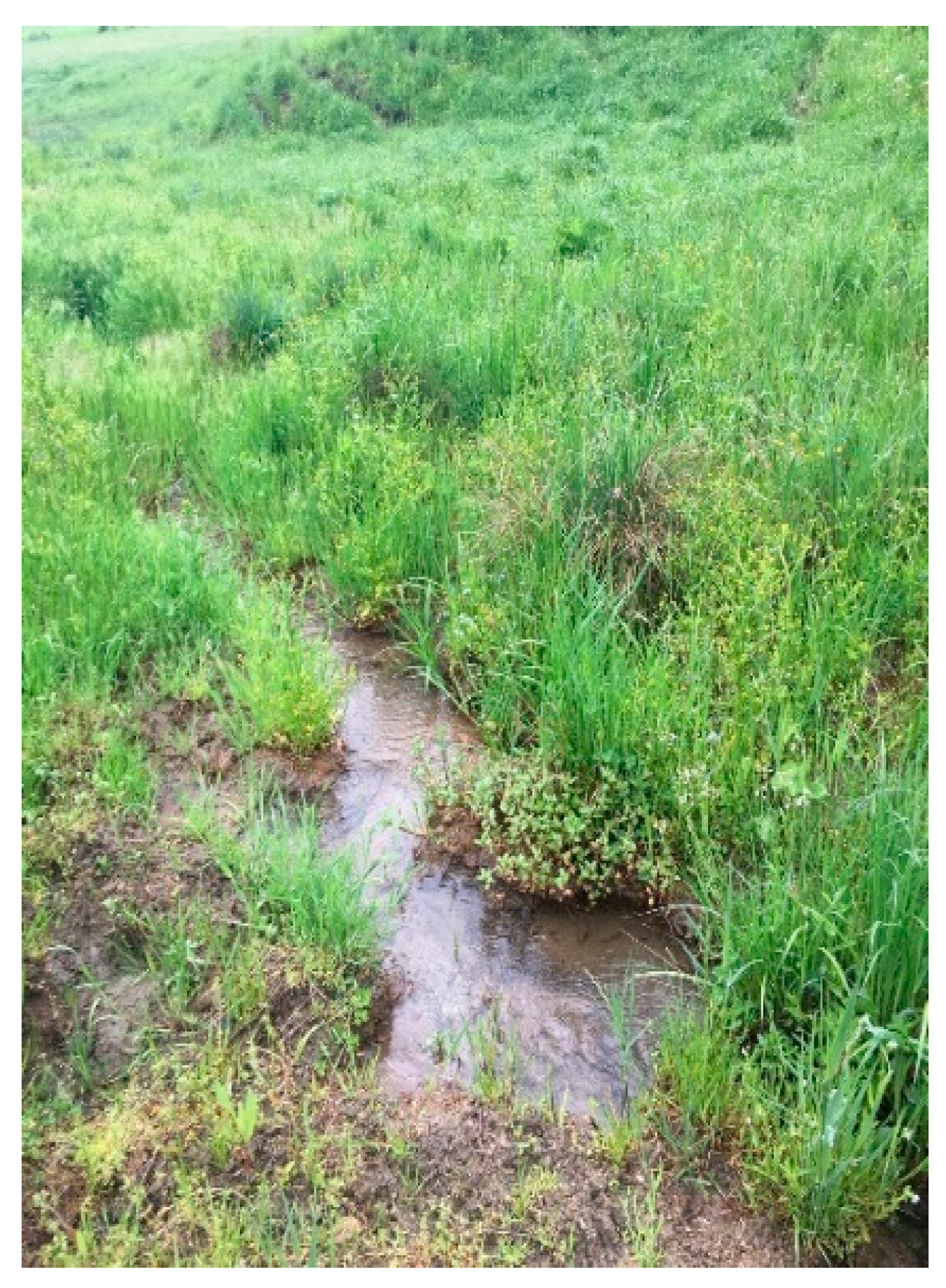
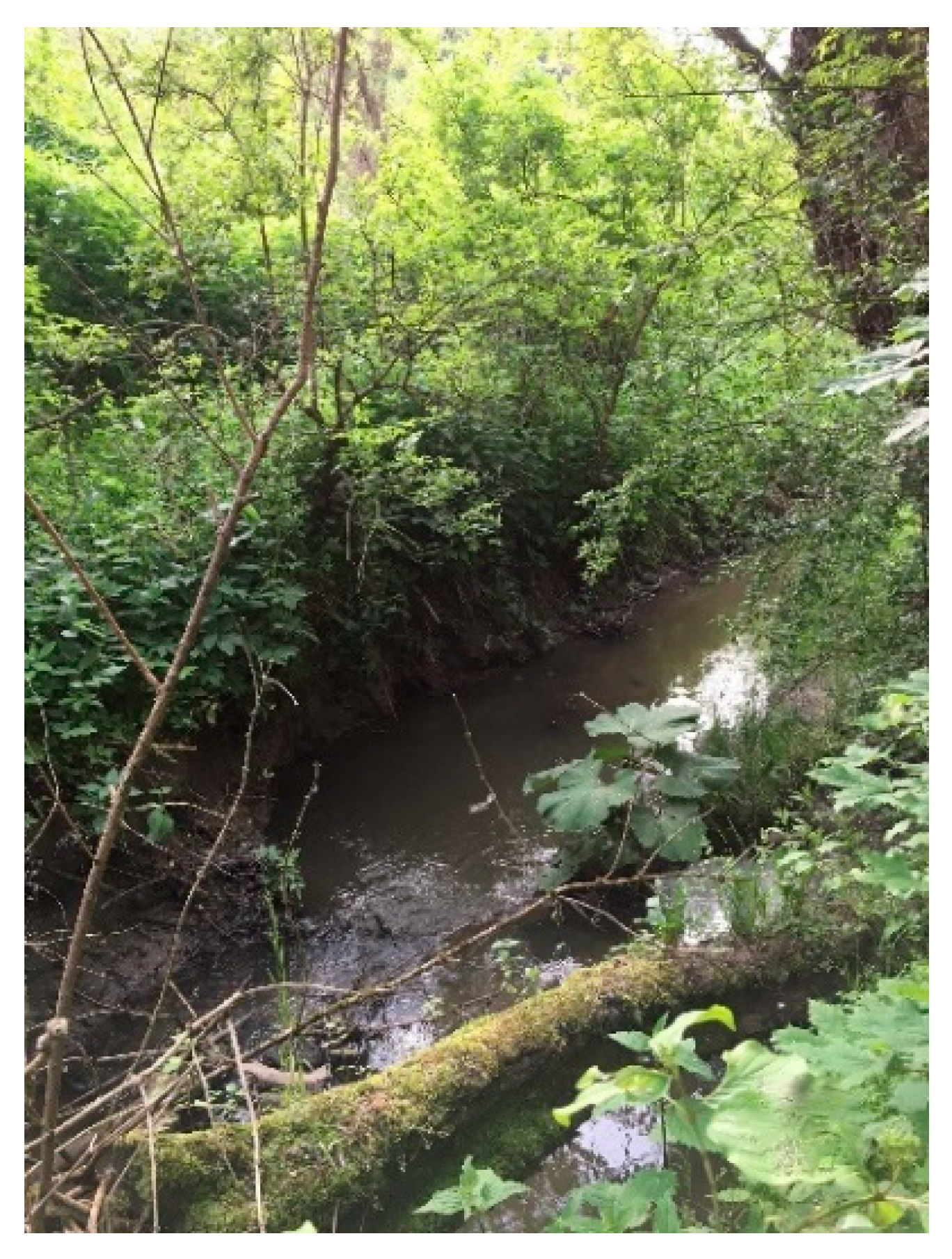
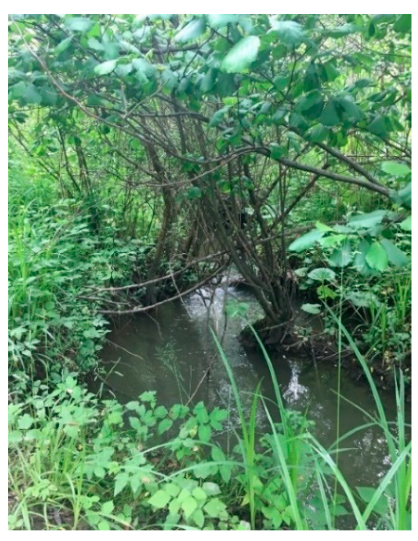
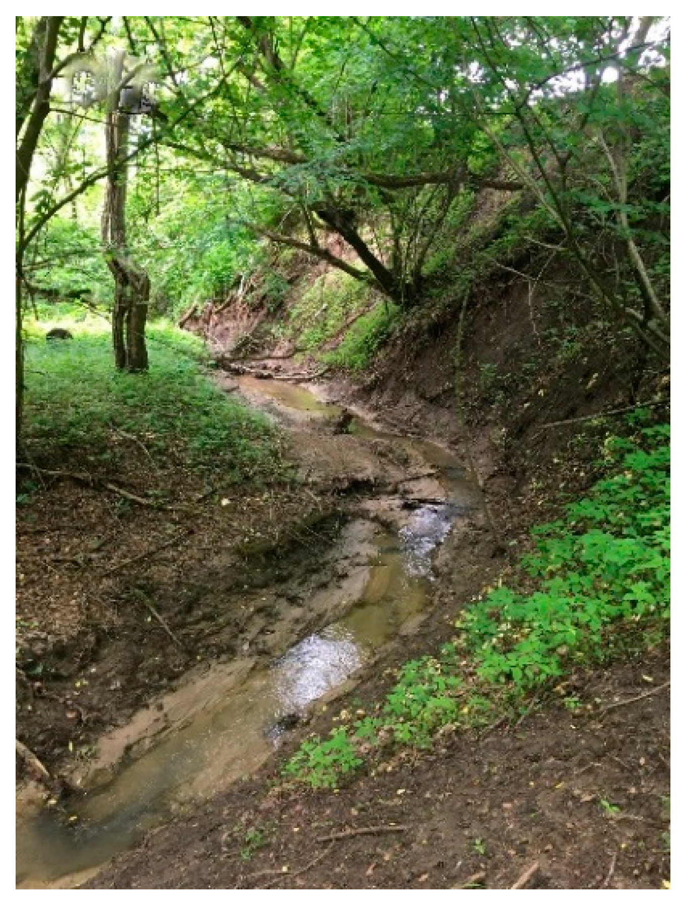
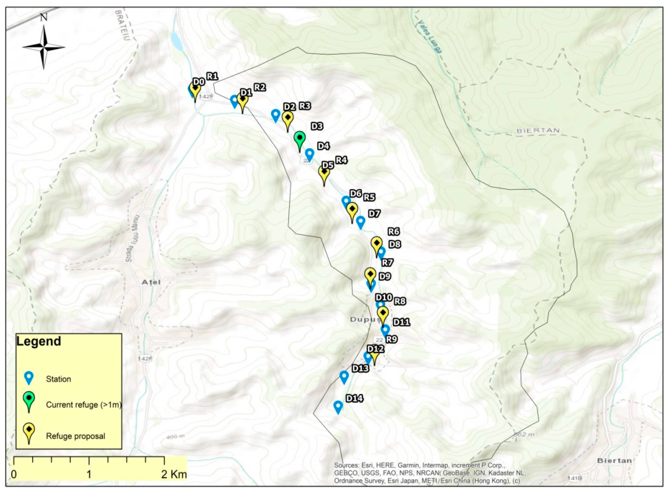
3.1. Dupuş River
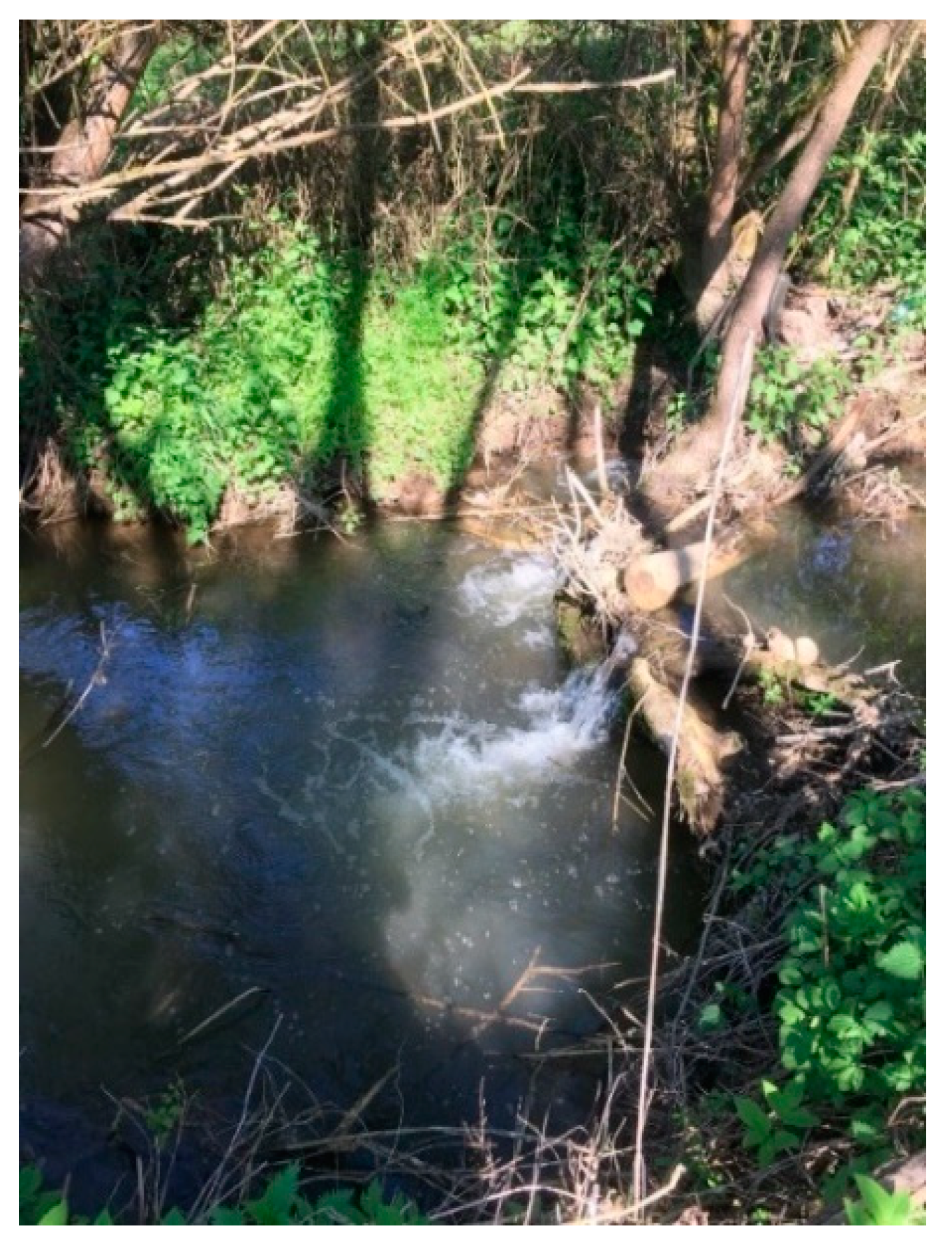
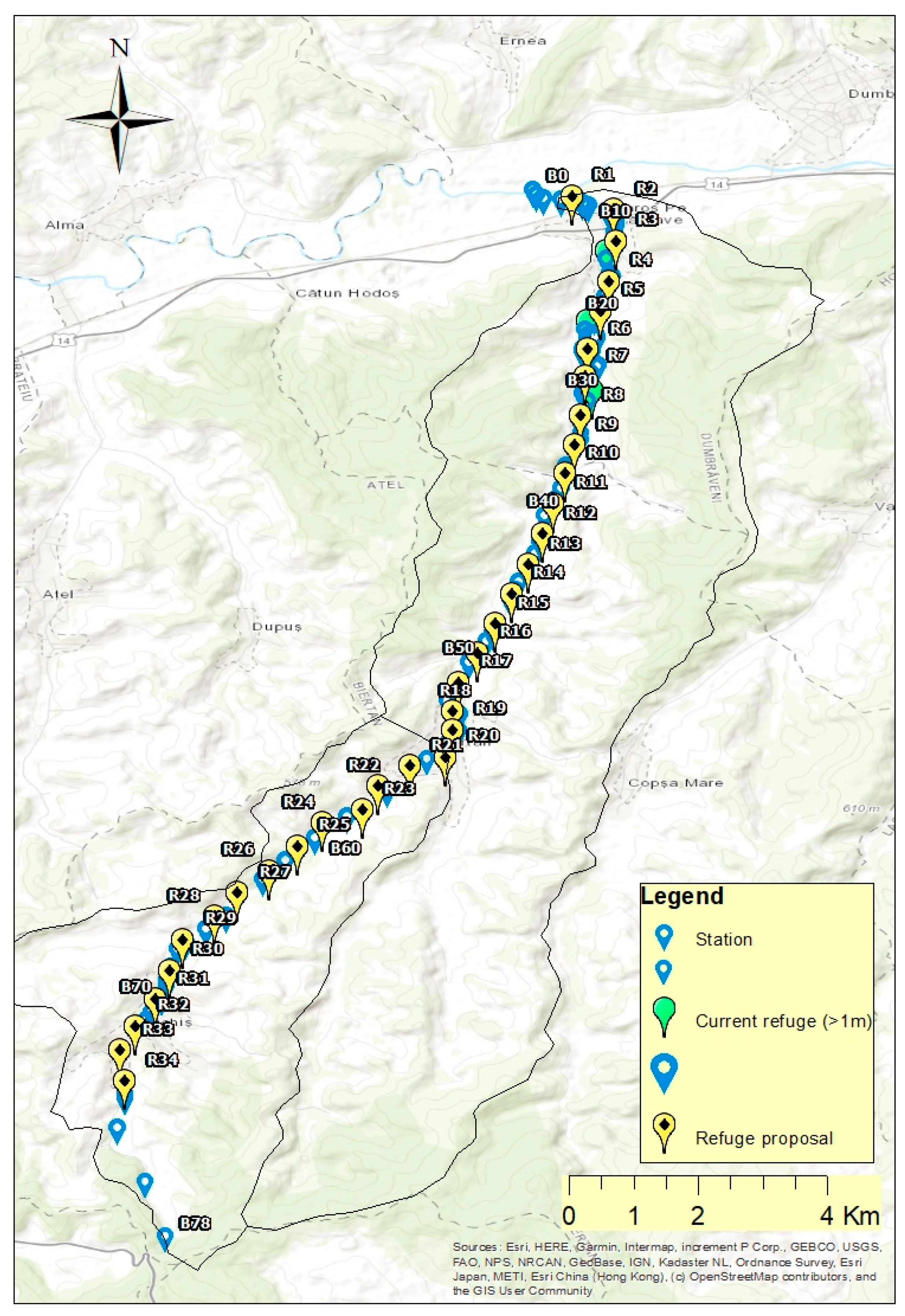
3.2. Biertan River
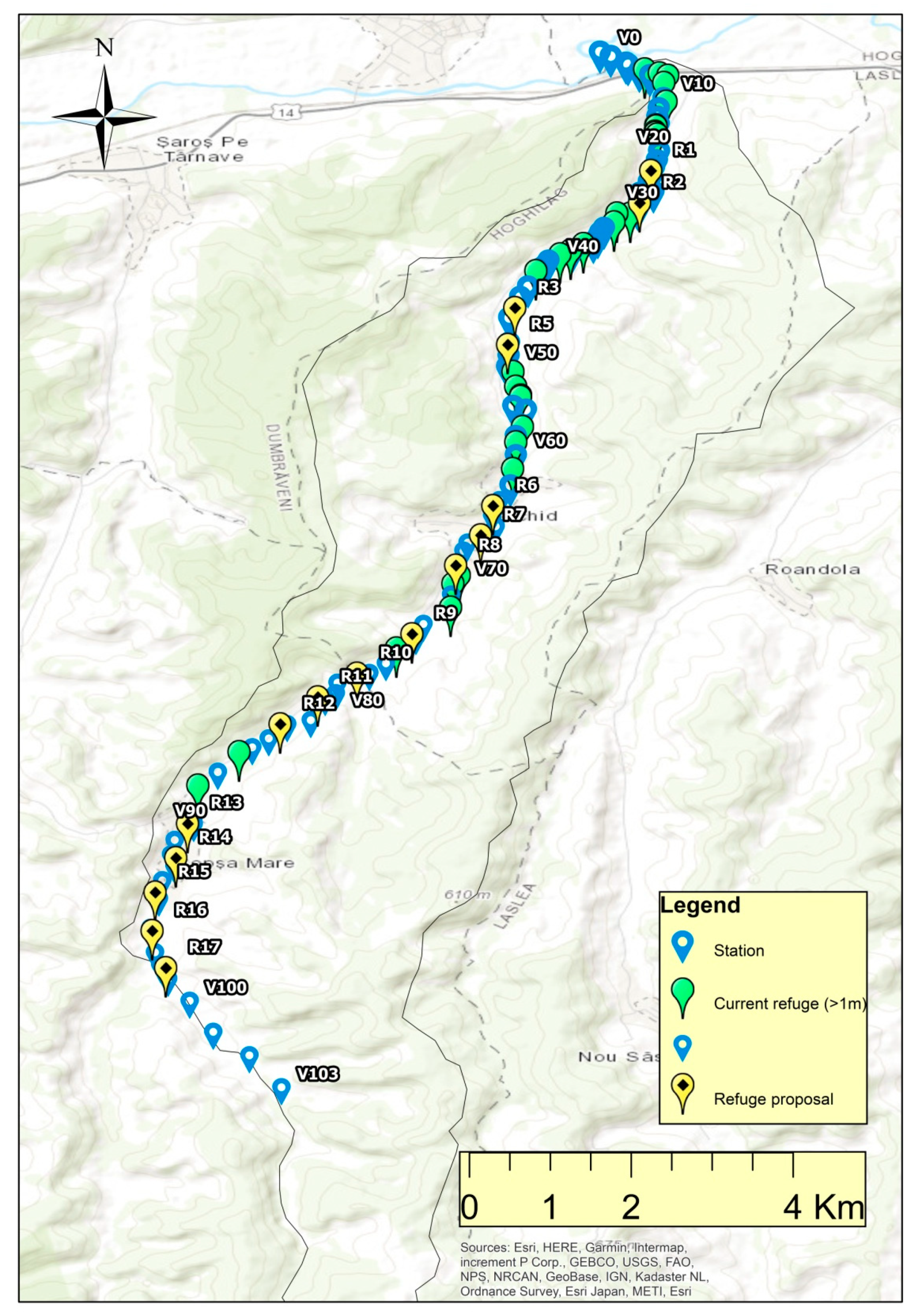
3.3. Valchid River
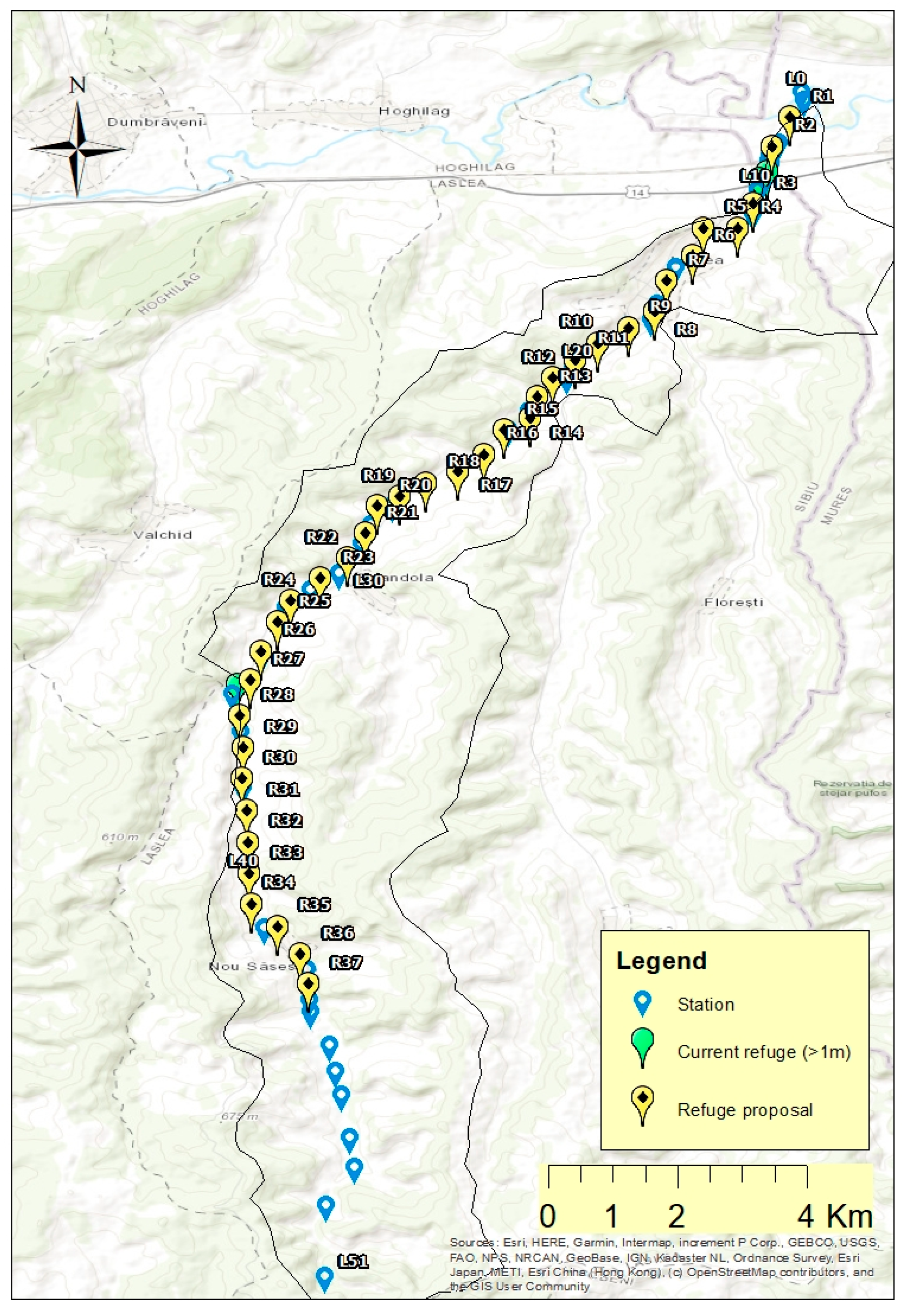
3.4. Laslea River
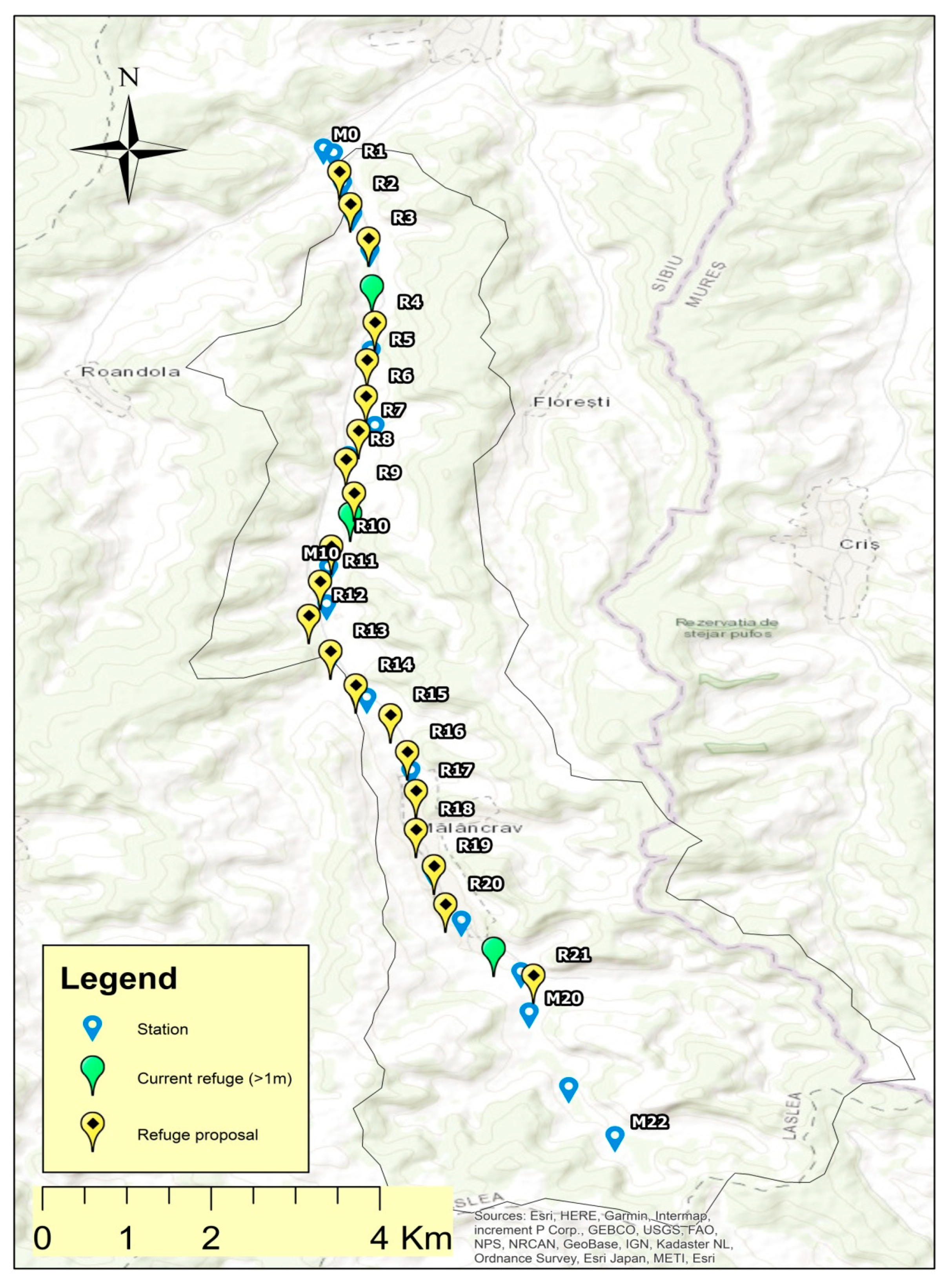
3.5. Mălâncrav River
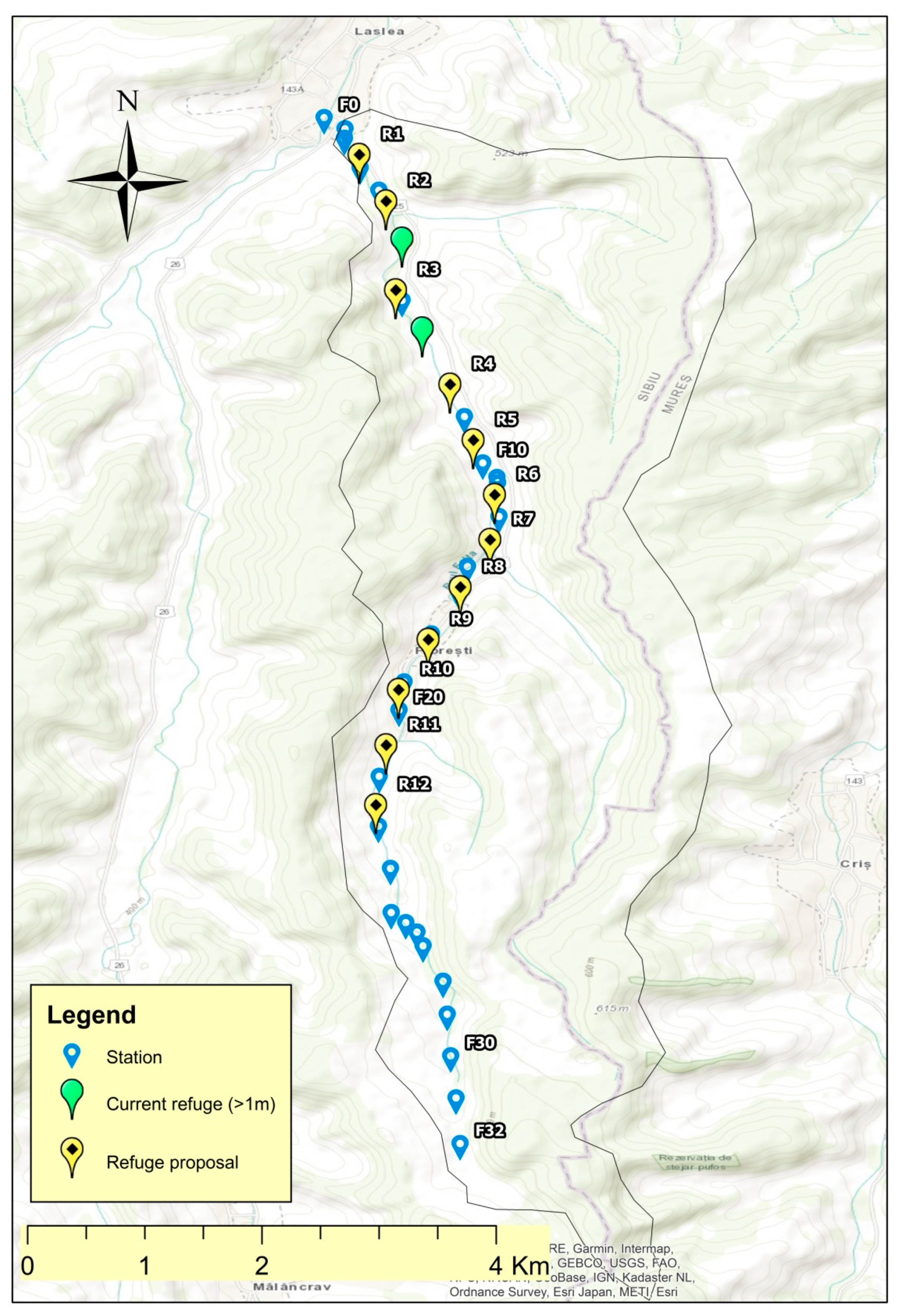
3.6. Felţa River
4. Discussion
4.1. Identified Ecological State Elements
4.2. Fish Fauna Refuge Habitats Management Elements Proposals
5. Conclusions
Author Contributions
Funding
Institutional Review Board Statement
Informed Consent Statement
Data Availability Statement
Acknowledgments
Conflicts of Interest
Appendix A

| Station Code | R-Refuge/M-Downstream Refuge Sector | Refuge Depth (cm) | Banks Description | Land Use | Substrate | Banks Height (m) | Fish Presence | Minor Riverbed Width (cm) | GPS Coordinates | Others |
|---|---|---|---|---|---|---|---|---|---|---|
| A1D0 | R | 35 | Arboreal layer | Arable | Oozy | 3 | 70 | 46°10′46.0″ N 24°28′20.6″ E | Lush vegetation and branches in the riverbed | |
| AD1 | R | 80 | Arboreal layer | Arable | Oozy | 0.5 | 70 | 46°10′41.6″ N 24°28′39.2″ E | 100 m upstream accumulation lake with fish, probably holiday house, rush, floodplain | |
| A1D2 | R | 50 | Arboreal layer | Arable | Oozy | 1 | + | 100 | 46°10′36.6″ N 24°28′57.3″ E | Downstream 100 m from the lake, lush vegetation, plastic wastes |
| A1D3 | R | 150 | Arboreal layer | Arable | Oozy | 0.5 | 120 | 46°10′24.9″ N 24°29′06.6″ E | Meander, sheep farm, metal, plastic, textile waste | |
| A1D4 | R | 30 | Arboreal layer | Grassland | Oozy | 0.5 | 60 | 46°10′24.9″ N 24°29′06.7″ E | Lush vegetation | |
| A1D5 | R | 60 | Arboreal layer | Arable | Oozy | 3 | 60 | 46°10′11.0″ N 24°29′18.1″ E | Bridge, furniture waste | |
| A1D6 | R | 30 | Arboreal layer | Arable | Oozy | 3 | 50 | 46°10′00.0″ N 24°29′27.0″ E | Rush | |
| A1D7 | M | 20 | Arboreal layer | Arable | Sandy | 2 | + | 60 | 46°09′51.5″ N 24°29′32.6″ E | Sheep farm |
| A1D8 | M | 20 | Shrub layer | Arable | Oozy | 2 | 60 | 46°09′38.8″ N 24°29′41.1″ E | Rush, Plastic wastes | |
| A1D9 | M | 20 | Shrub layer | Arable | Oozy | 2 | 40 | 46°09′25.5″ N 24°29′37.6″ E | Wool waste, construction (brick, tile), at the entrance in Dupus village | |
| A1D10 | M | 15 | Shrub layer | In locality | Oozy | 1.5 | 30 | 46°09′15.7″ N 24°29′41.7″ E | Minor riverbed with grass vegetation | |
| A1D11 | M | 15 | Shrub layer | In locality | Sandy | 2 | 35 | 46°09′06.3″ N 24°29′43.7″ E | ||
| A1D12 | M | 15 | Shrub layer | In locality | Sandy | 1.5 | 35 | 46°08′54.9″ N 24°29′36.7″ E | ||
| A1D13 | M | 15 | Shrub layer | Arable | Oozy | 2 | 35 | 46°08′47.3″ N 24°29′25.8″ E | At the exit of the village, branches in the riverbed | |
| A1D14 | M | 10 | Shrub layer and arboreal | Pasture | Oozy | 0.5 | 20 | 46°08′38.3″ N 24°29′23.3″ E | Rush, cattle farm, close to the river source |
| Station Code | R-Refuge/M-Downstream Refuge Sector | Refuge Depth (cm) | Banks Description | Land Use | Substrate | Banks Height (m) | Fish Presence | Minor Riverbed Width (cm) | GPS Coordinates | Others |
|---|---|---|---|---|---|---|---|---|---|---|
| A2B0 | R | 75 | Arboreal layer and grass | Arable | Oozy | 5 | + | 200 | 46°12′50.3″ N 24°32′04.7″ E | Confluence with Tarnava Mare (close to the road and railway |
| A2B1 | R | 35 | Shrub and arboreal layer | Arable | Oozy | 4 | 150 | 46°12′51.3″ N 24°32′04.1″ E | ||
| A2B2 | R | 50 | Arboreal layer | Arable | Oozy | 4 | 200 | 46°12′45.4″ N 24°32′08.0″ E | Plastic waste | |
| A2B3 | R | 60 | Shrub layer | Arable | Oozy | 2 | 150 | 46°12′46.3″ N 24°32′17.4″ E | Waste metal, plastic, textiles | |
| A2B4 | R | 55 | Shrub layer | Arable | Oozy | 2 | 150 | 46°12′46.0″ N 24°32′17.5″ E | Rush, polystyrene, plastic waste | |
| A2B5 | R | 55 | Grass layer | Arable | Oozy | 3 | 300 | 46°12′44.4″ N 24°32′23.9″ E | Concreted banks, near the railway bridge | |
| A2B6 | M | 25 | Grass layer | Pasture | Oozy, concreted | 3 | 400 | 46°12′42.3″ N 24°32′30.1″ E | Banks and bed of the river concreted on a length of 30 m | |
| A2B7 | R | 40 | Grass layer | Arable and pasture | Oozy | 2 | 100 | 46°12′42.3″ N 24°32′30.8″ E | Reeds, gardens | |
| A2B8 | R | 60 | Grass layer | Arable and In locality | Oozy | 2 | 150 | 46°12′40.5″ N 24°32′40.3″ E | Entrance to Saros on Tarnave | |
| A2B9 | R | 35 | Grass layer | In locality | Oozy | 2 | 150 | 46°12′40.5″ N 24°32′40.5″ E | In the village, Saros on Tarnave, drenate banks, stone nets | |
| A2B10 | R | 65 | Grass layer | In locality | Oozy | 2 | 150 | 46°12′32.7″ N 24°32′46.8″ E | Sewer holes, untreated wastewater, plastic waste, manure dumps | |
| A2B11 | R | 60 | Grass layer | In locality | Oozy | 2 | + | 100 | 46°12′27.9″ N 24°32′45.7″ E | Sewer holes, untreated wastewater, plastic waste, manure dumps |
| A2B12 | R | 50 | Grass layer | In locality | Oozy | 2 | 100 | 46°12′22.5″ N 24°32′44.6″ E | Discharge of wastewater, traces and smell of detergents | |
| A2B13 | R | 100 | Grass layer | In locality | Oozy | 1.5 | 100 | 46°12′18.2″ N 24°32′41.8″ E | Discharge of wastewater | |
| A2B14 | R | 45 | Grass layer and shrub | In locality | Oozy | 1.5 | 100 | 46°12′18.2″ N 24°32′41.8″ E | Plastic waste, rush | |
| A2B15 | R | 40 | Grass layer | In locality | Oozy | 1.5 | + | 100 | 46°12′09.0″ N 24°32′39.7″ E | |
| A2B16 | R | 60 | Grass layer | In locality and pasture | Oozy | 1.5 | + | 100 | 46°12′07.7″ N 24°32′39.2″ E | Pumping from the river for irrigation |
| A2B17 | R | 55 | Grass layer | Pasture | Oozy | 2 | 150 | 46°11′58.0″ N 24°32′40.9″ E | Plastic waste | |
| A2B18 | R | 40 | Shrub layer | Pasture | Oozy | 2 | 150 | 46°11′52.7″ N 24°32′37.9″ E | ||
| A2B19 | R | 70 | Shrub layer | Pasture | Oozy | 2 | + | 200 | 46°11′52.1″ N 24°32′38.6″ E | |
| A2B20 | R | 90 | Arboreal layer | Arable | Oozy | 1.5 | 150 | 46°11′45.2″ N 24°32′39.0″ E | Sector with meanders and fallen trees in the minor riverbed | |
| A2B21 | R | 100 | Arboreal layer | Arable | Oozy | 1.5 | 150 | 46°11′42.0″ N 24°32′31.3″ E | Plastic waste | |
| A2B22 | R | 60 | Arboreal layer | Arable | Oozy | 2 | 150 | 46°11′42.2″ N 24°32′31.1″ E | Hard to reach, twigs | |
| A2B23 | R | 65 | Arboreal layer | Arable | Oozy | 2 | 150 | 46°11′36.1″ N 24°32′32.7″ E | ||
| A2B24 | M | 25 | Arboreal layer | Arable | Oozy | 2 | 150 | 46°11′28.4″ N 24°32′30.9″ E | Plastic waste | |
| A2B25 | R | 95 | Arboreal layer | Arable | Oozy | 2 | 150 | 46°11′28.2″ N 24°32′30.7″ E | Fallen branches in the minor riverbed, many nettles, traces of deer crossing | |
| A2B26 | R | 80 | Arboreal layer | Arable | Oozy | 1.5 | 150 | 46°11′25.6″ N 24°32′31.3″ E | Meandered sector, with high meanders, low flow speed | |
| A2B27 | R | 55 | Arboreal layer | Arable | Oozy | 2 | 150 | 46°11′21.4″ N 24°32′35.1″ E | Meandering, bridge crossing | |
| A2B28 | R | 25 | Shrub layer | Arable and grass | Oozy | 2 | 200 | 46°11′14.2″ N 24°32′30.0″ E | ||
| A2B29 | R | 80 | Shrub layer | Arable and grass | Oozy | 2 | 200 | 46°13′16.6″ N 24°33′01.7″ E | Plastic waste | |
| A2B30 | R | 40 | Arboreal layer | Arable and grass | Oozy | 1.5 | 200 | 46°13′16.6″ N 24°33′01.7″ E | ||
| A2B31 | R | 120 | Arboreal layer | Arable and grass | Oozy | 1.5 | 200 | 46°11′06.7″ N 24°32′32.4″ E | Large meanders, sheepfold without animals probably present by cows | |
| A2B32 | R | 45 | Grass layer and arboreal | Arable | Oozy | 1.5 | 150 | 46°11′09.3″ N 24°32′27.3″ E | Floodplain | |
| A2B33 | R | 40 | Grass layers and arboreal | Arable | Oozy | 5.5 | 150 | 46°13′16.9″ N 24°33′01.8″ E | ||
| A2B34 | M | 25 | Arboreal layer | Arable | Oozy | 3 | 150 | 46°13′16.9″ N 24°33′01.8″ E | ||
| A2B35 | R | 55 | Shrub layer | Arable | Oozy | 2 | 150 | 46°10′55.1″ N 24°32′26.5″ E | ||
| A2B36 | R | 70 | Shrub layer | Arable and grassland | Oozy | 2 | 200 | 46°10′44.7″ N 24°32′27.1″ E | ||
| A2B37 | R | 80 | Arboreal layer | Arable and grassland | Oozy | 3 | 200 | 46°10′44.7″ N 24°32′27.1″ E | ||
| A2B38 | R | 30 | Arboreal layer | Arable | Oozy | 5 | 200 | 46°10′31.2″ N 24°32′21.1″ E | ||
| A2B39 | R | 45 | Arboreal layer | Arable | Oozy | 6 | 150 | 46°10′31.2″ N 24°32′21.1″ E | Landslide, denuded shore, meander, poultry farm across the street | |
| A2B40 | R | 70 | Arboreal layer | Arable | Oozy | 5 | 200 | 46°13′05.2″ N 24°32′42.2″ E | Wildly | |
| A2B41 | R | 70 | Arboreal layer | Arable and grassland | Oozy | 4 | 150 | 46°13′04.3″ N 24°32′58.4″ E | ||
| A2B42 | R | 40 | Shrub layer | Arable | Oozy | 4 | 150 | 46°09′51.7″ N 24°32′06.1″ E | Wildly | |
| A2B43 | R | 60 | Grass layer and arboreal | Arable | Oozy | 4 | 150 | 46°09′58.3″ N 24°32′07.8″ E | Plastic waste, fallen trees in the minor riverbed | |
| A2B44 | R | 60 | Grass layer and arboreal | Arable | Oozy | 4 | 150 | 46°09′49.0″ N 24°32′04.1″ E | ||
| A2B45 | M | 20 | Shrub layer and arboreal | Arable and pasture | Rocky | 2 | 150 | 46°09′47.4″ N 24°32′04.6″ E | Construction and plastic waste, possible sheep farm, traces of wool on branches | |
| A2B46 | R | 40 | Arboreal layer | Arable | Oozy | 4 | 150 | 46°09′33.3″ N 24°31′56.4″ E | ||
| A2B47 | R | 45 | Shrub layer and arboreal | Arable | Oozy | 4.5 | 200 | 46°09′16.1″ N 24°31′47.1″ E | Wild, hard to reach, closed by shrub vegetation | |
| A2B48 | R | 65 | Shrub layer | Arable | Oozy | 4 | 200 | 46°09′10.1″ N 24°31′43.9″ E | ||
| A2B49 | R | 45 | Shrub layer | Arable | Oozy | 4 | 200 | 46°09′04.2″ N 24°31′40.7″ E | Steep banks | |
| A2B50 | R | 120 | Shrub layer | Arable | Oozy | 1.5 | 200 | 46°08′58.6″ N 24°31′37.1″ E | Many plastics waste, twig dam, cloudy water | |
| A2B51 | R | 40 | Shrub layer | Arable | Oozy | 3 | 150 | 46°08′39.2″ N 24°31′24.6″ E | ||
| A2B52 | M | 25 | Shrub layer | In locality | Oozy | 2 | 150 | 46°08′32.7″ N 24°31′20.5″ E | ||
| A2B53 | R | 35 | Grass layer | In locality | Oozy | 2 | 150 | 46°08′34.5″ N 24°31′21.8″ E | ||
| A2B54 | M | 25 | Shrub layer | In locality | Oozy | 2 | 150 | 46°08′32.7″ N 24°31′20.5″ E | ||
| A2B55 | M | 25 | Shrub layer | In locality | Oozy | 2 | 150 | 46°08′18.4″ N 24°31′26.8″ E | In the village, bridge under construction, river channeled through pipes | |
| A2B56 | M | 20 | Shrub layer | In locality | Oozy | 2 | 150 | 46°08′05.3″ N 24°31′14.8″ E | ||
| A2B57 | M | 25 | Shrub layer | In locality | Oozy | 1.5 | 150 | 46°08′05.3″ N 24°31′14.8″ E | ||
| A2B58 | R | 35 | Shrub layer | Arable | Oozy | 2 | 150 | 46°08′04.3″ N 24°31′09.2″ E | ||
| A2B59 | R | 35 | Arboreal layer | Arable | Oozy | 2 | 150 | 46°08′02.8″ N 24°31′05.1″ E | ||
| A2B60 | R | 35 | Arboreal layer | Arable | Oozy | 1.5 | 150 | 46°07′59.3″ N 24°31′01.5″ E | ||
| A2B61 | R | 35 | Shrub layer | Arable and grassland | Oozy | 1.5 | 100 | 46°07′13.8″ N 24°29′59.2″ E | ||
| A2B62 | R | 30 | Shrub layer | Arable | Oozy | 2 | 100 | 46°06′59.2″ N 24°29′41.8″ E | ||
| A2B63 | R | 55 | Arboreal layer | Pasture | Oozy | 2 | 150 | 46°06′46.8″ N 24°29′30.3″ E | Twigs in the minor riverbed | |
| A2B64 | R | 30 | Arboreal layer | Arable | Oozy | 2 | 150 | 46°06′47.4″ N 24°29′29.7″ E | Underarm clay | |
| A2B65 | R | 40 | Arboreal layer | Arable | Oozy | 2 | 100 | 46°06′31.7″ N 24°29′06.8″ E | Cow farm | |
| A2B66 | R | 35 | Grassy layer | Arable | Oozy | 2 | 55 | 46°06′29.2″ N 24°29′05.4″ E | ||
| A2B67 | R | 35 | Grass layer | Arable | Oozy | 2 | 60 | 46°06′23.8″ N 24°28′57.0″ E | ||
| A2B68 | R | 30 | Grass layer | Arable | Oozy | 2 | 80 | 46°06′13.2″ N 24°29′00.5″ E | ||
| A2B69 | M | 25 | Grass layer | In locality and Arable | Oozy | 1.5 | 55 | 46°06′10.2″ N 24°29′00.3″ E | ||
| A2B70 | M | 25 | Grass layer | In locality and Arable | Oozy | 1 | - | 55 | 46°05′56.7″ N 24°28′48.7″ E | Green water, eutrophication |
| A2B71 | M | 25 | Grass layer | In locality and Arable | Oozy | 1 | 55 | 46°05′59.0″ N 24°28′52.5″ E | Plastic waste | |
| A2B72 | M | 15 | Grass layer | In locality and Arable | Oozy | 55 | 46°05′58.1″ N 24°28′52.3″ E | Discharges of domestic water directly into the river | ||
| A2B73 | M | 20 | Grass layer and arboreal | In locality | Oozy | 1.5 | 55 | 46°05′37.7″ N 24°28′35.9″ E | Discharge of domestic water directly into the river | |
| A2B74 | M | 15 | Grass layer | In locality and arable | Oozy | 1.5 | 55 | 46°05′35.5″ N 24°28′35.4″ E | ||
| A2B75 | M | 15 | Grass layer and shrub | Pasture | Oozy | 2 | 55 | 46°05′14.4″ N 24°28′37.7″ E | ||
| A2B76 | R | 35 | Grass layer | Pasture | Oozy | 2 | 70 | 46°04′60.0″ N 24°28′34.8″ E | Plastic and electronic waste | |
| A2B77 | M | 15 | Grass layer | Pasture | Oozy | 0.5 | 50 | 46°05′00.7″ N 24°28′31.3″ E | Wetland, rush | |
| A2B78 | M | 5 | Arboreal layer | Pasture and Forest | 0.5 | - | 46°04′27.5″ N 24°28′40.2″ E | Spring area |
| Station Code | R-Refuge/M-Downstream Refuge Sector | Refuge Depth (cm) | Banks Description | Land Use | Substrate | Banks Height (m) | Fish Presence | Minor Riverbed Width (cm) | GPS Coordinates | Others |
|---|---|---|---|---|---|---|---|---|---|---|
| A3V0 | R | 60 | Shrub and arboreal layer | Pasture and arable | Oozy | 5 | + | 300 | 46°13′10.7″ N 24°35′52.9″ E | Valchid confluence with Tarnava Mare, near to the road |
| A3V1 | R | 35 | Shrub and arboreal layer | Pasture and arable | Oozy | 1 | + | 200 | 46°13′13.0″ N 24°35′48.9″ E | |
| A3V2 | R | 51 | Concreted banks | Pasture and arable | 3 | 200 | 46°13′12.1″ N 24°35′51.9″ E | River channeled on a portion of 5 m, upstream banks and concrete riverbed, road, railway | ||
| A3V3 | R | 27 | Concreted banks | Arable | 4 | 800 | 46°13′12.0″ N 24°35′52.1″ E | Succession of concrete thresholds of about 60 cm | ||
| A3V4 | R | 45 | Grassy layer | Arable | Oozy | 4 | 250 | 46°13′08.5″ N 24°35′56.7″ E | Boulder Dam | |
| A3V5 | R | 100 | Shrub layer | Arable | Oozy | 4 | 200 | 46°13′08.2″ N 24°35′59.1″ E | ||
| A3V6 | R | 80 | Arboreal layer | Arable | Oozy | 6 | + | 200 | 46°13′07.1″ N 24°36′01.3″ E | |
| A3V7 | R | 100 | Grassy and arboreal layer | Arable | Oozy | 4.5 | + | 200 | 46°13′06.6″ N 24°36′05.0″ E | |
| A3V8 | R | 120 | Grassy layer, Exposed shore, without trees | Arable | Oozy | 1.5 | 200 | 46°13′06.3″ N 24°36′08.8″ E | Low flow rate | |
| A3V9 | R | 130 | Shrub layer | Arable | Oozy | 2 | 200 | 46°13′02.8″ N 24°36′07.0″ E | ||
| A3V10 | M | no refuges, fleeting | Grassy layer and denuded banks | Arable | Oozy | 1.5 | 200 | 46°12′58.2″ N 24°36′07.2″ E | ||
| A3V11 | R | 110 | Arboreal layer | Arable | Oozy | 1 | 200 | 46°13′34.4″ N 24°37′52.6″ E | ||
| A3V12 | R | 35 | Arboreal layer | Arable | Oozy | 1.5 | 200 | 46°12′53.9″ N 24°36′04.9″ E | ||
| A3V13 | R | 85 | Arboreal layer | Arable | Oozy | 2 | 200 | 46°12′53.6″ N 24°36′05.9″ E | ||
| A3V14 | R | 40 | Arboreal layer | Arable | Oozy | 2 | 250 | 46°12′47.6″ N 24°36′04.9″ E | ||
| A3V15 | R | 150 | Arboreal layer | Arable | Oozy | 2 | 250 | 46°12′45.5″ N 24°36′03.8″ E | Cloudy water | |
| A3V16 | R | 100 | Arboreal layer | Arable | Oozy | 3 | 200 | 46°12′45.6″ N 24°36′03.8″ E | ||
| A3V17 | R | 120 | Arboreal layer | Arable | Oozy | 2 | 200 | 46°12′43.3″ N 24°36′03.4″ E | Beaver dam | |
| A3V18 | R | 102 | Arboreal layer | Pasture | Oozy | 2 | 150 | 46°12′43.0″ N 24°36′03.4″ E | ||
| A3V19 | R | 120 | Arboreal layer | Arable | Oozy | 200 | 46°12′42.3″ N 24°36′04.1″ E | |||
| A3V20 | R | 35 | Arboreal layer | Pasture | Oozy | 2 | 150 | 46°12′37.1″ N 24°36′03.9″ E | Household waste (plastic, pet, cardboard, textiles) | |
| A3V21 | R | 50 | Arboreal layer | Pasture | Oozy | 3 | 200 | 46°13′25.7″ N 24°36′36.1″ E | ||
| A3V22 | R | 30 | Arboreal layer | Pasture | Gravel, ballast | 2 | 150 | 46°12′39.4″ N 24°36′10.3″ E | ||
| A3V23 | M | Shallow depth | Arboreal layer | Pasture | Gravel, ballast | 2 | 150 | 46°12′39.4″ N 24°36′10.3″ E | ||
| A3V24 | R | 55 | Arboreal layer | Pasture | Oozy | 3 | 100 | 46°12′24.3″ N 24°36′01.0″ E | ||
| A3V25 | R | 65 | Arboreal layer | Pasture | Oozy | 3 | 100 | 46°12′20.4″ N 24°36′03.3″ E | ||
| A3V26 | R | 45 | Arboreal layer | Pasture | Oozy | 1.5 | 100 | 46°13′06.9″ N 24°36′26.9″ E | Secondary arm | |
| A3V27 | R | 70 | Arboreal layer | Pasture | Oozy | 2 | 100 | 46°13′16.9″ N 24°36′32.1″ E | ||
| A3V28 | R | 50 | Arboreal layer | Pasture | Oozy | 2 | 200 | 46°13′22.3″ N 24°36′34.8″ E | ||
| A3V29 | R | 100 | Arboreal layer | Arable | Oozy | 2 | 150 | 46°13′29.4″ N 24°36′38.5″ E | Foam stain of 1 m2, waste (pet, bran), fallen trees | |
| A3V30 | R | 160 | Arboreal layer | Arable | Oozy | 2 | 150 | 46°12′10.1″ N 24°35′48.5″ E | ||
| A3V31 | R | 120 | Arboreal layer | Arable | Oozy | 4 | 150 | 46°12′06.2″ N 24°35′47.1″ E | Low flow rate, 50 cm course width | |
| A3V32 | R | 60 | Arboreal layer | Pasture | Oozy | 2 | 100 | 46°12′05.3″ N 24°35′43.7″ E | Low flow rate, course width of 50 cm, forest | |
| A3V33 | R | 80 | Arboreal layer | Arable | Oozy | 2 | 150 | 46°12′03.3″ N 24°35′41.9″ E | ||
| A3V34 | R | 90 | Arboreal layer | Arable | Oozy | 3 | 150 | 46°12′01.7″ N 24°35′40.3″ E | ||
| A3V35 | R | 70 | Arboreal layer | Arable | Oozy | 3 | 180 | 46°11′59.9″ N 24°35′38.7″ E | ||
| A3V36 | R | 120 | Arboreal layer | Arable | Oozy | 2 | 220 | 46°11′57.6″ N 24°35′34.7″ E | ||
| A3V37 | M | 25 | Arboreal layer | Arable | 200 | 46°11′55.7″ N 24°35′30.0″ E | Sheepfold | |||
| A3V38 | R | 130 | Arboreal layer | Arable | Oozy | 3 | 150 | 46°11′55.7″ N 24°35′29.7″ E | Sheepfold | |
| A3V39 | R | 130 | Arboreal layer | Arable | Oozy | 3 | + | 180 | 46°11′56.6″ N 24°35′30.9″ E | |
| A3V40 | R | 75 | Arboreal layer | Arable | Oozy | 1.5 | + | 150 | 46°11′52.7″ N 24°35′20.9″ E | Sheepfold, culvert, in the summer the level drops by half, minimum flow provided almost all the time, in 2020 much weaker flow than so far in 2021 |
| A3V41 | R | 70 | Arboreal layer | Arable | Oozy | 2 | + | 46°11′49.5″ N 24°35′17.9″ E | ||
| A3V42 | R | 35 | Arboreal layer | Arable and Pasture | Oozy | 2 | + | 150 | 46°11′49.5″ N 24°35′18″ E | |
| A3V43 | R | 100 | Arboreal layer | Arable and Pasture | Oozy | 2 | + | 180 | 46°11′46.8″ N 24°35′15.6″ E | |
| A3V44 | R | 85 | Arboreal layer | Arable and Pasture | Oozy | 2 | + | 50 | 46°11′38.3″ N 24°35′09.4″ E | |
| A3V45 | R | 75 | Arboreal layer | Arable and Pasture | Oozy | 1.5 | 150 | 46°11′38.3″ N 24°35′10″ E | No human settlements, only three sheep farms | |
| A3V46 | R | 60 | Arboreal layer | Arable and Pasture | Oozy | 2 | 46°11′34.0″ N 24°34′58.6″ E | Many twigs in the water | ||
| A3V47 | R | 70 | Arboreal layer | Arable and Pasture | Oozy | 2 | 100 | 46°11′29.8″ N 24°35′04.7″ E | Waste (plastic, cardboard, electro-household) | |
| A3V48 | R | 45 | Arboreal layer | Arable | Oozy | 2 | 150 | 46°11′19.7″ N 24°35′02.1″ E | ||
| A3V49 | R | 100 | Arboreal layer | Arable | Oozy | 2 | 150 | 46°11′14.8″ N 24°35′04.7″ E | Waste (plastic) | |
| A3V50 | R | 100 | Arboreal layer | Arable | Oozy | 2 | 100 | 46°11′14.8″ N 24°35′04.7″ E | ||
| A3V51 | R | 180 | Arboreal layer | Arable, orchard | Oozy | 3 | 150 | 46°11′14.8″ N 24°35′04.7″ E | ||
| A3V52 | R | 175 | Arboreal layer | Arable | Oozy | 2 | 46°11′14.0″ N 24°35′08.4″ E | |||
| A3V53 | R | 150 | Arboreal layer | Arable | Oozy | 2 | 150 | 46°10′57.6″ N 24°35′09.5″ E | ||
| A3V54 | R | 160 | Arboreal layer | Arable | Oozy | 2 | 200 | 46°10′57.2″ N 24°35′09.6″ E | Dam of twigs | |
| A3V55 | R | 45 | Arboreal layer | Arable | Oozy | 2 | 46°10′58.9″ N 24°35′08.1″ E | |||
| A3V56 | R | 45 | Arboreal layer | Arable | Oozy | 2 | 46°10′54.5″ N 24°35′07.2″ E | |||
| A3V57 | R | 109 | Arboreal layer | Arable | Oozy | 1.5 | 170 | 46°10′45.1″ N 24°35′10.2″ E | Cattle farm | |
| A3V58 | R | 57 | Arboreal layer | Arable | Oozy | 2 | 120 | 46°10′42.7″ N 24°35′07.7″ E | Waste, we are approaching human settlements | |
| A3V59 | R | 110 | Arboreal layer | Arable | Oozy | 3 | 120 | 46°10′38.9″ N 24°35′07.4″ E | ||
| A3V60 | R | 30 | Arboreal layer | Arable, In locality | Oozy | 2 | 110 | 46°10′35.1″ N 24°35′06.0″ E | ||
| A3V61 | R | 115 | Arboreal layer | Arable, In locality | Oozy | 2 | 150 | 46°10′28.2″ N 24°35′06.7″ E | Behind the houses, gardens | |
| A3V62 | M | 25 | Arboreal layer | In locality | Oozy/ Gravel | 1.5 | 160 | 46°10′23.1″ N 24°35′05.6″ E | ||
| A3V63 | M | 5 | Grassy layer | In locality | Oozy/ Gravel | 0.5 | 100 | 46°10′11.9″ N 24°34′58.0″ E | ||
| A3V64 | R | 25 | Grassy layer | In locality | Oozy | 1.8 | 150 | 46°10′09.2″ N 24°34′55.8″ E | ||
| A3V65 | R | 40 | Shrub layer | Arable | Oozy | 1 | 100 | 46°10′09.2″ N 24°34′55.8″ E | ||
| A3V66 | R | 27 | Grassy layer | In locality | Oozy | 1.5 | 150 | 46°09′59.7″ N 24°34′48.1″ E | ||
| A3V67 | R | 80 | Grassy and arboreal layer | In locality | Oozy | 2 | 150 | 46°10′00.4″ N 24°34′50.2″ E | ||
| A3V68 | R | 40 | Arboreal layer | Arable | Oozy | 0.5 | 150 | 46°09′52.0″ N 24°34′44.1″ E | ||
| A3V69 | R | 100 | Arboreal layer | Arable | Oozy | 1 | 120 | 46°09′52.0″ N 24°34′44.1″ E | ||
| A3V70 | R | 130 | Arboreal layer | Arable | Oozy | 1 | 120 | 46°08′20.8″ N 24°33′02.6″ E | ||
| A3V71 | R | 55 | Arboreal layer | Arable | Oozy | 3 | 120 | 46°09′39.0″ N 24°34′40.5″ E | ||
| A3V72 | R | 110 | Arboreal layer | Arable | Oozy | 5 | 120 | 46°08′13.2″ N 24°32′53.4″ E | Fallen trees in the water | |
| A3V73 | R | 100 | Shrub and arboreal layer | Arable | Oozy | 3 | 150 | 46°09′16.6″ N 24°34′16.8″ E | ||
| A3V74 | M | 20 | Arboreal layer | Arable | Oozy | 4 | 110 | 46°08′15.2″ N 24°32′55.9″ E | ||
| A3V75 | R | 100 | Arboreal layer | Arable | Oozy | 3 | 110 | 46°08′18.9″ N 24°32′57.7″ E | ||
| A3V76 | R | 130 | Arboreal layer | Arable | Oozy | 2 | 150 | 46°08′15.1″ N 24°32′55.8″ E | ||
| A3V77 | R | 65 | Arboreal layer | Arable | Oozy | 2 | 150 | 46°08′12.8″ N 24°32′52.7″ E | ||
| A3V78 | R | 70 | Arboreal layer | Arable | Oozy | 2 | 120 | 46°09′08.4″ N 24°34′08.1″ E | ||
| A3V79 | M | 25 | Shrub and arboreal layer | Arable | Oozy | 2 | 100 | 46°08′41.8″ N 24°33′26.1″ E | ||
| A3V80 | R | 80 | Shrub and arboreal layer | Pasture | Oozy | 3 | 120 | 46°08′41.8″ N 24°33′26.1″ E | ||
| A3V81 | R | 85 | Shrub and arboreal layer | Pasture | Oozy | 2 | 150 | 46°08′14.6″ N 24°32′55.1″ E | ||
| A3V82 | M | 60 | Shrub and arboreal layer | Pasture | Oozy | 2 | 120 | 46°08′25.3″ N 24°33′09.3″ E | ||
| A3V83 | R | 70 | Shrub and arboreal layer | Pasture | Oozy | 2 | + | 120 | 46°08′18.1″ N 24°32′59.7″ E | |
| A3V84 | R | 95 | Shrub and arboreal layer | Pasture | Oozy | 3 | 100 | 46°08′16.5″ N 24°32′57.5″ E | ||
| A3V85 | R | 50 | Shrub and arboreal layer | Arable | Oozy | 2 | 110 | 46°08′15.3″ N 24°32′56.0″ E | ||
| A3V86 | R | 120 | Shrub and arboreal layer | Arable | Oozy | 2 | 120 | 46°08′34.9″ N 24°33′15.8″ E | Wood dam | |
| A3V87 | M | 30 | Shrub and arboreal layer | Arable | Oozy | 3 | 50 | 46°08′26.0″ N 24°33′06.8″ E | Construction waste (rubble, brick, plastic and paper packaging) | |
| A3V88 | R | 100 | Shrub and arboreal layer | Arable | Oozy | 3 | 120 | 46°08′16.3″ N 24°32′56.9″ E | ||
| A3 A3V89 | R | 55 | Shrub and arboreal layer | Arable | Oozy | 2 | 120 | 46°08′09.4″ N 24°32′55.8″ E | ||
| V90 | R | 60 | Shrub and grassy layer | In locality | Oozy | 2 | 120 | 46°08′01.3″ N 24°32′54.4″ E | Plastic waste | |
| A3V91 | R | 40 | Shrub and grassy layer | In locality | Oozy | 2 | 100 | 46°07′53.7″ N 24°32′51.6″ E | Denuded banks | |
| A3V92 | M | 25 | Shrub and grassy layer | In locality | Oozy | 2 | 100 | 46°07′56.0″ N 24°32′50.3″ E | L bank denuded | |
| A3V93 | M | 25 | Shrub and grassy layer | In locality | Oozy | 2 | 100 | 46°07′50.6″ N 24°32′51.8″ E | Denuded banks, trees cut off from the shore, the banks have undergone works... | |
| A3V94 | R | 45 | Shrub and grassy layer | In locality | Oozy | 1 | 50 | 46°07′44.1″ N 24°32′46.4″ E | ||
| A3V95 | M | 30 | Shrub and grassy layer | Arable | Oozy | 3 | 50 | 46°07′20.3″ N 24°32′57.3″ E | ||
| A3V96 | R | 45 | Shrub and arboreal layer | Arable | Oozy | 2 | 50 | 46°07′20.1″ N 24°32′57.4″ E | ||
| A3V97 | R | 35 | Shrub and arboreal layer | Arable | Oozy | 2 | + | 50 | 46°07′20.1″ N 24°32′57.4″ E | Plastic waste |
| A3V98 | R | 80 | Shrub and arboreal layer | Pasture | Oozy | 3 | 100 | 46°07′19.0″ N 24°32′58.8″ E | Plastic waste | |
| A3V99 | R | 80 | Shrub and arboreal layer | Pasture | Oozy | 1 | 70 | 46°07′19.0″ N 24°32′58.8″ E | Cutting trees on the shore, in summer almost dry sector (shepherd) | |
| A3V100 | M | 10 | Grassy layer | Pasture | Oozy | 0.5 | 40 | 46°06′57.4″ N 24°32′58.5″ E | ||
| A3V101 | M | 5 | Grassy layer and shrub | Pasture | Oozy | 3 | 40 | 46°06′47.0″ N 24°33′29.9″ E | ||
| A3V102 | M | 5 | Shrub and arboreal layer | Pasture | Oozy | 4 | 30 | 46°06′35.4″ N 24°33′21.0″ E | We approach the spring, the river branches into several streams, low flow, wetland | |
| A3V103 | M | 5 | Shrub and arboreal layer | Pasture | Oozy | 1 | 20 | 46°06′23.9″ N 24°33′37.6″ E | Near the spring, unidentified refuges, plastic waste, forest road |
| Station Code | R-Refuge/M-Downstream Refuge Sector | Refuge Depth (cm) | Banks Description | Land Use | Substrate | Banks Height (m) | Fish Presence | Minor Riverbed Width (cm) | GPS Coordinates | Others |
|---|---|---|---|---|---|---|---|---|---|---|
| A4L0 | R | 60 | Arboreal layer | Pasture and arable | Oozy | 5 | + | 200 | 46°13′53.1″ N 24°40′29.8″ E | Confluence of Laslea with Tarnava Mare |
| A4L1 | R | 45 | Arboreal layer | Pasture and arable | Oozy | 5 | 200 | 46°13′53.2″ N 24°40′29.5″ E | ||
| A4L2 | R | 45 | Arboreal layer | Pasture and arable | Oozy | 5 | 200 | 46°13′53.2″ N 24°40′29.5″ E | Significant ripisilva vegetation, meadow, hard to reach | |
| A4L3 | R | 35 | Arboreal layer | Pasture and arable | Oozy | 3 | 200 | 46°13′39.4″ N 24°40′24.3″ E | ||
| A4L4 | R | 30 | Concreted banks | Arable | Oozy | 4 | 46°13′22.7″ N 24°40′13.3″ E | Concreted banks | ||
| A4L5 | M | 10 | Concreted banks | Arable | Concreted | 4 | 500 | 46°13′23.2″ N 24°40′13.4″ E | Banks and bed concreted on a portion of 100 m | |
| A4L6 | R | 35 | Shrub and grassy layer | Arable | Oozy | 2 | 46°13′16.6″ N 24°40′14.9″ E | |||
| A4L7 | R | 120 | Arboreal layer | Arable | Oozy | 2 | 150 | 46°13′15.3″ N 24°40′15.9″ E | Dam of twigs, plastic waste, rubble, and packaging waste constructions | |
| A4L8 | M | 25 | Shrub and grassy layer | Arable | Oozy | 2 | 150 | 46°13′15.3″ N 24°40′15.9″ E | Concrete banks on a portion of 10 m | |
| A4L9 | R | 100 | Arboreal layer | Arable | Oozy | 2 | 150 | 46°13′11.5″ N 24°40′12.2″ E | Meander, plastic waste | |
| A4L10 | R | 35 | Arboreal layer | Pasture | Oozy | 1.5 | 100 | 46°13′04.1″ N 24°40′07.2″ E | Rubber, plastic waste | |
| A4L11 | R | 40 | Arboreal layer | Pasture | Oozy | 1.5 | 70 | 46°12′59.7″ N 24°40′05.7″ E | Angus cows farm, denuded banks, bathing cows | |
| A4L12 | R | 45 | Shrub layer | Pasture | Oozy | 1 | 70 | 46°12′53.2″ N 24°40′03.3″ E | Plastic waste, polystyrene | |
| A4L13 | R | 45 | Shrub layer | Pasture | Oozy | 1 | 70 | 46°12′44.4″ N 24°39′57.3″ E | Angus cows farm, denuded banks, bathing cows, passers-by | |
| A4L14 | R | 35 | Grassy layer | In locality | Oozy | 2 | 50 | 46°12′25.6″ N 24°39′26.4″ E | ||
| A4L15 | M | 25 | Grassy layer | In locality | Oozy | 2 | 60 | 46°12′25.5″ N 24°39′26.5″ E | ||
| A4L16 | R | 35 | Arboreal layer | In locality | Oozy | 2 | 50 | 46°12′06.6″ N 24°39′16.9″ E | ||
| A4L17 | R | 30 | Shrub layer | Arable | Oozy | 2 | 70 | 46°11′59.2″ N 24°39′14.4″ E | At the exit of Laslea, branches and grasses fallen into the water | |
| A4L18 | R | 50 | Arboreal layer | Arable | Oozy | 2 | 60 | 46°11′56.3″ N 24°39′01.7″ E | Meandering, branches, and grasses fallen into the water | |
| A4L19 | R | 35 | Arboreal layer | Arable | Oozy | 2 | 70 | 46°11′46.1″ N 24°38′47.5″ E | Plastic waste, polystyrene, nettles | |
| A4L20 | R | 40 | Arboreal layer | Arable | Oozy | 3 | 60 | 46°11′46.1″ N 24°38′47.5″ E | Sheep farm, riverbed closed with electric fence on a portion of 500 m | |
| A4L21 | R | 50 | Arboreal layer | Arable | Oozy | 3 | 60 | 46°11′30.5″ N 24°38′33.3″ E | Waste plastics, meanders | |
| A4L22 | R | 35 | Arboreal layer | Arable | Oozy | 3 | 60 | 46°11′29.1″ N 24°38′30.7″ E | Twigs fallen into the water | |
| A4L23 | R | 35 | Arboreal layer | Arable and Pasture | Oozy | 3 | 60 | 46°11′28.8″ N 24°38′24.1″ E | Meandering | |
| A4L24 | R | 55 | Arboreal layer | Arable | Oozy | 2 | 60 | 46°10′47.0″ N 24°37′41.9″ E | ||
| A4L25 | R | 55 | Arboreal layer | Arable | Oozy | 1 | 150 | 46°10′45.9″ N 24°37′38.9″ E | Sheep farm, low flow, branches fallen into the water | |
| A4L26 | R | 30 | Arboreal layer | Arable | Oozy | 1 | 50 | 46°10′35.5″ N 24°37′20.7″ E | ||
| A4L27 | R | 45 | Arboreal layer | Arable | Oozy | 1 | 50 | 46°10′26.4″ N 24°37′04.7″ E | ||
| A4L28 | R | 60 | Shrub layer | Pasture | Oozy | 1 | 60 | 46°10′17.2″ N 24°36′54.1″ E | ||
| A4L29 | M | 25 | Arboreal layer | Arable | Oozy | 2 | 60 | 46°10′17.3″ N 24°36′54.4″ E | Waste from plastic, rubble, wood, textiles | |
| A4L30 | M | 25 | Arboreal layer | Arable | Oozy | 3 | 60 | 46°09′51.9″ N 24°36′37.8″ E | Entrance to Roandola, hard to reach, a lot of vegetation, mostly nettles, large quantities of plastic waste, polystyrene, textiles, furniture, electronic, manure storage, animal manure... | |
| A4L31 | R | 45 | Shrub layer | Arable | Oozy | 4 | 60 | 46°09′52.9″ N 24°36′51.8″ E | Household waste | |
| A4L32 | R | 60 | Arboreal layer | Arable and Pasture | Oozy | 4 | 60 | 46°09′44.1″ N 24°36′19.1″ E | Meandering, household waste, many nettles, lush vegetation | |
| A4L33 | M | 25 | Arboreal layer | Arable and Pasture | Oozy | 0.5 | 100 | 46°09′12.1″ N 24°35′59.4″ E | Meander, passing animals, sheep farm, municipal waste | |
| A4L34 | R | 40 | Shrub and arboreal layer | Arable and Pasture | Oozy | 1 | 80 | 46°09′03.6″ N 24°35′55.0″ E | Lush vegetation, hard to reach, confluence with Malancrav | |
| A4L35 | R | 100 | Shrub and arboreal layer | Arable and Pasture | Oozy | 3 | 70 | 46°08′53.6″ N 24°35′47.8″ E | Lush vegetation, hard to reach, gas pipe passes over the riverbed, municipal waste | |
| A4L36 | M | 30 | Arboreal layer | Arable and Pasture | Oozy | 3 | 70 | 46°08′53.6″ N 24°35′48.1″ E | Lush vegetation | |
| A4L37 | R | 35 | Grassy and shrub layer | Arable and Pasture | Oozy | 3 | 60 | 46°08′33.3″ N 24°35′48.0″ E | The left bank is close to the hill, the coast, the steep bank, the rush, and the floodplain | |
| A4L38 | R | 60 | Grassy and shrub layer | Arable and Pasture | Oozy | 2 | + | 60 | 46°08′04.4″ N 24°35′50.0″ E | Lush vegetation, floodplain |
| A4L39 | M | 25 | Arboreal layer | Arable and Pasture | Oozy | 2 | 70 | 46°07′37.4″ N 24°35′53.0″ E | ||
| A4L40 | M | 25 | Arboreal layer | Arable and Pasture | Oozy | 3 | 70 | 46°07′37.4″ N 24°35′53.0″ E | Lush vegetation, nettles | |
| A4L41 | R | 30 | Arboreal layer | In locality | Oozy | 1 | 70 | 46°06′54.8″ N 24°36′01.1″ E | ||
| A4L42 | M | 20 | Shrub layer | In locality | Oozy | 2 | 70 | 46°06′33.4″ N 24°36′22.6″ E | Plastic waste, branches fallen into the water | |
| A4L43 | R | 40 | Grassy and shrub layer | In locality and Arable | Oozy | 1 | 70 | 46°06′18.2″ N 24°36′22.6″ E | Reservoir | |
| A4L44 | M | 20 | Shrub layer | Arable | Oozy | 1 | 60 | 46°06′07.1″ N 24°36′27.9″ E | 200 m upstream of the lake, forest road, rush, wetland | |
| A4L45 | M | 20 | Shrub layer | Arable | Oozy | 1 | 60 | 46°05′56.8″ N 24°36′32.4″ E | Rush, wetland | |
| A4L46 | M | 25 | Shrub layer | Arable and Pasture | Oozy | 1 | 50 | 46°05′54.1″ N 24°36′32.5″ E | Cow farm | |
| A4L47 | M | 25 | Shrub layer | Arable and Pasture | Oozy | 1 | 50 | 46°05′51.1″ N 24°36′33.6″ E | Rush, wetland | |
| A4L48 | R | 20 | Arable and Pasture | Oozy | 1 | 50 | 46°05′46.5″ N 24°36′34.1″ E | |||
| A4L49 | R | 20 | Grassy and shrub layer | Arable and Pasture | Oozy | 1 | 50 | 46°05′40.8″ N 24°36′34.3″ E | ||
| A4L50 | R | 15 | Shrub and arboreal layer | Arable and Pasture | Oozy | 1 | 30 | 46°05′39.7″ N 24°36′35.9″ E | Close to the spring | |
| A4L51 | R | 10 | Shrub layer and arboreal | Pasture | Oozy | 1 | 20 | 46°05′35.4″ N 24°36′36.3″ E | Nearby spring |
| Station Code | R-Refuge/M-Downstream Refuge Sector | Refuge Depth (cm) | Banks Description | Land Use | Substrate | Banks Height (m) | Fish Presence | Minor Riverbed Width (cm) | GPS Coordinates | Others |
|---|---|---|---|---|---|---|---|---|---|---|
| A5M0 | R | 40 | Arboreal layer | Arable and pasture | Oozy | 2 | 80 | 46°11′23.4″ N 24°38′20.6″ E | ||
| A5M1 | R | 50 | Arboreal layer | Arable and pasture | Oozy | 2 | 80 | 46°10′57.3″ N 24°38′30.8″ E | ||
| A5M2 | R | 40 | Arboreal layer | Arable and pasture | Oozy | 2 | 80 | 46°10′16.4″ N 24°38′40.7″ E | Bridge, lush vegetation, ripisilva | |
| A5M3 | R | 90 | Arboreal layer | Arable and pasture | Oozy | 2 | 60 | 46°10′07.1″ N 24°38′39.0″ E | ||
| A5M4 | R | 30 | Arboreal layer | Arable and pasture | Oozy | 5 | 200 | 46°09′50.9″ N 24°38′36.2″ E | Ripisilva 50 m high | |
| A5M5 | R | 110 | Arboreal layer | Arable and pasture | Oozy | 5 | 250 | 6°09′09.7″ N 24°38′27.0″ E | Cow farm, plastic waste | |
| A5M6 | M | 20 | Arboreal layer | Arable and pasture | Oozy | 4 | 250 | 46°08′57.3″ N 24°38′32.0″ E | Bank close to the hill, steep, logging, plastic waste | |
| A5M7 | R | 50 | Arboreal layer | Arable | Oozy | 2 | 70 | 46°08′20.9″ N 24°38′19.7″ E | Lush vegetation, floodplain | |
| A5M8 | R | 60 | Arboreal layer | Arable | Oozy | 4 | 70 | 46°08′20.7″ N 24°38′19.7″ E | Bank close to the hill, steep, logging, plastic waste | |
| A5M9 | R | 110 | Arboreal layer | Arable | Oozy | 4 | 150 | 46°07′53.3″ N 24°38′22.9″ E | Meandering, lush vegetation, floodplain | |
| A5M10 | R | 80 | Arboreal layer | Arable | Rocky | 3 | 100 | 46°07′33.5″ N 24°38′40.6″ E | Pass, construction waste | |
| A5M11 | R | 75 | Arboreal layer | Arable | Oozy | 0.5 | 100 | 46°07′33.5″ N 24°38′40.6″ E | ||
| A5M12 | M | 40 | Shrub layer | Arable | Oozy | 2 | 80 | 46°07′06.0″ N 24°38′54.4″ E | ||
| A5M13 | M | 35 | Shrub layer | Arable | Oozy | 2 | 70 | 46°06′23.9″ N 24°39′02.0″ E | Municipal waste | |
| A5M14 | R | 75 | Arboreal layer | Arable | Oozy | 0.5 | 100 | 46°05′53.3″ N 24°39′25.2″ E | Entrance to Malancrav village, foam water, smell of detergents, sheep farm | |
| A5M15 | M | 25 | Shrub layer | In locality | Oozy | 2 | 80 | 46°05′49.0″ N 24°39′34.7″ E | ||
| A5M16 | M | 20 | Shrub layer | In locality | Oozy | 2 | 80 | 46°05′41.9″ N 24°39′50.7″ E | ||
| A5M17 | M | 25 | Shrub layer | In locality | Oozy | 2 | 70 | 46°05′41.4″ N 24°40′06.3″ E | Municipal waste | |
| A5M18 | R | 110 | Shrub layer | Arable and pasture | Oozy | 2 | 70 | 46°05′42.0″ N 24°40′27.6″ E | At the exit of Malancrav, the pig farm, Roma community, large quantities of waste, meandered | |
| A5M19 | R | 40 | Shrub layer | Arable and pasture | Oozy | 1.5 | 60 | 46°05′43.8″ N 24°40′40.0″ E | Sheep farm | |
| A5M20 | R | 30 | Shrub layer | Arable and pasture | Oozy | 1 | 60 | 46°05′42.7″ N 24°40′53.1″ E | ||
| A5M21 | M | 20 | Shrub layer | Arable and pasture | Oozy | 1 | 40 | 46°05′40.6″ N 24°40′59.0″ E | ||
| A5M22 | M | 20 | Shrub layer | Arable and pasture | Oozy | 1 | 30 | 46°05′36.8″ N 24°41′08.1″ E | Nearby spring |
| Station Code | R-Refuge/M-Downstream Refuge Sector | Refuge Depth (cm) | Banks Description | Land Use | Substrate | Banks Height (m) | Fish Presence | Minor Riverbed Width (cm) | GPS Coordinates | Others |
|---|---|---|---|---|---|---|---|---|---|---|
| A6F0 | R | 60 | Shrub layer | Pasture | Oozy | 3 | 100 | 46°12′03.9″ N 24°39′16.1″ E | ||
| A6F1 | R | 60 | Shrub layer | Pasture | Oozy | 5 | 100 | 46°12′02.5″ N 24°39′20.3″ E | Municipal waste, at the exit of Laslea | |
| A6F2 | R | 60 | Arboreal layer | Pasture | Oozy | 5 | 100 | 46°11′58.1″ N 24°39′23.2″ E | ||
| A6F3 | R | 95 | Arboreal layer | Pasture | Oozy | 0.5 | 70 | 46°11′42.9″ N 24°39′31.7″ E | Cow farm, hop plantation | |
| A6F4 | R | 40 | Arboreal layer | Pasture | Oozy | 1 | 70 | 46°11′28.5″ N 24°39′39.6″ E | ||
| A6F5 | R | 100 | Shrub layer and arboreal | Arable | Oozy | 1 | 70 | 46°11′03.9″ N 24°39′43.3″ E | Municipal waste, hop plantation, lush vegetation, burdock | |
| A6F6 | R | 45 | Shrub layer and arboreal | Arable | Oozy | 1 | 70 | 46°10′41.1″ N 24°39′55.8″ E | ||
| A6F7 | R | 100 | Arboreal layer | Arable | Oozy | 0.5 | 100 | 46°10′23.7″ N 24°40′04.4″ E | Meandering, lush vegetation | |
| A6F8 | R | 35 | Arboreal layer | Arable | Oozy | 0.5 | 80 | 46°10′22.7″ N 24°40′03.7″ E | ||
| A6F9 | R | 30 | Arboreal layer | Arable | Oozy | 0.5 | 80 | 46°10′05.7″ N 24°40′02.7″ E | ||
| A6F10 | R | 45 | Arboreal layer | Arable | Oozy | 0.5 | 60 | 46°10′03.0″ N 24°40′00.4″ E | 100 m upstream chalet, bed closed with electric wire | |
| A6F11 | M | 25 | Arboreal layer | Arable and Pasture | Oozy | 0.5 | 70 | 46°09′52.6″ N 24°39′53.7″ E | Plastic waste, twigs in the riverbed, cattle | |
| A6F12 | R | 60 | Arboreal layer | Arable and Pasture | Oozy | 0.5 | 70 | 46°09′52.6″ N 24°39′53.7″ E | ||
| A6F13 | R | 30 | Arboreal layer | Arable and Pasture | Oozy | 0.5 | 70 | 46°09′40.8″ N 24°39′45.5″ E | Meandering | |
| A6F14 | M | 25 | Arboreal layer | Arable and Pasture | Oozy | 0.5 | 70 | 46°09′27.1″ N 24°39′37.8″ E | ||
| A6F15 | M | 20 | Arboreal layer | Pasture | Oozy | 3 | 60 | 46°09′19.5″ N 24°39′36.8″ E | Farm cattle, twigs in the riverbed, passing cows | |
| A6F16 | R | 60 | Arboreal layer | Pasture | Oozy | 0.5 | 60 | 46°09′01.3″ N 24°39′31.1″ E | ||
| A6F17 | R | 25 | Arboreal layer | Pasture | Oozy | 1.5 | 80 | 46°08′47.4″ N 24°39′30.6″ E | Lush vegetation | |
| A6F18 | M | 25 | Arboreal layer | In locality | Oozy | 46°08′36.0″ N 24°39′36.2″ E | ||||
| A6F19 | M | 25 | Arboreal layer | In locality | Oozy | 1 | 50 | 46°08′23.9″ N 24°39′35.3″ E | Cemetery | |
| A6F20 | R | 65 | Shrub layer | In locality | Oozy | 0.5 | 50 | 46°08′21.7″ N 24°39′38.0″ E | ||
| A6F21 | R | 40 | Shrub layer | Arable | Clayey | 0.5 | 70 | 46°08′18.6″ N 24°39′41.0″ E | At the exit of the village, construction waste, branches in the riverbed | |
| A6F22 | R | 45 | Arboreal layer | Arable and Pasture | Oozy | 0.5 | 60 | 46°08′15.9″ N 24°39′43.7″ E | Cattle farm | |
| A6F23 | M | 20 | Arboreal layer | Pasture | Oozy | 2 | 50 | 46°08′15.8″ N 24°39′43.9″ E | Step from twigs and trunk, meander, farm cows | |
| A6F24 | M | 15 | Arboreal layer | Pasture | Oozy | 4 | 60 | 46°08′06.0″ N 24°39′50.0″ E | ||
| A6F25 | M | 15 | Shrub and arboreal layer | Pasture | Oozy | 5 | 50 | 46°08′00.8″ N 24°39′51.0″ E | Steep banks, lush vegetation | |
| A6F26 | M | 15 | Shrub layer | Pasture | Oozy | 4 | 35 | 46°07′55.2″ N 24°39′49.9″ E | ||
| A6F27 | M | 15 | Shrub and arboreal layer | Pasture | Rocky | 4 | 35 | 46°07′50.5″ N 24°39′50.1″ E | Plastic waste | |
| A6F27 | M | 15 | Arboreal layer | Forest | Rocky | 6 | 20 | 46°07′46.6″ N 24°39′49.8″ E | Logging | |
| A6F28 | M | 15 | Arboreal layer | Forest | Rocky | 5 | 25 | 46°07′41.6″ N 24°39′51.8″ E | Logging | |
| A6F29 | M | 15 | Arboreal layer | Pasture | Oozy | 3 | 25 | 46°07′35.1″ N 24°39′52.2″ E | ||
| A6F30 | M | 20 | Arboreal layer | Pasture | Oozy | 3 | 25 | 46°07′31.8″ N 24°39′52.4″ E | ||
| A6F31 | M | 15 | Arboreal layer | Pasture | Oozy | 2 | 20 | 46°07′26.4″ N 24°39′52.9″ E | Cattle farm | |
| A6F32 | M | 15 | Arboreal layer | Pasture | Oozy | 2 | 15 | 46°07′20.2″ N 24°39′53.4″ E | Nearby spring |
Appendix B


References
- Maruyama, S.; Ikoma, M.; Genda, H.; Hirose, K.; Yokohama, T.; Santosh, M. The naked planet earth: Most essential pre-requisite for the origin and evolution of life. Geosci. Front. 2013, 4, 141–165. [Google Scholar] [CrossRef] [Green Version]
- Goncharuk, W.; Goncharuk, V.V. Water is everywhere. It holds everything a key to understanding the universe. D. I. Mendeleev’s law is the prototype of the universe constitution. J. Water Chem. Technol. 2019, 41, 341–346. [Google Scholar] [CrossRef]
- May, R.M. Biological diversity: Differences between land and sea. Phil. Trans. R. Soc. Lond. 1994, 343, 105–111. [Google Scholar]
- Benton, M.J. Biodiversity on land and in the sea. Geol. J. 2001, 36, 211–230. [Google Scholar] [CrossRef]
- Sandu, C.; Bloesch, J.; Coman, A. Water pollution in the Mureş Catchment and its impact on the aquatic communities (Romania). Transylv. Rev. Syst. Ecol. Res. 2008, 6, 97–108. [Google Scholar]
- Mora, C.; Tittensor, D.P.; Adl, S.; Simpson, A.G.B.; Worm, B. How many species are there on Earth and in the ocean? PLoS Biol. 2011, 9, 1001127. [Google Scholar] [CrossRef] [PubMed] [Green Version]
- Richard, K.; Geerat, G.; Vermeij, J.; Wainwright, P.C. Biodiversity in water and on land. Curr. Biol. 2012, 22, R900–R903. [Google Scholar]
- Barinova, S.S. Empirical model of the functioning of aquatic ecosystems. Int. J. Oceanogr. Aquac. 2017, 1, 1–9. [Google Scholar] [CrossRef]
- Barinova, S. On the classification of water quality from an ecological point of view. Int. J. Environ. Sci. Nat. Resour. 2017, 2, 1–8. [Google Scholar] [CrossRef]
- Sender, J.; Maślanko, W.; Różańska-Boczula, M.; Cianfaglione, K. A new multi-criteria method for the ecological assessment of lakes: A case study from the transboundary biosphere reserve ‘West Polesie’ (Poland). J. Limnol. 2017, 76. [Google Scholar] [CrossRef] [Green Version]
- Cianfaglione, K. Plant landscape and models of french atlantic estuarine systems. Extended summary of the doctoral thesis. Transylv. Rev. Syst. Ecol. Res. 2021, 23, 15–36. [Google Scholar]
- Biggs, J.; von Fumetti, J.S.; Kelly-Quinn, M. The importance of small water bodies for biodiversity and ecosystem services: Implications for policy makers. Hydrobiologia 2017, 793, 3–39. [Google Scholar] [CrossRef]
- Pekárik, L.; Čejka, T.; Čiamporovà-Zatovičovà, Z.; Darolovà, A.; Illèsovà, D.; Illyová, M.; Pastuchovà, Z.; Gatial, E.; Čiampor, F. Multidisciplinary evaluation of the function and importance of the small water reservoirs: The biodiversity aspect. Transylv. Rev. Syst. Ecol. Res. 2009, 8, 105–112. [Google Scholar]
- Agenţia Europeană de Mediu (AEM). Available online: https://www.eea.europa.eu/ro/themes/climate/about-climate-change (accessed on 23 July 2021).
- Treut, L.; Somerville, R.; Cubasch, U.; Ding, Y.; Mauritzen, C.; Mokssit, A.; Peterson, T.; Prather, M.; Qin, D.; Manning, M.; et al. Historical overview of climate change science. Earth 2007, 43, 93–127. [Google Scholar]
- Heaviside, C. Understanding the impacts of climate change on health to better manage adaptation action. Atmosphere 2019, 10, 119. [Google Scholar] [CrossRef] [Green Version]
- Murray, V.; Waite, T.D. Climate change and human health—The links to the UN landmark agreement on disaster risk reduction. Atmosphere 2018, 9, 231. [Google Scholar] [CrossRef] [Green Version]
- United Nations, Security Council. Available online: https://www.un.org/press/en/2021/sc14445.doc.htm (accessed on 23 July 2021).
- The Intergovernmental Panel on Climate Change (IPCC-53 BIS). Available online: https://www.ipcc.ch/ (accessed on 23 July 2021).
- Mann, M.E.; Bradley, R.S.; Hughes, M.K. Global-scale temperature patterns and climate forcing over the past six centuries. Nature 1998, 392, 779–787. [Google Scholar] [CrossRef]
- Krassilov, V.; Barinova, S. Sea level—Geomagnetic polarity correlation as consequence of rotation geodynamics. Earth Sci. 2013, 2, 1–8. [Google Scholar] [CrossRef] [Green Version]
- Bates, B.C.; Kundzewicz, Z.W.; Wu, S.; Palutikof, J.P. Climate change and water. In Technical Paper of the Intergovernmental Panel on Climate Change; IPCC Secretariat: Geneva, Switzerland, 2008. [Google Scholar]
- United Nations Secretary-General Meetings Coverage and Press Releases. Available online: https://www.un.org/press/en/2021/sgsm20847.doc.htm (accessed on 28 August 2021).
- Fenoglio, S.; Bo, T.; Cucco, M.; Mercalli, L.; Malacarne, G. Effects of global climate change on freshwater biota: A review with special emphasis on the Italian situation. Ital. J. Zool. 2010, 77, 374–383. [Google Scholar] [CrossRef]
- Svenning, J.C.; Kerr, J.; Rahbek, C. Predicting future shifts in species diversity. Ecography 2009, 32, 3–4. [Google Scholar] [CrossRef]
- Kühn, I.; Sykes, M.T.; Berry, P.M.; Thuiller, W.; Piper, J.M.; Nigmann, U. MACIS: Minimization of and adaptation to climate change impacts on biodiversity. GAIA—Ecol. Per. Sci. Soc. 2009, 17, 393–395. [Google Scholar] [CrossRef]
- Quero, J.C. Changes in the Euro-Atlantic fish species composition resulting from fishing and ocean warming. Ital. J. Zool. 1998, 65, 493–499. [Google Scholar] [CrossRef]
- Munday, P.L.; Jones, G.P.; Pratchett, M.S.; Williams, A.J. Climate change and the future for coral reef fishes. Fish Fish. 1998, 9, 261–285. [Google Scholar] [CrossRef]
- Gomi, T.; Nagasaka, M.; Fukuda, T.; Hagihara, H. Shifting of the life cycle and life-history traits of the fall webworm in relation to climate change. Entomol. Exp. Appl. 1998, 125, 179–184. [Google Scholar] [CrossRef]
- Balletto, E.; Barbero, F.; Casacci, L.P.; Cerrato, C.; Patricelli, D.; Bonelli, S. L’Impatto dei Cambiamenti Climatici Sulle Farfalle Italiane; XVIII Convegno Gruppo Per l’Ecologia di Base G. Gadio: Alessandria, Italy, 2008; pp. 9–11. [Google Scholar]
- Pounds, J.A.; Fogden, P.L.; Campbell, J.H. Biological response to climate change on a tropical mountain. Nature 1999, 398, 611–615. [Google Scholar] [CrossRef]
- Arthington, A.H.; Balcombe, S.R.; Wilson, G.A.; Thoms, M.C.; Marschall, J.C. Spatial and temporal variation in fish assemblage structure in isolated waterholes during the 2001 dry season of an arid-zone river, Cooper Creek, Australia. Mar. Freshw. Res. 2005, 56, 25–35. [Google Scholar] [CrossRef] [Green Version]
- Zubcov, N.; Zubcov, E.; Schlenk, D. The dynamics of metals in fish from Nistru and Prut rivers (Moldova). Transylv. Rev. Syst. Ecol. Res. 2008, 6, 51–58. [Google Scholar]
- Vassilev, M.; Botev, I. Assessment of the ecological status of some Bulgarian rivers from the Aegean Sea Basin based on both environmental and fish parameters. Transylv. Rev. Syst. Ecol. Res. 2008, 6, 71–80. [Google Scholar]
- Momeu, L.; Battes, K.; Battes, K.; Stoica, I.; Avram, A.; Cîmpean, M.; Pricpe, F.; Ureche, D. Algae, macroinvertebrate and fish communities from the Arieş River catchment area (Transylvania, Romania). Transylv. Rev. Syst. Ecol. Res. 2009, 7, 149–180. [Google Scholar]
- Trichokva, T.; Stefanov, T.; Vassilev, M.; Zivcov, M. Fish species diversity in the rivers of the north-west Bulgaria. Transylv. Rev. Syst. Ecol. Res. 2009, 8, 161–168. [Google Scholar]
- Jeeva, V.; Kumar, S.; Verma, D.; Rumana, S. River fragmentation and connectivity problems in Gange River of upper Himalayas: The effect on the fish communities (India). Transylv. Rev. Syst. Ecol. Res. 2011, 12, 75–90. [Google Scholar]
- Florea, L.; Strătilă, S.D.; Costache, M. The assessment of community interest fish species from protected area ROSCI0229. Transylv. Rev. Syst. Ecol. Res. 2014, 16, 73–96. [Google Scholar] [CrossRef] [Green Version]
- Sosai, A.S. Illegal fishing in southern Mannar Island coastal area (Sri Lanka). Transylv. Rev. Syst. Ecol. Res. 2015, 17, 95–108. [Google Scholar]
- Khoshnood, Z.; Khoshnood, R. Effect of industrial wastewater on fish in Karoon River. Transylv. Rev. Syst. Ecol. Res. 2015, 17, 109–120. [Google Scholar] [CrossRef] [Green Version]
- Rumana, H.S.; Jeeva, V.; Kumar, S. Impact of the low head dam/barrage on fisheries—A case study of Giri River of Yamuna Basin (India). Transylv. Rev. Syst. Ecol. Res. 2015, 17, 119–138. [Google Scholar] [CrossRef] [Green Version]
- Del Monte-Luna, P.; Lluch-Belda, D.; Arreguín-Sánchez, F.; Lluch-Cota, S.; Villalobos-Ortiz, H. Approaching the potential of world marine fish. Transylv. Rev. Syst. Ecol. Res. 2015, 18, 45–56. [Google Scholar]
- Taiwo, I.O.; Olopade, O.A.; Bamidele, N.A. Heavy metal concentration in eight fish species from Epe Lagoon (Nigeria). Transylv. Rev. Syst. Ecol. Res. 2019, 21, 69–82. [Google Scholar] [CrossRef] [Green Version]
- Kar, D. Wetlands and their fish diversity in Assam (India). Transylv. Rev. Syst. Ecol. Res. 2019, 21, 47–94. [Google Scholar] [CrossRef] [Green Version]
- Rios, J.M. Predation by nonnative Rainbow Trout, Oncorhynchus mykiss (Walbaum, 1792), on the native biota from freshwater environment of the Central Andes (Argentina). Transylv. Rev. Syst. Ecol. Res. 2019, 23, 67–72. [Google Scholar]
- Jenkins, M. Prospects for biodiversity. Science 2003, 302, 1175–1177. [Google Scholar] [CrossRef]
- Antonescu, B. In Verbis, 11 August 2021. Available online: https://www.digi24.ro/stiri/actualitate/romania-in-raportul-cod-rosu-pentru-umanitate-expert-meteo-vom-avea-valuri-de-caldura-precipitatii-intense-si-seceta-1629497 (accessed on 28 August 2021).
- Intergovernmental Panel on Climate Change (IPCC). Climate Change 2014, Synthesis Report. Available online: https://www.ipcc.ch/report/ar5/syr/ (accessed on 8 August 2021).
- Lupo, A.R.; Kononova, N.K.; Semenova, I.G.; Lebedeva, M.G. A comparison of the characteristic drought during the late 20th and early 21st centuries over Eastern Europe, Western Russia and Central North America. Atmosphere 2021, 12, 1033. [Google Scholar] [CrossRef]
- Kjellström, E.; Nikulin, G.; Hanson, U.; Strandberg, G.; Ullerstig, A. 21st century changes in the European climate: Uncertainties derived from an ensemble of regional climate model simulations. Tellus A 2010, 63, 24–40. [Google Scholar] [CrossRef] [Green Version]
- Wong, W.K.; Beldring, S. Climate change effects on spatiotemporal patterns of hydroclimatological summer droughts in Norway. J. Hydrometeorol. 2011, 12, 1205–1220. [Google Scholar] [CrossRef]
- Cianfaglione, K.; Chelli, S.; Campetella, G.; Wellstein, C.; Cerivellini, M.; Ballelli, S.; Lucarini, D.; Canullo, R.; Jentsch, A. European grasslands gradient and the resilience to extreme climate events: The SIGNAL project in Italy. In Climate Gradients and Biodiversity in Mountains of Italy; Pedrotti, F., Ed.; Springer: Berlin/Heidelberg, Germany, 2008; p. 175. [Google Scholar]
- Brönnimann, S. Early twentieth-century warming. Nature 2009, 2, 735–736. [Google Scholar] [CrossRef]
- Levitus, S.; Antonov, J.I.; Wang, J.; Delworth, T.L.; Dixon, K.W.; Broccoli, A.J. Anthropogenic warming of Earth’s climate system. Science 2001, 292, 267–270. [Google Scholar] [CrossRef] [PubMed]
- Lloyd-Hughes, B. The impracticality of a universal drought definition. Theor. Appl. Climatol. 2014, 117, 607–611. [Google Scholar] [CrossRef] [Green Version]
- IPCC 2012. Summary for policymakers. In Managing the Risks of Extreme Events and Disasters to Advance Climate Change Adaptation; Field, C.B., Barros, V.R., Stocker, D., Qin, D.J., Dokken, K.L., Ebi, M.D., Mastrandrea, K.J., Mach, G.-K., Plattner, S.K., Allen, M.T., et al., Eds.; Cambridge University Press: Cambridge, UK; New York, NY, USA, 2012; pp. 3–21. [Google Scholar]
- Stahle, D.W. Anthropogenic megadrought, human-driven climate warming worsens an otherwise moderate drought. Science 2020, 368, 238–239. [Google Scholar] [CrossRef]
- Wilhite, D.A.; Pulwarty, R.S. (Eds.) Drought as hazard: Understanding the natural and social context. In Drought and Water Crises; CRC Press: Boca Raton, FL, USA, 2017. [Google Scholar]
- Gerald, A.M.; Washington, W.M.; Arblaster, J.M.; Hu, A.; Teng, H.; Tebaldi, C.; Sanderson, B.N.; Lamarque, J.-F.; Conley, A.J.; Strand, W.G.; et al. Climate system response to external forcings and climate change projections in CCSM4. J. Clim. 2007, 25, 3661–3683. [Google Scholar]
- Bănăduc, D.; Joy, M.; Olosutean, H.; Afanasyev, S.; Curtean-Bănăduc, A. Natural and anthropogenic driving forces as key elements in the Lower Danube Basin‒South-Eastern Carpathians‒North-Western Black Sea coast area lakes, a broken stepping stones for fish in a climatic change scenario? Environ. Sci. Eur. 2020, 32, 73. [Google Scholar] [CrossRef]
- Singh, V.; Barinova, S. Cladocera from the sediment of high Arctic lake in Svalbard. Transylv. Rev. Syst. Ecol. Res. 2021, 23, 17–24. [Google Scholar]
- Cianfaglione, K. On the potential of Quercus pubescens willd and other species of Quercus in the camerino syncline (central Italy). In Warm-Temperate Deciduous Forests around the Northern Hemisphere; Box, E., Fujiwara, K., Eds.; Springer: Cham, Switzerland, 2015. [Google Scholar]
- Wellstein, C.; Cianfaglione, K. Impact of extreme drought and warming on survival and growth characteristics of different provenences of juvenile Quercus pubescens willd. Folia Geobot. 2014, 49, 31–47. [Google Scholar] [CrossRef]
- Arthington, A. The challenge of providing environmental flow rules to sustain river ecosystems. Ecol. Appl. 2006, 16, 1311–1318. [Google Scholar] [CrossRef]
- Bunn, S.E.; Arthington, A.H. Basic principles and ecological consequences of altered flow regimes for aquatic biodiversity. Environ. Manag. 2002, 30, 492–507. [Google Scholar] [CrossRef] [Green Version]
- Kuriqi, A.; Pinheiro, A.N.; Sordo-Ward, A.; Garrote, L. Influence of hydrological based environmental flow methods on flow alteration and energy production in a run-of-river hydropower plant. J. Clean. Prod. 2019, 232, 1028–1042. [Google Scholar] [CrossRef]
- Kuriqi, A.; Pinheiro, A.N.; Sordo-Ward, A.; Bejarano, M.D.; Garrote, L. Ecological impacts of run-of-river hydropower plants—Current status and future prospects on the brink of energy transition. Renew. Sustain. Energy Rev. 2021, 142, 110833. [Google Scholar] [CrossRef]
- Popa, G.-O.; Curtean-Bănăduc, A.; Bănăduc, D.; Florescu, I.E.; Burcea, A.; Dudu, A.; Georgescu, S.E.; Costache, M. Molecular markers reveal reduced genetic diversity in Romanian populations of Brown Trout, Salmo trutta L., 1758 (Salmonidae). Acta Zool. Bulg. 2016, 68, 399–406. [Google Scholar]
- Marić, S.; Stanković, D.; Wazenbök, J.; Šanda, R.; Erös, T.; Takács, A.; Specziár, A.; Sekulić, A.; Sekulić, N.; Bănăduc, D.; et al. Phylogeography and population genetics of the European mudminnow (Umbra krameri) with a time-calibrated phylogeny for the family Umbridae. Hydrobiologia 2017, 792, 151–168. [Google Scholar] [CrossRef] [Green Version]
- Curtean-Bănăduc, A.; Olosutean, H.; Bănăduc, D. Influence of environmental variables on the structure and diversity of ephemeropteran communities: A case study of the Timiş River, Romania. Acta Zool. Bulg. 2016, 68, 215–224. [Google Scholar]
- Curtean-Bănăduc, A.; Didenko, A.; Guti, G.; Bănăduc, D. Telestes souffia (Risso, 1827) species conservation at the eastern limit of range—Vişeu River basin, Romania. Appl. Ecol. Environ. Res. 2018, 16, 291–303. [Google Scholar] [CrossRef]
- Curtean-Bănăduc, A.; Marić, S.; Gabor, G.; Didenko, A.; Rey Planellas, S.; Bănăduc, D. Hucho hucho (Linnaeus, 1758): Last natural viable population in the Eastern Carpathians—Conservation elements. Turk. J. Zool. 2019, 43, 215–223. [Google Scholar] [CrossRef]
- Burcea, A.; Boeraş, I.; Mihuţ, C.-M.; Bănăduc, D.; Matei, C.; Curtean-Bănăduc, A. Adding the Mureş River Basin (Transylvania, Romania) to the list of hotspots with high contamination with pharmaceuticals. Sustainability 2020, 12, 10197. [Google Scholar] [CrossRef]
- Curtean-Bănăduc, A.; Burcea, A.; Mihuţ, C.-M.; Berg, V.; Lyche, J.L.; Bănăduc, D. Bioaccumulation of persistent organic pollutants in the gonads of Barbus barbus (Linnaeus, 1758). Ecotoxicol. Environ. Saf. 2020, 201, 10. [Google Scholar] [CrossRef]
- Bănăduc, D.; Curtean-Bănăduc, A.; Cianfaglione, K.; Akeroyd, J.R.; Cioca, L.-I. Proposed environmental risk management elements in a Carpathian valley basin, within the Roşia Montană European historical mining area. Int. J. Environ. Res. Public Health 2021, 18, 4565. [Google Scholar] [CrossRef]
- Bartholy, J.; Pongracz, R. Regional analysis of extreme temperature and precipitation indices for the Carpathian Basin from 1946 to 2001. Glob. Planet. Chang. 2007, 57, 83–95. [Google Scholar] [CrossRef]
- Bartholy, J.; Pongracz, R.; Torma, C.; Pieczka, I.; Kards, I.; Hunyady, A. Analysis of regional climate change modeling experiments for the Carpathian Basin. Int. J. Glob. Warm. 2009, 1, 238–252. [Google Scholar] [CrossRef]
- Krüzselyi, I.; Bartholy, J.; Horányi, A.; Piecza, I.; Pongrácz, R.; Szabó, P.; Szépszó, G.; Torma, C.S. The future climate characteristics of the Carpathian Basin based on a regional climate model mini-ensemble. Adv. Sci. Contrib. Appl. Meteorol. Climatol. 2011, 29, 69–73. [Google Scholar] [CrossRef] [Green Version]
- Bartholy, J.; Pongracz, R. Analysis of precipitation conditions for the Carpathian Basin based on extreme indices in the 20th century and climate simulations for 2050 and 2100. Phys. Chem. Earth Parts A/B/C 2010, 35, 43–52. [Google Scholar] [CrossRef]
- Rakonczai, J. Effects and Consequences of Global Climate Change in the Carpathian Basin. In Climate Change—Geophysical Foundations and Ecological Effects; Intechopen: London, UK, 2011; pp. 297–321. [Google Scholar]
- Mezösi, G.; Blanka, V.; Ladányi, Z.; Bata, T.; Udrea, P.; Frank, A.; Burghard, C. Expected mid- and long-term changes in drought hazard for the south-eastern Carpathian Basin. Carpathian J. Earth Environ. Sci. 2016, 11, 355–366. [Google Scholar]
- Sábitz, J.; Pongrácz, R.; Bartholy, J. Estimated changes of drought tendency in the Carpathian Basin. Hung. Geogr. Bull. 2014, 63, 4. [Google Scholar] [CrossRef] [Green Version]
- Spinoni, J.; Antofie, T.; Barbosa, P.; Bihari, Z.; Lakatos, M.; Szalai, S.; Szentimrey, T.; Vogt, J. An overview of drought events in the Carpathian Region in 1961–2010. Adv. Sci. Res. 2013, 10, 21–32. [Google Scholar] [CrossRef] [Green Version]
- Antofie, T.; Naumann, G.; Spinoni, J.; Vogt, J. Estimating the water needed to end the drought or reduce the drought severity in the Carpathian region. Hydrol. Earth Syst. Sci. 2015, 19, 177–193. [Google Scholar] [CrossRef] [Green Version]
- Gheorghe, C. Action Plan for Water Scarcity and Drought in Romania. Water Resources Management Directorate. Available online: https://www.icpdr.org/main/sites/default/files/08_CONSTANTIN_Climate_Change_Romania_Action_Plan.pdf (accessed on 8 August 2021).
- Larned, S.T.; Datry, T.; Arscott, D.B.; Tockner, K. Emerging concepts in temporary-river ecology. Freshw. Biol. 2010, 55, 717–738. [Google Scholar] [CrossRef]
- Krupa, E.G.; Barinova, S.S.; Romanova, S.M. Ecological mapping in assessing the impact of environmental factors on the aquatic ecosystem of the Arys River Basin, South Kazakhstan. Diversity 2019, 11, 239. [Google Scholar] [CrossRef] [Green Version]
- Tsarenko, P.M.; Bilous, O.P.; Kryvosheia-Zakharova, O.M.; Lilitska, H.H.; Barinova, S. Diversity of algae and cyanobacteria and bioindication characteristics of the alpine lake nesamovyte (Eastern Carpathians, Ukraine) from 100 years ago to the present. Diversity 2021, 13, 256. [Google Scholar] [CrossRef]
- Popa, G.-O.; Dudu, A.; Bănăduc, D.; Curtean-Bănăduc, A.; Burcea, A.; Ureche, D.; Nechifor, R.; Georgescu, S.E.; Costache, M. Genetic analysis of populations of brown trout (Salmo trutta L.) from the Romanian Carpathians. Aquat. Living Resour. 2019, 32, 10. [Google Scholar] [CrossRef]
- Curtean-Bănăduc, A.; Bănăduc, D. The Transylvanian Water Tower through history. Danub. News 2015, 17, 1–4. [Google Scholar]
- Curtean-Bănăduc, A.; Burcea, A.; Mihuţ, C.-M.; Bănăduc, D. The benthic trophic corner stone compartment in POPs transfer from abiotic environment to higher trophic levels—Trichoptera and Ephemeroptera pre-alert indicator role. Water 2021, 13, 1778. [Google Scholar] [CrossRef]
- Costea, G.; Push, M.T.; Bănăduc, D.; Cosmoiu, D.; Curtean-Bănăduc, A. A review of hydropower plants in Romania: Distribution, current knowledge, and their effects on fish in headwater streams. Renew. Sustain. Energy Rev. 2021, 54, 111003. [Google Scholar] [CrossRef]
- Curtean-Bănăduc, A.; Bănăduc, D.; Bucşa, C. Watersheds Management (Transylvania/Romania): Implications, Risks, Solutions, Strategies to Enhance Environmental Security in Transition Countries, NATO Science for Peace and Security Series Series C-Environmental Security; Springer: Geneva, Switzerland, 2007; pp. 225–238. ISSN 1971-4668. [Google Scholar]
- Mac, I. Subcarpaţii Transilvăneni Dintre Mureş şi Olt; Academic Press: Bucureşti, Romania, 1972; p. 156. [Google Scholar]
- Oancea, D.; Velcea, V. Geografia României, III, Carpaţii şi Depresiunea Transilvaniei; Academic Press: Bucharest, Romania, 1987; p. 647. [Google Scholar]
- Posea, G.R. Geomorfologia României; Fund România de Mâine: Bucharest, Romania, 2002; p. 444. [Google Scholar]
- Dobros, V. Aspects concerning the liquid flow in Târnava Mică River hydrographic basin (Transylvania, Romania). Transylv. Rev. Syst. Ecol. Res. 2005, 2, 1–4. [Google Scholar]
- Dobros, V. Aspects concerning the superficial liquid flow in the Târnava Mare River middle hydrographic basin (Transylvania, Romania). Transylv. Rev. Syst. Ecol. Res. 2007, 4, 1–6. [Google Scholar]
- Raport Annual 2016 Administraţia Naţională de Meteorologie, Bucureşti, România; Meteo Romania: Bucureşti, Romania, 2016; pp. 1–154.
- Raport Annual 2017 Administraţia Naţională de Meteorologie, Bucureşti, România; Meteo Romania: Bucureşti, Romania, 2017; pp. 1–80.
- Raport Annual 2018 Administraţia Naţională de Meteorologie, Bucureşti, România; Meteo Romania: Bucureşti, Romania, 2018; pp. 1–181.
- Raport Annual 2019 Administraţia Naţională de Meteorologie, Bucureşti, România; Meteo Romania: Bucureşti, Romania, 2019; pp. 1–220.
- Raport Annual 2020 Administraţia Naţională de Meteorologie, Bucureşti, România; Meteo Romania: Bucureşti, Romania, 2020; pp. 1–170.
- Drăgulescu, C. The Hydrophilous and Hygrophilous Flora and Vegetation of Târnave rivers. Transylv. Rev. Syst. Ecol. Res. 2005, 2, 13–30. [Google Scholar]
- Mountford, O.J.; Akeroyd, J.R. A biodiversity assessment of the saxon villages region of Transylvania. Transylv. Rev. Syst. Ecol. Res. 2005, 2, 31–42. [Google Scholar]
- Cupșa, D. Preliminary note on the aquatic Oligochaeta from the Târnave rivers. Transylv. Rev. Syst. Ecol. Res. 2005, 2, 43–50. [Google Scholar]
- Sîrbu, I. The freshwater mollusks from the Târnava rivers basin (Romania). Transylv. Rev. Syst. Ecol. Res. 2005, 2, 51–61. [Google Scholar]
- Curtean-Bănăduc, A. Study regarding Târnava Mare and Târnava Mică rivers (Transylvania, Romania) stonefly (Insecta. Plecoptera) larvae communities. Transylv. Rev. Syst. Ecol. Res. 2005, 2, 75–84. [Google Scholar]
- Curtean-Bănăduc, A. Târnava Mare River (Romania) ecological assessment, based on the benthic macroinvertebrates communities. Transylv. Rev. Syst. Ecol. Res. 2005, 2, 109–122. [Google Scholar]
- Robert, S.; Curtean-Bănăduc, A. Aspects concerning Târnava Mare and Târnava Mică rivers (Transylvania, Romania) caddis fly (Insecta. Trichoptera) larvae communities. Transylv. Rev. Syst. Ecol. Res. 2005, 2, 89–98. [Google Scholar]
- Momeu, L.; Péterfi, L.Ş. The structure of Diatom communities inhabiting the Târnava Mică and Târnava Mare rivers. Transylv. Rev. Syst. Ecol. Res. 2005, 2, 5–12. [Google Scholar]
- Bănăduc, D. Fish associations—Habitats quality relation in the Târnave rivers (Transylvania, Romania) ecological assessment. Transylv. Rev. Syst. Ecol. Res. 2005, 2, 137–144. [Google Scholar]
- Curtean-Bănăduc, A.; Bănăduc, D. Benthic macro-invertebrate and fish communities of some southern Târnava Mare River tributaries (Transylvania, Romania). Transylv. Rev. Syst. Ecol. Res. 2007, 4, 135–148. [Google Scholar]
- Tian, L.; Yuan, S.; Quiring, S.M. Evaluation of six indices for monitoring agricultural drought in the south-central United States. Agric. For. Meteorol. 2018, 249, 107–119. [Google Scholar] [CrossRef]
- Gray, C.; Mueller, V. Drought and population mobility in rural Ethiopia. World Dev. 2012, 40, 134–145. [Google Scholar] [CrossRef] [Green Version]
- Grolle, J. Historical case studies of famines and migrations in the West African Sahel and their possible relevance now and in the future. Popul. Environ. 2015, 37, 181–206. [Google Scholar] [CrossRef]
- Sweet, S.K.; Wolfe, D.W.; DeGaetano, A.; Benner, R. Anatomy of the 2016 drought in the Northeastern United States: Implications for agriculture and water resources in humid climates. Agric. For. Meteorol. 2017, 247, 571–581. [Google Scholar] [CrossRef]
- Schneider-Binder, E. The habitats along the upper danube in germany and changes to them induced by human impacts. In Human Impact on Danube Watershed Biodiversity in the XXI Century. Geobotany Studies (Basics, Methods and Case Studies); Bănăduc, D., Curtean-Bănăduc, A., Pedrotti, F., Cianfaglione, K., Akeroyd, J., Eds.; Springer: Cham, Switzerland, 2020; pp. 27–48. [Google Scholar]
- Cianfaglione, K.; Pedrotti, F. Italy in the Danube geography: Territory, landscape, environment, vegetation, fauna, culture, Human management and outlooks for the future. In Human Impact on Danube Watershed Biodiversity in the XXI Century. Geobotany Studies (Basics, Methods and Case Studies); Bănăduc, D., Curtean-Bănăduc, A., Pedrotti, F., Cianfaglione, K., Akeroyd, J., Eds.; Springer: Cham, Switzerland, 2020; pp. 87–118. [Google Scholar]
- Adámek, Z.; Jurajdová, Z.; Janáč, M.; Zahrádková, S.; Němejcová, D.; Jurajda, P. The response of fish assemblages to human impacts along the lower stretch of the Rivers Morava and Dyje (Danube River Basin, Czech Republic). In Human Impact on Danube Watershed Biodiversity in the XXI Century. Geobotany Studies (Basics, Methods and Case Studies); Bănăduc, D., Curtean-Bănăduc, A., Pedrotti, F., Cianfaglione, K., Akeroyd, J., Eds.; Springer: Cham, Switzerland, 2020; pp. 135–150. [Google Scholar]
- Ćaleta, M.; Mustafić, P.; Zanella, D.; Buj, I.; Marčić, Z.; Mrakovčić, M. Human impact on the Dobra River (Croatia). In Human Impact on Danube Watershed Biodiversity in the XXI Century. Geobotany Studies (Basics, Methods and Case Studies); Bănăduc, D., Curtean-Bănăduc, A., Pedrotti, F., Cianfaglione, K., Akeroyd, J., Eds.; Springer: Cham, Switzerland, 2020; pp. 151–168. [Google Scholar]
- Dekić, R.; Ivanc, A.; Ćetković, D.; Lolić, A. Anthropogenic impact and environmental quality of different tributaries of the River Vrbas (Bosnia and Hertzegovina). In Human Impact on Danube Watershed Biodiversity in the XXI Century. Geobotany Studies (Basics, Methods and Case Studies); Bănăduc, D., Curtean-Bănăduc, A., Pedrotti, F., Cianfaglione, K., Akeroyd, J., Eds.; Springer: Cham, Switzerland, 2020; pp. 169–214. [Google Scholar]
- Guti, G. Assessment of long-term changes in the Szigetköz Floodplain of the Danube River. In Human Impact on Danube Watershed Biodiversity in the XXI Century. Geobotany Studies (Basics, Methods and Case Studies); Bănăduc, D., Curtean-Bănăduc, A., Pedrotti, F., Cianfaglione, K., Akeroyd, J., Eds.; Springer: Cham, Switzerland, 2020; pp. 215–240. [Google Scholar]
- Ðikanović, V.; Nikčević, M.; Mićković, B.; Hegediš, A.; Mrdak, D.; Pešić, V. Anthropogenic pressures on watercourses of the Danube River Basin in Montenegro. In Human Impact on Danube Watershed Biodiversity in the XXI Century. Geobotany Studies (Basics, Methods and Case Studies); Bănăduc, D., Curtean-Bănăduc, A., Pedrotti, F., Cianfaglione, K., Akeroyd, J., Eds.; Springer: Cham, Switzerland, 2020; pp. 241–256. [Google Scholar]
- Lenhardt, M.; Snederevac-Lalić, M.; Hegediš, A.; Skorić, S.; Cvijanović, G.; Višnjić-Jeftić, Ž.; Djikanović, V.; Jovičić, K.; Jaćimović, M.; Jarić, I. Human impacts on fish fauna in the Danube River in Serbia: Current status and ecological implications. In Human Impact on Danube Watershed Biodiversity in the XXI Century. Geobotany Studies (Basics, Methods and Case Studies); Bănăduc, D., Curtean-Bănăduc, A., Pedrotti, F., Cianfaglione, K., Akeroyd, J., Eds.; Springer: Cham, Switzerland, 2020; pp. 257–280. [Google Scholar]
- Mišiková Elexová, E.; Makovinská, J. Assessment of the aquatic ecosystem in the slovak stretch of the Danube River. In Human Impact on Danube Watershed Biodiversity in the XXI Century. Geobotany Studies (Basics, Methods and Case Studies); Bănăduc, D., Curtean-Bănăduc, A., Pedrotti, F., Cianfaglione, K., Akeroyd, J., Eds.; Springer: Cham, Switzerland, 2020; pp. 281–300. [Google Scholar]
- Maślanko, W.; Ferencz, B.; Dawidek, J. State and changes of natural environment in polish part of the Danube River Basin Poland. In Human Impact on Danube Watershed Biodiversity in the XXI Century. Geobotany Studies (Basics, Methods and Case Studies); Bănăduc, D., Curtean-Bănăduc, A., Pedrotti, F., Cianfaglione, K., Akeroyd, J., Eds.; Springer: Cham, Switzerland, 2020; pp. 301–326. [Google Scholar]
- Afanasyev, S.; Lyashenko, A.; Iarochevitch, A.; Lietytska, O.; Zorina-Sakharova, K.; Marushevska, O. Pressures and impacts on ecological status of Surface Water Bodies in Ukrainian part of the Danube River Basin. In Human Impact on Danube Watershed Biodiversity in the XXI Century. Geobotany Studies (Basics, Methods and Case Studies); Bănăduc, D., Curtean-Bănăduc, A., Pedrotti, F., Cianfaglione, K., Akeroyd, J., Eds.; Springer: Cham, Switzerland, 2020; pp. 327–359. [Google Scholar]
- Bakiu, R. Drina River (Sava’s Tributary of Danube River) and Human Impact in Albania. In Human Impact on Danube Watershed Biodiversity in the XXI Century. Geobotany Studies (Basics, Methods and Case Studies); Bănăduc, D., Curtean-Bănăduc, A., Pedrotti, F., Cianfaglione, K., Akeroyd, J., Eds.; Springer: Cham, Switzerland, 2020; pp. 359–380. [Google Scholar]
- Kostov, V.; Slavevska-Stamenkovic, V.; Ristovska, M.; Stojov, V.; Marić, S. Characteristics of the Danube Drainage area in the Republic of Macedonia. In Human Impact on Danube Watershed Biodiversity in the XXI Century. Geobotany Studies (Basics, Methods and Case Studies); Bănăduc, D., Curtean-Bănăduc, A., Pedrotti, F., Cianfaglione, K., Akeroyd, J., Eds.; Springer: Cham, Switzerland, 2020; pp. 381–392. [Google Scholar]
- Snigirova, A.; Bogatova, Y.; Barinova, S. Assessment of river-sea interaction in the Danube Nearshore Area (Ukraine) by Bioindicators and Statistical Mapping. Land 2021, 10, 310. [Google Scholar] [CrossRef]
- Kenderov, L.; Trichkova, T. Long-term changes in the ecological conditions of the Iskar River (Danube River Basin, Bulgaria). In Human Impact on Danube Watershed Biodiversity in the XXI Century. Geobotany Studies (Basics, Methods and Case Studies); Bănăduc, D., Curtean-Bănăduc, A., Pedrotti, F., Cianfaglione, K., Akeroyd, J., Eds.; Springer: Cham, Switzerland, 2020; pp. 393–424. [Google Scholar]
- Curtean-Bănăduc, A.; Bănăduc, D. Human impact effects on Târnava Mare Basin aquatic biodiversity (Transylvania, Romania). In Human Impact on Danube Watershed Biodiversity in the XXI Century. Geobotany Studies (Basics, Methods and Case Studies); Bănăduc, D., Curtean-Bănăduc, A., Pedrotti, F., Cianfaglione, K., Akeroyd, J., Eds.; Springer: Cham, Switzerland, 2020; pp. 425–437. [Google Scholar]
- Bănărescu, P.M.; Bănăduc, D. Habitats Directive (92/43/EEC) fish species (Osteichthyes) on the Romanian territory. Acta Ichtiologica Romanica 2007, 2, 43–78. [Google Scholar]
- McEwan, A.J.; Joy, M.K. Responses of three PIT-tagged native fish species to floods in a small, upland stream in New Zealand. N. Z. J. Mar. Freshw. Res. 2013, 47, 225–234. [Google Scholar] [CrossRef] [Green Version]
- Bănăduc, D.; Oprean, L.; Bogdan, A. Fish species of community interest management issues in Natura 2000 site Sighişoara-Târnava Mare (Transylvania, Romania). Rev. Econ. 2011, 3, 23–27. [Google Scholar]
- Smederevac-Lalic, M.M.; Kalauzi, A.J.; Regner, S.B.; Lenhardt, M.B.; Naunovic, Z.Z.; Hegedis, A.W. Prediction of fish catch in the Danube River based on long-term variability environmental parameters and catch statistics. Sci. Total. Environ. 2009, 609, 664–671. [Google Scholar] [CrossRef] [PubMed]
- Romanenko, D.; Afanasyev, S.; Vasenko, A.G. Review and status of fisheries and aquaculture in the Dnipro region in relation to biodiversity conservation. Water Qual. Res. J. Can. 2005, 40, 42–53. [Google Scholar]
- Didenko, A.V. Gobiids of the Dneprodzerzhinsk Reservoir (Dnieper River, Ukraine): Distribution and habitat preferences. Acta Ichthyologica Piscatoria 2013, 43, 257–266. [Google Scholar] [CrossRef]
- Askeyev, A.; Askeyev, O.; Yanybaev, N.; Askeyev, I.; Monakhov, M.; Marić, S.; Hulsman, K. River fish assemblages along an elevation gradient in the eastern extremity of Europe. Environ. Biol. Fishes 2017, 100, 585–596. [Google Scholar] [CrossRef]
- Grapci-Kotori, L.; Vavalidis, T.; Zogaris, D.; Šanda, R.; Vukic, J.; Geci, D.; Ibrahimi, H.; Bilalli, A.; Zogaris, S. Fish distribution patterns in the White Drin (Drini I Bardhë) river, Kosovo. Knowl. Manag. Aquat. Ecosyst. 2020, 421, 29. [Google Scholar] [CrossRef]
- Nikolsky, G.V. Theory of fish population dynamics as the biological background for rational exploitation and management of fishery resources. J. Appl. Ecol. 1970, 7, 660–662. [Google Scholar]
- Erdoğan, Z.; Torcu Koç, H.; Özdemir, F. Reproductive biolgy of the Tigris Scraper, Capoeta umbla (Heckel, 1843) population living in Solhan Creek of Murat River (Bingöl, Turkey). Transylv. Rev. Syst. Ecol. Res. 2021, 23, 39–50. [Google Scholar]
- Hodges, S.W.; Magoulick, D.D. Refuge habitats for fishes during seasonal drying in an intermittent stream: Movement, survival and abundance of three minnow species. Aquat. Sci. 2011, 73, 513–522. [Google Scholar] [CrossRef]
- Oliva-Paterna, F.J.; Miñnano, P.A.; Torralva, M. Habitat quality affects the condition of Barbus sclateri in Mediterranean semi-arid streams. Environ. Biol. Fishes 2003, 67, 13–22. [Google Scholar] [CrossRef]
- Seo-Yeon, P.; Chanyang, S.J.-H.L.; Jong-Suk, K. Ecological drought monitoring through fish habitat-based flow assessment in the Gam river basin of Korea. Ecol. Indic. 2020, 109, 105830. [Google Scholar]
- Pulliam, H.R. On the relationship between niche and distribution. Ecol. Lett. 2000, 3, 349–361. [Google Scholar] [CrossRef]
- Bain, M.B.; Haifeng, J. A habitat model for fish communities in large streams and small rivers. Int. J. Ecol. 2012, 2012, 962071. [Google Scholar] [CrossRef] [Green Version]
- Hirzel, A.H.; Le Lay, G. Habitat suitability modeling and niche theory. J. Appl. Ecol. 2008, 45, 1372–1381. [Google Scholar] [CrossRef]
- Palmer, M.; Bernhardt, E.; Chornesky, E.; Collins, S.; Dobson, A.; Duke, C.; Gold, B.; Jacobson, R.; Kingsland, S.; Kranz, R.; et al. Ecology for a crowded planet. Science 2004, 304, 1251–1252. [Google Scholar] [CrossRef] [PubMed]
- Costea, M. Characteristics of the relief from the Central-Eastern part of the Târnavelor Plateau, with reference to present modeling and the associate geomorphologic risk (Transylvania, Romania). Transylv. Rev. Ecol. Res. 2007, 4, 7–22. [Google Scholar]
- Stăncioiu, P.T.; Lazăr, G.; Tudoran, G.M.; Candrea Bozga, Ş.B.; Predoiu, G.; Şofletea, N. Habitate Forestiere de Interes Comunitar Incluse în Proiectul Life 05/NAT/RO/000176: Habitate Prioritare Alpine, Subalpine şi Forestiere din România, Măsuri de Gospodărire; Universităţii Transilvania din Braşov: Braşov, România, 2008; pp. 1–184. (In Romanian) [Google Scholar]
- Bănăduc, D.; Voicu, R.; Curtean-Bănăduc, A. Sediments as factor in the fate of the threatened endemic fish species Romanichthys valsanicola Dumitrescu, Bănărescu and Stoica, (Vâlsan River basin, Danube Basin). Transylv. Rev. Syst. Ecol. Res. 2021, 22, 15–30. [Google Scholar]
- Kareiva, P.; Watts, S.; McDonald, R.; Boucher, T. Domesticated nature: Shaping landscapes and ecosystems for human welfare. Science 2007, 316, 1866–1869. [Google Scholar] [CrossRef] [PubMed] [Green Version]
- Bond, N.R.; Lake, P.S. Ecological restoration and large-scale ecological disturbance: The effects of drought on the response by fish to a habitat restoration experiment, restoration ecology. J. Soc. Ecol. Rest. 2005, 13, 39–48. [Google Scholar] [CrossRef]
- Magoulick, D.D.; Kobza, R.M. The role of refugia for fishes during drought: A review and synthesis. Freshw. Biol. 2003, 48, 1186–1198. [Google Scholar] [CrossRef]
- Magoulick, D.D.; Dekar, M.P.; Hodges, S.W.; Scott, M.K.; Rabalais, M.R.; Bare, C.M. Hydrologic variation influences stream fish assemblage dynamics through flow regime and drought. Sci. Rep. 2021, 11, 10704. [Google Scholar] [CrossRef] [PubMed]
- Barbosa, F.; Găldean, N. Ecological taxonomy: A basic tool for biodiversity conservation. Trends Ecol. Evol. 1997, 12, 359–360. [Google Scholar] [CrossRef]
- Marshall, J.C.; Lobegeiger, J.S.; Starkey, A. Risks to fish populations in Dryland Rivers from the combined threats of drought and instream barriers. Front. Environ. Sci. 2021, 9, 325. [Google Scholar] [CrossRef]
- Hopper, G.W.; Gido, B.; Pennock, C.A.; Hedden, S.C.; Frenette, B.D.; Barts, N.; Hedden, C.K.; Lindsey Bruckerhoff, A. Nowhere to swim: Interspecific responses of prairie stream fishes in isolated pools during severe drought. Aquat. Sci. 2020, 82, 42. [Google Scholar] [CrossRef]


Publisher’s Note: MDPI stays neutral with regard to jurisdictional claims in published maps and institutional affiliations. |
© 2021 by the authors. Licensee MDPI, Basel, Switzerland. This article is an open access article distributed under the terms and conditions of the Creative Commons Attribution (CC BY) license (https://creativecommons.org/licenses/by/4.0/).
Share and Cite
Bănăduc, D.; Sas, A.; Cianfaglione, K.; Barinova, S.; Curtean-Bănăduc, A. The Role of Aquatic Refuge Habitats for Fish, and Threats in the Context of Climate Change and Human Impact, during Seasonal Hydrological Drought in the Saxon Villages Area (Transylvania, Romania). Atmosphere 2021, 12, 1209. https://doi.org/10.3390/atmos12091209
Bănăduc D, Sas A, Cianfaglione K, Barinova S, Curtean-Bănăduc A. The Role of Aquatic Refuge Habitats for Fish, and Threats in the Context of Climate Change and Human Impact, during Seasonal Hydrological Drought in the Saxon Villages Area (Transylvania, Romania). Atmosphere. 2021; 12(9):1209. https://doi.org/10.3390/atmos12091209
Chicago/Turabian StyleBănăduc, Doru, Alexandru Sas, Kevin Cianfaglione, Sophia Barinova, and Angela Curtean-Bănăduc. 2021. "The Role of Aquatic Refuge Habitats for Fish, and Threats in the Context of Climate Change and Human Impact, during Seasonal Hydrological Drought in the Saxon Villages Area (Transylvania, Romania)" Atmosphere 12, no. 9: 1209. https://doi.org/10.3390/atmos12091209