


INTRODUCTION
The Northern Rocky Mountain Front and adjacent plains (hereafter Northern Front; Fig. 1) feature prominently in a number of archaeological models related to the settlement of the Northwestern Plains, and North America in general, during the terminal Pleistocene (ca. 18,000–11,700 cal yr BP) and Early Holocene (11,700–8200 cal yr BP). In these models the Northern Front is often portrayed as akin to an ecological refugium and/or a dispersal corridor, with the underlying assumption that it provided a comparatively attractive habitat at times of dramatic environmental change.
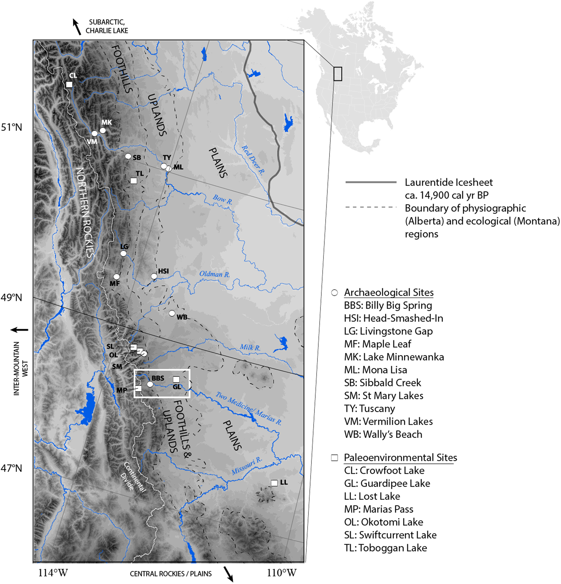
Figure 1. Map of the northern Rocky Mountain Front and sites mentioned or referenced in text. The map inset (white box) refers to Fig. 4. Laurentide Ice Sheet boundary from Dalton et al. (Reference Dalton, Margold, Stokes, Tarasov, Dyke, Adams and Allard2020); boundary of Montana ecoregions from Woods et al. (Reference Woods, Omernik, Nesser, Shelden, Comstock and Azevedo2002); and boundary of Alberta physiographic regions from Downing and Pettapiece (Reference Downing and Pettapiece2006).
Proposed occupations and abandonments of the region are multiple. Its location at the southern end of the “ice-free corridor” between the retreating Laurentide and Cordilleran Ice Sheets would make the Northern Front the place of arrival for Beringian immigrants by ca. 14,000 cal yr BP (Potter et al., Reference Potter, Baichtal, Beaudoin, Fehren-Schmitz, Haynes, Holliday and Holmes2018). Conversely, the Northern Front may have been a point of departure for Younger Dryas (12,900–11,700 cal yr BP) Plains Paleoindians on their way to the Arctic (Smith and Goebel, Reference Smith and Goebel2018). Furthermore, during the Early and Middle Holocene (11,700–8200 and 8200–4200 cal yr BP, respectively), the Northern Front may have offered refuge at times of major environmental disturbances affecting the Northwestern Plains, including the Holocene Thermal Maximum period of heightened aridity (sometimes referred to as the Altithermal, and regionally dated ca. 10,600–6800 cal yr BP; Reeves, 1973; Sheehan, Reference Sheehan1995; Meltzer, Reference Meltzer1999; Yansa, Reference Yansa2007) and the Mazama volcanic ashfall ca. 7600 cal yr BP (Oetelaar and Beaudoin, Reference Oetelaar and Beaudoin2005, Reference Oetelaar and Beaudoin2016).
As attractive as they may be, these models remain for the most part contested, as archaeological and paleoenvironmental evidence that may either support or falsify them is limited (but see Mandryk [Reference Mandryk1996], Beaudoin and Oetelaar [2003], Dyke [Reference Dyke2005], and Heintzman et al. [Reference Heintzman, Froese, Ives, Soares, Zazula, Letts and Andrews2016] for the latter). The general dearth of early archaeological sites in stratigraphic context in the Northern Front hinders discussions of local or regional material culture variability and ecological or social mechanisms of population movement. Hypotheses of early settlement and dispersal are instead primarily based on the archaeological records of adjacent regions with more intact stratigraphic contexts, such as the central Great Plains, the Intermountain West, or the Subarctic (e.g., Frison, Reference Frison, Stanford and Day1992; Davis, Reference Davis, Soffer and Praslov1993; Smith and Goebel, Reference Smith and Goebel2018).
Geomorphic processes affecting the region during deglaciation and the postglacial have made the identification of accessible, early archaeological contexts challenging. Many of those have been eroded or are deeply buried, particularly in landforms such as major river valleys and lakes, where archaeological research is typically conducted (see geomorphology section below). There are, however, other landform types that have seldom received archaeological attention but that have comparatively high potential for yielding archaeological evidence of early human activity.
In this paper, we leverage findings from archaeological and geologic work at a glacial kettle landform, the Billy Big Spring site (Blackfeet Indian Reservation, Montana), to contribute to the understanding of the succeeding settlement phases of the Northern Front. We further discuss the potential of glacial kettle landforms at large for contributing to a larger and better-dated sample of high-resolution archaeological and paleoenvironmental deposits that can be sampled in a practical manner.
THE NORTHERN ROCKY MOUNTAIN FRONT
The Northern Front consists of the transition between the Northwestern Plains and the Northern Rocky Mountains (including the southern Canadian Rocky Mountains) east of the Continental Divide. For the purposes of this article, we include in this definition the adjacent foothills (“Eastern Slopes” in Canada) and uplands (Downing and Pettapiece, Reference Downing and Pettapiece2006). The Northern Front stretches approximately from the Grand Canyon of the Missouri north to the headwaters of the Red Deer River (Fig. 1). Today, this region includes multiple biomes, from fescue grassland to alpine meadows, whose distribution varies with latitude and altitude (Downing and Pettapiece, Reference Downing and Pettapiece2006).
Geomorphology
At the peak of the late Pleistocene (Wisconsinan) glaciation, the Laurentide Ice Sheet coalesced with the Cordilleran Ice Sheet and montane and piedmont glaciers (Pinedale glaciation in Montana) over much of the Northern Front, with tracts of unglaciated land separating them on the Porcupine Hills and just south of the Alberta–Montana border (Bobrowsky and Rutter, Reference Bobrowsky and Rutter1992; Cannon, Reference Cannon1996; Fullerton et al., Reference Fullerton, Colton, Bush, Ehlers and Gibbard2004; Jackson et al., Reference Jackson, Leboe, Little, Holme, Hicock, Shimamura and Nelson2008; Dalton et al., Reference Dalton, Margold, Stokes, Tarasov, Dyke, Adams and Allard2020). Ice sheets and glaciers left a dramatic mark on the landscape, with deep U-shaped valleys in the mountains and thick glacial deposits on the foothills and the plains (Fenton et al., Reference Fenton, Waters, Pawley, Atkinson, Utting and Mckay2013; Atkinson et al., Reference Atkinson, Pawley, Andriashek, Hartman, Utting and Atkinson2020).
Along with the rest of the Ice-Free Corridor, the Northern Front underwent deglaciation during the terminal Pleistocene. Deglaciation in the Ice-Free Corridor at large produced a rapidly changing landscape consisting of piedmont and valley glaciers, nunataqs, stagnant ice, proglacial lakes, and eolian sediments (Fenton et al., Reference Fenton, Waters, Pawley, Atkinson, Utting and Mckay2013; Freeman, Reference Freeman, Kornfeld and Huckell2016; Pedersen et al., Reference Pedersen, Ruter, Schweger, Friebe, Staff, Kjeldsen and Mendoza2016; Munyikwa et al., Reference Munyikwa, Rittenour and Feathers2017; Potter et al., Reference Potter, Baichtal, Beaudoin, Fehren-Schmitz, Haynes, Holliday and Holmes2018). This complex landscape may arguably have hindered human settlement (Dawe and Kornfeld, Reference Dawe and Kornfeld2017).
Sedimentary archives of terminal Pleistocene and Early Holocene age in the Northern Front are typically preserved or identified in a limited range of stratigraphic contexts. Landscape remodeling along major river valleys, especially during the terminal Pleistocene (high-energy glaciofluvial discharge) and Middle/Late Holocene (high-energy alluvial discharge and slope processes, rise of water level due to damming) may have reduced visibility for archaeological sites there (Knox, Reference Knox and Wright1983; Wilson and Burns, Reference Wilson, Burns, Bonnichsen and Turnmire1999; Oetelaar, Reference Oetelaar2002, Reference Oetelaar2004; Beaudoin and Oetelaar, Reference Beaudoin and Oetelaar2003). Surviving records in major valleys tend to be deeply buried and, close to the mountains, dominated by large debris. As a result, they have rarely been sampled by archaeologists (Wilson and Burns, Reference Wilson, Burns, Bonnichsen and Turnmire1999), except for some cultural resource management recovery projects (Fedje et al., Reference Fedje, White, Wilson, Nelson, Vogel and Southon1995; Vivian et al., Reference Vivian, Wilson and Amundsen-Meyer2017).
While deposits on interfluves along the Northern Front have been stable through much of the postglacial (Waters and Rutter, Reference Waters, Rutter and Mahaney1984), early archaeological sites so far have been found either in thin deposits as low-resolution palimpsests (e.g., Gryba, Reference Gryba1983) or redeposited on the surface through deflation or colluviation (e.g., McNeil et al., Reference McNeil, Hills, Kooyman, Tolman, Kooyman and Kelley2004; Kooyman et al., Reference Kooyman, Hills, McNeil and Tolman2006). There are no cave archaeological deposits in the Northern Front, and they are rare throughout the ice-free corridor, with the exception of Charlie Lake Cave (Fladmark et al., Reference Fladmark, Driver and Alexander1988). Mountain glacial lake basins show a combination of geomorphological traits in single localities, including deeply buried deposits often remaining inaccessible below the water table and shallow deposits with high colluviation potential. Erosion due to modern infrastructure such as dams and bridges has further conspired to damage and obscure those lakeshore contexts (e.g., Landals, Reference Landals2008; Zedeño et al., Reference Zedeño, Pailes, Lanoë, Ballenger, Daughtrey, Bethke and White2016).
Paleoenvironments
Paleoenvironmental sites in the Northern Front are affected by similar preservation issues as seen at archaeological sites, with little recent published research (see Beaudoin, Reference Beaudoin1993). Dating is an added concern because of regional coal and carbonate bedrock enrichment, particularly for lacustrine cores (Wilson, Reference Wilson, Barendregt, Wilson and Jankunis1993). Paleoenvironments are documented in a few, disparate, higher-resolution palynological and sedimentological records (Fig. 2), to which lower-resolution records (including macrofossils) can loosely be correlated (Beaudoin and Oetelaar, Reference Beaudoin and Oetelaar2003). Those pollen records provide the best approximation of past environments, with the caveat that they may not be entirely representative of vegetation diversity.
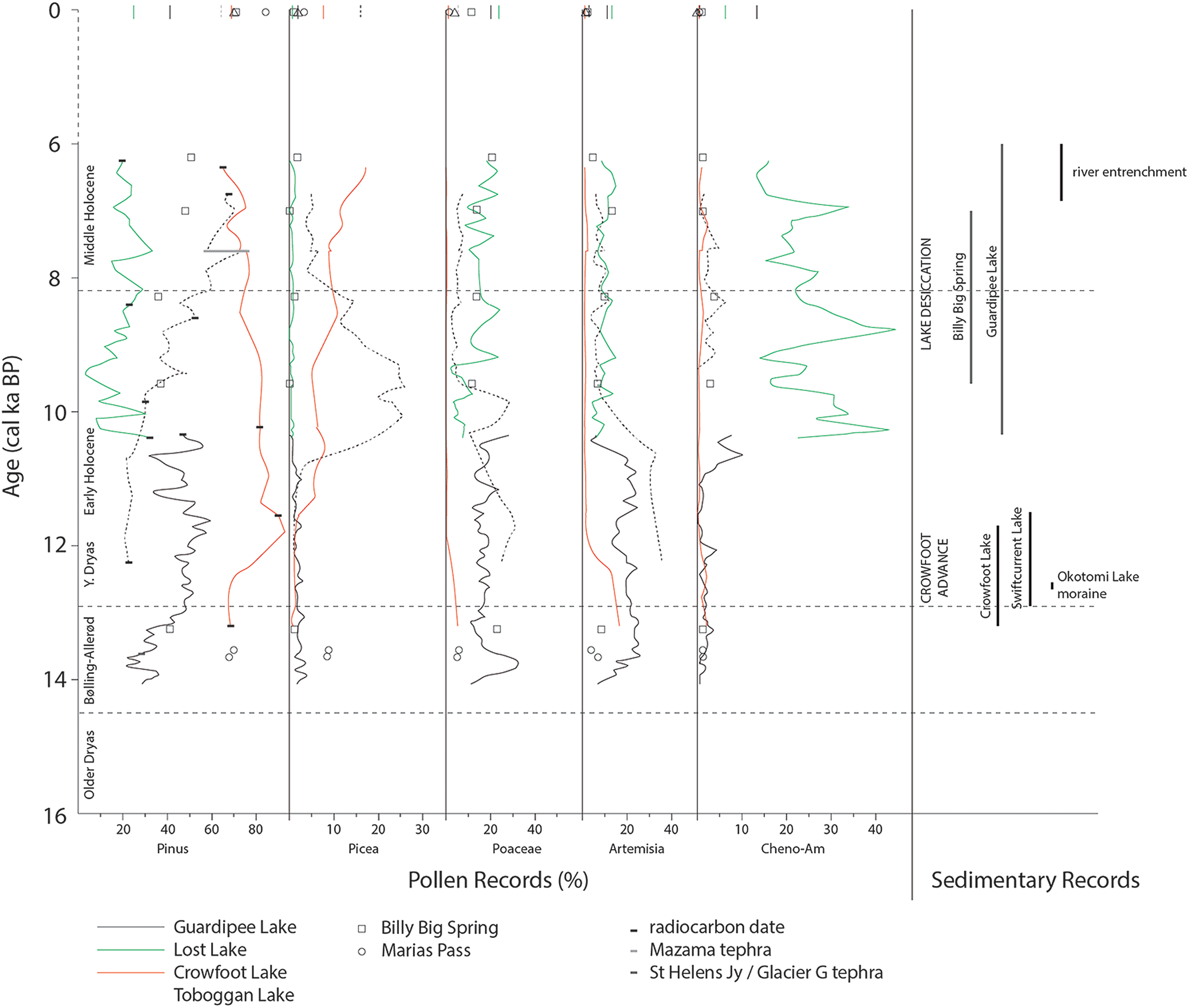
Figure 2. Selected palynological and sedimentary records from sites across the Northern Rocky Mountain Front. Pollen counts from lacustrine cores are stretched to match stratigraphic control ages (only indicated here for Pinus for ease of reading). Curve start points do not represent the earliest lacustrine deposition at each site but the earliest date available, except for Guardipee Lake, where the author estimated the oldest age based on sedimentation rates (Barnosky, Reference Barnosky1989). Curve endpoints represent the closest reliable date to 6000 cal yr BP. Full pollen counts and associated radiocarbon dates for Billy Big Spring are listed in Supplemental Table 1 and Table 3, respectively.
Based on their pollen assemblages, sites located on or near the plains, such as Lost and Guardipee Lakes, are characterized throughout the terminal Pleistocene and Early Holocene by herbaceous and/or shrubby vegetation (Barnosky, Reference Barnosky1989). Initial steppe-like vegetation, with high proportions of sagebrush (Artemisia) and grasses (Poaceae), was succeeded at the onset of the Holocene Thermal Maximum ca. 10,500 cal yr BP by more xeric grasslands with high Cheno-Am (Amaranthaceae, formerly Chenopodiaceae and Amaranthaceae) proportions. Neither of these vegetation types are truly analogous to the more mesic modern prairie dominated by grasses. In parallel, sites in high-elevation settings or mountain valleys document forest development from initial open (steppe- or alpine-like) vegetation, with a time lag based on latitude and altitude (Carrara, Reference Carrara1989; MacDonald, Reference MacDonald1989; Reasoner and Huber, Reference Reasoner and Huber1999). Marias Pass at 48.3°N shows arboreal pollen proportions (particularly spruce [Picea]) comparable to historical levels as early as 13,600 cal yr BP, whereas Crowfoot Lake at 51.6°N does not show similar levels until ca. 11,500 cal yr BP, nor does Toboggan Lake in the foothills at 50.8°N until ca. 10,500 cal yr BP. Pine (Pinus) pollen also rises on plains sites, reaching levels similar to modern ca. 13,000 cal yr BP at Guardipee Lake at 48.6°N (Barnosky, Reference Barnosky1989), probably reflecting forest development in adjacent regions.
Sedimentary records of the Northern Front corroborate the temporal and geographic variation visible in palynological studies (Fig. 2). Cores from mountain glacial lakes such as Swiftcurrent Lake, Okotomi Lake, and Crowfoot Lake, record the cooler climatic conditions associated with glacial advances during the Younger Dryas (12,900–11,700 cal yr BP) (Reasoner et al., Reference Reasoner, Osborn and Rutter1994; MacLeod et al., Reference MacLeod, Osborn and Spooner2006; MacGregor et al., Reference MacGregor, Riihimaki, Myrbo, Shapley and Jankowski2011). Regional river entrenchment marks the wetter conditions of the Middle to Late Holocene (Knox, Reference Knox and Wright1983; Oetelaar, Reference Oetelaar2002). In contrast, the Holocene Thermal Maximum is characterized by montane glacier retreats (Beierle and Smith, Reference Beierle and Smith1998; Leonard and Reasoner, Reference Leonard and Reasoner1999; MacGregor et al., Reference MacGregor, Riihimaki, Myrbo, Shapley and Jankowski2011), complete or partial lake desiccation (Barnosky, Reference Barnosky1989; Hickman and Schweger, Reference Hickman and Schweger1993; Beierle and Smith, Reference Beierle and Smith1998), and river valley stability or aggradation (Knox, Reference Knox and Wright1983; Oetelaar, Reference Oetelaar2002; Beaudoin and Oetelaar, Reference Beaudoin and Oetelaar2003).
Archaeology
The terminal Pleistocene and Early Holocene archaeological record of the Northern Front has, accordingly, relatively imprecise chronological control. Documented deeply buried sites of terminal Pleistocene and Early Holocene age are limited to a handful of isolated locales, including the Vermilion Lakes (Fedje et al., Reference Fedje, White, Wilson, Nelson, Vogel and Southon1995) and Lake Minnewanka (Landals, Reference Landals2008) sites in the upper Bow valley; the Tuscany (Oetelaar, Reference Oetelaar2004) and Mona Lisa (Wilson, Reference Wilson1974) sites in the Calgary area; and the Maple Leaf (Driver, Reference Driver1978), Head-Smashed-In (Reeves, Reference Reeves1978), and Livingstone Gap (Reeves and Dormaar, Reference Reeves and Dormaar1972) sites in the Oldman/Crowsnest Rivers area. Other finds in primary context have been documented in shallow stratigraphy with low temporal resolution, such as at the Sibbald Creek site (Gryba, Reference Gryba1983). Overwhelmingly, most early postglacial finds in the Northern Front are surface finds (Reeves, Reference Reeves2003; Peck, Reference Peck2011; Ives et al., Reference Ives, Yanicki, Supernant and Lakevold2019).
Compounding the complex geomorphology of the Northern Front are the idiosyncrasies of regional Paleoindian lithic technologies that do not conform with classic typologies and raw material procurement strategies. The record contains few Clovis projectile points, and none of them are precisely dated—as elsewhere in the ice-free corridor (Fladmark et al., Reference Fladmark, Driver and Alexander1988). Large lanceolate stemmed points (e.g., Fedje et al., Reference Fedje, White, Wilson, Nelson, Vogel and Southon1995; Reeves, Reference Reeves2003) may relate to either (arguably) Early Paleoindian technologies such as Western Stemmed (Smith et al., Reference Smith, Duke, Jenkins, Goebel, Davis, O'Grady, Stueber, Pratt and Smith2020) or younger points such as Hell Gap. Wedge-shaped microcores that could relate to the Beringian tradition, in particular a southern movement of people of the Denali complex, have only been found to postdate 13,000 cal yr BP (Wilson et al., Reference Wilson, Visser and Magne2011; Magne et al., Reference Magne, Hughes and Kristensen2020). Ironically, the earliest occupation in the region (and with the best chronological resolution), the kill site at Wally's Beach, does not contain projectile points in situ (McNeil et al., Reference McNeil, Hills, Kooyman, Tolman, Kooyman and Kelley2004; Kooyman et al., Reference Kooyman, Hills, McNeil and Tolman2006, Reference Kooyman, Hills, Tolman and McNeil2012), and its cultural attribution is disputed (Waters et al., Reference Waters, Stafford, Kooyman and Hills2015). During the Late Paleoindian and Early Archaic, projectile point types are often defined at an eponymous site and rarely identified elsewhere, making intra- or interregional comparisons difficult (Peck, Reference Peck2011).
Raw material procurement is also regionally specific, as it favored locally available sources (Ives et al., Reference Ives, Froese, McLaren, Gusick, Graf, Ketron and Waters2013), with some exceptions (e.g., Wilson et al., Reference Wilson, Visser and Magne2011; Kristensen et al., Reference Kristensen, Moffat, Duke, Locock, Sharphead and Ives2018). It is characterized by extensive use of local cherts, quartzites, and argillites (often procured from glacial till) that do not possess the highest structural quality needed to manufacture the large points and bifaces characteristic of Paleoindian assemblages to the south and east. The regional pattern instead suggests a compromise between readily available raw materials and limited procurement of exotic high-quality ones.
SETTING AND METHODS
Kettles in the Northern Front are a legacy of the terminal Pleistocene glaciations. They formed through ice stagnation during the recession of ice-sheet and piedmont glaciers. Following formation of the basin, the presence of water in a perennial or seasonal form created conditions for the continuous deposition of horizontally stratified layers of fine-grained sediments, as in other lacustrine contexts.
We investigated the archaeological and paleoenvironmental records of kettles through excavation of the Billy Big Spring kettle and survey of adjacent kettles in the Blackfeet Indian Reservation located in the southern part of the Northern Front (Fig. 3). All kettles investigated here were formed during the retreat stages of the Two Medicine piedmont glacier, dating to between ca. 26,000 and 14,000–13,000 cal yr BP (Carrara, Reference Carrara1995; Fullerton et al., Reference Fullerton, Colton, Bush, Ehlers and Gibbard2004; Kuehn et al., Reference Kuehn, Froese, Carrara, Foit, Pearce and Rotheisler2009). Together they form a physiographic transect across the Northern Front, from the plains to the mountains, facing the Lewis/Sawtooth Ranges in the Two Medicine River drainage.

Figure 3. Map of the kettles surveyed in this study in relationship to advances of the Two Medicine Piedmont Glacier. Detailed information for each kettle is listed in Table 1. Boundaries of glacial maxima from Fullerton et al. (Reference Fullerton, Colton, Bush, Ehlers and Gibbard2004); location of chert-bearing exposures from Cannon (Reference Cannon1996) and Mudge and Earhart (Reference Mudge and Earhart1983).
Table 1. Geographic, geomorphologic, and environmental characteristics of the kettles surveyed.

a BBS, Billy Big Spring.
Billy Big Spring (24GL304) is a small kettle (ca. 0.5 ha) located in the foothills. It formed sometime between 23,360 and 13,840–13,490 cal yr BP, most likely on the younger end of this age range (Carrara, Reference Carrara1995; Carrara et al., Reference Carrara, Short and Wilcox1986; Fullerton et al., Reference Fullerton, Colton, Bush, Ehlers and Gibbard2004; Kuehn et al., Reference Kuehn, Froese, Carrara, Foit, Pearce and Rotheisler2009). Excavations at Billy Big Spring build upon initial investigations by Thomas Kehoe in the 1950s. Kehoe excavated a trench on the southern edge of the kettle basin and identified four archaeological components that, based on projectile point style and depth of recovery, he attributed to a possible Paleoindian occupation and several occupations of the Archaic and Late Prehistoric periods (Kehoe, Reference Kehoe2001). Since 2016 we have excavated additional areas near Kehoe's initial work (block 1000), on the western edge of the basin (blocks 100–300), and on the adjacent southern ridge (block 600) (Fig. 4). Excavations were conducted by trowel with wet screening of sediments at a mesh size of 3.2 mm (⅛ inch). Alongside excavation, the landform was systematically surveyed by shoulder-to-shoulder interval in 2016 and has since been monitored annually to document the effects of continued cattle trampling on waterlogged sediments.
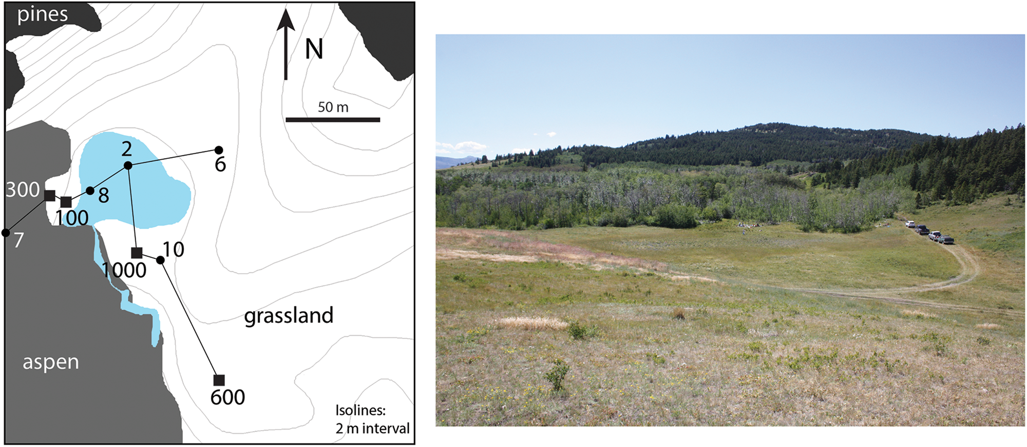
Figure 4. Left, map of the Billy Big Spring kettle and stratigraphic transects of excavation blocks (100 to 1000) and auger cores (2 to 10, including one in block 100). Right, photograph of the landform from a point near the map's north arrow, looking WSW, with block 300 in the background.
The site stratigraphy was recorded in a series of six bucket auger holes along two transects across the site (Fig. 4). Each auger hole was taken down to the glacial outwash. Sediments and soils were described and recorded using standard nomenclature. We collected sediment samples with a standard soil auger (10 cm diameter). Only compact sediments were analyzed, with removal of loosely compacted slump. Samples from each stratigraphic unit were analyzed for particle size analysis, calcium carbonate contents, and organic matter contents, providing rationales for sedimentary and pedogenic interpretations. Particle size distributions were calculated using the pipette method (Janitzky, Reference Janitzky, Singer and Janitzky1986a). Calcium carbonate and organic matter contents were measured using the Chittick and Walkley-Black methods, respectively (Janitzky, Reference Janitzky, Singer and Janitzky1986b; Machette, Reference Machette, Singer and Janitzky1986).
A total of 15 pollen samples were collected along a 1.5 m stratigraphic column in block 100 and sent for analysis to the PaleoResearch Institute, Golden, Colorado (Supplementary Table 1). Briefly, pollen samples were first treated with hydrochloric acid and EDTA and decanted to remove calcium carbonates, clay, and soluble organics; and then treated with sodium polytungstate and hydrofluoric acid and centrifugated to remove inorganic remains and silica. Pollen grains were then counted under a light microscope (500×).
Archaeological survey work was conducted at an additional 24 kettles during the summer of 2019 (Fig. 3). Most kettles, like Billy Big Spring, are heavily affected by cattle trampling that is expected to bring cultural materials to the surface. Kettles vary in size from 0.2 to 7.8 ha (Table 1). We surveyed the extent of the basins (above water if present), focusing on areas such as water edges, where bioturbation was most intense and cultural materials would be most visible.
RESULTS
Billy Big Spring Archaeological Site
Billy Big Spring's stratigraphy in the basin and on its margin consists of alternating layers of variable thickness, texture, and composition (Fig. 5, Table 2). Organic archaeological, paleoenvironmental, and chronological proxies are multiple. Thick waterlogged clay deposits in the pond basin preserve macrobotanical remains (seen in the sediments but not sampled for this study) and pollen that can be used in vegetation reconstruction. Thinner deposits on the margin of the basin provide pedogenic paleoenvironmental markers such as biogenic carbonates. Animal bones and combusted wood (charcoal and ash) are present in both basin and margin deposits. Most combusted wood is preserved as ash or microcharcoal rather than macrocharcoal, as expected in moderately to strongly alkaline conditions (Braadbaart et al., Reference Braadbaart, Poole and van Brussel2009).

Table 2. Summary of strata characteristics, including texture (standard USDA particle size nomenclature), % organic matter (OM), and % carbonate (CaCO3) (both from block 100), and lithostratigraphic and pedological interpretations (from Jansson, Reference Jansson2017).
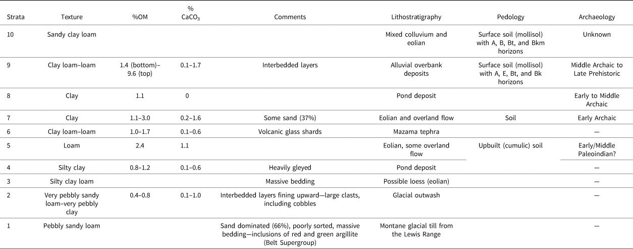
Table 3. Radiocarbon dates from Billy Big Spring (Blackfeet Indian Reservation, Montana).a
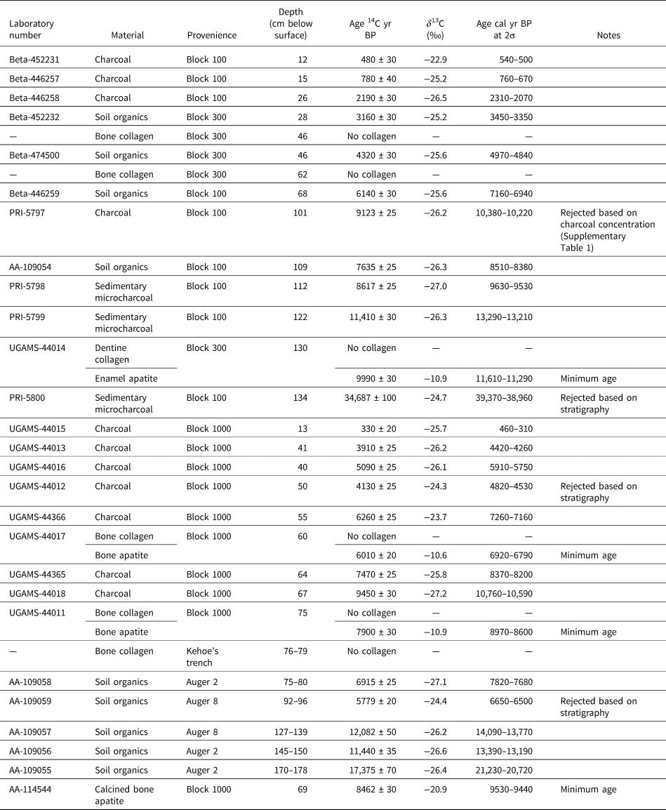
a Calibration conducted with OxCal 4.3 and IntCal13 (Bronk Ramsey, Reference Bronk Ramsey2009; Reimer et al., Reference Reimer, Bard, Bayliss, Beck, Blackwell, Bronk Ramsey and Grootes2013).
The accuracy of chronometric dating varies with the type of dated materials (Table 3). Radiocarbon dates on microcharcoal and soil organics in the thick basin sediments generally corroborate chronological markers such as projectile points (based on the culture history of the Northwestern Plains), with some exceptions (Figs. 5 and 6). Radiocarbon dates on charcoal in thinner deposits on the margin of the basin generally appear too young by up to two millennia when compared with cultural chronological markers (Fig. 5); this probably relates to the lag in sedimentation following deposition of archaeological materials and/or the dominance of pedogenic rather than archaeological carbon. Collagen in faunal materials is too degraded for dating, probably due to frequent fluctuations in sediment water contents (Nielsen-Marsh and Hedges, Reference Nielsen-Marsh and Hedges2000). Biogenic apatite (bone and teeth) produces aberrantly young radiocarbon dates, reflecting the intake of dissolved environmental carbon (Olson and Broecker, Reference Olson and Broecker1961; Cherkinsky et al., Reference Cherkinsky, Glassburn and Reuther2015) and essentially providing minimum ages (Fig. 2).
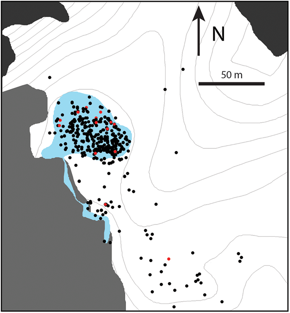
Figure 6. Sample of diagnostic projectile points found at Billy Big Spring, in situ (blocks 100, 300, and 1000, with associated strata) and on the surface. Culture history and associated ages are based on the projectile point sequence of the northwestern Great Plains (Peck, Reference Peck2011) (s.l.: sensu lato).
Each layer can be interpreted in terms of lithostratigraphy based on its characteristics, location, and age (Fig. 5, Table 2; also see Jansson, Reference Jansson2017). Postglacial sedimentation occurred atop very pebbly glaciofluvial deposits (strata 1 and 2) and continued until the present time. Clay-rich and sometimes gleyed pond deposits (strata 4 and 8) are thickest in the center of the basin (augers 2 and 8), where deposition may have been relatively continuous since the formation of the kettle. Also present is a thick (10–15 cm) tephra deposit (stratum 6) that, based on its position in the stratigraphy, can be attributed to the Mazama eruption. Pond deposits on the edge of the modern basin correspond to periods of high water levels and interfinger with coarser sediments. The latter likely correspond to eolian and/or overland flow sediments (strata 5 and 7) deposited at times of low water levels. They are capped by deposits (stratum 9) where interbedding denotes an alluvial origin, likely from the stream near auger 7, where this stratum is thickest. Deposition on or below the slopes outside the basin (block 600, augers 6 and 10) is dominated by colluvial processes (stratum 10).
Pedogenesis denoting periods of landform surface stability is evident among eolian, overland flow, and colluvial deposition (Fig. 5, Table 2; also see Jansson, Reference Jansson2017). Both buried and surface soils display classic trends in carbonate and organic matter contents (high percentages near the surface declining with depth). Surface soils also display horizons typical of the local mollisols (Haigh, Reference Haigh1980), with the presence of argillic (Bt) and petrocalcic (Bkm) horizons indicating long-term surface stability.
Archaeological materials at Billy Big Spring are present as stratified occupations, palimpsests, and surface materials, including features, projectile points, tools, debitage, and faunal materials in varying densities (e.g., Lanoë et al., Reference Lanoë, Zedeño, Jansson, Soza and Blackfeet2020). Buried occupations are associated with distinct paleosol surfaces that can generally be correlated across the excavation blocks (Fig. 5, blocks 100, 300, and 1000); each of those paleosols formed on what constituted the edge of the pond during the respective time of occupation. Low-resolution palimpsests are found in the shallow colluvial deposits outside the basin (Fig. 5, block 600). Surface materials are found throughout the landform and cluster on the waterlogged deposits in the extent of the modern basin, where they are brought to the surface by cattle trampling (Fig. 7).
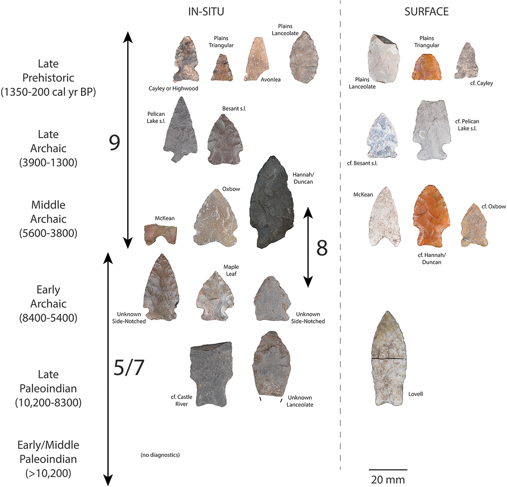
Figure 7. Surface finds at Billy Big Spring (red, projectile points).
The modes and rate of deposition of the different strata and their pedogenic alteration at Billy Big Spring generally agree well with regional paleoclimatic, paleoenvironmental, and archaeological records. The earliest age for sedimentation of the basin at 13,900 cal yr BP falls within the estimated range of deglaciation of Marias Pass, upstream on the Two Medicine piedmont glacier (Carrara, Reference Carrara1995; Fullerton et al., Reference Fullerton, Colton, Bush, Ehlers and Gibbard2004; Kuehn et al., Reference Kuehn, Froese, Carrara, Foit, Pearce and Rotheisler2009). Subsequent lacustrine sedimentation over the entire basin (stratum 4) corresponds to the terminal Pleistocene and wetter phase of the early Holocene (before ca. 10,600 cal yr BP) as estimated from regional paleoenvironmental records (Fig. 2). Probable Middle and/or Early Paleoindian materials (including tools, debitage, and faunal materials, but not diagnostic projectile points) are present immediately above and within glacial outwash (e.g., Fig. 8), suggesting some degree of secondary deposition and relocation associated with terminal Pleistocene paraglacial processes.
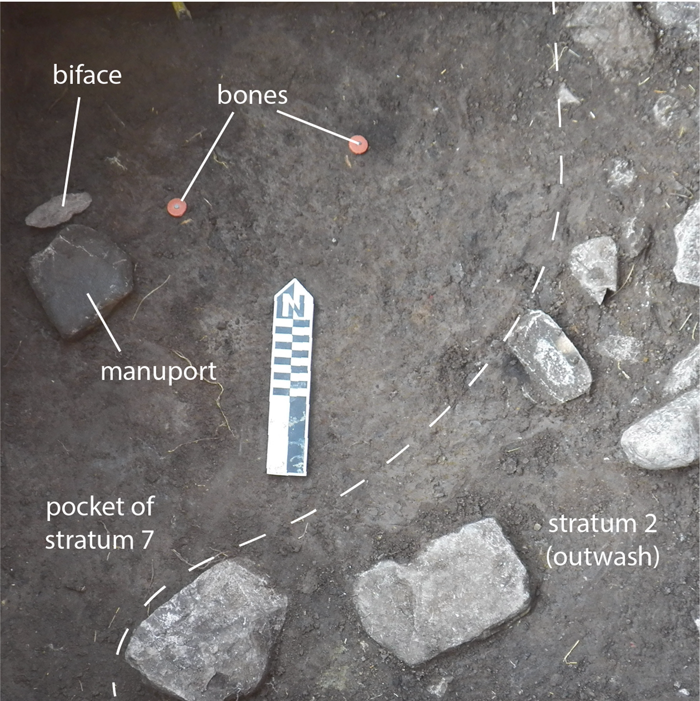
Figure 8. Pocket of stratum 7 with associated archaeological materials at the bottom of block 1000, embedded within glacial outwash. Scale in centimeters.
Shrinking of the pond to the center of the basin correlates with regional evidence of aridity during the Holocene Thermal Maximum. Late Paleoindian and Early Archaic materials are associated with paleosols ranging in age from 10,680 to 7050 cal yr BP and are located within strata 5 and 7, respectively. Where Mazama tephra is preserved, it immediately underlies the Early Archaic occupations. Billy Big Spring retained water in the center of its basin throughout the Holocene Thermal Maximum, unlike much deeper lakes in the plains such as Guardipee Lake (Barnosky, Reference Barnosky1989). This water persistence at Billy Big Spring illustrates the effect of elevation on groundwater availability, wherein proximity to sources of precipitation runoff and differences in particle size of the piedmont till that dominates the foothills provides a higher and more perennial aquifer or shallower groundwater than in the plains (Cannon, Reference Cannon1996; Karlstrom, Reference Karlstrom2000). Dense Middle Archaic to Protohistoric occupations (e.g., Lanoë et al., Reference Lanoë, Zedeño, Jansson, Soza and Blackfeet2020) are preserved in alluvial sediments ranging in age from 5830 to 520 cal yr BP, during the cooler and wetter Middle to Late Holocene.
Palynological patterns at Billy Big Spring are generally intermediate between those observed in the plains and in the mountains (Fig. 2, Supplementary Table 1). Environments were open until the beginning of the Holocene Thermal Maximum with arboreal (mostly pine) proportions lower than modern levels (as indicated by surface samples), and herb and shrub composition similar to plains sites. There is a limited rise in Cheno-Am during the Holocene Thermal Maximum compared with the neighboring plains, which may relate to differences in the composition of the surrounding grasslands (more mesic) or factors local to the pond (available surface area of mudflats). Modern-like vegetation does not appear in the plains until the Middle Holocene.
Survey
The single archaeologically positive locality was Kettle 33, located in the foothills nearby Billy Big Spring (Fig. 3), where we documented a Late Prehistoric projectile point, a scraper, and a few unmodified flakes. This kettle did not exhibit bioturbation and may thus contain intact buried archaeological deposits.
DISCUSSION
Billy Big Spring provides a valuable contribution to the archaeological record of the Northern Front, as the site contains a stratified record of human occupation through most major phases of the Northwestern Plains prehistory. Specifically, it contains evidence, rare regionally, of sequential Late Paleoindian and Early Archaic settlement during the midst of the Holocene Thermal Maximum and both before and after the Mazama eruption. Future excavations and dating of the site may clarify whether and which earlier (Pleistocene) Paleoindian groups occupied the site.
The Billy Big Spring archaeological and paleoenvironmental records suggest that the foothills of the Northern Front were occupied continuously throughout major environmental disturbances of the Early to Middle Holocene, and probably the terminal Pleistocene as well. This pattern may in large part result from favorable local environmental conditions, as foothill kettles such as Billy Big Spring (and others, such as Kettle 33) provided permanent water, shelter from weather and enemies, and ease of access to a range of mineral (tool stone) and plant resources (including fuel and berries). In contrast, kettles in the plains would have lacked one or several of these characteristics. Favorable conditions in the foothills likely attracted hunter-gatherers, as well as the large animals they depended upon, throughout prehistory (Peck, Reference Peck2004; Zedeño, Reference Zedeño, Thompson and Waggoner2013). Such settings would have become even more attractive during the Holocene Thermal Maximum, when foothill kettles buffered the effects of regional climate change and contributed to the persistence of more mesic local conditions.
Findings at Billy Big Spring are thus in general agreement with a number of archaeological models that suggest differential use, in the Northwestern Plains, of uplands (sensu lato) and plains habitats during the terminal Pleistocene and early to Middle Holocene. The presence of “foothill” (Lovell/Castle River) rather than “plains” (e.g., Cody Complex) Late Paleoindian projectile point types generally corroborates the seemingly ecological, and possibly demographic, disassociation of Early Holocene Paleoindian populations (Frison, Reference Frison, Stanford and Day1992). Reliance and economic focus on a persistent water source likewise mirror concepts of oases or ecological refugia conditioned by the presence of groundwater or perched aquifers and located on the margins of the plains (Sheehan, Reference Sheehan1994, Reference Sheehan1995; Yansa, Reference Yansa2007). The broken terrain of the foothills and its sheltering opportunities may also have buffered the effects of the Mazama ash fall (Oetelaar and Beaudoin, Reference Oetelaar and Beaudoin2005, Reference Oetelaar and Beaudoin2016) and/or favored a faster reoccupation of the region. Meanwhile, probable Pleistocene materials, while still uncharacterized, are a reminder of the affinities of Early–Middle Paleoindian populations for montane environments (e.g., Fedje et al., Reference Fedje, White, Wilson, Nelson, Vogel and Southon1995; Pitblado, Reference Pitblado2017).
The Billy Big Spring record suggests that kettles in general have a high potential for providing additional accessible and well-preserved terminal Pleistocene and Early Holocene archaeological and paleoenvironmental records in stratigraphic context. Preservation, identification, and accessibility of the archaeological record at Billy Big Spring is largely due to the geomorphic characteristics of the kettle landform on which it is located, and those characteristics should hold true regardless of physiographic setting. As such, archaeological work in kettle landforms may in the future contribute to testing alternative archaeological models about the settlement of the Northwestern Plains; for instance, those that posit that the dearth of Early Archaic sites in the plains is largely due to geologic factors without providing evidence of abandonment (Reeves, Reference Reeves1973; Oetelaar, Reference Oetelaar2004; Robertson, Reference Robertson2011).
More generally, deeply buried deposits are more likely to preserve archaeological occupations in stratigraphic context than shallow deposits prone to compression, deflation, and colluviation. Surface finds of fluted points in the ice-free corridor show how postdepositional and erosional factors differentially affect terminal Pleistocene deposits (Gillespie, Reference Gillespie2002; Freeman, Reference Freeman, Kornfeld and Huckell2016; Ives et al., Reference Ives, Yanicki, Supernant and Lakevold2019). Most fluted points are associated with landforms where sediment was not deposited or where shallow deposits were reworked by deflation (sand dune, extinct lake, floodplain; 27% of finds in Gillespie [2002]) or by colluviation (moraine, valley uplands, hilltop; 59% of finds in Gillespie [2002]). In contrast, there are few finds in landforms where points may have been exposed from deep deposits by processes such as degradation (terrace, spring, stream; 9% of finds in Gillespie [2002]).
A corollary to preservation is the ease of sampling. Identification of buried archaeological deposits is facilitated by postdepositional processes, whether geogenic or biogenic, that bring archaeological materials to the surface, the rate of which is negatively correlated with burial depth. Deeper deposits are often only revealed inadvertently by infrastructure development, notably in localities that would not have seemed to have high archaeological potential. Shallowly buried deposits are also easier to sample than deep ones. Work effort and expenses of excavating large surface areas increases with depth due to the volume of sediment excavated and time-intensive procedures often associated with deep excavations, such as step-trenching or shoring, repeated backfilling, or excavation below a perched water table.
Deposit depth within a kettle basin such as Billy Big Spring varies from deep lacustrine deposits in the center to shallow and dominantly eolian or colluvial deposits on the edges. As such, sedimentation processes are similar, on a smaller scale and with comparatively less erosional action, to those of larger glacial lakes. Telling signs of archaeological occupation at Billy Big Spring are found on the surface of shallow deposits and in other areas, such as the center of the basin (Fig. 6). The latter likely preserves a high-density record of megafauna hunting—as evidenced by the number of projectile points found there (Fig. 6)—but in a mostly inaccessible state due to deposit depth, waterlogging, high degree of bioturbation, high clay percentage, and increased compaction of pond deposits. In contrast, deep deposits elsewhere in the basin preserve relatively untouched and high-resolution archaeological records, including occupations of a more domestic type, and paleoenvironmental archives. Resolution and excavation efficiency of such basin-edge deposits is conditioned by past fluctuations in water level, as clay-rich pond deposits slow down excavation but also provide sterile stratigraphic layers separating archaeological occupations.
CONCLUSION
Billy Big Spring provides a valuable addition to the archaeological and paleoenvironmental records of the Northern Front and the Northwestern Plains in general. The site contains a continuous archaeological record for the early to Middle Holocene, probably including parts of the terminal Pleistocene as well—both of which are regionally rare. Such findings specifically suggest that the foothills of the Northern Front offered favorable conditions for continuous occupation in the midst of broader regional environmental change. As such, Billy Big Spring helps to refine several models that attend to human dispersal and settlement in the region, particularly those that suggest differential settlement of the foothills as opposed to the plains in the Late Paleoindian and Early Archaic.
This paper offers additional perspectives for archaeological and paleoenvironmental research in the Northern Front. Billy Big Spring is the first kettle excavated in the region and shows how the geomorphic characteristics of these landforms are conducive to high-resolution preservation and identification of archaeological and paleoenvironmental archives of terminal Pleistocene to Early-Middle Holocene age. The larger survey presented here further shows that the archaeological potential of kettles assuredly relates to other factors rather than geomorphology alone. Nevertheless, findings at Billy Big Spring will encourage future work in similar geomorphic contexts, in the foothills of the Northern Front as well in different physiogeographic settings. Such research will undoubtedly contribute to build a sorely needed denser and better-dated record of human presence in this area than is currently available.
Acknowledgments
This work results from a collaboration between the Bureau of Applied Research in Anthropology at The University of Arizona, Tucson, and the Blackfeet Tribal Historic and Preservation Office (THPO), Browning, Montana (J. Murray, MA, Officer). Research at the Billy Big Spring site was made possible by short-term lease agreements with landowners R. and J. Wellman and J. and M. Running Fisher, and under permission from the Bureau of Indian Affairs Rocky Mountain Region. Funding for this work was provided by the National Science Foundation under grant PLR-1827975; the Montana Department of Transportation (DOT) as part of a Memorandum of Understanding with the Blackfeet Tribe that provided for off-site mitigation of negative impacts to cultural resources along the Montana Highway 89 expansion corridor; and the Argonaut Archaeological Research Fund (University of Arizona Foundation; V.T. Holliday, Director). Excavations and surveys were conducted with Blackfeet tribal members, including M. Bustamante, J. Comes at Night, B. Connelly, J. Desrosier, C. Fenner, D. Fenner, G. Hall, E. Kennedy, H. Running Crane, W. Running Crane, T. Running Fisher, T. Runningwolf, and R. St. Goddard. Professional oversight crew included, in addition to the authors, L. Bond Reis, E. Pickering, D. Soza, A. Thompson (The University of Arizona), and M. Pailes (University of Oklahoma). This work benefited at various stages from discussion and help from J. Murray, K. Edmo, and V. Edwards (Blackfeet THPO), S. Mandelko (Glacier National Park), M. Bodily (Helena-Lewis and Clark National Forest), S. Platt (Montana DOT), V. Haynes (The University of Arizona), and A. Freeman (University of Calgary). Successive versions of this paper were greatly improved by comments from A. Beaudoin, T. Faith, L. Gamble, A. Freeman, D. Booth, and several anonymous reviewers.
Supplementary Material
The supplementary material for this article can be found at https://doi.org/10.1017/qua.2021.40
Data Availability Statement
Fieldwork and sedimentological analysis at the Billy Big Spring is reported in Zedeño et al. (Reference Zedeño, Lanoë, Jansson, Soza and Thompson2018) and Jansson (Reference Jansson2017). Additional data are archived as digital and paper documents at the Bureau of Applied Research in Anthropology of the University of Arizona, Tucson, pending publication of research results. Pollen specimens and residues are archived at PaleoResearch Institute in Golden, Colorado.


 Open access